Geography of Missouri facts for kids
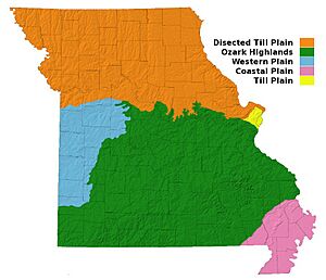
Missouri is a state located near the center of the United States. It has three main types of land, called physiographic divisions:
- The northern plains are a flat, grassy area in the northwest. This area is part of the Interior Plains' Central Lowland.
- The Mississippi Alluvial Plain is a low-lying area in the very southeast, often called the Bootheel. It is part of the Atlantic Plain.
- The Ozark Plateau is a raised, flat area that sits between the Mississippi Alluvial Plain and the northern plains.
The Missouri River helps mark the border between the northern plains and the Ozark region. This border runs from St. Louis to Columbia. This line also shows where glaciers once stopped during the Ice Age. The glaciers flattened the land to the north but left the older landforms to the south untouched. From Columbia, the Ozark border goes southwest towards Joplin. The border between the Ozarks and the lowlands runs southwest from Cape Girardeau to the Arkansas border near Poplar Bluff. Missouri shares its borders with eight other U.S. states. Only Tennessee borders as many states.
Contents
Missouri's Main Land Regions
The Northern Plains
The northern plains cover about one-third of Missouri. This region is a beautiful, rolling landscape with many streams. The western part of this area is hillier than the eastern part.
In the far northwest, the land is about 1,200 feet (366 meters) high. In the far northeast, it's about 500 feet (152 meters) high. The edge of this region, near the Ozarks, is about 900 feet (274 meters) high. The valleys of the larger streams are deep, about 250 to 300 feet (76 to 91 meters), and can be 8 to 20 miles (13 to 32 km) wide. The land near these valleys is the most rugged in the region.
Smaller streams have worn away much of the original flat surface. The Mississippi River flows along Missouri's eastern side. Along the river, the land rises sharply, about 400 to 600 feet (122 to 183 meters) high.
The Ozark Plateau
The Ozark region is shaped like a low dome. It has a high ridge that runs from near the Mississippi River in Ste. Genevieve to McDonald County on the Arkansas border. Along the Mississippi, tall, rocky cliffs rise sharply, sometimes 150 feet (46 meters) above the water. These cliffs show where the river cuts through the Ozark ridge.
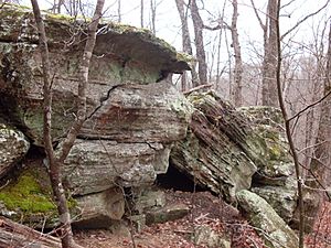
The highest points in the Ozarks in Missouri range from 1,100 to 1,700 feet (335 to 518 meters). This region makes up a little less than two-thirds of the state. A large cliff, called the Burlington escarpment, runs along the western edge. This cliff can be 250 to 300 feet (76 to 91 meters) high. It divides the Ozarks into two main areas: the Salem Plateau and the Springfield Plateau.
Rivers flowing south into the White River in Arkansas have created another cliff in the southern Ozarks. This area, from McDonald County to Howell County, is very rugged. The famous Shepherd of the Hills area near Branson is in this rugged part. East of West Plains, you'll find the deep valleys of the Eleven Point River and the Current River.
The Ozarks look like a rolling plateau, broken up by erosion. Some areas still have flat surfaces with underground rivers. There are also scattered rounded hills and short ridges with winding valleys. These hills are either what's left of eroded limestone or the tops of very old mountains that were covered by layers of rock and then uncovered again.
The two highest points in Missouri are Taum Sauk Mountain at 1,772 feet (540 meters) in the St. Francois Mountains and Lead Hill at 1,744 feet (532 meters) near Cedar Gap. Most places in the Ozarks are lower than 1,400 feet (427 meters). The Ozark region generally has wide, smooth valleys and rounded hills.
The Mississippi Alluvial Plain
The third region is the lowlands in the southeast, part of the Mississippi Alluvial Plain. This area covers about 3,000 square miles (7,770 square km). It is a rolling landscape, mostly well-drained, but some of the lowest parts are swampy. The Mississippi River here has lagoons, lakes, and wet areas, and in some places, it is held back by levees.
These lowlands are the northernmost part of the Mississippi embayment. This area is also within the New Madrid Seismic Zone. This is where the very strong 1811–12 New Madrid earthquakes happened near New Madrid, Missouri.
Missouri's Climate
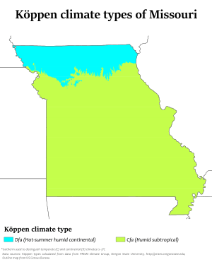
Missouri generally has a humid continental climate. This means it has cool, sometimes cold, winters and hot, humid, and wet summers. In the southern part of the state, especially in the Bootheel, the climate becomes humid subtropical.
Because Missouri is in the middle of the United States, it often has extreme temperatures. There are no high mountains or oceans nearby to make the temperatures milder. So, the weather is affected by cold air from the Arctic and hot, humid air from the Gulf of Mexico. Missouri's highest recorded temperature was 118 °F (48 °C) in Warsaw and Union on July 14, 1954. The lowest recorded temperature was -40 °F (-40 °C), also in Warsaw, on February 13, 1905.
Missouri is in Tornado Alley, so it often gets severe thunderstorms and tornadoes. On May 22, 2011, a very powerful EF-5 tornado hit Joplin. It killed 158 people and destroyed about one-third of the city. This tornado caused an estimated $1–3 billion in damages and injured over a thousand people. It was the deadliest tornado in the U.S. since 1947.
St. Louis and its suburbs have also had severe tornadoes. An EF4 tornado damaged Lambert-St. Louis International Airport on April 22, 2011. One of the worst tornadoes in American history hit St. Louis on May 27, 1896. It killed at least 255 people and caused a lot of damage.
| Monthly normal high and low temperatures for various Missouri cities in °F (°C). | |||||||||||||||
| City | Avg. | Jan | Feb | Mar | Apr | May | Jun | Jul | Aug | Sep | Oct | Nov | Dec | Year | |
|---|---|---|---|---|---|---|---|---|---|---|---|---|---|---|---|
| Columbia | High | 37 (3) |
44 (7) |
55 (13) |
66 (19) |
75 (24) |
84 (29) |
89 (32) |
87 (31) |
79 (26) |
68 (20) |
53 (12) |
42 (6) |
65.0 (18.3) |
|
| Columbia | Low | 18 (−8) |
23 (−5) |
33 (1) |
43 (6) |
53 (12) |
62 (17) |
66 (19) |
64 (18) |
55 (13) |
44 (7) |
33 (1) |
22 (−6) |
43.0 (6.1) |
|
| Kansas City | High | 36 (2) |
43 (6) |
54 (12) |
65 (18) |
75 (24) |
84 (29) |
89 (32) |
87 (31) |
79 (26) |
68 (20) |
52 (11) |
40 (4) |
64.4 (18.0) |
|
| Kansas City | Low | 18 (−8) |
23 (−5) |
33 (1) |
44 (7) |
54 (12) |
63 (17) |
68 (20) |
66 (19) |
57 (14) |
46 (8) |
33 (1) |
22 (−6) |
44.0 (6.7) |
|
| Springfield | High | 42 (6) |
48 (9) |
58 (14) |
68 (20) |
76 (24) |
85 (29) |
90 (32) |
90 (32) |
81 (27) |
71 (22) |
56 (13) |
46 (8) |
67.6 (19.8) |
|
| Springfield | Low | 22 (−6) |
26 (−3) |
35 (2) |
44 (7) |
53 (12) |
62 (17) |
67 (19) |
66 (19) |
57 (14) |
46 (8) |
35 (2) |
26 (−3) |
45.0 (7.2) |
|
| St. Louis | High | 40 (4) |
45 (7) |
56 (13) |
67 (19) |
76 (24) |
85 (29) |
89 (32) |
88 (31) |
80 (27) |
69 (21) |
56 (13) |
43 (6) |
66.2 (19.0) |
|
| St. Louis | Low | 24 (−4) |
28 (−2) |
37 (3) |
47 (8) |
57 (14) |
67 (19) |
71 (22) |
69 (21) |
61 (16) |
49 (9) |
38 (3) |
27 (−3) |
48.0 (8.9) |
|
| Source: | |||||||||||||||
Missouri's Rivers and Water Flow

All the water in Missouri eventually flows into the Mississippi River. Most of it goes into either the Mississippi River or the Missouri River within the state's borders. The Missouri River crosses the state, entering near Kansas City and leaving near St. Louis. It flows for about 430 miles (692 km) within Missouri. Only small amounts of water flow into the Mississippi outside the state through rivers like the St. Francis and White.
The larger rivers in the Ozark region are very interesting. Rivers like the White, Gasconade, and Osage have wide valleys in their upper parts and deep canyons in their lower parts. These rivers also have winding paths, called meanders, that are cut into the high land, not just on flat floodplains. This happened because the land slowly rose, and the rivers kept cutting downwards into the rock.
Many streams in Missouri are called "rivers" even if they are quite small. This is because of a direct translation from the French word "rivière," which means a stream smaller than a "fleuve" (a river that flows to the sea). For example, "Loutre River" comes from "Rivière Loutre," meaning "Otter Stream."
Missouri's Caves
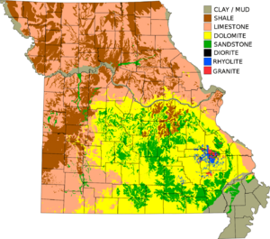
The Ozarks region has many karst features. This means the land is shaped by dissolving rock, creating lots of sinkholes, places where streams disappear underground, and many caves.
Caves are very common in and near the Ozark Mountain region in southwest Missouri. This is because the bedrock is made of limestone and dolomite, which dissolve easily. More than a hundred caves have been found in Stone County alone. Many others are in Christian, Greene, and McDonald counties.
Marvel Cave is located near the center of Stone County. The original entrance was a large sinkhole at the top of Roark Mountain, but now there's an easier way in. Marvel Cave has a huge room called the Auditorium. It's about 350 feet (107 meters) long and 125 feet (38 meters) wide. The ceiling is vaulted and rises from 100 to 295 feet (30 to 90 meters) high. At one end, there's a large stalagmite formation called the White Throne, which is about 65 feet (20 meters) tall and 200 feet (61 meters) around.
Jacobs Cavern, near Pineville, has revealed human and animal skeletons, along with old tools. Crystal Cave, near Joplin, has walls covered with shiny calcite crystals and other formations that are 1 to 2 feet (0.3 to 0.6 meters) long.
Other interesting caves include Friede's Cave near Rolla and Mark Twain Cave near Hannibal. Mark Twain Cave has a deep pool with many eyeless fish.
 | Lonnie Johnson |
 | Granville Woods |
 | Lewis Howard Latimer |
 | James West |


