
Kauai facts for kids
|
Nickname: The Garden Isle
|
|
|---|---|

March 2003 satellite photo
|
|

Location in Hawaiʻi
|
|
| Geography | |
| Coordinates | 22°04′12″N 159°29′51″W / 22.07000°N 159.49750°W |
| Area | 562.3 sq mi (1,456 km2) |
| Area rank | 4th largest Hawaiian Island |
| Highest elevation | 5,243 ft (1,598.1 m) |
| Highest point | Kawaikini |
| Administration | |
|
United States
|
|
| Symbols | |
| Flower | Mokihana (Melicope anisata) |
| Color | Poni (Purple) |
| Largest settlement | Kapaʻa |
| Demographics | |
| Demonym | Kauaian |
| Population | 73,298 (2020) |
| Pop. density | 118 /sq mi (45.6 /km2) |
Kauaʻi (pronounced kah-WAH-ee) is one of the main Hawaiian Islands. It's often called the "Garden Isle" because it's so green and full of nature.
Kauaʻi is about 562 square miles (1,456 km2) big. This makes it the fourth-largest Hawaiian island and the 21st-largest island in the United States. It's located about 73 miles (117 km) northwest of Oʻahu. In 2020, about 73,298 people lived on Kauaʻi.
The island is famous for its beautiful places like Waimea Canyon State Park and Na Pali Coast State Park. Kauaʻi is also the main part of Kauai County, which includes smaller nearby islands like Kaʻula, Lehua, and Niʻihau.
Contents
What's in a Name? The Story of Kauaʻi
The name Kauaʻi comes from an old Hawaiian story. It's said that a Polynesian explorer named Hawaiʻiloa discovered the Hawaiian Islands and named this island after his favorite son. One meaning for Kauaʻi could be "place around the neck," like how a father would carry his child. Another possible meaning is "food season."
Kauaʻi used to have its own special way of speaking the Hawaiian language. This unique dialect still exists on the island of Niʻihau. In the main Hawaiian dialect, there's no "t" sound, but the Kauaʻi dialect kept the old Polynesian "t" sound. So, people on Kauaʻi would have said "Tauaʻi" instead of "Kauaʻi," and "Tapaʻa" instead of "Kapaʻa."
A Look Back: Kauaʻi's History
People from Polynesia first settled on Kauaʻi many centuries ago. Digs show they arrived between 200 and 600 CE. These first settlers came from the Marquesas Islands. They lived peacefully for about 500 years until a second group arrived by sea-canoe from Tahiti. Many Hawaiian traditions and beliefs come from the culture brought by these Tahitian newcomers.
In 1778, Captain James Cook was the first European known to reach the Hawaiian islands. He landed at Waimea Bay and named the islands the "Sandwich Isles."
Kauaʻi and Niʻihau were the last islands to join King Kamehameha's Kingdom of Hawaiʻi. Their ruler, Kaumualiʻi, resisted Kamehameha for years. Kamehameha tried twice to invade with a huge fleet of ships, but failed both times due to a storm and then an illness. To avoid more fighting, Kaumualiʻi decided to join the kingdom peacefully in 1810. He became Kamehameha's helper and officially gave the island to the Kingdom of Hawaiʻi when he died in 1824.
Sugarcane Plantations
From the 1830s until the mid-1900s, sugarcane farms were the most important business on Kauaʻi. The first sugarcane farm started in 1835, and for the next 100 years, this industry was huge for Hawaiʻi's economy. Kauaʻi's last sugarcane farm, Gay & Robinson Plantation, stopped growing sugar in 2008 after 118 years.
Old Sugar Mill of Koloa
The Old Koloa Town opened a sugar mill in 1835. A man named John Mahiʻai Kāneakua worked there from 1906 to 1934. He was known for trying to help Queen Liliuokalani get her throne back after the U.S. took over Hawaiʻi in 1893.
Valdemar Knudsen: A Pioneer
Valdemar Emil Knudsen was a man from Norway who came to Kauaʻi in 1857. He first managed a farm called Grove Farm. Later, he bought land leases in Mana and Kekaha and became a very successful sugarcane farmer. He lived in Waiawa, right across from Niʻihau Island. His son, Eric Alfred Knudsen, was born there.
King Kamehameha made Knudsen a land administrator for a large area and gave him the title konohiki, which was like a noble position. Knudsen spoke Hawaiian very well and later became an important politician.
Hurricane Iniki
In 1992, Kauaʻi was hit by Hurricane Iniki, a very powerful storm. It caused a lot of damage to the island.
Exploring Kauaʻi's Geography


Kauaʻi is about five million years old, making it the oldest of the main Hawaiian islands. It was formed by a volcano as the Pacific Plate moved over a hot spot in the Earth. The island is basically an old volcano with a large crater and two smaller ones. Later, about 0.6 to 1.4 million years ago, new lava flows and cones covered the eastern two-thirds of the island.
The highest point on Kauaʻi is Kawaikini, which is 5,243 feet (1,598 meters) tall. The second-highest is Mount Waiʻaleʻale, located near the center of the island, at 5,148 feet (1,569 meters) above sea level. The east side of Mount Waiʻaleʻale is one of the wettest places on Earth, getting an average of 460 inches (11.7 meters) of rain each year! All this rain has carved deep valleys and canyons with many amazing waterfalls.
On the west side of the island, the town of Waimea sits at the mouth of the Waimea River. This river helped create Waimea Canyon, which is often called "The Grand Canyon of the Pacific." It's about 3,000 feet (914 meters) deep and is part of Waimea Canyon State Park. The Na Pali Coast is a remote area perfect for kayaking and hiking along its tall cliffs.
Kauaʻi's Climate
| Weather chart for Kauaʻi | |||||||||||||||||||||||||||||||||||||||||||||||
|---|---|---|---|---|---|---|---|---|---|---|---|---|---|---|---|---|---|---|---|---|---|---|---|---|---|---|---|---|---|---|---|---|---|---|---|---|---|---|---|---|---|---|---|---|---|---|---|
| J | F | M | A | M | J | J | A | S | O | N | D | ||||||||||||||||||||||||||||||||||||
|
31
22
16
|
110
22
14
|
99
24
15
|
34
24
15
|
37
24
17
|
4
25
18
|
11
26
18
|
27
25
18
|
15
24
19
|
35
24
18
|
27
23
18
|
107
21
17
|
||||||||||||||||||||||||||||||||||||
| temperatures in °C precipitation totals in mm |
|||||||||||||||||||||||||||||||||||||||||||||||
|
Imperial conversion
|
|||||||||||||||||||||||||||||||||||||||||||||||
Kauaʻi has a tropical climate, which means it's usually warm and humid all year. Sometimes, strong storms can cause big floods. Near the coast, the amount of rain changes a lot. The northeast side gets about 50 inches (127 cm) of rain each year, while the drier southwest side gets less than 20 inches (51 cm). The average temperature in Lihu'e, the main town, is about 78°F (26°C) in February and 85°F (29°C) in August and September.
The mountains on Kauaʻi are much cooler than the warm coastal areas. At Kōkeʻe State Park, which is high up, daytime temperatures range from about 45°F (7°C) in January to 68°F (20°C) in July. In winter, temperatures can even drop to the 30s and 40s (°F). The coldest unofficial temperature recorded there was 29°F (-2°C) in February 1986.
The mountainous parts of Kauaʻi get a lot of rain, usually between 50 and 100 inches (1,270-2,540 mm) each year. Mount Waiʻaleʻale, located about 10 miles (16 km) southeast of Kōkeʻe State Park, is often called the wettest spot on Earth. It averages around 374 inches (9.5 meters) of rain per year.
Kauaʻi also holds a record for how much rain can fall in just one hour. During a storm in January 1956, a rain gauge recorded 12 inches (30 cm) of rain in only 60 minutes!
Time Zone
Kauaʻi uses Hawaii Standard Time (UTC−10:00) all year. This means that when places on the mainland U.S. are using daylight saving time, Kauaʻi is three hours behind the West Coast and six hours behind the East Coast.
Rivers of Kauaʻi
- Waimea River (35.7 km)
- Hanalei River (26.5 km)
- Hanapēpē River (24.2 km)
- Wainiha River (24 km)
- Wailua River (23.4 km)
- Makaweli River (23.2 km)
- Huleia River (21.4 km)
- Kalihiwai River (20 km)
- Anahola River (19.4 km)
- Lumahaʻi River (16 km)
- Kōʻula River (14.8 km)
- Olokele River (14.4 km)
- Kilauea Stream (13.4 km)
- Waikomo Stream (9.8 km)
Beautiful Waterfalls
- Halii Falls
- Hanakapiai Falls
- Hinalele Falls
- Kalihiwai Falls
- Kilauea Falls
- Manawaiopuna Falls
- Opaekaa Falls
- Waialae Falls
- Wailua Falls
- Waipoo Falls
-
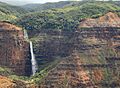
Waipoo Falls at Waimea Canyon State Park
-

Manawaiopuna Falls


Kauaʻi's Economy
Tourism is the biggest industry on Kauaʻi. In 2007, over 1.2 million people visited the island. Most visitors (84%) came from the United States, and 3% came from Japan. In 2003, there were about 27,000 jobs on Kauaʻi. The largest number of jobs were in hotels and restaurants (26%), followed by government (15%) and retail stores (14.5%). Farming made up a smaller part (2.9%) of jobs. The money visitors spend makes up about one-third of Kauaʻi's total income. Most businesses on the island are small, with 87% having fewer than 20 employees.

Kauaʻi has very rich soil, so farmers grow many kinds of fruits and other crops. You can find guava, coffee, mango, banana, papaya, avocado, star fruit, and pineapple grown here. However, most farmland is used for raising cattle.
Kauaʻi is also home to the U.S. Navy's "Barking Sands" Pacific Missile Range Facility on the western shore. This is a special place for testing missiles.
A radio station called WWVH is also on the west coast of Kauaʻi. It's operated by the U.S. National Institute of Standards and Technology and broadcasts exact time and frequency information to the public.
How Kauaʻi Gets Its Power
Kauaʻi Island Utility Cooperative (KIUC) is a company that provides electricity for the island. It's a not-for-profit cooperative, meaning it's owned by its 24,000 members who vote for a board of directors.
In the 1970s, Kauaʻi used to burn leftover sugarcane waste to make most of its electricity. By 2008, most of Kauaʻi's electricity came from burning imported liquid petroleum (oil).
However, by 2017, KIUC had made big changes! Their power came from 56% fossil fuels, 9% hydroelectric (water power), 12% biomass (burning plants), and 23% solar. During sunny hours, 97% or more of their electricity came from renewable sources like solar. KIUC even offers money back to people who install solar water heating systems on their homes.
In 2017, KIUC opened a large battery storage system next to a solar plant. This battery can store a lot of energy to use when the sun isn't shining. In 2018, they opened an even bigger solar and battery project.
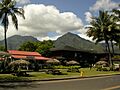
Towns and Communities on Kauaʻi
Līhuʻe, on the southeast coast, is the main town and the county seat of Kauaʻi. Kapaʻa, located about 6 miles (10 km) north of Līhuʻe, is the island's largest town with over 10,000 people. Princeville, on the north side, used to be the capital of Kauaʻi.
Here are some of the towns and villages on Kauaʻi and their populations:
| Name | population |
|---|---|
| Haʻena State Park | 550 |
| Wainiha | 419 |
| Hanalei | 450 |
| Princeville | 2,158 |
| Kalihiwai | 428 |
| Kilauea | 3,014 |
| Anahola | 2,311 |
| Kapaʻa | 11,652 |
| Wailua | 2,359 |
| Hanamāʻulu | 4,994 |
| Līhuʻe | 8,004 |
| Wailua Homesteads | 5,863 |
| Puhi | 3,380 |
| Poʻipū | 1,299 |
| Kōloa | 2,231 |
| Lāwaʻi | 2,578 |
| Kalāheo | 4,996 |
| ʻEleʻele | 2,515 |
| Hanapēpe | 2,678 |
| Kaumakani | 749 |
| Waimea | 2,057 |
| Kekaha | 3,715 |
| Pakala | 294 |
| Kealia | 103 |
-
Hanalei town with a view of Mt. Na Molokama
-
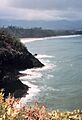
Northeastern coast of Kauaʻi, near Kīlauea
-
View of the Pacific Ocean, from the island's south shore
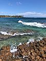
-
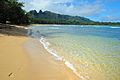
Anahola Bay is a great beach for snorkeling and swimming


Getting Around Kauaʻi: Transport
By Air

Lihue Airport is the only commercial airport on Kauaʻi, located on the southeast side. You can fly directly to Honolulu, Maui, Hawaii Island, the U.S. mainland, and Vancouver, Canada from here. There are also smaller airports for private planes, like Port Allen Airport and Princeville Airport.
By Road: Highways
Several state highways help you get around Kauaʻi:
- Hawaii Route 50, also called Kaumualiʻi Highway, runs for 33 miles (53 km) from Līhuʻe to the far western shore.
- Hawaii Route 58 is a short 2-mile (3.2 km) road in Līhuʻe.
- Hawaii Route 56, known as Kuhio Highway, goes for 28 miles (45 km) from Līhuʻe to Princeville.
- Hawaii Route 560 stretches 10 miles (16 km) from Princeville to Keʻe Beach in Haʻena State Park.
Other important highways connect different parts of the island:
- Hawaii Route 55 (7.6 miles / 12.2 km)
- Hawaii Route 550 (15 miles / 24 km)
- Hawaii Route 540 (4 miles / 6.4 km)
- Hawaii Route 530 (3.4 miles / 5.5 km)
- Hawaii Route 520 (5 miles / 8 km)
- Hawaii Route 570 (1 mile / 1.6 km)
- Hawaii Route 580 (5 miles / 8 km)
- Hawaii Route 581 (5 miles / 8 km)
- Hawaii Route 583 (3.9 miles / 6.3 km)
Hawaii Scenic Byway
The Holo Holo Koloa Scenic Byway is a special road that's over 19 miles (31 km) long. It connects many of Kauaʻi's historical and cultural spots, like the beautiful Tree Tunnel, Spouting Horn, and the Salt Beds.
Public Transportation
The Kauaʻi Bus is the public bus service that helps people get around Kauaʻi.
Cool Places to Visit on Kauaʻi


The Kauaʻi Heritage Center of Hawaiʻian Culture and the Arts was started in 1998. It helps people learn about and respect Hawaiian culture. You can take classes in Hawaiian language, hula dancing, making leis, and learn about Hawaiian traditions.
Here are some other interesting places to visit:
- Alakai Wilderness Area
- Allerton Garden
- Camp Naue YMCA
- Fern Grotto
- Haʻena State Park
- Hanalei Bay
- Hoʻopiʻi Falls
- Honopū Valley
- Kōkeʻe State Park
- Limahuli Garden and Preserve
- Makaleha Mountains
- Makauwahi Cave Reserve
- McBryde Garden
- Moir Gardens
- Moloaa Bay
- Na ʻĀina Kai Botanical Gardens
- Nā Pali Coast State Park
- ʻOpaekaʻa Falls
- Paoʻa Point
- Poipu Beach Park
- Polihale State Park
- Queen's Bath
- Sleeping Giant (Nounou Mountain)
- Spouting Horn
- Wailua River
- Waimea Canyon State Park
Panorama Gallery


Kauaʻi in Movies and TV
_Falls.jpg)
Kauaʻi has been a popular filming location for over 70 Hollywood movies and TV shows! Its beautiful scenery makes it perfect for many stories.
Some famous films shot here include:
- The musical South Pacific
- Disney's animated movie Lilo & Stitch and its sequels
- Jurassic Park (1993) and Jurassic World (2015) used Waimea Canyon
- Mighty Joe Young
- Raiders of the Lost Ark (opening scenes)
- Six Days Seven Nights
- King Kong (1976)
- Donovan's Reef (1963)
- Tropic Thunder
- Soul Surfer, a movie about Bethany Hamilton
- Just Go with It
- George of the Jungle
- Pirates of the Caribbean: On Stranger Tides
- A Perfect Getaway
Even Elvis Presley filmed parts of his movies Blue Hawaii (1961) and Paradise, Hawaiian Style (1966) on Kauaʻi, especially at the Coco Palms resort.
The 2011 film The Descendants, based on a novel by a Hawaiian writer, also had many scenes filmed on Kauaʻi.
Images for kids
-
Hanalei town with a view of Mt. Na Molokama, and Māmalahoa
-
Northeastern coast of Kauaʻi, near Kīlauea
-
View of the Pacific Ocean, from the island's south shore
-
Anahola Bay is a snorkeling and swimming beach with clear pools and a long coral reef
See also
 In Spanish: Kauai para niños
