
Humboldt Bay facts for kids
Quick facts for kids Humboldt Bay |
|
|---|---|

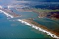
Aerial view of Humboldt Bay
and the City of Eureka |
|

Humboldt Bay
Location in California
|
|
| Location | Humboldt County, North Coast, California |
| Coordinates | 40°45′13.53″N 124°12′54.73″W / 40.7537583°N 124.2152028°W |
| Native name | Wigi (Wiyot) |
| River sources | Elk River; Jacoby, Freshwater, and Salmon Creeks. |
| Ocean/sea sources | Pacific |
| Basin countries | United States |
| Max. length | 14 miles (23 km) |
| Max. width | 4.5 miles (7 km) |
| Surface area | 13 square miles (34 km2)/25.5 square miles (66 km2) (min/max tide) (17,000 acres) |
| Average depth | 11 feet (3.4 m) |
| Max. depth | 40 feet (12 m) (dredged) |
| Islands | Tuluwat Island, Woodley Island, Daby Island |
| Settlements | Eureka, Arcata |
| Official name: Humboldt Harbor Historical District | |
| Reference #: | 882 |
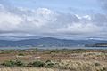
Humboldt Bay (Wiyot: Wigi) is a natural bay and a special type of coastal lagoon. It is found on the North Coast of California, in Humboldt County, United States.
It is the largest protected body of water on the West Coast between San Francisco Bay and Puget Sound. It is also the second-largest enclosed bay in California. Plus, it is the biggest port between San Francisco and Coos Bay, Oregon.
The main city next to the bay is Eureka, which is the county seat. The city of Arcata is also nearby. These cities and towns around Humboldt Bay are home to almost 80,000 people. This is about 60% of everyone living in Humboldt County.
Humboldt Bay is full of life! It has over 100 types of plants, 300 kinds of invertebrates (like crabs and worms), 100 fish species, and 200 bird species. The bay's marshes and grasses help hundreds of thousands of migrating and local shore birds.
For business, Humboldt Bay is very important for oyster production. It produces more than half of all the oysters farmed in California. The Port of Humboldt Bay is a deep water port. It has large docks that can handle big cargo ships. There are also marinas for smaller boats. In the past, the bay was used a lot to ship logs and wood products. Now, wood is shipped less often.
Contents
Geography of Humboldt Bay

Humboldt Bay is the only deep water bay between the San Francisco Bay and Coos Bay, Oregon. This makes it a very important protected port for large ships.
Even though it's the only safe harbor along about 500 miles (800 km) of coastline, European explorers didn't find it easily. It's hard to see from the ocean because of sandbars and frequent fog. The bay's entrance was also hard to spot.
Humboldt Bay started to form about 10,000 to 15,000 years ago. This happened when a river valley was covered by rising sea levels.
Three rivers used to flow into Humboldt Bay a long time ago. These were the Mad, Elk, and Eel rivers. Over time, the Mad River found a new way to the sea. The Eel River was moved by natural land changes. But the Elk River still flows into Humboldt Bay today.
Parts of the Bay

Today, Humboldt Bay is divided into three main areas:
- The North Bay, which is north of the Samoa Bridge.
- The Entrance Bay, from the Samoa Bridge to the South Jetty.
- The South Bay, which is the rest of the bay to the south.
There are three islands in the North Bay: Daby, Woodley, and Indian Island. All three are part of the City of Eureka. At low tide, two more islands appear: Bird Island and Sand Island. Sand Island was made from leftover material from dredging in the early 1900s. A large area of eelgrass in the South Bay is sometimes called Clam Island.
At high tide, the bay covers about 24 square miles (62 km²). At low tide, it shrinks to about 10.8 square miles (28 km²). With each tide cycle, 41% of the water in Humboldt Bay is replaced.
The bay is about 14 miles (23 km) long. Its width changes from about 0.5 miles (0.8 km) at the entrance to 4.3 miles (6.9 km) in the North Bay. The total surface area of Humboldt Bay is about 16,000 acres (65 km²). About 6,000 acres (24 km²) are mudflats that show at low tide. Over 5,000 acres (20 km²) are eelgrass habitats.
History of Humboldt Bay

Early explorers like Francis Drake and George Vancouver did not find Humboldt Bay. This was due to the bay's hidden entrance, storms, and fog.
Captain Jonathan Winship was the first to enter Humboldt Bay by sea in June 1806. He was working for the Russian-American Company. His group, including Aleuts in baidarkas hunting sea otters, faced resistance from local Native Americans. Winship's group named the bay Bay of Resanof.
In 1849, a group led by Josiah Gregg tried to find a land route to the Pacific Ocean. They walked from the gold town of Weaverville. The journey was slow because of thick redwood forests. They were very hungry when they reached the coast. They found what is now Humboldt Bay on December 20, 1849. After getting food, they went to San Francisco to share their discovery.
In March 1850, two ships, the General Morgan and the Laura Virginia, sailed to the bay from San Francisco. It was hard to get into the bay because of big waves and shifting sands. But the ships finally entered in 1850. The people from the Laura Virginia named the bay after Alexander von Humboldt. He was a famous German naturalist.
The local Wiyot people called the bay "Wike" or "Wiki." North of Eureka are three islands: Woodley Island, Daby Island, and Indian Island. Indian Island is a National Historic Landmark. It was also one of the places of the 1860 Wiyot Massacre.
The United States Coast Survey mapped Humboldt Bay in 1850. The map was published in 1852.
After two years of settlement in 1852, only six ships sailed from the bay to San Francisco. But by 1853, 143 ships full of lumber made the trip. Even with local pilots, 12 ships crashed on the sandbar. In bad weather, ships could be stuck in the harbor for weeks.
The first marker at the harbor entrance was put in place in 1853. The U.S. government paid for a lighthouse near the mouth. In 1856, the Humboldt Harbor Light was built. A bell boat was added in 1872, and later a steam whistle helped sailors in thick fog. The Humboldt Bay Life-Saving Station is also on the bay side of the North Spit.
By the 1880s, long docks were built for shipping lumber. Shipbuilding also became very important. The Bendrixson shipyards built 120 ships on Humboldt Bay. But many lives were lost. Eighty-one people drowned between 1853 and 1880 trying to cross the bar. Shipping reached about 600 vessels a year by 1881.
Humboldt Bay became an official port of entry in 1882. This allowed ships to sail directly to overseas ports. In 1886, the Table Bluff Light replaced the old Harbor Light after storms damaged it.
Engineering the Bay Entrance


The mouth of Humboldt Bay used to be a curved sandbar with breaking waves. Now, two sand spits protect the entrance: South Spit and North Spit. Jetties (long walls) were built from each spit to stabilize the bay mouth.
The South Spit jetty was started in 1889. But it caused erosion on the North Spit and made the channel wider. The jetties are about 6,000 feet (1,800 m) long and 2,200 feet (670 m) apart. Storms often damaged them, so they had to be rebuilt many times. Strong currents flow in and out of the entrance.
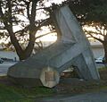
In 1971 and 1984, large concrete blocks called dolosse were added to make the jetties stronger. In 1972, 4,796 dolosse were made locally. Almost all of them are on the jetties. One was placed outside the Eureka Chamber of Commerce. This dolos was moved to Madaket Plaza in 2022. More dolosse were made in 1983. By 1985, over $20 million had been spent to protect the bay entrance.
In 1977, the jetties were named a California historical civil engineering landmark. In 1981, they became a national historical civil engineering landmark. The U.S. Army Corps of Engineers checks the jetties every year.
Dredging (removing sand and mud) of the channels began in 1881. This keeps the shipping channels deep enough for vessels. These changes have caused a lot of erosion at the bay's entrance. About 188 acres (0.76 km²) of Buhne Point, which used to block the bay entrance, washed away between 1854 and 1955.
Most of the large sloughs (small channels) around the bay have been protected with levees. But because of buildings and development, only about 10% of the original marsh habitat remains. Other marsh areas were lost to create land for farms or for building the Northwestern Pacific Railroad in 1901. This reduced the natural flow of tides, harming large marsh areas.
Ecology of Humboldt Bay

Humboldt Bay and its tidal sloughs are open for fishing all year. A protected area in the bay is the Humboldt Bay National Wildlife Refuge. It was created in 1971 to protect wetlands and bay habitats for migratory birds. The Humboldt Botanical Garden, near the bay, also protects local native plants. Humboldt Bay is also protected by the California Bays and Estuaries Policy.
In winter, over 100,000 birds use the bay for feeding and resting. These include different types of gulls, Caspian terns, brown pelicans, cormorants, surf scoters, and common murres.
The bay provides food for many saltwater fish, crustaceans (like crabs), and mollusks (like clams). Sport fishing is allowed. Dungeness crabs are caught for fun and for business. Oysters are also farmed in the bay.
The bay supports over 100 kinds of marine and estuarine fish. This includes green sturgeon, coho and Chinook salmon, steelhead, and coastal cutthroat trout. These fish spawn and grow in the bay's watershed, which covers 223 square miles (578 km²). Coho salmon mostly spawn in Elk River, Freshwater Creek, and Jacoby Creek. A recent study found that 40% of coho salmon in the area grow up in the bay's estuary. The federally endangered tidewater goby lives in the bay, along with other common fish.
The bay has been invaded by the European green crab. This crab eats young native crabs, mussels, oysters, and clams. European green crabs were first seen in Humboldt Bay in 1995. They are thought to be why clam harvesting has gone down. Scientists have not found a way to control them.

Marine mammals found here include harbor porpoises, harbor seals, California sea lions, and river otters. Steller sea lions and gray whales are seen just offshore. Leopard sharks have been reported inside the bay. The bay also provides a home for young bat rays, which eat clams, crabs, shrimp, and worms.
Bay Settlements


About 80,000 people live around Humboldt Bay. There are at least 20 named towns and communities on the flat land around the bay. Most of these are smaller areas near the City of Eureka.
Here are some of the places located on or near the bay, listed clockwise from the north side of the bay entrance:
Bay Tributaries and Sloughs
_May_2012.JPG)
Many streams and sloughs (small channels) flow into Humboldt Bay. They are listed from north to south, clockwise. The main streams from large watershed areas east of the bay are in bold. These watersheds cover a total area of 288 square miles (746 km²).
- Mad River Slough
- Liscom Slough
- Janes Creek (becomes McDaniels Slough)
- Jolly Giant Creek (becomes Butcher Slough)
- Campbell Creek (partially goes to Gannon Slough)
- Fickle Hill Creek
- Gannon Slough
- Grotzman Creek
- Beith Creek
- Little Jacoby Creek
- Jacoby Creek
- Washington Gulch Creek
- Rocky Gulch Creek
- Eureka Slough
- Fay Slough
- Cochran Creek
- Freshwater Creek
- Little Freshwater Creek
- Ryan Slough
- Ryan Creek
- First Slough
- Second Slough
- Third Slough
- Fay Slough
- Clarke Slough
- Elk River
- Swain Slough
- Martin Slough
- Swain Slough
- Willow Brook/White Slough
- Salmon Creek
- Deering Creek
- Little Salmon Creek
- Hookton Slough
Harbor Management
The Humboldt Bay Harbor Recreation and Conservation District manages Humboldt Bay and its ports. Even with the jetties and dredging, the harbor entrance can still be tricky. Only trained maritime pilots from the district are allowed to bring large ships into the bay.
The Humboldt Bay District also manages a 237-berth marina at Woodley Island. This marina serves both fun boats and commercial boats. There is also a shipping dock in South Bay.
Dangerous sand bars and strong currents have caused many shipwrecks at the entrance to Humboldt Bay. This was especially true in the late 1800s. Forty-two ships crashed in or near the channel. Most of these were being pulled by a tug boat. Fifty-four ships crashed along the Humboldt County coastline. Most shipwrecks happened between 1850 and 1899.
Humboldt Bay National Wildlife Refuge
The Humboldt Bay National Wildlife Refuge was created in 1971. Its goal is to save and protect many different habitats. These habitats are home to mammals, migratory birds, fish, amphibians, and plants. In total, the refuge covers 3,000 acres (12 km²). It includes parts of the cities and towns of Loleta, Eureka, and Arcata.
Restoration Projects
Salmon Creek Restoration
Humboldt Bay has many different tributaries, which are smaller rivers or streams flowing into it. Salmon Creek is the third largest tributary. As its name suggests, Salmon Creek used to have many coho salmon, steelhead trout, and chinook salmon. In recent years, the coho salmon population in California has been decreasing. This is due to things like damaged freshwater habitats and water being taken for farms and cities.
Historically, Salmon Creek had tidal salt marshes with many sloughs. But in the 1900s, overgrazing, building levees, and putting in tide gates badly damaged Salmon Creek. The Humboldt Bay NWR bought the land in 1988. They decided Salmon Creek needed restoration to improve its estuary habitats.
Phase 1 of the restoration began in 2006. The goal was to improve tidal flow, build new tide gates, and connect old ponds to the stream. Phase 1 helped the habitat and fish movement a little. But more work was needed.
Phase 2 of restoration added 4,200 feet (1,280 m) of new estuary channels and habitat. Over 200 logs were also added to the channels and sloughs. These logs provide places for marine life to hide and rest. One year after Phase 2 was finished, the California Department of Fish and Game did a survey. They found more young coho salmon than the year before.
Lanphere Dunes Restoration
The Lanphere Dunes restoration project is considered the first of its kind on the west coast. The Lanphere Dunes are part of the Humboldt Bay National Wildlife Refuge. They are home to many unique plants and animals.
Restoration efforts started in 1980. The goal was to stop the spread of an invasive plant called European Beachgrass. The Lanphere Dunes were originally lived in by the Wiyot people. In the 1930s, William and Hortense Lanphere became the new landowners. Along with European Beachgrass, another invasive plant, Yellow Bush Lupine, was also introduced from a nearby property.
Dune restoration can be hard. This is because all the plants and animals have adapted to the special coastal conditions. Dunes are a tough environment. They have poor soil, summer droughts, ocean spray, strong winds, and intense sunlight. Because of these conditions, using machines is best for this type of project.
Mechanical restoration began by removing European Beachgrass by hand or with shovels. This plant has strong roots, so it needs to be removed many times over several years. This method also allows native plants to grow back at their own pace. The first restoration project started over 40 years ago. Today, native plant and animal communities are doing very well.
Images for kids
-
Aerial view of Humboldt Bay and the City of Eureka
-
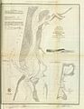
1852 U.S. Coast Survey map of Humboldt Bay.
-
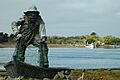
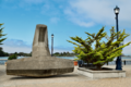
View of the Middle Channel of Humboldt Bay and Indian Island taken on Woodley Island. Note the Memorial to lost fisherman in the foreground.
-
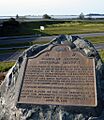
The Humboldt Harbor Historical District is California Historical Landmark #882
-
One of the 4,796 dolosse made on the South Spit for use on the south and north jetties protecting the mouth of Humboldt Bay.
-
The donated dolos after it was moved to Madaket Plaza in 2022.
-
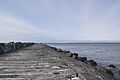
Table Bluff Beach offers views of the South Spit Jetty. Fishermen are often seen fishing.
-
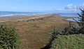
Mike Thompson Wildlife Area is a 4.5 mi-long stretch of beach, dunes and tidal marsh that serves as a popular destination for waterfowl hunting, surf fishing, and clamming on the south spit of Humboldt Bay
-
A close up view of the Mike Thompson Wildlife Area located on Table Bluff Beach in Loleta, California
-
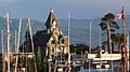
Easterly view from the docks of Eureka's Woodley Island Marina. Carson Mansion at dusk, with distant view of California Coast Ranges due east of the populated Humboldt Bay area.
-
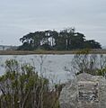
Northerly view from Woodley Island of Monterey cypress trees on Tuluwat Island, the largest of three islands, all of which are in the Eureka City limits. The great egret nests in these trees in large numbers each year.
-
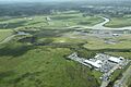
Southerly view of Eureka Slough (left and midsection, larger stream), Freshwater Slough (right-mid portion, larger stream); and when photo is expanded Freshwater Creek (background and left near treeline), Ryan Slough (mid-upper top portion), Ryan Creek (furthest top midsection and barely visible when photo is expanded). Location is South of Highway 101 at the northern edge of the city of Eureka.

See also
 In Spanish: Bahía de Humboldt para niños
