Lake Erie Basin facts for kids
The Lake Erie Basin is a large area of land that includes Lake Erie and all the surrounding land where water flows into the lake. These areas are often named after the rivers or streams that carry water into Lake Erie.
This basin covers parts of several states in the United States: Indiana, Michigan, New York, Ohio, and Pennsylvania. It also includes a part of Ontario in Canada. The Lake Erie Basin is connected to the larger Great Lakes Basin and the Saint Lawrence River Watershed, which eventually flows into the Atlantic Ocean.
Most of the water in Lake Erie, about 80%, comes from the Detroit River. Only about 9% comes from all the other rivers and streams combined. The rest (11%) comes directly from rain and snow falling onto the lake. The shallow areas near the shore, where the lake is less than 15 feet (4.6 m) deep, are called the littoral zone. This is where the land meets the lake.
Contents
How the Lake Erie Basin Was Formed
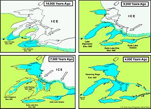
The Lake Erie Basin was created a very long time ago, at the end of the Wisconsin glaciation. This was a period when huge sheets of ice, called glaciers, covered much of North America. As the glaciers melted and moved, they carved out the land, forming the Great Lakes.
At first, the basin was part of a much larger ancient lake called Glacial Lake Maumee. But then, a new path for water opened up to the east at the Niagara River. This caused the water from the Maumee River to change direction and flow eastward instead. The Great Black Swamp, a large wetland area, is believed to be a leftover part of that ancient glacial lake.
Geography of the Lake Erie Basin
The Lake Erie Basin stretches across several states and one Canadian province. Each area has many rivers and streams that contribute water to the lake.
Indiana's Waterways
In Indiana, the main part of the Lake Erie Basin is the Maumee Watershed. This area includes counties like Adams, Allen, and DeKalb. Key rivers here include the Maumee River itself, the St. Joseph River, and the St. Mary's River. These rivers eventually join the Maumee River, which flows into Lake Erie.
Michigan's Rivers and Streams
Michigan contributes a large area of about 5,808 square miles (15,040 km2) to the Lake Erie Basin. Many rivers in Michigan flow into the lake. Some important ones are the Belle River, the Black River, and the Clinton River.
The Detroit River is also a major part of Michigan's basin, and it's very important for Lake Erie. Other rivers like the Ecorse River and River Rouge also flow into the Detroit River. The Huron River and the River Raisin are other significant waterways in Michigan that drain into Lake Erie.
New York's Contribution
New York's part of the Lake Erie Basin covers about 2,300 square miles (6,000 km2). The Buffalo River watershed is a key area, including Buffalo Creek and its branches.
Another important waterway is Cattaraugus Creek, which flows through several counties before reaching Lake Erie. The Chautauqua Creek area also has many smaller streams like Beaver Creek and Silver Creek that empty into the lake.
Ohio's Lake Erie Connections
Ohio has a large portion of the Lake Erie Basin. Many rivers here are vital for the lake's health. The Ashtabula River and Chagrin River are part of the Ashtabula-Chagrin Watershed. The Auglaize River and its tributary, the Ottawa River, are also important.
The Black River and Rocky River flow through central Ohio counties. The Blanchard River is another significant waterway. In the Cedar-Portage Watershed, you'll find rivers like Portage River and Toussaint River. The Conneaut Creek also flows from Ohio into Lake Erie.
The Cuyahoga River and Grand River are well-known rivers in Ohio that are part of the basin. The Huron River and Vermilion River are also key. The Maumee River watershed is very large, covering many counties in Ohio and extending into Michigan. Finally, the Sandusky River is another major river in Ohio that drains into Lake Erie.
Pennsylvania's Waterways
In Pennsylvania, the Lake Erie Basin includes parts of Erie and Crawford counties. The Ashtabula River and Conneaut Creek watersheds extend into Pennsylvania. Other smaller streams like Turkey Creek also contribute water to Lake Erie from this state.
Ontario's Basin Area
In Canada, the province of Ontario has a significant part of the Lake Erie Basin. The Detroit River watershed is shared with Michigan and includes important rivers like the Avon River and the Thames River. Lake St. Clair and the St. Clair River are also part of this system, connecting Lake Huron to Lake Erie.
Other important rivers in Ontario that flow into Lake Erie include Big Otter Creek, Clear Creek, and Long Point Creek. The Big Creek and Lynn River are also part of the basin.
The Grand River watershed is the largest drainage area in southern Ontario, covering about 2,600 square miles (7,000 km²). It has several important branches like the Conestogo River, Eramosa River, Nith River, and Speed River.
Why the Lake Erie Basin is Important
The Lake Erie Basin is important for many reasons, including its economy. However, human activities can cause pollution. Farming, factories, and homes are the main sources of pollution in the Lake Erie Basin.
Environmental agencies work hard to keep the lake clean because its fresh water is used for drinking, fun activities like swimming and boating, and for fishing. Pollution can cause problems like too much silt and sediment, which might need to be removed by dredging.
Fertilizers from farms and homes, along with untreated water from sewage plants, can lead to too many nutrients in the lake. This can cause algae blooms and other issues that harm the lake's health. Factories can also release metals that contaminate the lake's sediments. Protecting the Lake Erie Basin means protecting a vital resource for both people and wildlife.
 | Precious Adams |
 | Lauren Anderson |
 | Janet Collins |


