LeFlore County, Oklahoma facts for kids
Quick facts for kids
LeFlore County
|
|
|---|---|

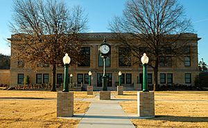
LeFlore County Courthouse in Poteau
|
|

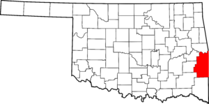
Location within the U.S. state of Oklahoma
|
|
 Oklahoma's location within the U.S. |
|
| Country | |
| State | |
| Founded | 1907 |
| Named for | An influential Choctaw Indian family |
| Seat | Poteau |
| Largest city | Poteau |
| Area | |
| • Total | 1,609 sq mi (4,170 km2) |
| • Land | 1,589 sq mi (4,120 km2) |
| • Water | 19 sq mi (50 km2) 1.2%% |
| Population
(2020)
|
|
| • Total | 48,129 |
| • Density | 29.912/sq mi (11.549/km2) |
| Time zone | UTC−6 (Central) |
| • Summer (DST) | UTC−5 (CDT) |
| Congressional district | 2nd |
LeFlore County is a county located in the eastern part of Oklahoma, USA. It sits right on the border with Arkansas. In 2020, about 48,129 people lived here.
The main town and county seat is Poteau. LeFlore County is part of the larger Fort Smith metropolitan area. The county got its name from a well-known Choctaw family called LeFlore.
History
Early Choctaw Land
The Choctaw Nation signed a special agreement, the Treaty of Doak's Stand, in 1820. This agreement gave them a large piece of land in what was then called Indian Territory. They gave up some of their old lands in the southeastern United States.
Later, in 1830, they signed another agreement, the Treaty of Dancing Rabbit Creek. This meant they gave up the rest of their original homeland. Many Choctaw people were then moved to Indian Territory by the U.S. military. This move happened in several stages.
Skullyville and Fort Coffee
In 1832, the U.S. government built the Choctaw Agency. This was about 15 miles (24 km) west of Fort Smith, Arkansas. The town of Skullyville grew up around this agency.
Skullyville became important. It was the county seat for Skullyville County. It was also the capital of the Moshulatubbee District and the main capital for the Choctaw Nation. U.S. Indian agents lived in Skullyville. In the late 1850s, it became a stop for the Butterfield Overland Mail route, which carried mail and passengers.
In 1834, the U.S. Army built Fort Coffee near Skullyville. The army left after four years. The Methodist Church then used the fort as a school for boys, called the Fort Coffee Academy. In 1845, they also started the New Hope Seminary for Girls. The Choctaw Agency building burned down in 1847. Its work moved to Fort Washita.
Civil War and After
During the American Civil War, the Choctaw people sided with the Confederacy. Many Choctaw men joined the Confederate army. A battle called the Battle of Devil's Backbone happened near Pocola in 1863. Union troops burned the Fort Coffee Academy because Confederate soldiers were using it.
After the war, in 1866, the Choctaw government reopened New Hope Seminary. However, they never rebuilt the boys' academy. New Hope Seminary operated until it burned down in 1896. Schools for Choctaw freedmen (formerly enslaved people) also opened in the area.
Railroads and Development
Starting in 1886, the county saw a lot of railroad building. This was because of the growing coal mining and timber industries. Railroads helped move these products.
Many different railroad companies built lines through the county. These lines connected towns like Wister, Howe, and Shady Point. They also linked LeFlore County to Arkansas and other parts of Oklahoma. These railroads were very important for the county's growth and economy.
Modern History
Before Oklahoma became a state, LeFlore County was part of the Choctaw Nation's districts. These included Nashoba, Skullyville, Sugar Loaf, and Wade counties.
Robert S. Kerr was a former Governor and U.S. Senator from Oklahoma. In the 1950s, he started a ranch near Poteau. In 1978, his family gave this ranch to the state. It is now the Kerr Conference Center and Museum. Other related places like the Kerr Center for Sustainable Agriculture are also in the county.
Geography
LeFlore County covers a total area of about 1,609 square miles (4,167 km²). Most of this, about 1,589 square miles (4,116 km²), is land. The remaining 19 square miles (49 km²) is water.
Rivers and Mountains
The Arkansas River forms the northern edge of the county. Other rivers like the Poteau and James Fork flow into the Arkansas River. The Kiamichi, Little, and Mountain Fork rivers flow south into the Red River of the South.
The Ouachita Mountains stretch into the southern part of the county. Other mountain ranges here include the Winding Stair Mountains and the Kiamichi Mountains. Cavanal Hill is also partly in the northern part of the county.
Natural Attractions
Lake Wister is a large lake in the middle of the county. It helps control floods. The Ouachita National Forest covers the southern half of the county. Both Lake Wister and the forest are popular places for visitors.
Heavener Runestone State Park is another interesting spot. It features a large stone with mysterious carvings. The Winding Stair Mountain National Recreation Area is also in LeFlore County. It is one of only two National Recreation Areas in Oklahoma.
Major Highways
 U.S. Highway 59
 U.S. Highway 259
 U.S. Highway 270
 U.S. Highway 271
 State Highway 1
 State Highway 9
 State Highway 31
 State Highway 63
Adjacent Counties
- Sequoyah County (north)
- Sebastian County, Arkansas (northeast)
- Scott County, Arkansas (east)
- Polk County, Arkansas (southeast)
- McCurtain County (south)
- Pushmataha County (southwest)
- Latimer County (west)
- Haskell County (northwest)
National Protected Areas
- Indian Nations National Wildlife and Scenic Area
- Ouachita National Forest (part)
- Winding Stair Mountain National Recreation Area
- Spiro Mounds
Population Data
| Historical population | |||
|---|---|---|---|
| Census | Pop. | %± | |
| 1910 | 29,127 | — | |
| 1920 | 42,765 | 46.8% | |
| 1930 | 42,896 | 0.3% | |
| 1940 | 45,866 | 6.9% | |
| 1950 | 35,276 | −23.1% | |
| 1960 | 29,106 | −17.5% | |
| 1970 | 32,137 | 10.4% | |
| 1980 | 40,698 | 26.6% | |
| 1990 | 43,270 | 6.3% | |
| 2000 | 48,109 | 11.2% | |
| 2010 | 50,384 | 4.7% | |
| 2020 | 48,129 | −4.5% | |
|
|||
In 2000, there were 48,109 people living in LeFlore County. This included 17,861 households and 13,199 families. The population density was about 30 people per square mile (12 people per km²).
About 33.4% of households had children under 18 living with them. Many households were married couples living together (58.5%). The average household had about 2.61 people.
The population included people of different ages. About 26.1% were under 18 years old. About 13.8% were 65 years or older. The average age in the county was 36 years.
Communities
Cities
Towns
Census-designated places
Other unincorporated communities
- Big Cedar
- Milton
- Muse
- Octavia
- Page
- Skullyville
Historic Places
Many places in LeFlore County are listed on the National Register of Historic Places. This means they are important historical sites.
|
|
See also
 In Spanish: Condado de Le Flore para niños

