List of pillars in Montana facts for kids
Montana is a state in the western United States known for its amazing natural beauty, including towering mountains, vast plains, and unique rock formations. Among these natural wonders are many tall, standalone rock structures called pillars. These pillars are like natural sculptures, carved over millions of years by wind, water, and ice. They often have interesting shapes and names, and some even hold historical importance.
Contents
What are Rock Pillars?
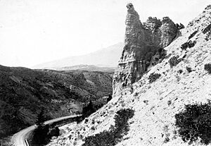
A rock pillar is a tall, narrow, and often isolated rock formation. Think of them as natural towers made of stone. They are usually formed through a process called erosion. This happens when softer rock around a harder rock wears away over time due to weather. Imagine water, wind, and even ice slowly chipping away at a large rock formation. If there's a section of rock that's tougher or more resistant to this wearing down, it will remain standing while the surrounding, weaker rock disappears. This leaves behind a tall, pillar-like structure.
Many pillars in Montana are made of sandstone or other sedimentary rocks. These rocks are formed from layers of sand, mud, and other materials that have been pressed together over millions of years. Different layers can have different hardness, which helps create the unique shapes of these pillars.
Famous Pillars in Montana
Montana is home to at least 73 named rock pillars, each with its own story or unique appearance. Some are well-known landmarks, while others are hidden gems in the vast landscape.
Pompey's Pillar
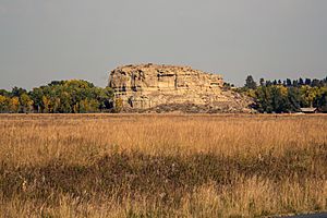
One of the most famous pillars is Pompey's Pillar in Yellowstone County. This isn't just a cool rock; it's a piece of history! In 1806, the famous explorer William Clark of the Lewis and Clark Expedition carved his name and the date into the rock. This makes it the only remaining physical evidence of the expedition along the entire trail. It's named after Sacagawea's son, Jean Baptiste Charbonneau, who Clark nicknamed "Pomp."

Other Interesting Pillars
Many other pillars in Montana have names that describe their appearance or local legends:
- Chimney Rock: Several pillars across Montana are called Chimney Rock because they resemble tall, narrow chimneys.
- Castle Rock: You'll find multiple "Castle Rocks" that look like ancient castles or fortresses, complete with turrets and walls.
- Eagle Nest Rock: This pillar, found in Park County, might have been a nesting spot for eagles, giving it its name.
- Elephant Rock: Located in Meagher County, this formation looks like a giant elephant, showcasing how erosion can create amazing shapes.
- Barking Dog: In Lewis and Clark County, there's a pillar named Barking Dog, which must have a shape that reminds people of a canine friend.
These natural monuments are not only beautiful but also important for understanding the geology and history of Montana. They remind us of the incredible power of nature and the long history of the land.
List of Named Pillars in Montana
Here is a list of some of the many named rock pillars found across Montana, along with their locations and elevations:
- Alcatraz Rock, Fallon County, Montana, 46°03′18″N 104°28′12″W / 46.05500°N 104.47000°W, el. 3,396 feet (1,035 m)
- Alp Rock, Park County, Montana, 45°05′14″N 109°54′04″W / 45.08722°N 109.90111°W, el. 9,793 feet (2,985 m)
- Baker Monument, Fergus County, Montana, 47°40′59″N 108°58′27″W / 47.68306°N 108.97417°W, el. 3,081 feet (939 m)
- Barking Dog, Lewis and Clark County, Montana, 46°48′27″N 111°38′02″W / 46.80750°N 111.63389°W, el. 5,426 feet (1,654 m)
- Bear Tooth, Liberty County, Montana, 48°49′34″N 111°07′07″W / 48.82611°N 111.11861°W, el. 4,790 feet (1,460 m)
- Big Rock, Glacier County, Montana, 48°26′32″N 113°04′05″W / 48.44222°N 113.06806°W, el. 4,793 feet (1,461 m)
- Black Rock, Chouteau County, Montana, 47°39′30″N 110°22′37″W / 47.65833°N 110.37694°W, el. 3,340 feet (1,020 m)
- Castle Rock, Powell County, Montana, 46°32′11″N 112°39′49″W / 46.53639°N 112.66361°W, el. 5,686 feet (1,733 m)
- Castle Rock, Pondera County, Montana, 48°10′11″N 112°13′33″W / 48.16972°N 112.22583°W, el. 4,035 feet (1,230 m)
- Castle Rock, Park County, Montana, 45°19′20″N 110°33′43″W / 45.32222°N 110.56194°W, el. 6,709 feet (2,045 m)
- Castle Rock, Carter County, Montana, 46°02′27″N 104°27′47″W / 46.04083°N 104.46306°W, el. 3,445 feet (1,050 m)
- Castle Rock Spire, Carbon County, Montana, 45°05′50″N 109°38′35″W / 45.09722°N 109.64306°W, el. 12,539 feet (3,822 m)
- Castle Rocks, Phillips County, Montana, 47°49′39″N 107°27′00″W / 47.82750°N 107.45000°W, el. 3,054 feet (931 m)
- Castle Rocks, Big Horn County, Montana, 45°20′05″N 108°32′42″W / 45.33472°N 108.54500°W, el. 5,810 feet (1,770 m)
- Chimney Rock, Carter County, Montana, 45°30′34″N 104°17′14″W / 45.50944°N 104.28722°W, el. 3,802 feet (1,159 m)
- Chimney Rock, Dawson County, Montana, 47°30′39″N 104°32′48″W / 47.51083°N 104.54667°W, el. 2,303 feet (702 m)
- Chimney Rock, Park County, Montana, 45°03′21″N 109°57′11″W / 45.05583°N 109.95306°W, el. 10,216 feet (3,114 m)
- Chimney Rock, Powder River County, Montana, 45°26′36″N 106°01′54″W / 45.44333°N 106.03167°W, el. 3,770 feet (1,150 m)
- Chimney Rock, Park County, Montana, 45°31′58″N 110°46′36″W / 45.53278°N 110.77667°W, el. 7,480 feet (2,280 m)
- Citadel Rock, Chouteau County, Montana, 47°49′55″N 110°04′26″W / 47.83194°N 110.07389°W, el. 2,566 feet (782 m)
- Cleft Rock, Flathead County, Montana, 48°55′02″N 114°31′37″W / 48.91722°N 114.52694°W, el. 7,142 feet (2,177 m)
- Crow Rock, Garfield County, Montana, 46°57′21″N 106°07′07″W / 46.95583°N 106.11861°W, el. 2,700 feet (820 m)
- Cupids Heart, Gallatin County, Montana, 45°24′38″N 110°56′57″W / 45.41056°N 110.94917°W, el. 8,809 feet (2,685 m)
- Dog Tooth Rock, Park County, Montana, 45°12′44″N 110°58′29″W / 45.21222°N 110.97472°W, el. 7,739 feet (2,359 m)
- Dutch Oven, Garfield County, Montana, 46°54′41″N 107°46′54″W / 46.91139°N 107.78167°W, el. 3,123 feet (952 m)
- Eagle Nest Rock, Park County, Montana, 45°00′40″N 110°41′37″W / 45.01111°N 110.69361°W, el. 5,499 feet (1,676 m)
- Eagle Rock, McCone County, Montana, 47°32′20″N 106°05′23″W / 47.53889°N 106.08972°W, el. 2,654 feet (809 m)
- Eagle Rock, Chouteau County, Montana, 47°51′41″N 110°03′47″W / 47.86139°N 110.06306°W, el. 2,572 feet (784 m)
- Eagle Rock, Beaverhead County, Montana, 45°42′24″N 113°01′53″W / 45.70667°N 113.03139°W, el. 6,568 feet (2,002 m)
- Eglise Rock, Madison County, Montana, 45°12′22″N 111°25′36″W / 45.20611°N 111.42667°W, el. 9,485 feet (2,891 m)
- Elephant Rock, Meagher County, Montana, 46°37′51″N 110°29′26″W / 46.63083°N 110.49056°W, el. 6,447 feet (1,965 m)
- Goat Rocks, Sanders County, Montana, 48°08′04″N 115°43′33″W / 48.13444°N 115.72583°W, el. 4,242 feet (1,293 m)
- Goose Rock, Missoula County, Montana, 46°56′52″N 113°34′37″W / 46.94778°N 113.57694°W, el. 3,527 feet (1,075 m)
- Haystack Butte, Chouteau County, Montana, 48°00′01″N 111°10′08″W / 48.00028°N 111.16889°W, el. 3,560 feet (1,090 m)
- History Rock, Gallatin County, Montana, 45°29′30″N 110°59′44″W / 45.49167°N 110.99556°W, el. 6,798 feet (2,072 m)
- Indian Head Rock, Jefferson County, Montana, 46°16′08″N 112°18′34″W / 46.26889°N 112.30944°W, el. 5,676 feet (1,730 m)
- Indian Head Rock, Cascade County, Montana, coordinates unknown, el. 3,425 feet (1,044 m)
- Indian Rock, Fergus County, Montana, 47°04′29″N 109°36′18″W / 47.07472°N 109.60500°W, el. 4,058 feet (1,237 m)
- Jones Cone, Fergus County, Montana, 47°40′10″N 109°27′05″W / 47.66944°N 109.45139°W, el. 2,762 feet (842 m)
- LaBarge Rock, Chouteau County, Montana, 47°54′40″N 110°03′42″W / 47.91111°N 110.06167°W, el. 2,648 feet (807 m)
- Mil-mil-teh Hill, Meagher County, Montana, 46°53′57″N 111°31′44″W / 46.89917°N 111.52889°W, el. 6,821 feet (2,079 m)
- Napi Rock, Glacier County, Montana, 48°44′51″N 113°29′25″W / 48.74750°N 113.49028°W, el. 7,474 feet (2,278 m)
- Needle Butte, Rosebud County, Montana, 46°47′23″N 106°37′20″W / 46.78972°N 106.62222°W, el. 3,251 feet (991 m)
- Peyton Rock, Ravalli County, Montana, 45°44′56″N 114°25′59″W / 45.74889°N 114.43306°W, el. 5,650 feet (1,720 m)
- Pikes Peak, Valley County, Montana, 48°47′36″N 106°35′58″W / 48.79333°N 106.59944°W, el. 3,097 feet (944 m)
- Pilot Rock, Chouteau County, Montana, 47°58′27″N 110°06′10″W / 47.97417°N 110.10278°W, el. 2,526 feet (770 m)
- Pipe Organ Rock, Beaverhead County, Montana, 45°04′02″N 112°48′14″W / 45.06722°N 112.80389°W, el. 5,479 feet (1,670 m)
- Point Stupid, Park County, Montana, 45°24′42″N 110°48′51″W / 45.41167°N 110.81417°W, el. 7,802 feet (2,378 m)
- Point of Rocks, Flathead County, Montana, 48°38′40″N 114°43′22″W / 48.64444°N 114.72278°W, el. 3,412 feet (1,040 m)
- Pompeys Pillar, Yellowstone County, Montana, 45°59′43″N 108°00′19″W / 45.99528°N 108.00528°W, el. 3,005 feet (916 m)
- Prohibition Rock, Gallatin County, Montana, 45°07′32″N 111°13′03″W / 45.12556°N 111.21750°W, el. 7,887 feet (2,404 m)
- Proposal Rock, Beaverhead County, Montana, 45°38′06″N 113°21′19″W / 45.63500°N 113.35528°W, el. 7,598 feet (2,316 m)
- Pulpit Rock, Gallatin County, Montana, 45°05′00″N 111°12′43″W / 45.08333°N 111.21194°W, el. 6,880 feet (2,100 m)
- Pumpelly Pillar, Glacier County, Montana, 48°28′29″N 113°27′02″W / 48.47472°N 113.45056°W, el. 7,457 feet (2,273 m)
- Red Rock, Missoula County, Montana, 46°56′28″N 113°35′24″W / 46.94111°N 113.59000°W, el. 3,566 feet (1,087 m)
- Road Agents Rock, Beaverhead County, Montana, 45°11′48″N 112°58′12″W / 45.19667°N 112.97000°W, el. 6,667 feet (2,032 m)
- Sand Rocks, Blaine County, Montana, 48°17′56″N 109°09′47″W / 48.29889°N 109.16306°W, el. 3,707 feet (1,130 m)
- Sentinel Rock, Lewis and Clark County, Montana, 47°00′21″N 112°03′35″W / 47.00583°N 112.05972°W, el. 3,563 feet (1,086 m)
- Sheep Rock, Gallatin County, Montana, 45°28′42″N 111°15′58″W / 45.47833°N 111.26611°W, el. 5,882 feet (1,793 m)
- Sheep Rock, Jefferson County, Montana, 45°55′16″N 112°00′01″W / 45.92111°N 112.00028°W, el. 5,433 feet (1,656 m)
- Ship Rock, Chouteau County, Montana, 47°52′19″N 110°02′40″W / 47.87194°N 110.04444°W, el. 2,789 feet (850 m)
- Signal Rock, Granite County, Montana, 46°08′40″N 113°46′47″W / 46.14444°N 113.77972°W, el. 7,638 feet (2,328 m)
- Square Butte, Phillips County, 47°43′42″N 108°35′46″W / 47.72833°N 108.59611°W, el. 3,048 feet (929 m)
- Stack Rocks, Carter County, Montana, 45°02′48″N 104°58′33″W / 45.04667°N 104.97583°W, el. 3,963 feet (1,208 m)
- Stands Alone Woman Peak, Glacier County, Montana, 48°25′50″N 113°18′04″W / 48.43056°N 113.30111°W, el. 7,326 feet (2,233 m)
- Steamboat Rock, Rosebud County, Montana, 46°42′54″N 106°11′34″W / 46.71500°N 106.19278°W, el. 2,904 feet (885 m)
- Steamboat Rock, Beaverhead County, Montana, 44°49′07″N 112°22′15″W / 44.81861°N 112.37083°W, el. 8,100 feet (2,500 m)
- Sugarloaf Rock, Fergus County, Montana, 47°43′53″N 109°23′31″W / 47.73139°N 109.39194°W, el. 2,520 feet (770 m)
- The Bear, Park County, Montana, 45°16′39″N 111°00′13″W / 45.27750°N 111.00361°W, el. 6,601 feet (2,012 m)
- The Castle, Meagher County, Montana, 46°33′07″N 110°53′57″W / 46.55194°N 110.89917°W, el. 5,102 feet (1,555 m)
- The Chimneys, Phillips County, Montana, 47°51′56″N 107°28′48″W / 47.86556°N 107.48000°W, el. 3,005 feet (916 m)
- The Needles, Meagher County, Montana, 46°27′54″N 111°11′25″W / 46.46500°N 111.19028°W, el. 7,556 feet (2,303 m)
- The Painted Rock, Lewis and Clark County, Montana, 47°06′09″N 111°50′20″W / 47.10250°N 111.83889°W, el. 4,180 feet (1,270 m)
 | Sharif Bey |
 | Hale Woodruff |
 | Richmond Barthé |
 | Purvis Young |


