
Lower Hutt facts for kids
Quick facts for kids
Lower Hutt
Te Awa Kairangi ki Tai (Māori)
|
||
|---|---|---|

Lower Hutt from the air, (Catalan) 2024
|
||
|
||
 |
||
| Country | ||
| Region | Wellington | |
| Wards |
|
|
| Community Boards |
|
|
| Electorates | Hutt South (general) Remutaka (general) Te Tai Tonga (Māori) Ikaroa-Rāwhiti (Māori) |
|
| Suburbs |
List
|
|
| Area | ||
| • Territorial | 376.40 km2 (145.33 sq mi) | |
| • Urban | 78.54 km2 (30.32 sq mi) | |
| • Rural | 297.86 km2 (115.00 sq mi) | |
| Population
(June 2023)
|
||
| • Territorial | 114,000 | |
| • Density | 302.9/km2 (784/sq mi) | |
| • Urban | 113,000 | |
| • Urban density | 1,439/km2 (3,726/sq mi) | |
| Postcode(s) |
5010, 5011, 5012, 5013, 5014, 5019
|
|
| Area code(s) | 04 | |

Lower Hutt (Māori: Te Awa Kairangi ki Tai) is a city in the Wellington Region of New Zealand. It is managed by the Hutt City Council. Lower Hutt is one of four cities that make up the Wellington area.
It is New Zealand's sixth largest city by population. About 114,000 people live here. The city covers about 376.4 km2 (145 sq mi). This includes the lower part of the Hutt Valley and the eastern side of Wellington Harbour. The city of Wellington is across the harbour. Upper Hutt is separated by the Taita Gorge.
Lower Hutt is special because its council name, "Hutt City Council," is different from the city's name, "Lower Hutt City." This can be confusing, as Upper Hutt has its own council. The whole Hutt Valley includes both Lower and Upper Hutt cities. People often just call Lower Hutt "the Hutt."
Contents
History of Lower Hutt City
Before Europeans arrived, thick forests covered most of the Hutt Valley. There were also marshy areas near the river's mouth. Māori lived along the shoreline. They had villages (called pā) at each end of Petone beach.
Early European Settlement
Māori people welcomed the New Zealand Company ship Tory in 1839. William Wakefield, who worked for the company, talked with local chiefs. They agreed to allow settlement. The first immigrant ship, the Aurora, arrived on January 22, 1840. This day is still celebrated as Wellington's Anniversary Day.
A settlement called Britannia grew near the mouth of the Hutt River. Its Māori name is Te Awa Kairangi. New Zealand's first newspaper and bank were set up here. The city is named after Sir William Hutt. He was a founding member and chairman of the New Zealand Company. The river's dual name, Te Awa Kairangi / Hutt River, has been used since 2010.

Weeks after settlement, the Hutt River flooded. In March 1840, most Britannia settlers moved to Thorndon. This area is now in the heart of Wellington city. Some settlers stayed at the north end of the harbour. In the 1840s, a village called Aglionby formed on the west bank of the Hutt River. This area is now Alicetown.
In 1846, there was a conflict between European settlers and Māori. This led to fighting in the Hutt Valley Campaign.
Natural Events and Growth
The 1855 Wairarapa earthquake was very strong. It raised part of the lower valley. This allowed land to be reclaimed from swamps. You can still see the fault line from this earthquake. It is very clear at Hutt Central School.
On New Year's Day 1859, New Zealand's first permanent lighthouse was lit. It was at Pencarrow Head. Mary Jane Bennett became the first person to operate this lighthouse. She was New Zealand's only female lighthouse keeper.
The railway line from central Wellington reached Lower Hutt station in April 1874. This station is now called Western Hutt. The line going north to Silverstream opened two years later.
Before World War II (1939–1945), most people lived in Petone, central Lower Hutt, and Eastbourne. The total population was 30,000. In 1927, the Public Works Department built a railway line to Waterloo. This line was on the east side of the river. Two years later, the railway workshops moved from Petone. They went to a new, larger site at Woburn.
In the late 1940s, new suburbs with state housing were built. These were along the eastern side of the Hutt Valley. They stretched from Waiwhetū to Taitā. This helped with housing shortages and the growing population. Between 1946 and 1954, the railway line from Waterloo was extended. It went through these new suburbs to Haywards. By the end of the 1950s, Lower Hutt had a population of 80,000.
Geography and Environment
Lower Hutt is located in the lower southern valley of the Hutt River. This is northeast of the city of Wellington. The valley widens into a delta near the river's mouth. This makes the central urban area shaped like a triangle. The longest side is along the shoreline. Further up the city, the Western and Eastern Hutt Hills get closer. They meet at the Taitā Gorge. This gorge separates Lower Hutt from Upper Hutt.
Lower Hutt also includes small towns along the eastern coast of Wellington Harbour. These are Wainuiomata and Eastbourne. The city also has a large area of empty land east of the harbour. This land goes to Pencarrow Head and into the Remutaka Range. Lower Hutt's borders also include the islands in Wellington Harbour. The largest of these is Matiu / Somes Island.
Climate in Lower Hutt
Lower Hutt has a wet oceanic climate. This means it has mild winters and relatively warm summers. It is similar to nearby Wellington. Sometimes, there are storms.
| Climate data for Lower Hutt | |||||||||||||
|---|---|---|---|---|---|---|---|---|---|---|---|---|---|
| Month | Jan | Feb | Mar | Apr | May | Jun | Jul | Aug | Sep | Oct | Nov | Dec | Year |
| Record high °C (°F) | 28.8 (83.8) |
30.9 (87.6) |
28.6 (83.5) |
26.5 (79.7) |
23.0 (73.4) |
19.6 (67.3) |
18.2 (64.8) |
20.1 (68.2) |
24.3 (75.7) |
23.6 (74.5) |
27.5 (81.5) |
29.6 (85.3) |
30.9 (87.6) |
| Mean daily maximum °C (°F) | 22.5 (72.5) |
22.6 (72.7) |
20.9 (69.6) |
18.4 (65.1) |
15.9 (60.6) |
13.4 (56.1) |
12.8 (55.0) |
13.8 (56.8) |
15.7 (60.3) |
16.9 (62.4) |
18.7 (65.7) |
20.7 (69.3) |
17.7 (63.8) |
| Daily mean °C (°F) | 18.2 (64.8) |
18.3 (64.9) |
16.6 (61.9) |
14.1 (57.4) |
12.1 (53.8) |
9.9 (49.8) |
9.0 (48.2) |
9.9 (49.8) |
11.6 (52.9) |
13.0 (55.4) |
14.5 (58.1) |
16.7 (62.1) |
13.7 (56.6) |
| Mean daily minimum °C (°F) | 14.0 (57.2) |
14.0 (57.2) |
12.2 (54.0) |
9.8 (49.6) |
8.3 (46.9) |
6.3 (43.3) |
5.2 (41.4) |
6.0 (42.8) |
7.6 (45.7) |
9.1 (48.4) |
10.4 (50.7) |
12.8 (55.0) |
9.6 (49.3) |
| Record low °C (°F) | 5.2 (41.4) |
5.0 (41.0) |
4.6 (40.3) |
2.5 (36.5) |
−1.0 (30.2) |
−1.9 (28.6) |
−3.3 (26.1) |
−1.1 (30.0) |
−2.2 (28.0) |
0.8 (33.4) |
2.1 (35.8) |
5.0 (41.0) |
−3.3 (26.1) |
| Average precipitation mm (inches) | 84 (3.3) |
81 (3.2) |
87 (3.4) |
88 (3.5) |
117 (4.6) |
154 (6.1) |
144 (5.7) |
136 (5.4) |
109 (4.3) |
145 (5.7) |
99 (3.9) |
94 (3.7) |
1,338 (52.8) |
| Mean monthly sunshine hours | 235 | 199 | 198 | 159 | 135 | 105 | 124 | 146 | 156 | 176 | 192 | 204 | 2,029 |
| Source: Paradise.net | |||||||||||||
Te Awa Kairangi / Hutt River

The river is a very important feature of Lower Hutt. Its original name was Heretaunga. Since 2010, it has been known as "Te Awa Kairangi / Hutt River." In the Māori language, Awakairangi means "river of food from the sky."
Lower Hutt is built on the floodplain of the river. In the 20th century, the Hutt River Board built stopbanks to control the river. However, heavy rainfall can still cause floods. In 1985, the river flooded its banks. Since then, floods have been smaller. Smaller streams and drains can also cause problems when there is too much rain.
Much of the land next to the river is protected. The City Council and Greater Wellington Regional Council manage these areas. They are popular places for recreation. You can find walking and cycling trails and grassy areas along both sides of the river. These go up the Hutt Valley to Te Mārua, which is 28 km north in Upper Hutt.
Sometimes in summer, the river levels are low. This can lead to algal blooms. These blooms can make slow-flowing areas lack oxygen. The Regional Council has said that algal blooms have caused the death of some dogs. They have also caused skin reactions for swimmers.
Seven bridges cross the Hutt River within Lower Hutt city. Many other bridges have been built and replaced since the 1850s.
Tributaries of the Hutt River in Lower Hutt include:
- Waiwhetū Stream
- Te Mome Stream
- Opahu Stream (Black Creek)
Suburbs of Lower Hutt
Lower Hutt City has many suburbs. Here are some of them:
- Northern Ward
- Pomare; Stokes Valley; Taitā
- Western Ward
- Haywards; Manor Park; Kelson; Belmont; Tirohanga; Harbour View; Melling; Normandale; Maungaraki; Alicetown
- Harbour Ward – Petone Community Board
- Ava; Korokoro; Petone; Waiwhetū; Moera; Gracefield; Seaview
- Harbour Ward – Eastbourne Community Board
- Point Howard; Sorrento Bay; Lowry Bay; York Bay; Māhina Bay; Sunshine Bay; Days Bay; Eastbourne
- Wainuiomata Ward
- Wainuiomata; Wainuiomata Coast; Pencarrow Head; Arakura; Homedale Village; Wainuiomata West; Glendale
People and Population
Lower Hutt City covers about 376.40 km2 (145.33 sq mi). It had an estimated population of 114,000 as of June 2023, . This means there are about 303 people per square kilometer.
The city's population has been steady since the 1990s. Between 2013 and 2018, the population grew. More homes were bought, as the area was seen as more affordable.
| Historical population for the territorial area | ||
|---|---|---|
| Year | Pop. | ±% p.a. |
| 1996 | 98,300 | — |
| 2001 | 98,600 | +0.06% |
| 2006 | 97,701 | −0.18% |
| 2013 | 98,238 | +0.08% |
| 2018 | 104,532 | +1.25% |
| 2023 | 107,562 | +0.57% |
In the 2023 New Zealand census, Lower Hutt City had 107,562 people. This was an increase of 3,030 people since 2018. The median age was 37.5 years. About 19.1% of people were under 15 years old.
| Largest groups of overseas-born residents | |
|---|---|
| Nationality | Population (2018) |
| England | 4,083 |
| India | 3,183 |
| China | 2,310 |
| Samoa | 2,310 |
| Philippines | 1,488 |
| Australia | 1,404 |
| Fiji | 1,260 |
| South Africa | 1,131 |
| Scotland | 669 |
| United States | 543 |
People could choose more than one ethnicity. The results showed:
- 64.3% European (Pākehā)
- 19.6% Māori
- 12.2% Pasifika
- 18.6% Asian
- 2.1% Middle Eastern, Latin American, and African New Zealanders (MELAA)
English was spoken by 95.1% of people. The Māori language was spoken by 5.1%. About 27.6% of people were born overseas.
Regarding religion, 33.9% were Christian. Almost half (49.6%) said they had no religion.
For those aged 15 and older, 22.1% had a university degree or higher. The average income was $47,800. About 55.4% of people worked full-time.
Economy and Industry
.jpg)
Historically, Petone, Seaview, and Gracefield were the main industrial areas in Wellington. Industries included meat processing, car assembly, and timber. Over time, many large industries changed. Now, there are more smaller companies that design products and export them globally. Service, distribution, and consumer businesses have grown. Lower Hutt is still the main place for light industry in the Wellington Region.
Before houses were built after the war, the central and northern areas of the city were mostly market gardens.
In 2010, the lower part of the Waiwhetū Stream was cleaned. This removed toxins from decades of industry. The stream was also made wider to help prevent floods. Native plants were added, and native water life and birds have returned.
Petone's Jackson Street and nearby areas have become very popular. They are now one of Wellington's best places for shopping and restaurants.
Lower Hutt has a high number of science, technology, and high-value manufacturing businesses. GNS Science, a Crown research institute, is based here. So is Callaghan Innovation, New Zealand's innovation center. Over 800 research organizations in high-end manufacturing, research, and technology are also in Lower Hutt.
.JPG)
The suburb of Avalon was home to New Zealand's television industry. This was from 1975 until the late 1980s. The Avalon film and television studios were the first TV studios built specifically for television in New Zealand. They are the largest TV studio complex in Australia and New Zealand.
The studios were home to Television One from 1975 to 1980. After 1989, most TVNZ operations moved to Auckland. The studios were sold in 2012. Avalon still operates independently. It has seven film and television studios. They are mainly used for making feature films.
Many Lower Hutt residents travel to Wellington City for work. Wellington has many commercial, service, and government offices. The Civil Aviation Authority of New Zealand (CAA) has its main office in Petone, Lower Hutt.
Culture and Leisure Activities

Lower Hutt has several important education and research places. Cultural spots include the Petone Settlers Museum, War Memorial Library, Dowse Art Museum, and Vogel House.
The city has civic buildings from the 1950s. They are good examples of architecture from that time. Vogel House is a nationally important building. It is a two-story wooden house. It was the official home of the Prime Minister of New Zealand for much of the 20th century. It shows early colonial architecture in New Zealand. Today, it is a tourist attraction.
Lower Hutt is popular for outdoor sports. These include mountain biking, hiking, walking, and fishing. The central city has Queensgate Shopping Centre. This is the largest shopping center in the lower North Island. The Riverbank car park has a Saturday produce market.
Some parts of Lower Hutt were used for filming The Lord of the Rings. Dry Creek quarry, above Taitā, became the site for a huge medieval castle. This was used for scenes of Helm's Deep and Minas Tirith.
Education for Students
Lower Hutt has four state secondary schools:
- Taita College
- Naenae College
- Hutt Valley High School
- Wainuiomata High School
Other secondary schools include:
- Chilton Saint James School (a private girls' school)
- Raphael House Rudolf Steiner School (a state-integrated Waldorf school)
- Sacred Heart College (a state-integrated Catholic girls' school)
- St Bernard's College (a state-integrated Catholic boys' school)
- St Oran's College (a state-integrated Presbyterian girls' school)
.jpg)
The city is also home to two higher education institutes:
- Wellington Institute of Technology in Petone
- The Open Polytechnic of New Zealand in Waterloo
Local Media
The city is served by newspapers like The Post and The Hutt News. There are also community newspapers.
A local radio station called The Cheese broadcasts in the city. It started on July 1, 2006. Its original frequency was 88.4 FM from Wainuiomata. You can hear The Cheese in Lower Hutt on 87.9 MHz FM. You can also listen online. The station plays a mix of music from the 80s, 90s, and current hits.
Flora and Fauna in Lower Hutt
Hills rise to about 350 meters on both sides of the valley. The western hills have houses. But the eastern side is protected. It is covered in native bush and scrub. You can also see gorse in areas that have been cleared.
Native birds are common here. These include the New Zealand pigeon, tūī, grey fantail, silvereye, and morepork. You might also see the shining cuckoo (in season) and grey warbler. Introduced birds include the common blackbird, song thrush, house sparrow, and Australian magpie.
Notable People from Lower Hutt
- Ginny Andersen (born 1975), politician
- Chris Bishop (born 1983), politician
- Russell Brown (born 1962), media commentator
- Julian Dennison (born 2002), child actor
- Kerry Fox (born 1966), actor
- Brooke Fraser (born 1983), singer and songwriter
- Veranoa Hetet (born 1966), Māori weaver and contemporary artist
- Lloyd Jones (born 1955), author
- Alan MacDiarmid (1927–2007), Nobel Prize winner
- Anna Paquin (born 1982), Oscar-winning actress
- Erenora Puketapu-Hetet (1941–2006), Māori weaver and author
- Eddie Rayner (born 1952), keyboardist for Split Enz
- Ben Sears (born 1998), Cricketer
- Tana Umaga (born 1973), former All Blacks captain
- Holly Walker (born 1982), politician
- Piri Weepu (born 1983), former All Blacks player
- Nick Willis (born 1983), two-time Olympic medallist
Sister Cities and International Friends
Lower Hutt has "sister city" relationships with other cities around the world:
- Minoh, Japan (since 1995)
- Taizhou, China (since 2008)
- Tempe, United States (since 1981)
Since 2000, Lower Hutt also has friendly relations with Xi'an, China.
Images for kids
-
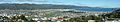
Lower Hutt from Normandale, in the western hills. On the right is the entrance to Wellington Harbour, with Matiu / Somes Island beneath. The Hutt River snakes from the right background to the left mid-ground, entering the harbour between the suburbs of Seaview and Petone. The Wainuiomata Hill Road climbs the hills in the centre background (the track in the middle of the left half of the background is a firebreak, not a road). At the foot of the Wainuiomata Hill Road is the Gracefield industrial area.
-
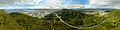
A panorama taken from 400 feet above the Wanuiomata hills. Wellington Harbour can be seen on the far left, with Petone and the Hutt Valley towards the middle of the image. The Wainuiomata Hill road can be seen curling around the bottom right of the image as it snakes into the suburb of Wainuiomata on the right hand side.
-
Lower Hutt from the top of the Wainuiomata hills. This viewpoint can be seen in the top panorama by following the ridgeline left from the top of the Wainuiomata Hill Road to the first major firebreak
-

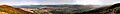
Wellington Harbour and southern Lower Hutt from the top of the Wainuiomata Hill Road (south of the above photo), looking west. Matiu / Somes Island is in the harbour on the left (South), and beyond that the row of lights along State Highway 2, marking the line of the geologic fault, both of which continue up the far side of the valley to the right. The industrial area in the central foreground is Gracefield. In the distance, behind Matiu / Somes Island, are Wellington port and CBD.
See also
 In Spanish: Lower Hutt para niños
