
Merritt Island, Florida facts for kids
Quick facts for kids
Merritt Island, Florida
|
|
|---|---|
 |
|

Location in Brevard County and the state of Florida
|
|
| Country | |
| State | |
| County | Brevard |
| Area | |
| • Total | 46.16 sq mi (119.54 km2) |
| • Land | 16.97 sq mi (43.96 km2) |
| • Water | 29.18 sq mi (75.59 km2) |
| Elevation | 3 ft (1 m) |
| Population
(2020)
|
|
| • Total | 34,518 |
| • Density | 2,033.94/sq mi (785.30/km2) |
| Time zone | UTC-5 (Eastern (EST)) |
| • Summer (DST) | UTC-4 (EDT) |
| ZIP Codes |
32952–32954
|
| Area code(s) | 321 |
| FIPS code | 12-44275 |
| GNIS feature ID | 0294625 |
Merritt Island is a peninsula in Brevard County, Florida. It's often called an island because it's surrounded by water on three sides. Located on Florida's eastern coast, it faces the Atlantic Ocean.
Merritt Island is also the name of a town and a census-designated place (CDP) within this area. In 2020, about 34,518 people lived there.
NASA's John F. Kennedy Space Center is on the northern part of Merritt Island. North of the space center is the Merritt Island National Wildlife Refuge. The central part of Merritt Island, once called Merritt City, has most of the people, schools, and shops. The southern area is mostly homes, with some small businesses.
Contents
Discovering Merritt Island's Past
How Merritt Island Got Its Name
Merritt Island was named by the King of Spain. He gave the entire island as a land grant to a nobleman named Merritt.
Ancient Times: Dinosaurs and Early People
Long ago, huge animals like mammoths, mastodons, and giant armadillos lived here. Scientists have found their bones during digs. These animals lived until about 11,000 years ago. They likely died out because of big changes in the climate.
Later, the Clovis culture arrived. These early people were skilled hunters. They used special stone tools, including some of the first spears and arrowheads. Around 800-900 BC, Native Americans built permanent structures here. They created large mounds along the lagoon.
European Arrival and Modern Growth
In 1605, Spanish explorer Álvaro Mexía visited the local Native American tribes. He met the Ais people who lived along the Indian River. A map he drew shows Merritt Island clearly. Sadly, most of these native people died from a disease after a British ship crashed nearby.
In the 1760s, the Elliott Plantation grew sugar cane on the island. You can still find parts of it in the Wildlife Refuge. In 1788, French botanist André Michaux explored Merritt Island. He studied the local plants, discovering a new type of paw-paw tree.
In 1837, Fort Ann was built on the east coast of Merritt Island. It protected the area from the local Seminoles. In the mid-1800s, Merritt Island became known for growing citrus fruits like oranges and pineapples. The famous Indian River oranges and grapefruit come from this sandy soil.
After the Civil War, freed slaves built small towns like Haulover and Shiloh. The island's population grew a lot in the 1950s and 1960s. This was because of the Space Race and the growth of NASA nearby. Many small towns disappeared as the Space Age began. Today, their names live on in streets and historic churches.
Exploring Merritt Island's Geography
.jpg)
Merritt Island stretches about 46 miles (74 km) long. It goes from the Volusia County line down to Dragon Point near Melbourne. It connects to mainland Florida where SR 3 meets US 1.
To the west, the Indian River separates it from the mainland. To the east, the Mosquito Lagoon and Banana River separate it from the barrier island where Cape Canaveral and Cocoa Beach are located. The east side of Merritt Island is also divided by Sykes Creek.
In the north, the Haulover Canal separates the island from the mainland. Merritt Island is connected to the mainland by several causeways. It's also linked to Cape Canaveral by the Crawlerway and to Cocoa Beach by other causeways.
The area of Merritt Island is about 47.2 square miles (122.2 km²). Most of this is water, making up about 62.88% of its total area.
Wildlife of Merritt Island
The northern part of Merritt Island is home to the Merritt Island National Wildlife Refuge. This area protects wildlife and acts as a buffer for rocket launches at Kennedy Space Center.
About 356 different kinds of birds live here, making it one of the most diverse bird habitats in the country. Many migratory birds visit, joining local animals. You can find alligators, manatees, dolphins, sea turtles, bald eagles, ospreys, and bobcats. The rare Florida panther also lives here. Bald eagle nests are watched closely on power poles within Kennedy Space Center.
There are also about 12,000 feral pigs in North Merritt Island. Trappers help keep their numbers steady.
Communities on Merritt Island
Merritt Island has many small communities, all part of the larger unincorporated area. Some of these include:
- Allenhurst
- Angel City
- Audubon
- Banyan
- Courtenay
- Fairyland
- Georgiana
- Heath
- Indianola
- Lotus
- Merritt City
- Orsino
- Shiloh
- Tropic
- Wilson
People and Population
| Historical population | |||
|---|---|---|---|
| Census | Pop. | %± | |
| 1990 | 32,886 | — | |
| 2000 | 36,090 | 9.7% | |
| 2010 | 34,743 | −3.7% | |
| 2020 | 34,518 | −0.6% | |
| U.S. Decennial Census | |||
In 2020, there were 34,518 people living in Merritt Island. There were 13,790 households and 8,600 families.
Population Changes Over Time
The table below shows the different groups of people living in Merritt Island in 2010 and 2020.
| Race | Pop 2010 | Pop 2020 | % 2010 | % 2020 |
|---|---|---|---|---|
| White (NH) | 29,241 | 27,770 | 84.16% | 80.45% |
| Black or African American (NH) | 1625 | 846 | 4.68% | 2.45% |
| Native American or Alaska Native (NH) | 137 | 115 | 0.39% | 0.33% |
| Asian (NH) | 772 | 1,029 | 2.22% | 2.98% |
| Pacific Islander or Native Hawaiian (NH) | 37 | 72 | 0.11% | 0.21% |
| Some other race (NH) | 63 | 126 | 0.18% | 0.37% |
| Two or more races/Multiracial (NH) | 739 | 1,772 | 2.13% | 5.13% |
| Hispanic or Latino (any race) | 2,129 | 2,788 | 6.13% | 8.08% |
| Total | 34,743 | 34,518 | 100.00% | 100.00% |
Economy and Jobs
Merritt Island has light industrial areas, especially those supporting NASA and rocket launches at Cape Canaveral Space Force Station. For example, Air Liquide has a plant here. Arnott Air Suspension Products, which makes car parts, also has its main office in Merritt Island.
The county also has a special agency working to redevelop and improve areas of Merritt Island.
Education for Students

Merritt Island has several schools for students of all ages.
Public Schools
These schools are run by Brevard Public Schools:
- MILA Elementary
- Tropical Elementary
- Audubon Elementary
- Robert Louis Stevenson School of the Arts
- Lewis Carroll Elementary
- Thomas Jefferson Middle School
- Edgewood Junior/Senior High School
- Merritt Island High School
Private Schools
- Merritt Island Christian
- Calvary Chapel Christian School
- Brevard Private Academy
Merritt Island Public Library
The Merritt Island Public Library is part of the Brevard County Library System. It's also a special library district, meaning it has its own unique setup. This was created by the Florida Legislature in 1965.
Getting Around: Roads and Airport
Roads and Bridges
Merritt Island is connected to the mainland and nearby barrier islands by causeways and bridges. These include:
 SR 520 (Merritt Island Causeway)
 State Road 404 (Pineda Causeway)
 State Road 405
 State Road 406
 SR 528
The Mathers Bridge connects the very southern part of the island to the barrier island. ![]() SR 3 is a four-lane highway that helps workers get to the Kennedy Space Center from other parts of the island.
SR 3 is a four-lane highway that helps workers get to the Kennedy Space Center from other parts of the island.
Merritt Island Airport
The Merritt Island Airport is a public airport for general aviation. It's located on South Merritt Island and is managed by the Titusville-Cocoa (TICO) Airport Authority.
Famous Places and Landmarks
Merritt Island has many interesting places to visit:
- J. R. Field Homestead
- Hacienda del Sol (a historic farm estate)
- Haulover Canal
- Dr. George E. Hill House
- Kennedy Space Center
- Merritt Island Airport
- Merritt Island (Canaveral) Barge Canal
- Merritt Island Dragon
- Merritt Island National Wildlife Refuge
- Kiwanis Island Park
- Merritt Island Rotary Park Nature Trail and Center
- Pine Island Conservation Area, a 950-acre preserve. It includes Sams House, built in 1875, which is Brevard's oldest standing building.
- Old St. Luke's Episcopal Church and Cemetery
- Ulumay Wildlife Sanctuary
- Futch Cove on Banana Creek (where the Apollo/Saturn Visitors Center used to be)
- Merritt Square Mall
Notable People from Merritt Island
- Tim DeMorat, football player
- Arias Deukmedjian, racing driver
- Taylor Jordan, baseball player
- Travis Kittleson, racing driver
- Roy Padrick, actor and journalist
Images for kids
-
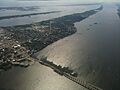
Merritt Island skyline.
-
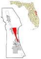
Map showing Merritt Island's location.
See also
 In Spanish: Merritt Island para niños
