Monmouth Beach, New Jersey facts for kids
Quick facts for kids
Monmouth Beach, New Jersey
|
||
|---|---|---|
|
Borough
|
||

Monmouth Beach Bathing Pavilion
|
||
|
||
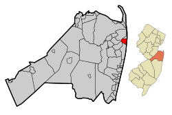
Map of Monmouth Beach in Monmouth County. Inset: Location of Monmouth County highlighted in the State of New Jersey.
|
||
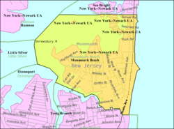
Census Bureau map of Monmouth Beach, New Jersey
|
||
| Country | ||
| State | ||
| County | Monmouth | |
| Incorporated | March 9, 1906 | |
| Government | ||
| • Type | Walsh Act | |
| • Body | Board of Commissioners | |
| Area | ||
| • Total | 2.07 sq mi (5.37 km2) | |
| • Land | 1.04 sq mi (2.70 km2) | |
| • Water | 1.03 sq mi (2.67 km2) 49.81% | |
| Area rank | 406th of 565 in state 30th of 53 in county |
|
| Elevation | 20 ft (6 m) | |
| Population
(2020)
|
||
| • Total | 3,174 | |
| • Estimate
(2023)
|
3,204 | |
| • Rank | 441st of 565 in state 39th of 53 in county |
|
| • Density | 3,046.1/sq mi (1,176.1/km2) | |
| • Density rank | 216th of 565 in state 24th of 53 in county |
|
| Time zone | UTC−05:00 (Eastern (EST)) | |
| • Summer (DST) | UTC−04:00 (Eastern (EDT)) | |
| ZIP Code |
07750
|
|
| Area code(s) | 732 | |
| FIPS code | 3402547130 | |
| GNIS feature ID | 0885305 | |
| Website | ||
Monmouth Beach is a small town, called a borough, located in Monmouth County, New Jersey. It's part of the beautiful Jersey Shore area in Central Jersey. In 2020, about 3,174 people lived here.
This area was first settled way back in 1668. It started to grow into a community when the Long Branch and Sea Shore Railroad arrived. Many of the first people to live here were professional fishermen, some with Norwegian backgrounds. Monmouth Beach officially became a borough on March 9, 1906.
In 2023, the average price for a home in Monmouth Beach was around $974,409. This was a slight increase from the year before.
Contents
Exploring Monmouth Beach's Geography
Monmouth Beach covers about 2.07 square miles (5.37 square kilometers). Almost half of this area is land, and the other half is water.
A Coastal Community
This borough is a small beach town right on the Jersey Shore. It's known for its charming Victorian style houses. You can also see many newer, large homes throughout the area. In the past, Hurricane Sandy caused damage to many homes here.
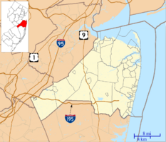
Monmouth Beach is about one square mile in size. The Atlantic Ocean is to its east, and the Shrewsbury River is to its northwest.
Nearby Towns and Features
You'll find a community called Galilee partly within Monmouth Beach. There's also the Sea Bright–Monmouth Beach Seawall that runs along the ocean.
Monmouth Beach shares borders with other towns in Monmouth County. These include Little Silver, Long Branch, Oceanport, Rumson, and Sea Bright.
Fun Things to Do in Monmouth Beach
Monmouth Beach has two popular beach clubs. One is the Monmouth Beach Bathing Pavilion, often called "Little Monmouth." The other is the Monmouth Beach Bath and Tennis Club, known as "Big Monmouth." Both clubs offer pools and beach access. They have lockers, activities, and even swim teams. Many local families and people from nearby areas enjoy these clubs.
You can go fishing in Monmouth Beach, and there are also waves good for surfing. The Shrewsbury River, which is next to the borough, is great for sailing, kayaking, and fishing. Most of Monmouth Beach is made up of homes.
For more fun, you can visit the many restaurants, lounges, and bars in West End. Pier Village in Long Branch is another popular spot. Other places to explore include Red Bank and the many beaches along the shore, like Asbury Park.
Monmouth Beach Population Facts
| Historical population | |||
|---|---|---|---|
| Census | Pop. | %± | |
| 1910 | 485 | — | |
| 1920 | 410 | −15.5% | |
| 1930 | 457 | 11.5% | |
| 1940 | 584 | 27.8% | |
| 1950 | 806 | 38.0% | |
| 1960 | 1,363 | 69.1% | |
| 1970 | 2,042 | 49.8% | |
| 1980 | 3,318 | 62.5% | |
| 1990 | 3,303 | −0.5% | |
| 2000 | 3,595 | 8.8% | |
| 2010 | 3,279 | −8.8% | |
| 2020 | 3,174 | −3.2% | |
| 2023 (est.) | 3,204 | −2.3% | |
| Population sources: 1910–1920 1910 1910–1930 1940–2000 2000 2010 2020 |
|||
Population in 2010
In 2010, the 2010 United States census counted 3,279 people living in Monmouth Beach. There were 1,494 households and 855 families. The population density was about 3,049.5 people per square mile.
Most residents, about 97.50%, were White. A small number were Black or African American (0.34%), Native American (0.09%), or Asian (0.73%). About 1.89% of the population was Hispanic or Latino.
About 21.7% of households had children under 18. The average household had 2.19 people, and the average family had 2.96 people. The median age in Monmouth Beach was 48.7 years old.
How Monmouth Beach is Governed
Local Government Structure
Monmouth Beach has been governed by a three-member commission since 1929. This is a special type of local government called the Walsh Act system. The three commissioners are elected by all voters in the town. They serve four-year terms at the same time. These elections happen every four years in May.
As of 2023, the Borough Commission members are:
- Mayor David F. Stickle (who handles Public Affairs and Public Safety)
- Lawrence M. Bolsch (who handles Revenue and Finance)
- Timothy Somers (who handles Public Works, Parks, and Public Property)
Their terms are set to end in May 2025.
State and County Representation
Monmouth Beach is part of the 6th Congressional District for national elections. For state laws, it's in New Jersey's 13th state legislative district.
New Jersey's Sixth Congressional District is represented by Frank Pallone (D, Long Branch). New Jersey is represented in the United States Senate by Cory Booker (D, Newark, term ends 2021) and Bob Menendez (D, Paramus, 2019). For the 2016–2017 session (Senate, General Assembly), the 13th Legislative District of the New Jersey Legislature is represented in the State Senate by Joseph M. Kyrillos (R, Middletown Township) and in the General Assembly by Amy Handlin (R, Middletown Township) and Declan O'Scanlon (R, Little Silver). Monmouth County is governed by a Board of County Commissioners composed of five members who are elected at-large to serve three-year terms of office on a staggered basis, with either one or two seats up for election each year as part of the November general election. At an annual reorganization meeting held in the beginning of January, the board selects one of its members to serve as director and another as deputy director. As of 2024[update], Monmouth County's Commissioners are:
Director Thomas A. Arnone (R, Neptune City, 2025), Susan M. Kiley (R, Hazlet Township, 2024), Erik Anderson (R, Shrewsbury, 2026), Nick DiRocco (R, Wall Township, 2025), and Deputy Director Ross F. Licitra (R, Marlboro Township, 2026).
Constitutional officers elected on a countywide basis are: Clerk Christine Giordano Hanlon (R, 2025; Ocean Township), Sheriff Shaun Golden (R, 2025; Howell Township) and Surrogate Rosemarie D. Peters (R, 2026; Middletown Township).
Political Views
| Year | Republican | Democratic | Third party | |||
|---|---|---|---|---|---|---|
| No. | % | No. | % | No. | % | |
| 2024 | 1,259 | 56.46% | 937 | 42.02% | 34 | 1.52% |
| 2020 | 1,357 | 56.59% | 1,024 | 42.70% | 17 | 0.71% |
| 2016 | 1,163 | 59.52% | 754 | 38.59% | 37 | 1.89% |
| 2012 | 1,132 | 62.54% | 662 | 36.57% | 16 | 0.88% |
| 2008 | 1,196 | 58.14% | 837 | 40.69% | 24 | 1.17% |
| 2004 | 1,270 | 60.30% | 817 | 38.79% | 19 | 0.90% |
| 2000 | 1,070 | 52.97% | 873 | 43.22% | 77 | 3.81% |
| 1996 | 868 | 49.54% | 734 | 41.89% | 150 | 8.56% |
| 1992 | 953 | 49.71% | 677 | 35.32% | 287 | 14.97% |
In March 2011, there were 2,550 registered voters in Monmouth Beach. About 23.7% were registered as Democrats. About 29.1% were registered as Republicans. The largest group, 47.1%, were registered as Unaffiliated, meaning they didn't pick a party.
In the 2012 presidential election, most voters in Monmouth Beach supported the Republican candidate, Mitt Romney. In the 2008 election, the Republican candidate, John McCain, also received the most votes. The same was true in 2004, with Republican George W. Bush getting the most votes.
For the 2013 governor's election in New Jersey, Republican Chris Christie won by a large margin in Monmouth Beach. He also won in the 2009 election.
Education in Monmouth Beach
Students in Monmouth Beach attend public schools.
Elementary and Middle School
Children from pre-kindergarten through eighth grade go to Monmouth Beach School. This school is part of the Monmouth Beach School District. In the 2018–19 school year, there were 236 students and 26.5 teachers. This means there were about 8.9 students for every teacher. A kindergarten teacher from this school, Karen Ginty, was named the 2006–2007 New Jersey State Teacher of the Year.
High School Education
Students in ninth through twelfth grade attend Shore Regional High School. This high school is a regional school, meaning it also serves students from nearby towns like Oceanport, Sea Bright, and West Long Branch. The high school is located in West Long Branch.
In the 2018–19 school year, Shore Regional High School had 649 students and 57.2 teachers. This means there were about 11.3 students for every teacher. Monmouth Beach has one representative on the high school district's nine-member board of education.
Vocational Schools
Students from Monmouth Beach can also apply to attend special schools offered by the Monmouth County Vocational School District. These schools provide training in different job skills.
Getting Around Monmouth Beach
Roads and Highways
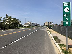
As of 2010, Monmouth Beach had about 15.76 miles of roads. Most of these roads (14.12 miles) are maintained by the town itself. The remaining 1.64 miles are maintained by the New Jersey Department of Transportation.
Route 36, also known as Ocean Avenue, is the main highway in Monmouth Beach. It connects the borough to Long Branch to the south and Sea Bright to the north.
Public Transportation Options
If you want to travel to New York City, the SeaStreak ferry is a good option. It takes about 10–15 minutes to drive to the ferry terminals in Atlantic Highlands or Highlands. From there, you can take a ferry directly to Wall Street and the East Side of Manhattan.
Monmouth Beach Climate and Weather
Monmouth Beach has a humid subtropical climate. This means it has warm, humid summers and mild winters. The average temperature is above 32 degrees Fahrenheit all year. Summers are usually warm, with temperatures often above 71.6 degrees Fahrenheit. Even though there's a cooling afternoon sea breeze, it can get very hot and humid sometimes. The highest temperature recorded since 1981 was 100.2 degrees Fahrenheit on August 9, 2001.
The wettest month is usually July, which is when most thunderstorms happen. The most rain in one day since 1981 was 5.62 inches on August 27, 2011.
In winter, the average coldest temperature is around 4.4 degrees Fahrenheit. The coldest temperature ever recorded since 1981 was -4.5 degrees Fahrenheit on January 22, 1984. It can feel even colder with the wind chill. On average, Monmouth Beach gets about 18 to 24 inches of snow each winter. February is usually the snowiest month, often due to big winter storms called nor'easters.
| Climate data for Monmouth Beach, 1981–2010 normals, extremes 1981–2019 | |||||||||||||
|---|---|---|---|---|---|---|---|---|---|---|---|---|---|
| Month | Jan | Feb | Mar | Apr | May | Jun | Jul | Aug | Sep | Oct | Nov | Dec | Year |
| Record high °F (°C) | 70.8 (21.6) |
78.8 (26.0) |
82.3 (27.9) |
88.2 (31.2) |
94.9 (34.9) |
96.4 (35.8) |
99.9 (37.7) |
100.2 (37.9) |
97.1 (36.2) |
93.1 (33.9) |
78.9 (26.1) |
74.7 (23.7) |
100.2 (37.9) |
| Mean daily maximum °F (°C) | 39.7 (4.3) |
42.3 (5.7) |
48.9 (9.4) |
58.6 (14.8) |
68.2 (20.1) |
77.6 (25.3) |
82.8 (28.2) |
81.7 (27.6) |
75.5 (24.2) |
64.8 (18.2) |
54.9 (12.7) |
44.8 (7.1) |
61.7 (16.5) |
| Daily mean °F (°C) | 32.5 (0.3) |
34.8 (1.6) |
41.0 (5.0) |
50.4 (10.2) |
60.1 (15.6) |
69.6 (20.9) |
75.2 (24.0) |
74.2 (23.4) |
67.8 (19.9) |
56.7 (13.7) |
47.6 (8.7) |
37.9 (3.3) |
54.1 (12.3) |
| Mean daily minimum °F (°C) | 25.4 (−3.7) |
27.3 (−2.6) |
33.0 (0.6) |
42.3 (5.7) |
52.0 (11.1) |
61.7 (16.5) |
67.5 (19.7) |
66.8 (19.3) |
60.0 (15.6) |
48.5 (9.2) |
40.2 (4.6) |
31.0 (−0.6) |
46.4 (8.0) |
| Record low °F (°C) | −4.5 (−20.3) |
1.7 (−16.8) |
6.5 (−14.2) |
18.4 (−7.6) |
36.7 (2.6) |
45.3 (7.4) |
48.7 (9.3) |
46.4 (8.0) |
39.5 (4.2) |
27.1 (−2.7) |
16.2 (−8.8) |
−0.5 (−18.1) |
−4.5 (−20.3) |
| Average precipitation inches (mm) | 3.56 (90) |
2.96 (75) |
3.84 (98) |
4.17 (106) |
3.90 (99) |
3.66 (93) |
4.67 (119) |
4.63 (118) |
3.65 (93) |
3.95 (100) |
3.73 (95) |
3.96 (101) |
46.68 (1,186) |
| Average relative humidity (%) | 65.4 | 62.0 | 61.1 | 62.6 | 66.2 | 70.5 | 69.9 | 71.0 | 71.6 | 69.4 | 67.6 | 65.6 | 66.9 |
| Average dew point °F (°C) | 22.2 (−5.4) |
23.1 (−4.9) |
28.6 (−1.9) |
38.1 (3.4) |
48.8 (9.3) |
59.6 (15.3) |
64.7 (18.2) |
64.2 (17.9) |
58.3 (14.6) |
46.8 (8.2) |
37.4 (3.0) |
27.4 (−2.6) |
43.4 (6.3) |
| Source: PRISM | |||||||||||||
| Climate data for Sandy Hook Buoy, 10 N Monmouth Beach, NJ (Ocean Water Temperature) | |||||||||||||
|---|---|---|---|---|---|---|---|---|---|---|---|---|---|
| Month | Jan | Feb | Mar | Apr | May | Jun | Jul | Aug | Sep | Oct | Nov | Dec | Year |
| Daily mean °F (°C) | 37 (3) |
36 (2) |
40 (4) |
46 (8) |
55 (13) |
62 (17) |
69 (21) |
72 (22) |
68 (20) |
59 (15) |
51 (11) |
43 (6) |
53 (12) |
| Source: NOAA | |||||||||||||
Local Ecology and Nature
Monmouth Beach's natural plant life would mostly be Oak trees, forming an Eastern Hardwood Forest. The area is in plant hardiness zone 7a. This means the average coldest temperature in winter is around 4.4 degrees Fahrenheit. New leaves usually appear around March 24, and fall colors are at their best in early November.
Famous People from Monmouth Beach
Many interesting people have lived in or are connected to Monmouth Beach:
- William Warren Barbour (1888–1943), who represented New Jersey in the United States Senate.
- Warren A. Croll Jr. (1920-2008), a famous horse trainer.
- William Fargo (1818–1881), who helped start the well-known company Wells Fargo.
- John Farrell (born 1962), a former baseball player and manager for the Boston Red Sox.
- Jim Garrett (1930–2018), an NFL football player and coach.
- Kim Guadagno (born 1959), a former Monmouth Beach commissioner and the first Lieutenant Governor of New Jersey.
- Jay Gould (1836–1892), a very powerful railroad businessman.
- Garret Hobart (1844–1899), who served as the Vice President of the United States.
- Philip B. Hofmann (1909–1986), a businessman who led Johnson & Johnson.
- Frederick K. Humphreys (1816–1900), a doctor who founded a medicine company.
- Guglielmo Marconi (1874–1937), a famous inventor who helped create wireless radio.
- Malcolm McKesson (1909–1999), an artist known for his unique drawings.
- Priscilla Ransohoff (1912–1992), an expert in military education and a supporter of women in science.
- Brian Wenning (born 1981), a professional skateboarder.
See also
 In Spanish: Monmouth Beach para niños


