
National Register of Historic Places listings in Marion County, Florida facts for kids

Welcome to Marion County, Florida! This area is home to many amazing places that are super important to history. These special spots are listed on something called the National Register of Historic Places. Think of it like a Hall of Fame for buildings, areas, and sites that tell us about the past.
There are 33 of these cool places in Marion County. One of them is even more special and is called a National Historic Landmark. These landmarks are super important to the history of the entire United States!
| Alachua - Baker - Bay - Bradford - Brevard - Broward - Calhoun - Charlotte - Citrus - Clay - Collier - Columbia - DeSoto - Dixie - Duval - Escambia - Flagler - Franklin - Gadsden - Gilchrist - Glades - Gulf - Hamilton - Hardee - Hendry - Hernando - Highlands - Hillsborough - Holmes - Indian River - Jackson - Jefferson - Lafayette - Lake - Lee - Leon - Levy - Liberty - Madison - Manatee - Marion - Martin - Miami-Dade (Miami) - Monroe - Nassau - Okaloosa - Okeechobee - Orange - Osceola - Palm Beach - Pasco - Pinellas - Polk - Putnam - St. Johns - St. Lucie - Santa Rosa - Sarasota - Seminole - Sumter - Suwannee - Taylor - Union - Volusia - Wakulla - Walton - Washington |
Contents
Exploring Marion County's Historic Places
Marion County has many interesting places that have been saved because they are important to history. These places can be old houses, churches, schools, or even whole neighborhoods! They help us remember what life was like a long time ago.
Homes with History
Many old houses in Marion County are on the National Register. These homes often show us how people lived and built things in the past. For example:
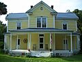
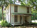
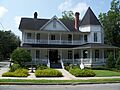
- The Armstrong House in Citra is a beautiful old home.
- The Alfred Ayer House and Thomas R. Ayer House near Ocklawaha are also historic. They are part of a group of early homes in rural Marion County.
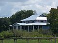
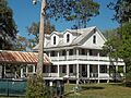
- The Gen. Robert Bullock House is another historic home in Ocklawaha.
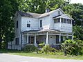
- The Robert W. Ferguson House near Emathla is a historic farmhouse.
- The James Riley Josselyn House in Eastlake Weir gives us a peek into the past.
- The Morgan-Townsend House in Salt Springs and the James W. Townsend House in Orange Springs are also on the list.
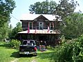
- The T. W. Randall House in Silver Springs is another example of an important old home.
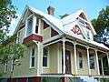
- The E. C. Smith House in Ocala is also a protected historic home.
Historic Buildings and Sites
Beyond homes, other buildings and sites have been recognized for their importance:
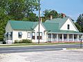
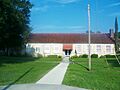
- The Belleview School in Belleview is an old school building that taught many students over the years.
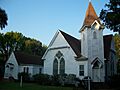
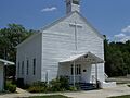
- The Citra Methodist Episcopal Church-South is a historic church in Citra.
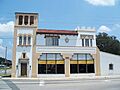
- The Coca-Cola Bottling Plant in Ocala is an interesting building that shows how drinks were made long ago.
- East Hall in Ocala is another historic building.
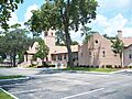
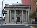
- The Golden-Collum Memorial Federal Building & U.S. Courthouse in Ocala is an important government building.
- Fort King Site near Ocala is a very special place. It's a National Historic Landmark because it played a big role in early Florida history, especially during the Seminole Wars.
- The Lake Weir Yacht Club in Eastlake Weir is a historic club by the water.
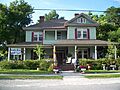
- The Marion Hotel in Ocala is an old hotel that welcomed many travelers.
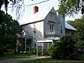
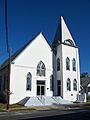
- The Mount Zion A.M.E. Church in Ocala is a significant church with a rich history.
- The Ocala Union Station is an old train station in Ocala, where people used to arrive and depart.
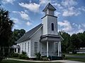
- The Orange Springs Methodist Episcopal Church and Cemetery is a historic church and burial ground.
- The Ritz Apartment in Ocala is an old apartment building.
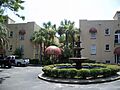
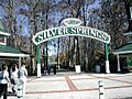
- Silver Springs is a famous natural spring in Florida. It's known for its clear waters and glass-bottom boat tours, and it's also a historic site!
Historic Districts: Whole Neighborhoods with Stories
Sometimes, it's not just one building, but a whole area that's historic. These are called "historic districts."
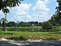
- The Dunnellon Boomtown Historic District in Dunnellon tells the story of a town that grew quickly.
- The Kerr City Historic District near Fort McCoy is another area that keeps its old-town feel.
- The Lake Lillian Neighborhood Historic District in Belleview is a historic neighborhood.
- The McIntosh Historic District in McIntosh is a charming area with many old buildings.
- The Ocala Historic Commercial District is the old business heart of Ocala.
- The Ocala Historic District covers a larger part of Ocala with many historic buildings.
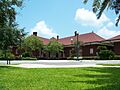
- The Old Fessenden Academy Historic District in Ocala was once an important school.
- The Tuscawilla Park Historic District in Ocala is a historic park area.
- The West Ocala Historic District is another historic neighborhood in Ocala.
These places help us learn about the past and make sure these important stories are not forgotten!
Images for kids
-
Armstrong House
-
Alfred Ayer House
-
Thomas R. Ayer House
-
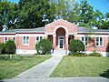
Belleview School
-
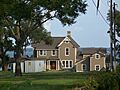
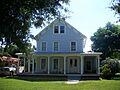
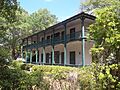
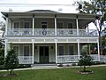
Gen. Robert Bullock House
-
Citra Methodist Episcopal Church-South
-
Coca-Cola Bottling Plant
-
Dunnellon Boomtown Historic District
-
East Hall
-

Golden-Collum Memorial Federal Building & U.S. Courthouse
-
Robert W. Ferguson House
-
Fort King Site
-
James Riley Josselyn House
-
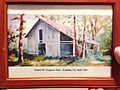
Kerr City Historic District
-
Lake Lillian Neighborhood Historic District
-
Lake Weir Yacht Club
-
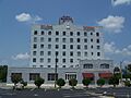
Marion Hotel
-
McIntosh Historic District
-
Morgan-Townsend House
-
Mount Zion A.M.E. Church
-
Ocala Historic Commercial District
-
Ocala Historic District
-
Ocala Union Station
-
Old Fessenden Academy Historic District
-
Orange Springs Methodist Episcopal Church and Cemetery
-
T. W. Randall House
-
The Ritz Apartment
-
Silver Springs
-
E. C. Smith House
-
James W. Townsend House
-
Tuscawilla Park Historic District
-
West Ocala Historic District


See also
