
National Register of Historic Places listings in St. Lucie County, Florida facts for kids

Have you ever wondered about the oldest and most special buildings or places in your area? In St. Lucie County, Florida, there are many such spots! These places are so important that they are listed on the National Register of Historic Places. This is like a special list kept by the United States government. It helps protect places that tell us about history.
There are 16 different places in St. Lucie County that are on this important list. One of them is even a National Historic Landmark, which means it's super important to the whole country! Let's explore some of these cool historic sites.
| Alachua - Baker - Bay - Bradford - Brevard - Broward - Calhoun - Charlotte - Citrus - Clay - Collier - Columbia - DeSoto - Dixie - Duval - Escambia - Flagler - Franklin - Gadsden - Gilchrist - Glades - Gulf - Hamilton - Hardee - Hendry - Hernando - Highlands - Hillsborough - Holmes - Indian River - Jackson - Jefferson - Lafayette - Lake - Lee - Leon - Levy - Liberty - Madison - Manatee - Marion - Martin - Miami-Dade (Miami) - Monroe - Nassau - Okaloosa - Okeechobee - Orange - Osceola - Palm Beach - Pasco - Pinellas - Polk - Putnam - St. Johns - St. Lucie - Santa Rosa - Sarasota - Seminole - Sumter - Suwannee - Taylor - Union - Volusia - Wakulla - Walton - Washington |
What is the National Register of Historic Places?
The National Register of Historic Places is the official list of the nation's historic places. It is part of a program to coordinate and support public and private efforts. This program helps to identify, evaluate, and protect America's historic and archaeological resources. When a place is on this list, it means it is special because of its history, architecture, or what happened there.
Historic Buildings and Homes
Many places on the list are old buildings or homes. They show us how people lived and worked a long time ago.
The Arcade Building
The Arcade Building in Fort Pierce is a cool old building. It was added to the list in 2001. Imagine walking through its halls and thinking about all the people who have been there before!
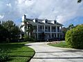
Casa Caprona
Casa Caprona is another historic home in Fort Pierce. It was recognized in 1984. This house has a unique design that tells us about the style of buildings from its time.
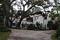
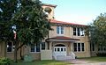
Cresthaven (Boston House)
Also known as the Boston House, Cresthaven is a beautiful old home on South Indian River Drive. It joined the list in 1985. These homes often have stories about the families who lived in them.
Jules Frere House
The Jules Frere House, located on Sunrise Boulevard, became a historic place in 1995. It's another example of the interesting architecture you can find in Fort Pierce.
Captain Hammond House
In White City, you can find the Captain Hammond House. This house was added to the list in 1990. It's a great example of the older homes in the area.
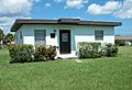
Immokolee
Immokolee is a historic property in Fort Pierce that was listed in 1994. Its name and design often hint at the history of the land and its first owners.
Important Public Buildings
Some buildings on the list were once important public places where people gathered or got services.
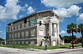
Old Fort Pierce Post Office
The Old Fort Pierce Post Office, built on Orange Avenue, was added to the list in 2002. Imagine sending letters from this very building many years ago!
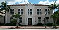
Old Fort Pierce City Hall
The Old Fort Pierce City Hall, located on Avenue A, became a historic site in 2001. This is where important decisions for the city were made for many years.
Old St. Anastasia Catholic School
The Old St. Anastasia Catholic School, also on Orange Avenue, was recognized in 2000. Many children learned and grew up in this building.
St. Lucie High School
St. Lucie High School, on Delaware Avenue, joined the list in 1984. This school has seen many students pass through its doors over the decades.
Special Historic Sites
Zora Neale Hurston House
One of the most important places is the Zora Neale Hurston House in Fort Pierce. It became a National Historic Landmark in 1991! Zora Neale Hurston was a very famous American writer. She lived in this house, and it's important because of her amazing contributions to literature and culture.
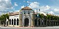
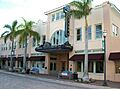
Sunrise Theatre
The Sunrise Theatre, on South 2nd Street, was added to the list in 2001. This old theater has hosted many shows and performances. It's a place where people have come together for entertainment for a long time.
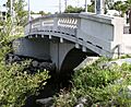
Moores Creek Bridge
The Moores Creek Bridge, located on North 2nd Street, became a historic site in 2001. Bridges are important for connecting places, and this one has a special history.
Fort Pierce Site (Old Fort Pierce Park)
The Fort Pierce Site, also known as Old Fort Pierce Park, was listed in 1974. This area is important because it's where the original Fort Pierce was located. It tells us about the early history of the area.
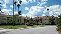
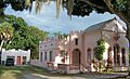
St. Lucie Village Historic District
Instead of just one building, the St. Lucie Village Historic District includes a whole area. It was recognized in 1989. This means that many buildings in this part of St. Lucie Village are historically important together. They show how a community grew over time.
The Urca de Lima Shipwreck
One of the most unique listings is the URCA DE LIMA shipwreck! This old Spanish ship sank off the coast of Fort Pierce in 1715. It was added to the list in 2001. It's an amazing underwater historic site that divers can visit. It tells us about the exciting history of shipwrecks and treasure fleets in Florida.
Images for kids
-
The Arcade Building in Fort Pierce.
-
Casa Caprona, a historic home.
-
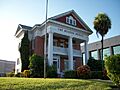
Cresthaven, also known as the Boston House.
-
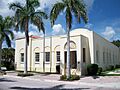
The Old Fort Pierce Post Office.
-
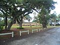
Old Fort Pierce Park.
-
The Jules Frere House.
-
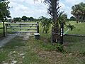
The Captain Hammond House in White City.
-
The Zora Neale Hurston House.
-
Immokolee.
-
The Moores Creek Bridge.
-
The Old Fort Pierce City Hall.
-
The Old St. Anastasia Catholic School.
-
St. Lucie High School.
-
A house in the St. Lucie Village Historic District.
-
The historic Sunrise Theatre.


