
National Register of Historic Places listings in Manatee County, Florida facts for kids

This page is about the special places in Manatee County, Florida, that are listed on the National Register of Historic Places. Think of the National Register as a very important list of buildings, areas, and sites that are super old or have a big story to tell about American history.
When a place is on this list, it means it's recognized for its historical or architectural importance. It's like giving a medal to a building or a park because it's a piece of our past! Manatee County has 33 of these amazing places. You can even see some of them on a map if their location details are shared.
| Alachua - Baker - Bay - Bradford - Brevard - Broward - Calhoun - Charlotte - Citrus - Clay - Collier - Columbia - DeSoto - Dixie - Duval - Escambia - Flagler - Franklin - Gadsden - Gilchrist - Glades - Gulf - Hamilton - Hardee - Hendry - Hernando - Highlands - Hillsborough - Holmes - Indian River - Jackson - Jefferson - Lafayette - Lake - Lee - Leon - Levy - Liberty - Madison - Manatee - Marion - Martin - Miami-Dade (Miami) - Monroe - Nassau - Okaloosa - Okeechobee - Orange - Osceola - Palm Beach - Pasco - Pinellas - Polk - Putnam - St. Johns - St. Lucie - Santa Rosa - Sarasota - Seminole - Sumter - Suwannee - Taylor - Union - Volusia - Wakulla - Walton - Washington |
Contents
- What is the National Register of Historic Places?
- Manatee County's Historic Treasures
- Braden Castle Park Historic District
- Bradenton Carnegie Library
- Cortez Historic District
- De Soto National Memorial
- Gamble Plantation Historic State Park
- Madira Bickel Mound State Archeological Site
- Manatee County Courthouses
- Palmetto Historic District
- Portavant Mound Site
- Regina Shipwreck Site
- Whitfield Estates Historic Districts
- Images for kids
What is the National Register of Historic Places?
The National Register of Historic Places is the United States government's official list of buildings, districts, objects, sites, and structures that are important in American history, architecture, archaeology, engineering, and culture. It's managed by the National Park Service. Getting on this list helps protect these places and makes people more aware of their value. It's a way to make sure these important parts of our history are saved for future generations, like you!
Manatee County's Historic Treasures
Manatee County is full of history, and many of its special spots are recognized on the National Register. These places tell stories about how people lived, worked, and built communities long ago. From old houses to important natural sites, each one helps us understand Florida's past. Let's explore some of these cool places!
Braden Castle Park Historic District
Imagine a place where an old castle once stood! The Braden Castle Park Historic District in Bradenton is named after a sugar plantation owner, Dr. Joseph Braden. While the "castle" was more like a strong, fortified home, its ruins are still there. This area is special because it shows us how early settlers lived and built their homes near the Manatee River and Braden River. It's a glimpse into Florida's pioneer days.
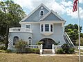
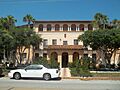
Bradenton Carnegie Library
Libraries are often important historical buildings, and the Bradenton Carnegie Library is a great example. Located in Bradenton, this building was once a public library, built with money from the famous businessman and philanthropist Andrew Carnegie. Carnegie helped build thousands of libraries across the world. This library is a reminder of how important reading and education were, and still are, to communities.
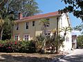
Cortez Historic District
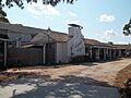
The Cortez Historic District in Cortez is a unique place that shows off Florida's fishing heritage. This district is a historic fishing village. It has many old buildings that tell the story of the people who made their living from the sea. Walking through Cortez is like stepping back in time to see how coastal communities thrived. It's a living museum of Florida's fishing past.
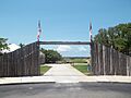
De Soto National Memorial
Near Bradenton, you'll find the De Soto National Memorial. This site remembers the landing of Hernando de Soto in 1539. He was a Spanish explorer who led one of the first big European expeditions into what is now the southeastern United States. The memorial helps us learn about the early interactions between European explorers and Native American communities. It's a place to reflect on a very important moment in American history.
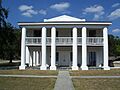
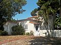
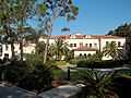
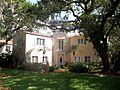
Gamble Plantation Historic State Park
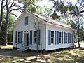
The Gamble Plantation Historic State Park in Ellenton is home to the Robert Gamble House. This beautiful house was built around 1850. It's made of a special material called tabby concrete, which is a mix of oyster shells, lime, sand, and water. The house was part of a large sugar cane plantation. It's also famous because a Confederate official, Judah P. Benjamin, hid there after the Civil War. Today, you can visit this state park and learn about life on a 19th-century Florida plantation.
Madira Bickel Mound State Archeological Site
The Madira Bickel Mound State Archeological Site in Terra Ceia is a very old and important place. It's a Native American ceremonial mound. This mound shows evidence of people living there as far back as 2,000 years ago! It's a fascinating site that helps archaeologists and historians understand the ancient cultures that lived in Florida long before European settlers arrived. It's a true treasure of Florida's earliest history.
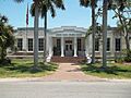
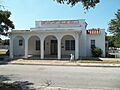
Manatee County Courthouses
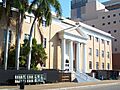
Manatee County has two courthouses on the National Register: the Manatee County Courthouse and the Old Manatee County Courthouse. Both are in Bradenton. The older courthouse, built in 1913, is a beautiful example of early 20th-century architecture. These buildings are important because they represent the center of government and law in the county for many years. They show how the community grew and developed over time.
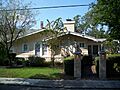
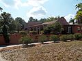
Palmetto Historic District
The Palmetto Historic District in Palmetto is another area that has kept its historic charm. This district includes many old buildings that show the architecture and lifestyle of the past. It's a great place to see how a Florida town developed along the Manatee River. You can imagine what life was like for the people who lived and worked there many years ago.
Portavant Mound Site
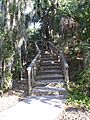
The Portavant Mound site, located in Palmetto, is an ancient Native American temple mound. It's about 1,200 years old and is the largest temple mound in southwest Florida! This site also includes a midden complex, which is basically a very old trash heap made of shells and other discarded items. These middens are super helpful for archaeologists because they tell us a lot about what ancient people ate and how they lived. Today, it's part of a county park, allowing visitors to learn about Florida's earliest inhabitants.
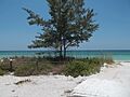
Regina Shipwreck Site
Off the coast of Bradenton Beach lies the Regina Shipwreck Site. This is the underwater remains of a ship called the SS Regina, which sank in 1940. Shipwrecks are like time capsules at the bottom of the ocean. They offer clues about maritime history, trade, and even the dangers of sea travel. This site is a fascinating piece of history hidden beneath the waves.
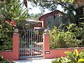
Whitfield Estates Historic Districts
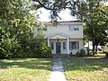
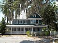
Several places in the Whitfield Estates area of Sarasota are listed on the National Register. These include the Austin House, John M. Beasley House, Reid-Woods House, Paul M. Souder House, Stevens-Gilchrist House, Villa Serena Apartments, and the Whitfield Estates-Lantana Avenue and Broughton Street Historic Districts. These areas are special because they show the unique architectural styles and community planning from a specific time in Florida's development. They give us a peek into the elegant homes and neighborhoods of the past.
Images for kids
-
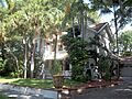
Austin House
-
John M. Beasley House
-
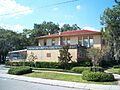
Bradenton Carnegie Library
-
Cortez Historic District
-
De Soto National Memorial
-
Robert Gamble House at Gamble Plantation Historic State Park
-
Johnson Helm House
-
Rufus P. Jordan House
-
Kreissle Forge
-
Madira Bickel Mounds
-
Manatee County Courthouse
-
Old Manatee County Courthouse
-
Midway Subdivision Historic District
-
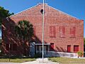
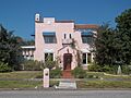
Palmetto Armory
-
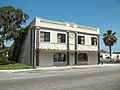
Palmetto Historic District
-
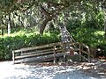
Portavant Mound Site
-
Egbert Reasoner House
-
Regina Shipwreck Site
-
Reid-Woods House
-
Richardson House
-
Seagate
-
Paul M. Souder House
-
Stevens-Gilchrist House
-
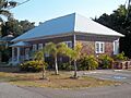
Terra Ceia Village Improvement Association Hall
-
Villa Serena Apartments
-
Whitfield Estates-Lantana Avenue Historic District
-
Whitfield Estates-Broughton Street Historic District
-
Woman's Club of Palmetto


