Olmsted County, Minnesota facts for kids
Quick facts for kids
Olmsted County
|
|
|---|---|

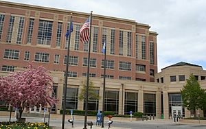
Olmsted County Government Center (pre-expansion)
|
|

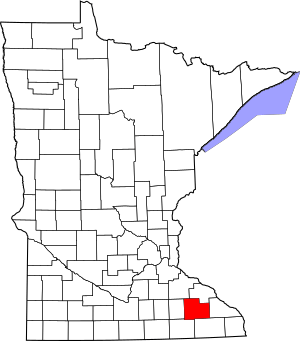
Location within the U.S. state of Minnesota
|
|
 Minnesota's location within the U.S. |
|
| Country | |
| State | |
| Founded | February 20, 1855 |
| Named for | David Olmsted |
| Seat | Rochester |
| Largest city | Rochester |
| Area | |
| • Total | 655 sq mi (1,700 km2) |
| • Land | 653 sq mi (1,690 km2) |
| • Water | 1.5 sq mi (4 km2) 0.2%% |
| Population
(2020)
|
|
| • Total | 162,847 |
| • Estimate
(2023)
|
164,784 |
| • Density | 249/sq mi (96/km2) |
| Time zone | UTC−6 (Central) |
| • Summer (DST) | UTC−5 (CDT) |
| Congressional district | 1st |
Olmsted County is a special area in the U.S. state of Minnesota. It's called a county. In 2020, about 162,847 people lived here. The main city and county center is Rochester.
Olmsted County is also part of a bigger area called the Rochester Metropolitan Statistical Area. This means it's connected to Rochester and nearby towns.
Contents
History of Olmsted County
The land where Olmsted County is now was once part of the Wisconsin Territory. This territory was set up in 1836. Later, in 1849, the Minnesota Territory was created.
In October 1849, new counties were formed. One of them was Wabasha County. Parts of Wabasha County were later used to create Fillmore and Rice counties in 1853.
Then, on February 20, 1855, parts of Rice, Wabasha, and Fillmore counties were combined. This created Olmsted County as we know it today. The city of Rochester was also planned out that same year and became the county seat.
The county was named after David Olmsted (1822-1861). He was an important person in the first Minnesota territorial government. He was also the fourth mayor of St. Paul. The borders of Olmsted County have not changed since 1855.
Geography and Nature
Olmsted County has a unique mix of city and country areas. There isn't much in between. Rochester is Minnesota's third-largest city. It has about 118,000 people and sits in the Zumbro River valley.
Outside of Rochester, most of the county is farmland. There are small farming towns. Stewartville is the second-largest city, with about 6,000 people.
Rivers and Land
Three rivers flow through Olmsted County. They all eventually reach the Mississippi River.
- The Zumbro River flows north through the middle of the county.
- The Whitewater River flows northeast.
- The Root River flows southeast.
The land here has gentle rolling hills. It also has small valleys and some higher points called buttes. Most of the land is used for farming or other buildings. The highest point in the county is a hill about 7.5 miles (12.1 km) west of Stewartville. It is about 1,380 ft (420 m) above sea level.
Olmsted County covers about 655 square miles (1,700 km2). Most of this is land (653 square miles (1,690 km2)). Only a small part (1.5 square miles (3.9 km2)) is water. It is one of only four counties in Minnesota that do not have any natural lakes.
Lakes and Reservoirs
Even though Olmsted County has no natural lakes, it does have six reservoirs. These are lakes created by dams.
- Chester Lake: in Eyota Township
- Lake Florence: in High Forest Township
- Lake George: in Rochester Township
- Mayowood Lake: in Rochester Township
- Silver Lake: in Haverhill Township and Cascade Township
- Lake Zumbro (part): in Oronoco Township
Parks and Protected Areas
Olmsted County has many parks and natural areas where you can enjoy the outdoors.
- Chester Woods Park
- High Forest Wildlife Management Area
- Keller Wildlife Management Area
- Marian Marshall Wildlife Management Area
- Nelson Fen Wildlife Management Area
- Oronoco Scientific and Natural Area
- Oxbow Park & Zollman Zoo
- Root River Park
- Schumann State Wildlife Management Area
- Suess State Wildlife Management Area
- Whitewater Wildlife Management Area (part)
Getting Around
There are several ways to travel in and out of Olmsted County.
Public Transportation
- Jefferson Lines (bus service)
- Rochester Public Transit (local bus service)
Major Roads
Many important highways run through Olmsted County, connecting it to other places.
 Interstate 90
 U.S. Highway 14
 U.S. Highway 52
 U.S. Highway 63
 Minnesota State Highway 30
 Minnesota State Highway 42
 Minnesota State Highway 74
 Minnesota State Highway 247
 Olmsted County Highway 22
Airports
- Mid-Continent Airport
- Rochester International Airport (RST)
Neighboring Counties
Olmsted County shares its borders with several other counties.
- Wabasha County - to the north
- Winona County - to the east
- Fillmore County - to the south
- Mower County - to the southwest
- Dodge County - to the west
- Goodhue County - to the northwest
Population of Olmsted County
The number of people living in Olmsted County has grown a lot over the years.
| Historical population | |||
|---|---|---|---|
| Census | Pop. | %± | |
| 1860 | 9,524 | — | |
| 1870 | 19,793 | 107.8% | |
| 1880 | 21,543 | 8.8% | |
| 1890 | 19,806 | −8.1% | |
| 1900 | 23,119 | 16.7% | |
| 1910 | 22,497 | −2.7% | |
| 1920 | 28,014 | 24.5% | |
| 1930 | 35,426 | 26.5% | |
| 1940 | 42,658 | 20.4% | |
| 1950 | 48,228 | 13.1% | |
| 1960 | 65,532 | 35.9% | |
| 1970 | 84,104 | 28.3% | |
| 1980 | 92,006 | 9.4% | |
| 1990 | 106,470 | 15.7% | |
| 2000 | 124,277 | 16.7% | |
| 2010 | 144,248 | 16.1% | |
| 2020 | 162,847 | 12.9% | |
| 2023 (est.) | 164,784 | 14.2% | |
| U.S. Decennial Census 1790-1960 1900-1990 1990-2000 2010-2020 |
|||
2020 Census Information
According to the census in 2020, Olmsted County had 162,847 residents. This means there were about 249.2 inhabitants per square mile (96.2/km2) people per square mile. There were also 69,270 homes.
The people living in the county come from many different backgrounds.
- About 77.8% were White.
- About 6.8% were Black or African American.
- About 6.3% were Asian.
- About 0.4% were Native American.
- About 0.1% were Pacific Islander.
- About 2.5% were from other races.
- About 6.1% were from two or more races.
Also, about 5.6% of the population identified as Hispanic or Latino. This shows that Olmsted County is a diverse place!
Communities in Olmsted County
Olmsted County is made up of several cities and smaller communities.
Cities
- Byron
- Chatfield (partly in another county)
- Dover
- Eyota
- Oronoco
- Pine Island (partly in another county)
- Rochester (the main city and county seat)
- Stewartville
Unincorporated Communities
These are smaller towns or areas that are not officially organized as cities.
Townships
Townships are smaller local government areas, often covering rural land.
- Cascade Township
- Dover Township
- Elmira Township
- Eyota Township
- Farmington Township
- Haverhill Township
- High Forest Township
- Kalmar Township
- Marion Township
- New Haven Township
- Orion Township
- Oronoco Township
- Pleasant Grove Township
- Quincy Township
- Rochester Township
- Rock Dell Township
- Salem Township
- Viola Township
See also
 In Spanish: Condado de Olmsted para niños
 | Jessica Watkins |
 | Robert Henry Lawrence Jr. |
 | Mae Jemison |
 | Sian Proctor |
 | Guion Bluford |


