
Pike County, Missouri facts for kids
Quick facts for kids
Pike County
|
|
|---|---|

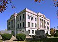
The Pike County Courthouse in Bowling Green
|
|

Location within the U.S. state of Missouri
|
|
 Missouri's location within the U.S. |
|
| Country | |
| State | |
| Founded | December 14, 1818 |
| Named for | Zebulon M. Pike |
| Seat | Bowling Green |
| Largest city | Bowling Green |
| Area | |
| • Total | 685 sq mi (1,770 km2) |
| • Land | 670 sq mi (1,700 km2) |
| • Water | 14 sq mi (40 km2) 2.1% |
| Population
(2020)
|
|
| • Total | 17,587 |
| • Density | 25.674/sq mi (9.913/km2) |
| Time zone | UTC−6 (Central) |
| • Summer (DST) | UTC−5 (CDT) |
| Congressional district | 6th |
Pike County is a county in the state of Missouri, USA. It is located on the eastern side of the state. The famous Mississippi River forms its eastern border.
In 2020, about 17,587 people lived in Pike County. The main town, or county seat, is Bowling Green. The county was named after a city in Kentucky. Many early settlers came from that area.
Pike County was officially created on December 14, 1818. It was named after the explorer Zebulon Pike. You might know the folk song "Sweet Betsy from Pike". Many people think this song is about Pike County, Missouri.
Some people say that Momo (The Missouri Monster) lives in Pike County. There were reports of seeing this creature in the 1970s. These sightings happened in different places around the county.
Contents
Discovering Pike County's Past
The first European settler in Pike County was William Spencer. He arrived in 1799. Spencer came to a place called Spencer Lick. This area had a natural salt spring. He wanted to make salt to sell in St. Louis. St. Louis was a new and growing town back then.
Spencer had to leave his business. This was because Native American groups became a threat to his safety. He moved his salt-making business to Ralls County.
How Pike County Grew and Changed
When Pike County was first created in 1818, it was much bigger. It included its current area. It also covered all the counties to its north. Plus, it included counties to the west of those. This made it about 6 or 7 times larger than it is today. It covered a huge part of what is now northeast Missouri.
Over time, Pike County became smaller. New counties were formed from its land. These included Ralls, Marion, Lewis, Clark, Scotland, Knox, Shelby, and Monroe counties.
Early Settlers and Later Challenges
The first settlers in Pike County came from the southern United States. Some of these settlers supported the Confederate side later during the American Civil War. After the Civil War, some people in the county created laws that separated people based on race. These were called Jim Crow laws. This happened even though important Union Army operations were based in Pike County during the war.
Exploring Pike County's Geography
Pike County covers a total area of 685 square miles. About 670 square miles of this is land. The remaining 14 square miles, or 2.1%, is water.
Neighboring Counties Around Pike County
Pike County shares its borders with several other counties:
- Ralls County (to the northwest)
- Pike County, Illinois (to the northeast)
- Calhoun County, Illinois (to the east)
- Lincoln County (to the south)
- Montgomery County (to the southwest)
- Audrain County (to the west)
Getting Around Pike County: Transit and Roads
You can travel through Pike County using different ways.
Public Transportation
- Burlington Trailways
- OATS Transit
Railroads
- BNSF Railway
- Canadian Pacific Kansas City
Main Roads and Highways
 US 54
US 54
US 54 Bus.
US 54 Bus.
 US 61
US 61
US 61 Bus.
US 61 Spur Route 79
 Route 154
 Route 161
 Great River Road
Old Roads of Pike County
Some roads that used to be important include:
- Red Ball Route
- Mississippi River Scenic Route
 Route 9
 Route 22
 Route 26
 Route 29
Protected Natural Areas
Pike County's Population Over Time
| Historical population | |||
|---|---|---|---|
| Census | Pop. | %± | |
| 1820 | 3,747 | — | |
| 1830 | 6,129 | 63.6% | |
| 1840 | 10,646 | 73.7% | |
| 1850 | 13,609 | 27.8% | |
| 1860 | 18,417 | 35.3% | |
| 1870 | 23,076 | 25.3% | |
| 1880 | 26,715 | 15.8% | |
| 1890 | 26,321 | −1.5% | |
| 1900 | 25,744 | −2.2% | |
| 1910 | 22,556 | −12.4% | |
| 1920 | 20,345 | −9.8% | |
| 1930 | 18,001 | −11.5% | |
| 1940 | 18,327 | 1.8% | |
| 1950 | 16,844 | −8.1% | |
| 1960 | 16,706 | −0.8% | |
| 1970 | 16,928 | 1.3% | |
| 1980 | 17,568 | 3.8% | |
| 1990 | 15,969 | −9.1% | |
| 2000 | 18,351 | 14.9% | |
| 2010 | 18,516 | 0.9% | |
| 2020 | 17,587 | −5.0% | |
| U.S. Decennial Census 1790-1960 1900-1990 1990-2000 2010 |
|||
In 2010, there were 18,516 people living in Pike County. There were 6,451 households. About 4,476 of these were families. The population density was about 27 people per square mile.
Most people in the county were White (88.44%). About 9.17% were Black or African American. Other groups made up smaller percentages. About 1.61% of the population was Hispanic or Latino.
The average household had 2.50 people. The average family had 3.01 people.
In terms of age, 23.40% of the population was under 18. About 15.00% were 65 years or older. The average age in the county was 38 years old.
The median income for a household was $32,373. For a family, it was $39,059. About 15.50% of the population lived below the poverty line.
Pike County's Population in 2020
| Race | Num. | Perc. |
|---|---|---|
| White (NH) | 15,383 | 87.47% |
| Black or African American (NH) | 942 | 5.36% |
| Native American (NH) | 40 | 0.23% |
| Asian (NH) | 23 | 0.13% |
| Pacific Islander (NH) | 7 | 0.04% |
| Other/Mixed (NH) | 758 | 4.31% |
| Hispanic or Latino | 434 | 2.47% |
Learning in Pike County: Schools and Libraries
Pike County has several schools and public libraries.
Public Schools in Pike County
- Boncl R-X School District in Louisiana
- Boncl Elementary School (Grades PK-8)
- Bowling Green R-I School District in Bowling Green
- Bowling Green Elementary School (Grades PK-5)
- Frankford Elementary School (Grades K-5)
- Bowling Green Middle School (Grades 6-8)
- Bowling Green High School (Grades 9-12)
- Louisiana R-II School District in Louisiana
- Louisiana Elementary School (Grades PK-5)
- Louisiana Middle School (Grades 6-8)
- Louisiana High School (Grades 9-12)
- Pike County R-III School District in Clarksville
- Clopton Elementary School (Grades PK-6)
- Clopton High School (Grades 7-12)
Private Schools in Pike County
- Pike County Christian School in Curryville (Grades K-11) – This is a Baptist school.
- St. Clement School in Bowling Green (Grades K-9) – This is a Roman Catholic school.
Public Libraries in Pike County
- Bowling Green Free Public Library
- Clarksville Public Library
- Louisiana Public Library
Communities of Pike County
Pike County is home to several cities, villages, and other communities.
Cities in Pike County
- Bowling Green (This is the county seat)
- Clarksville
- Curryville
- Frankford
- Louisiana
Villages in Pike County
Census-Designated Places
These are areas that are like towns but are not officially incorporated as cities or villages.
Other Unincorporated Places
Images for kids
-
The Pike County Courthouse in Bowling Green
See also
In Spanish: Condado de Pike (Misuri) para niños
