
Precipitation facts for kids


In meteorology, precipitation is any form of water that falls from clouds to Earth. It happens when water vapor in the air cools down and turns into liquid water or ice. This water then falls because of gravity. Common types of precipitation include drizzle, rain, sleet, snow, ice pellets, graupel, and hail.
Precipitation forms when the air becomes full of water vapor, reaching 100% relative humidity. This causes the water to condense and fall. Things like fog and mist are not precipitation because their water vapor doesn't condense enough to fall. Air can become saturated in two main ways: by cooling down or by having more water vapor added to it. Tiny water droplets or ice crystals in a cloud bump into each other and stick together, growing larger until they are heavy enough to fall. Short, heavy rain in small areas is called a shower.
When moist air rises over a layer of very cold air near the ground, it can form clouds and rain. This often causes freezing rain. A stationary front is usually nearby, pushing the air upwards. If there's enough moisture, the rising air forms clouds like nimbostratus or cumulonimbus. Eventually, cloud droplets grow into raindrops and fall. If they hit freezing surfaces, they turn to ice.
Near warm bodies of water, like lakes, lake-effect snow can happen. This is when cold air blows over the warmer lake, picking up moisture, which then falls as heavy snow downwind. Thundersnow can also occur in these snow bands. In mountains, heavy precipitation falls on the windward (upwind) side where air is forced to rise. On the leeward (downwind) side, the air dries out as it sinks, creating rain shadows and even deserts. Most precipitation in warm, tropical areas comes from rising warm air. The movement of the monsoon trough brings rainy seasons to places like savannahs.
Precipitation is a huge part of the water cycle. It brings fresh water to our planet. About 505,000 cubic kilometers (121,000 cubic miles) of water fall as precipitation each year. Most of this (398,000 cubic kilometers) falls over the oceans. This means the average yearly precipitation worldwide is about 990 millimeters (39 inches). Over land, it's about 715 millimeters (28 inches). Climate systems, like the Köppen climate classification, use average rainfall to define different climates. Global warming is changing weather patterns, causing more rain in some places and less in others, leading to more extreme weather.
Precipitation can even happen on other planets! Titan, Saturn's largest moon, has methane rain that falls slowly like drizzle. Scientists have seen puddles of it on Titan's surface.
Contents
- Types of Precipitation
- How Air Becomes Saturated
- Forms of Precipitation
- Causes of Precipitation
- Measuring Precipitation with Technology
- Return Period of Storms
- Uneven Precipitation Patterns
- Precipitation and Climate Zones
- Effect on Agriculture
- Changes Due to Global Warming
- Changes Due to Urban Heat Islands
- Forecasting Precipitation
- See also
- Images for kids
Types of Precipitation

Precipitation is a key part of the water cycle. It brings most of the fresh water to Earth. About 505,000 cubic kilometers (121,000 cubic miles) of water falls as precipitation each year. Most of it (398,000 cubic kilometers) falls over the oceans. This means the average yearly precipitation worldwide is about 990 millimeters (39 inches).
Precipitation can be caused by different things. These include strong upward air movements (convective), weaker upward movements (stratiform), or air rising over mountains (orographic lift). Convective processes cause strong, quick vertical air movement and heavy rain. Stratiform processes involve gentler upward movement and lighter rain.
Precipitation is divided into three main types:
- Liquid water (like rain)
- Liquid water that freezes when it hits a surface (like freezing rain)
- Ice (like snow or hail)
Sometimes, different types of precipitation can fall at the same time.
Measuring Precipitation
We measure precipitation to understand weather and climate.
Measuring Liquid Precipitation

Rain and drizzle are usually measured with a rain gauge. The amount is given in millimeters (mm) of height or depth. For example, 10 mm of rain means that if the ground were perfectly flat and the rain didn't soak in or run off, there would be a 10 mm deep layer of water. In some places, inches are used instead.
Measuring Solid Precipitation
A snow gauge measures solid precipitation like snow. Snowfall is usually measured in centimeters by letting it fall into a container and then measuring its height. The snow can also be melted to find its "water equivalent" in millimeters. This tells you how much water is in the snow. The amount of water in snow can vary a lot. Other forms of solid precipitation, like snow pellets or hail, can also be melted and measured as water equivalent.
How Air Becomes Saturated
For precipitation to form, the air needs to become saturated with water vapor. This means it can't hold any more moisture.
Cooling Air to its Dew Point


The dew point is the temperature at which air must cool to become saturated. When air cools to its dew point, water vapor usually starts to condense. It forms tiny water droplets on condensation nuclei, which are tiny particles like dust, ice, or salt in the air. These tiny droplets then form clouds.
There are four main ways air cools to its dew point:
- Adiabatic cooling: This happens when air rises and expands. As air rises, the pressure on it decreases, causing it to expand and cool. Air can rise due to convection (warm air rising), large-scale air movements, or when it hits a mountain (orographic lift).
- Conductive cooling: This occurs when air touches a colder surface. For example, when air blows from a warm ocean surface to colder land.
- Radiational cooling: This happens when air or the ground underneath it releases heat into space.
- Evaporative cooling: This occurs when moisture is added to the air through evaporation. This process cools the air, sometimes to its wet-bulb temperature, until it becomes saturated.
Adding Moisture to the Air
Water vapor can be added to the air in several ways:
- Wind blowing together into areas where air is rising.
- Precipitation or virga (rain that evaporates before reaching the ground) falling from above.
- Daytime heating causing water to evaporate from oceans, lakes, or wet land.
- Transpiration from plants (plants release water vapor).
- Cool or dry air moving over warmer water.
- Air being lifted over mountains.
Forms of Precipitation

Raindrops

Raindrops form through a process called coalescence. This is when small water droplets in a cloud combine to form larger ones. Or, water droplets can freeze onto an ice crystal, a process called the Bergeron process. Very small droplets don't fall because they are too light. Precipitation only happens when these tiny droplets combine into bigger drops. As raindrops get bigger, they fall faster. This causes them to collide with even more droplets, growing larger until they are heavy enough to fall as rain.
Raindrops can range from about 5.1 millimeters (0.2 inches) to 20 millimeters (0.8 inches) in diameter. Larger drops tend to break apart. Small cloud droplets are spherical. As a raindrop grows, it becomes more flattened on the bottom, like a hamburger bun, not a teardrop shape as often shown in cartoons. Heavy rainstorms usually last for a shorter time, while light rain can last longer.
Ice Pellets

Ice pellets, also called sleet, are small, clear balls of ice. They are usually smaller than hailstones. Ice pellets often bounce when they hit the ground. They generally don't freeze into a solid mass unless they mix with freezing rain.
Ice pellets form when snowflakes fall through a layer of air that is above freezing. This causes the snowflakes to melt partially or completely. Then, they fall into another layer of air that is below freezing, closer to the ground. In this cold layer, they refreeze into ice pellets. If the cold layer near the ground is too thin, the melted snow won't have enough time to refreeze, and you'll get freezing rain instead.
Hail

Hail forms in strong storm clouds. It starts when supercooled water droplets (water that's colder than freezing but still liquid) freeze onto tiny particles like dust. Strong updrafts (currents of air moving upwards) in the storm blow these tiny hailstones higher into the cloud. They fall back down, get caught in the updraft again, and are lifted up. Each time they go up, they collect more supercooled water, which freezes onto them, making them grow larger.
Hailstones are usually 5 millimeters (0.2 inches) or larger in diameter. Some hailstones can grow very large, up to 15 centimeters (6 inches) across, and weigh more than 500 grams (1.1 pounds). When hailstones get very big, the heat released by the freezing water can melt their outer layer. This allows them to collect other small hailstones, growing even larger with each trip up and down in the storm. Once a hailstone is too heavy for the updraft to hold, it falls from the cloud.
Snowflakes

Snow crystals form when tiny supercooled cloud droplets (about 10 micrometers wide) freeze. Once a droplet freezes, it grows in the very moist air. Because there are more water droplets than ice crystals, the ice crystals grow larger by taking water vapor from the droplets. This process is called the Wegener–Bergeron–Findeisen process. As the ice crystals grow, the water droplets shrink and evaporate. These large ice crystals are good at forming precipitation because they fall through the air. They can also collide and stick together in clumps, forming snowflakes. These clumps are usually what falls to the ground as snow.
Even though ice is clear, snowflakes often look white. This is because light scatters off the many facets and imperfections of the ice crystals. The shape of a snowflake depends on the temperature and humidity where it forms. Rarely, at about -2°C (28°F), snowflakes can form with three sides, like triangles. Most snow particles are irregular, but perfect snowflakes are often seen in pictures because they look nice. No two snowflakes are exactly alike because they grow at different rates and in different patterns as they fall through changing temperatures and humidity in the atmosphere.
Diamond Dust
Diamond dust, also called ice needles or ice crystals, forms in very cold temperatures, around -40°C (-40°F). It happens when slightly moister air from higher up mixes with colder air near the ground. These are simple, hexagonal ice crystals.
Causes of Precipitation
Frontal Activity
Precipitation often happens along weather fronts. These are boundaries between different air masses.
- Cold fronts: When cold air pushes into warm air, it forces the warm air to rise quickly, leading to clouds and precipitation.
- Warm fronts: When warm air moves over colder air, it slowly rises over the cold air, forming wide areas of clouds and steady precipitation.
- Occluded fronts: These form when a cold front catches up to a warm front. They can bring various weather, including thunderstorms, but often lead to drier air after they pass.
Precipitation can also occur on other planets. For example, when it gets cold on Mars, it likely has precipitation in the form of ice needles, not rain or snow.
Convection

Convective rain, or showery precipitation, comes from convective clouds like cumulonimbus (thunderstorm clouds) or cumulus congestus. It falls as showers with quickly changing intensity. Convective precipitation usually covers a small area for a short time because these clouds are not very wide. Most rain in tropical areas is convective. Graupel and hail are signs of strong convection. In middle latitudes, convective rain happens on and off, often with cold fronts or squall lines. These systems can bring very heavy rain, thunderstorms, and strong winds.
Orographic Effects

Orographic precipitation happens on the windward (upwind) side of mountains. It's caused by moist air being forced to rise as it moves across a mountain range. As the air rises, it cools down and condenses, forming clouds and precipitation. In mountainous areas with steady winds, the windward side is usually much wetter than the leeward (downwind) side. The mountains block the moisture, leaving drier air on the leeward side, which creates a rain shadow.
For example, in Hawaii, Mount Waiʻaleʻale on Kauai is one of the wettest places on Earth. It gets a lot of rain because of the trade winds. The Sierra Nevada mountains in North America create the Great Basin and Mojave Desert rain shadows. In Asia, the Himalaya mountains block monsoons, causing very high rainfall on their southern side and much less on the northern side.
Snowfall

Extratropical cyclones can bring cold, dangerous weather with heavy rain and snow. The band of precipitation with their warm front is often wide and steady, falling from nimbostratus clouds. When moist air tries to move into a very cold arctic air mass, snow can fall on the colder side of the rain band.
Southwest of these cyclones, cold air blowing across relatively warm lakes can create narrow lake-effect snow bands. These bands bring strong, localized snowfall. Large lakes store heat, creating big temperature differences between the water surface and the air above it. This difference causes warmth and moisture to rise, forming tall clouds that produce snow showers.
In mountainous areas, heavy snowfall builds up when air is forced to climb the mountains. As the air rises, it cools and releases precipitation as snow. Predicting exactly where heavy snowfall will occur in rugged terrain is still a big challenge for forecasters.
Precipitation in the Tropics

The wet, or rainy, season is the time of year when most of a region's average annual rainfall occurs. This happens in parts of the tropics and subtropics. Savanna climates and areas with monsoons have wet summers and dry winters. Tropical rainforests don't really have wet or dry seasons because their rain is spread out evenly all year.
During the wet season, air quality often gets better, freshwater quality improves, and plants grow a lot. However, soil nutrients can decrease, and erosion increases. Animals have ways to adapt to the wetter conditions. The dry season before the wet season can lead to food shortages until the first harvest, which happens late in the wet season.
Tropical cyclones, like hurricanes or typhoons, bring very heavy rainfall. They are huge air masses with low pressure at the center and winds blowing inwards. While cyclones can cause a lot of damage, they are very important for bringing much-needed rain to dry areas. Some places can get a whole year's worth of rain from just one tropical cyclone.
Global Precipitation Patterns
Globally, the highest amounts of precipitation outside of mountains fall in the tropics. This is closely linked to the Intertropical Convergence Zone, where air rises. Places near the equator in Colombia are among the wettest on Earth. North and south of this zone are areas where air sinks, forming subtropical ridges. These areas have low precipitation and are where most of the Earth's deserts are found.
An exception is Hawaii, where trade winds cause air to rise over the islands, making it very wet. In North America, the Westerlies winds bring moisture to the Rocky Mountains, making them very wet and snowy at high elevations. In Asia, during the wet season, moist air flowing into the Himalayas causes some of the highest rainfall amounts on Earth in northeast India.
Measuring Precipitation with Technology
Hydrometeor Definition
A hydrometeor is any particle of liquid or solid water in the atmosphere. This includes clouds, haze, fog, and mist. All types of precipitation, including virga (rain that evaporates before hitting the ground), are hydrometeors. Particles blown from the Earth's surface by wind, like blowing snow or sea spray, are also considered hydrometeors.
Satellite Estimates
While ground-based rain gauges are the standard for measuring precipitation, they can't be used everywhere, like over vast oceans or remote land areas. So, scientists use satellites to measure precipitation globally.
Satellite sensors measure precipitation by detecting different parts of the electromagnetic spectrum that are related to how much and how intensely it's raining or snowing. Most sensors are passive, meaning they just record what they "see," like a camera.
Two main types of satellite sensors are used:
- Infrared (IR) sensors: These record heat signals from cloud tops. Colder cloud tops are usually higher and indicate more active storms. Algorithms use this information to estimate precipitation.
- Microwave sensors: These detect signals from liquid water (rain and drizzle) in the lower parts of clouds and from solid ice particles (snow, graupel) higher up. Satellites like the Tropical Rainfall Measuring Mission (TRMM) and the Global Precipitation Measurement (GPM) mission use microwave sensors.
Satellites in geosynchronous Earth orbit provide IR estimates very frequently (every 15 minutes or more). These work best for strong storms, especially in the tropics. Microwave sensors are more accurate for short times and small areas, but they are on satellites in low Earth orbit, so they don't pass over the same spot as often (usually every three hours or more).
Scientists combine data from many different satellites to get the best possible estimates of precipitation across the globe. They also use some ground-based rain gauge data to make the satellite estimates even more accurate, especially for long-term climate records.
Return Period of Storms
The return period or frequency describes how likely an event, like a storm, is to happen. It tells you how often a storm of a certain strength is expected to occur.
- A 1 in 10 year storm means a rainfall event that is rare and is only likely to happen once every 10 years. So, there's a 10% chance it will happen in any given year. The rain and flooding will be worse than what's expected in a typical year.
- A 1 in 100 year storm is extremely rare. It's only likely to happen once in a century, meaning there's a 1% chance it will occur in any given year. This storm will bring extreme rainfall and much worse flooding than a 1 in 10 year event. It's important to remember that it's still possible, though unlikely, to have two "1 in 100 year storms" in the same year.
Uneven Precipitation Patterns
In many places, a large part of the yearly precipitation falls on just a few days. For example, about 50% of the annual rain often falls during the 12 wettest days of the year.
Precipitation and Climate Zones
The Köppen climate classification system uses average monthly temperature and precipitation to define different climate types. There are five main types:
- A: Tropical
- B: Dry
- C: Mild mid-latitude
- D: Cold mid-latitude
- E: Polar
These main types are further divided into more specific climates:
- Rain forests have very high rainfall, usually between 1,750 and 2,000 millimeters (69 to 79 inches) per year.
- A tropical savanna is a grassland with rainfall between 750 and 1,270 millimeters (30 to 50 inches) a year. They are common in Africa, India, and parts of South America and Australia.
- Humid subtropical climates are found on the east sides of continents, roughly between 20° and 40° latitude. They have winter rain (and sometimes snow) from large storms, and summer rain from thunderstorms and occasional tropical cyclones.
- An oceanic (or maritime) climate is typically found along the west coasts of continents in the middle latitudes, next to cool oceans. They have plenty of rain all year.
- The Mediterranean climate has hot, dry summers and cool, wet winters. It's found around the Mediterranean Sea, parts of western North America, Australia, South Africa, and Chile.
- A steppe is a dry grassland.
- Subarctic climates are very cold with permanently frozen ground (permafrost) and little precipitation.
Effect on Agriculture

Rain, as a form of precipitation, greatly affects farming. All plants need water to grow, so rain is very important for crops. While regular rain is good for healthy plants, too much or too little can be harmful.
- Droughts (too little rain) can kill crops and increase soil erosion.
- Overly wet weather (too much rain) can cause harmful fungi to grow on plants.
Different plants need different amounts of rain. For example, some cacti need very little water, while tropical plants might need hundreds of inches of rain each year.
In areas with wet and dry seasons, soil nutrients can decrease, and erosion increases during the wet season. Animals in these regions have special ways to adapt and survive. The dry season often leads to food shortages before the first harvest, which happens late in the wet season. In developing countries, people sometimes show changes in weight due to these food shortages before the crops are ready.
Changes Due to Global Warming

Rising temperatures generally cause more evaporation, which can lead to more precipitation. From 1900 to 2005, precipitation has generally increased over land north of 30°N. However, it has decreased in tropical areas since the 1970s. Overall, there hasn't been a clear global trend in precipitation over the last century, but changes vary a lot by region and over time.
Different parts of the world are experiencing different changes:
- Eastern North and South America, northern Europe, and northern and central Asia have become wetter.
- The Sahel region, the Mediterranean, southern Africa, and parts of southern Asia have become drier.
There has been an increase in heavy precipitation events in many areas over the past century. Also, since the 1970s, droughts have become more common, especially in the tropics and subtropics. Over the oceans, changes in precipitation and evaporation are suggested by less salty water in mid- and high-latitudes (meaning more rain) and saltier water in lower latitudes (meaning less rain or more evaporation). In the United States, total yearly precipitation has increased by about 6.1% per century since 1900.
Changes Due to Urban Heat Islands

Cities are often warmer than the surrounding countryside, a phenomenon called the urban heat island effect. Cities can be 0.6 to 5.6°C (1.1 to 10.1°F) hotter than nearby suburbs and rural areas. This extra heat causes more air to rise, which can lead to more showers and thunderstorms. Rainfall rates downwind of cities can be 48% to 116% higher. Monthly rainfall is about 28% greater 20 to 40 miles (32 to 64 kilometers) downwind of cities compared to upwind. Some cities can even cause a total precipitation increase of 51%.
Forecasting Precipitation

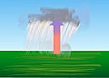
A Quantitative Precipitation Forecast (QPF) is the expected amount of liquid precipitation over a specific time and area. A QPF is issued when a measurable amount of precipitation is expected. These forecasts often align with specific times like 0000, 0600, 1200, and 1800 GMT. Forecasters consider the local terrain, like mountains, when making QPFs.
Since the mid-1990s, QPFs have been used in models to predict how much rivers will be affected by rainfall. Weather forecast models are very sensitive to how much humidity is in the lowest parts of the atmosphere. QPFs can either predict exact amounts of rain or the chance of a specific amount of rain. Radar images can help make more accurate forecasts within six to seven hours of the image being taken. Forecasters check their predictions using rain gauge measurements, weather radar estimates, or both.
See also
 In Spanish: Precipitación (meteorología) para niños
- List of meteorology topics
- Basic precipitation
- Bioprecipitation, the idea of bacteria helping to make rain.
- Mango showers, pre-monsoon rains in India that help mangoes ripen.
- Sunshower, when rain falls while the sun is shining.
- Wintry showers, a mix of rain, freezing rain, sleet, and snow.
Images for kids
-
Mean precipitation based on global climate data.
-
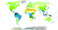
Countries by average yearly precipitation. Some parts of a country can be much wetter than others.
-
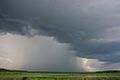
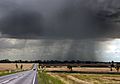
A thunderstorm with heavy precipitation.
-
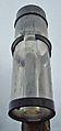
Standard rain gauge.
-
A summer rainstorm in Denmark.
-
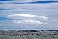
A lenticular cloud forming over mountains.
-
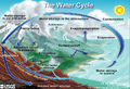
Condensation and coalescence are important parts of the water cycle.
-
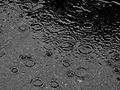
A puddle in the rain.
-
An accumulation of ice pellets.
-
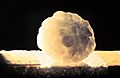
A large hailstone, about 6 centimeters (2.4 inches) across.
-
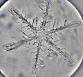
Snowflake viewed under a microscope.
-
Convective precipitation.
-
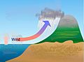
Orographic precipitation.
-
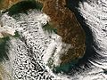
Lake-effect snow bands near the Korean Peninsula.
-
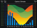
Rainfall distribution by month in Cairns showing the wet season.
-
.
Updated Köppen-Geiger climate map.
-
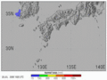
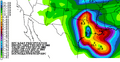
Rainfall estimates for southern Japan, July 20-27, 2009.
-
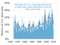
Extreme precipitation events have become more common in the U.S. over recent decades.
-
Image of Atlanta, Georgia, showing temperature distribution. Hot areas appear white.
-
Example of a five-day rainfall forecast.
