St. Francois County, Missouri facts for kids
Quick facts for kids
Saint Francois County
|
||
|---|---|---|

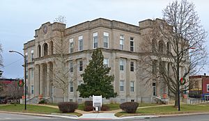
St. Francois County Courthouse in Farmington
|
||
|
||

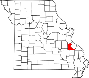
Location within the U.S. state of Missouri
|
||
 Missouri's location within the U.S. |
||
| Country | ||
| State | ||
| Founded | December 19, 1821 | |
| Named for | St. Francis River | |
| Seat | Farmington | |
| Largest city | Farmington | |
| Area | ||
| • Total | 455 sq mi (1,180 km2) | |
| • Land | 452 sq mi (1,170 km2) | |
| • Water | 2.8 sq mi (7 km2) 0.6% | |
| Population
(2020)
|
||
| • Total | 66,922 | |
| • Density | 147.08/sq mi (56.79/km2) | |
| Time zone | UTC−6 (Central) | |
| • Summer (DST) | UTC−5 (CDT) | |
| Congressional district | 8th | |
St. Francois County (pronounced FRAN-siss) is a county located in the Lead Belt area of Missouri, a state in the United States. In 2020, about 66,922 people lived there. The biggest city and the main government center is Farmington. The county was officially created on December 19, 1821. It was named after the St. Francis River. No one is completely sure how the river got its name. It might be named after Francis of Assisi, a famous saint. Another idea is that Jacques Marquette, an explorer, named it after Francis Xavier, a Jesuit missionary.
St. Francois County is part of the Farmington Micropolitan Statistical Area. This means it's a smaller city area that is also connected to the larger St. Louis region.
Contents
History
The County Seal
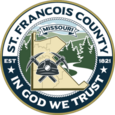
A county seal is like a special symbol or logo for the county government. From 2018 to 2022, St. Francois County used a different seal. This old seal became very famous online because many people thought it looked "overdone" or "amateurish." Some people, however, liked that it was unique.
The 2018 seal was quickly designed by a county leader named Harold Gallaher. It included parts from an even older seal from 1982. The county leaders all agreed to use this seal. It was put on government signs and vehicles.
The old seal had pictures like a bald eagle on the American flag, a pickaxe and shovel (showing mining history), a Bible and Christian cross, and an outline of the county. It also had the words "In God We Trust" and the county's founding date.
Because of all the attention, the county decided to hold a contest to design a new seal. Mr. Gallaher asked that the new design include references to the parks in the county and some parts from the old seal. Many people sent in their ideas. The winning design was created by Bryan Finch, a graphic designer from Farmington, Missouri.
Nearby Counties
- Jefferson County (north)
- Ste. Genevieve County (east)
- Perry County (southeast)
- Madison County (south)
- Iron County (southwest)
- Washington County (west)
Main Roads
Protected Areas
- Mark Twain National Forest (part of it is in the county)
Population Information
| Historical population | |||
|---|---|---|---|
| Census | Pop. | %± | |
| 1830 | 2,366 | — | |
| 1840 | 3,211 | 35.7% | |
| 1850 | 4,964 | 54.6% | |
| 1860 | 7,249 | 46.0% | |
| 1870 | 9,742 | 34.4% | |
| 1880 | 13,822 | 41.9% | |
| 1890 | 17,347 | 25.5% | |
| 1900 | 24,051 | 38.6% | |
| 1910 | 35,738 | 48.6% | |
| 1920 | 31,403 | −12.1% | |
| 1930 | 35,832 | 14.1% | |
| 1940 | 35,950 | 0.3% | |
| 1950 | 35,276 | −1.9% | |
| 1960 | 36,516 | 3.5% | |
| 1970 | 36,818 | 0.8% | |
| 1980 | 42,600 | 15.7% | |
| 1990 | 48,904 | 14.8% | |
| 2000 | 55,641 | 13.8% | |
| 2010 | 65,359 | 17.5% | |
| 2020 | 66,922 | 2.4% | |
| U.S. Decennial Census 1790-1960 1900-1990 1990-2000 2010-2015 |
|||
In 2000, there were 55,641 people living in St. Francois County. About 20,793 homes were counted. The population density was about 124 people per square mile.
The people living in the county were mostly White (96.14%). About 2.02% were African American. A small number were Native American, Asian, or from other backgrounds. About 0.80% of the population was Hispanic or Latino.
About 24% of the population was under 18 years old. The average age in the county was 37 years. For every 100 females, there were about 103 males.
Religion
St. Francois County is part of an area called the Bible Belt. This means that many people there follow evangelical Protestant religions. The largest groups are Southern Baptists, Roman Catholics, and Methodists. There are also some Orthodox Christian churches.
Catholic churches in the county include Immaculate Conception in Park Hills, St. Joseph in Farmington, St. Joseph in Bonne Terre, St. John in Bismarck, and St. Anne in French Village.
2020 Census
| Race | Num. | Perc. |
|---|---|---|
| White (NH) | 59,474 | 88.9% |
| Black or African American (NH) | 2,645 | 4% |
| Native American (NH) | 192 | 0.3% |
| Asian (NH) | 403 | 0.6% |
| Pacific Islander (NH) | 21 | 0.03% |
| Other/Mixed (NH) | 3,098 | 4.63% |
| Hispanic or Latino | 1,089 | 1.63% |
Education
Most adults (72.4%) in St. Francois County have a high school diploma or higher. About 10.2% have a bachelor's degree or higher.
Public Schools
- Bismarck R-V School District – Bismarck
- Bismarck Elementary School (Grades PK–6)
- Bismarck High School (Grades 7–12)
- Farmington R-VII School District – Farmington
- Jefferson Elementary School (Grades 1–4)
- Lincoln Intermediate School (Grades 5–6)
- Roosevelt Elementary School (Grades 1–4)
- Truman Learning Center (Grades PK-K)
- Washington-Franklin Elementary School (Grades 1–4)
- Farmington Middle School (Grades 7–8)
- Farmington High School (Grades 9–12)
- North St. Francois County R-I School District – Bonne Terre
- North St. Francois County Primary School (Grades PK–2) – Bonne Terre
- North St. Francois County Parkside Elementary School (Grades 3–4) – Desloge
- North St. Francois County Intermediate School (Grades 5–6) – Desloge
- North St. Francois County Middle School (Grades 7–8) – Desloge
- North St. Francois County High School (Grades 9–12) – Bonne Terre
- St. Francois County Central R-III School District – Park Hills
- Park Hills Central Elementary School (Grades K–2)
- West Elementary School (Grades 3–5)
- Park Hills Central Middle School (Grades 6–8)
- Park Hills Central High School (Grades 9–12)
- West St. Francois County R-IV School District – Leadwood
- West St. Francois County Elementary School (Grades PK–5) – Park Hills
- West St. Francois County Middle School (Grades 6–8) – Leadwood
- West St. Francois County High School (Grades 9–12) – Park Hills
Private Schools
- St. Paul Lutheran School – Farmington – (Grades PK–12) – A Lutheran Church–Missouri Synod school.
- St. Joseph School – Farmington – (Grades K–8) – A Roman Catholic school.
- St. Joseph Elementary School – Bonne Terre – (Grades PK–6) – A Roman Catholic school.
Other Schools
- Unitec Career Center – Bonne Terre – (Grades 10–12) – This school helps students learn job skills.
Colleges
- Mineral Area College – Park Hills – This is a public college where students can study for two years.
Public Libraries
- Bonne Terre Memorial Library
- Farmington Public Library
Communities
Cities
- Bismarck
- Bonne Terre
- Desloge
- Farmington (county seat)
- Iron Mountain Lake
- Leadington
- Leadwood
- Park Hills
Census-Designated Places
These are areas that are like towns but are not officially incorporated as cities.
Other Small Communities
See Also
 In Spanish: Condado de Saint François para niños


