Sanpete County, Utah facts for kids
Quick facts for kids
Sanpete County
|
|
|---|---|

Sanpete County Courthouse
|
|

Location within the U.S. state of Utah
|
|
 Utah's location within the U.S. |
|
| Country | |
| State | |
| Founded | January 31, 1850 |
| Named for | Chief Sanpitch |
| Seat | Manti |
| Largest city | Ephraim |
| Area | |
| • Total | 1,603 sq mi (4,150 km2) |
| • Land | 1,590 sq mi (4,100 km2) |
| • Water | 12 sq mi (30 km2) 0.8% |
| Population
(2020)
|
|
| • Total | 28,437 |
| • Density | 17.740/sq mi (6.8494/km2) |
| Time zone | UTC−7 (Mountain) |
| • Summer (DST) | UTC−6 (MDT) |
| Congressional districts | 2nd, 4th |
Sanpete County (/sænˈpiːt/ SAN-peet) is a county in the state of Utah. In 2020, about 28,437 people lived there. The main town, called the county seat, is Manti. The biggest city in the county is Ephraim. Sanpete County was officially created in 1850.
Contents
History of Sanpete County
Early People in Sanpete Valley
People have lived in the Sanpete Valley for a very long time. Hunters might have been here as far back as 32,000 years ago. These early groups used tools like atlatls (spear throwers) and millstones. They left the area about 2,500 years ago.
Later, around 1 to 1300 CE, the Fremont people lived here. They were the first to grow crops and build larger villages. A famous Fremont site in the county is "Witch's Knoll," near Ephraim. Around 1300 AD, the Fremont people also left.
The most recent Native American groups in the Sanpete area are the Ute, Paiute, Goshute, and Shoshoni tribes. They arrived in Utah around 1300 AD. These tribes speak similar languages from the Numic family.
Mormon Pioneers Arrive
Mormon pioneers came to the Great Salt Lake Valley in 1847. After setting up their main settlement, they started sending groups to other areas. In 1849, two Ute chiefs, Walkara and Sowiette, asked Mormon leader Brigham Young to send settlers to the Sanpitch Valley.
Brigham Young sent a group to explore the area. They liked what they saw. So, in November 1849, a group of 224 pioneers arrived. They were led by Isaac Morley and others. They decided to build their first town where Manti, Utah is today.
How the County Was Formed
The county was officially created on January 31, 1850. It was named after a Ute chief named Sanpitch. The name "Sanpete" comes from a Ute word meaning "people of the tules" (a type of plant).
Over the years, the county's borders changed many times. By 1880, Sanpete County was much larger than it is now. It included parts of what are now Carbon, Emery, Uintah, and Grand Counties. The county got its current shape after changes in 1913 and 1919.
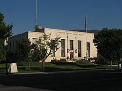
The Sanpete County Courthouse was finished in 1935. It was built during a time when the government created jobs to help people. This building is now on the National Register of Historic Places, which means it's an important historical site.
Geography of Sanpete County
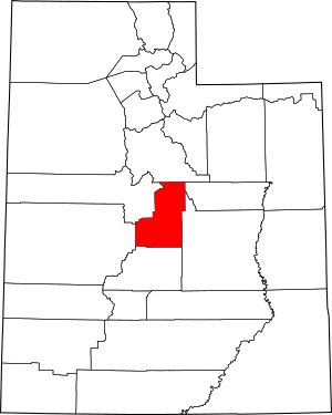
Sanpete County has a long valley that runs from north to south. The land slopes gently towards the south. The highest point is South Tent Mountain, which is about 11,285 feet (3,440 meters) high. The county covers about 1,603 square miles (4,152 square kilometers). Most of this is land, with a small amount of water. The exact center of Utah is located in Sanpete County, near Ephraim.
Mountains and Rivers
The eastern side of Sanpete County is bordered by the Wasatch Plateau. These mountains are very tall, reaching about 11,000 feet (3,350 meters). Much of this area is part of the Manti-La Sal National Forest. Water from these mountains flows down to supply the towns and farms in the county.
The middle of the county is the Sanpete Valley, where most of the towns are. To the west, there are the lower and drier San Pitch Mountains. The San Pitch River flows through the valley from north to south. It eventually joins the Sevier River in the southwestern part of the county.
Major Roads
- United States Highway US-89
- Utah State Highway UT-28
- Utah State Highway UT-31
- Utah State Highway UT-116
- Utah State Highway UT-132
- Utah State Highway UT-137
- Utah State Highway UT-264
Neighboring Counties
- Utah County - north
- Carbon County - northeast
- Emery County - east
- Sevier County - south
- Millard County - southwest
- Juab County - northwest
Protected Natural Areas
- Bald Mountain Wildlife Management Area
- Fishlake National Forest (part)
- Hilltop Wildlife Management Area
- Manti-La Sal National Forest (part)
- Manti Wildlife Management Area
- Mayfield Face Wildlife Management Area
- Palisade State Park
- Spring City Wildlife Management Area
- Uinta-Wasatch-Cache National Forest (part)
- Yuba State Park
People of Sanpete County
| Historical population | |||
|---|---|---|---|
| Census | Pop. | %± | |
| 1850 | 365 | — | |
| 1860 | 3,815 | 945.2% | |
| 1870 | 6,786 | 77.9% | |
| 1880 | 11,557 | 70.3% | |
| 1890 | 13,146 | 13.7% | |
| 1900 | 16,313 | 24.1% | |
| 1910 | 16,704 | 2.4% | |
| 1920 | 17,505 | 4.8% | |
| 1930 | 16,022 | −8.5% | |
| 1940 | 16,063 | 0.3% | |
| 1950 | 13,891 | −13.5% | |
| 1960 | 11,053 | −20.4% | |
| 1970 | 10,976 | −0.7% | |
| 1980 | 14,620 | 33.2% | |
| 1990 | 16,259 | 11.2% | |
| 2000 | 22,763 | 40.0% | |
| 2010 | 27,822 | 22.2% | |
| 2020 | 28,437 | 2.2% | |
| US Decennial Census 1790–1960 1900–1990 1990–2000 2010 2020 |
|||
Population in 2020
In 2020, Sanpete County had 28,437 people. This means there were about 17.9 people living in each square mile. Most people (83.3%) were White. About 10.7% of the people were Hispanic or Latino.
There were more males (53.68%) than females (46.32%). About 28.1% of the population was under 18 years old. The average age of people in the county was 33.7 years.
There were 8,394 households. Most of these (76.9%) were families. About 64.2% of families were married couples. Most households (77.1%) owned their homes.
The average income for a household in Sanpete County was $55,820 per year. About 14.8% of the people lived below the poverty line.
When it comes to education, about 31.6% of adults had a high school diploma. About 39.6% had some college or an associate degree. Many people also had a bachelor's degree or a graduate degree.
Economy of Sanpete County
Sanpete County is mostly a farming area. Its economy relies on agriculture, raising animals, small businesses, government jobs, and Snow College.
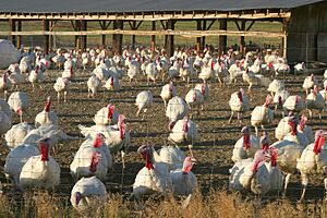
A very important industry here is raising turkeys. The Moroni Feed Company is a big turkey farm and processing business. They are part of a larger company called Norbest. Moroni Feed Company has many parts, including a turkey processing plant, a place where turkey eggs hatch, and a feed mill. They employ over 600 people. You can see many turkey barns around towns like Moroni.
Growing Alfalfa and other crops to feed animals is also a major part of the county's farming economy.
Communities in Sanpete County
Cities
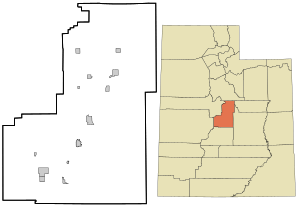
- Centerfield
- Ephraim
- Fairview
- Fountain Green
- Gunnison
- Manti (county seat)
- Moroni
- Mount Pleasant
- Spring City
Towns
Unincorporated Communities
These are places that are not officially cities or towns.
Ghost Towns
These are towns that used to exist but are now abandoned.
Education in Sanpete County
Sanpete County has two main school districts: the North Sanpete School District and the South Sanpete School District.
See also
 In Spanish: Condado de Sanpete para niños


