
Shawangunk Ridge facts for kids
Quick facts for kids Shawangunk Ridge |
|
|---|---|
| Shawangunk Mountains | |

Shawangunk Ridge from Sky Top cliff
|
|
| Highest point | |
| Peak | High Point |
| Elevation | 2,289 ft (698 m) |
| Dimensions | |
| Length | 47 mi (76 km) north–south |
| Geography | |
| Country | United States |
| State | New York |
| Geology | |
| Age of rock | Silurian (440 to 417 (±10) million years ago) |
| Type of rock | Shawangunk Formation; sedimentary |

The Shawangunk Ridge, also called the Shawangunk Mountains or simply The Gunks, is a long, rocky ridge in New York State. It stretches through Ulster, Sullivan, and Orange counties. This ridge starts in northern New Jersey and reaches all the way to the Catskill Mountains.
The Shawangunk Ridge is part of the easternmost chain of the Appalachian Mountains. In New Jersey, it's known as Kittatinny Mountain, and in Pennsylvania, it's called Blue Mountain. This ridge forms the western edge of the large Great Appalachian Valley.
The top of the ridge is wide, especially at its northern end. It has many protected areas for nature and isn't very crowded. The only notable town on the ridge is Cragsmoor. Long ago, people used the ridge for mining, cutting down trees, and picking huckleberries. They even set fires to help new huckleberry bushes grow.
Today, the Shawangunk Ridge is famous for outdoor fun. It's one of North America's top spots for rock climbing, with many guides ready to help you explore. The ridge is also special for its amazing variety of plants and animals, and its beautiful scenery. Because of its unique nature, The Nature Conservancy has marked it as an important area to protect.
Contents
What's in a Name? The Shawangunk Story
The name "Shawangunk" comes from the Dutch word Scha-wan-gunk. This was their way of writing the name given by the Munsee Lenape people, Schawankunk.
A Lenape language expert, Raymond Whritenour, says that schawan means "it is smoky air" or "there is smoky air." So, schawangunk means "in the smoky air."
One idea is that the name came from a time in 1663 when the Dutch burned a Munsee fort at the base of the ridge. This event ended the Second Esopus War. After the war, the name quickly appeared in many land records.
Historian Marc B. Fried suggests two possibilities for the name. It could have been the Lenape's own name for their village and fort. Or, it might have been a new name the Lenape created to describe something about the land. The name "Shawangunk" became linked to the ridge during the 1700s.
The original Lenape word has three syllables: Sha-wan-gun. The "k" sound at the end is very soft. Over time, European settlers shortened "Shawangunk" to "Shongum." This shorter name is still popular among local people.
Another common nickname for the ridge is "The Gunks." This name has been used since at least the mid-1800s. Famous painter Thomas Cole even used it in a letter in 1838. He wrote, "Do let me hear from you when you get among the Gunks." The Shawangunks were a favorite subject for many artists of the Hudson River School.
Where Are the Shawangunk Mountains?
The Shawangunk Ridge is the northern tip of a long mountain chain. This chain starts far south in Virginia, where it's called North Mountain. It continues through Pennsylvania as Blue Mountain. After crossing the Delaware Water Gap into New Jersey, it becomes the Kittatinny Mountains. Finally, it turns into the Shawangunks when it reaches New York. These mountains form the western and northern edge of the Great Appalachian Valley.
The ridge is widest near its northern end, about 7.5 miles (12.1 km) across. In the middle, it narrows to about 1.25 miles (2.01 km). The highest point is 2,289 feet (698 m) near Lake Maratanza. To the east, the ridge rises above a flat plain that stretches to the Hudson River. To the west, there are lower hills and flat areas with rivers like the Rondout Creek and Delaware River. These valleys are made of softer rocks like sandstone and shale.
Amazing Plants and Habitats
The Shawangunk Ridge has an amazing variety of plants. You can find plants that usually grow far north of this area, as well as plants from the south or coastal regions. This means many rare plants grow here, often at the edge of their natural range. Other rare plants are special because they can survive the tough conditions on the ridge.
High up on the ridge, you'll find forests with chestnut oak and other oak trees. There are also pine barrens with small, dwarf pine trees. Some areas have hemlock and northern hardwood forests. You can also see plants growing on cliffs, rocky slopes, and in caves.
Wetlands on the ridge include small lakes and streams. There are also bogs, pitch pine-blueberry swamps, and even a rare Atlantic white cypress swamp. Other wet areas include red maple swamps and various types of wet seeps.
How the Shawangunk Ridge Formed

The Shawangunk Ridge is mostly made of a very hard rock called Shawangunk Conglomerate. This rock is like concrete, made of white quartz pebbles and sandstone glued together by silica. This hard rock sits on top of an older, softer rock layer called the Martinsburg Formation, which is made of dark gray shale.
The Martinsburg Formation formed in a deep ocean about 470 million years ago. The Shawangunk Conglomerate formed about 420 million years ago from thick river deposits. Later, about 270 million years ago, a huge event happened. Continents collided to form the Pangea supercontinent. This collision pushed and folded the rock layers of the ridge.
The Shawangunk Conglomerate is very strong and doesn't wear away easily. But the softer shale underneath erodes more quickly. This is why the ridge has dramatic cliffs and rocky slopes, especially on its eastern side.
During the last Ice Age, huge glaciers covered the entire ridge. They scraped the rocks, left behind piles of dirt and rocks, and pushed large rock blocks off the eastern side. The soil on top of the ridge is usually thin, acidic, and dry. But in low spots where water collects, you can find lakes and wetlands.
Cool Ice Caves
Ice caves are deep cracks in the hard rock of the ridge. These cracks are so deep that they can hold ice through most of the summer! This creates a very cool, damp environment. Because of this, you can find plants that usually grow in much colder northern areas. These include black spruce, hemlock, rowan, and creeping snowberry.
These ice caves are mostly found near Sam's Point in the northern part of the Shawangunks. There are also larger limestone caves on the lower slopes of the Rondout and Delaware River valleys.
The Sky Lakes
Lakes and wetlands are common on the flat tops of the northern and southern parts of the ridge. The lakes on the hard conglomerate rock are usually clear, low in nutrients, and very acidic. This is because the rock doesn't help balance the water's acidity.
The northern Shawangunks have five special lakes called the "sky lakes." From north to south, they are: Mohonk Lake, Lake Minnewaska, Lake Awosting, Mud Pond, and Lake Maratanza. Four of these lakes are quite acidic. However, Mohonk Lake is less acidic because it sits partly on softer shale rock, which helps balance its pH.
Parks and Preserves to Explore

The Shawangunks have many public lands for everyone to enjoy, along with a few small towns. A large part of the northern ridge is protected by Minnewaska State Park Preserve. This park also manages Sam's Point Preserve. Together, they offer over 100 miles (160 km) of hiking trails and several rock climbing spots.
The Mohonk Preserve, started in 1963, protects over 8,000 acres of the Shawangunk Ridge. This includes the famous Trapps climbing cliffs. It also has over 70 miles of old carriage roads and trails for hiking and biking. In 2007, Shawangunk Ridge State Forest and Witches Hole State Forest were added to the protected areas.
The Long Path, a long-distance hiking trail, follows the ridge from Sullivan County up to Kerhonkson. South of that, the Shawangunk Ridge Trail connects to the Appalachian Trail near High Point. There are also several old carriage trails on the ridge, like Smiley Road and Old Plank Road. Many of the hiking trails are kept in good shape by the New York-New Jersey Trail Conference.
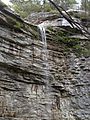
The Shawangunk region also has many beautiful waterfalls. Some of these include VerKeerderkill Falls, Awosting Falls, and Vernooy Kill Falls.
In 2004, there was a plan to build luxury homes on the ridge. People in the area started a "Save the Ridge" campaign to protect it. In 2006, a court ordered the land to be sold. The Open Space Institute of New York bought the land and gave it to Minnewaska State Park Preserve. This helped protect a large part of the ridge for future generations.
It's important to know that while many areas are public, the Mohonk Preserve is a private land trust. This means you usually need to pay a small fee to use its trails and climbing areas.
Fun Things to Do on the Ridge
Hiking Adventures
The Shawangunk Ridge Trail is a great way to explore the area. It goes north for about 40 miles (64 km) from the Appalachian Trail in New Jersey to Sam's Point Preserve in New York. The trail often follows the beautiful ridge, sometimes using old roads or railway beds. The New York/New Jersey Trail Conference lists seventeen different hikes you can enjoy on the ridge.
Rock Climbing Excitement

The Shawangunks are famous for Rock climbing. Early climbers like Fritz Wiessner and Hans Kraus helped make it popular. Climbing here is mostly focused on four main cliffs: Millbrook, the Near Trapps, The Trapps, and Skytop.
The Trapps is the longest, most popular, and easiest to reach. It has the most climbing routes. The Near Trapps is right across the road from The Trapps and is also very popular. Millbrook mountain is the highest and furthest south, so fewer people climb there. The Skytop cliff belongs to the Mohonk Mountain House, and you need an authorized guide to climb there. You can also climb at the Peterskill and Dickie Barre areas in Minnewaska State Park Preserve. The cliffs can be up to 300 feet (91 m) high!
Images for kids
-
Awosting Falls in Minnewaska State Park Preserve. The cliff is made of layers of conglomerate.
