
Grand Forks, North Dakota facts for kids
Quick facts for kids
Grand Forks, North Dakota
|
||
|---|---|---|
|
Aerial View of Downtown Grand Forks (2006)
St. Michael's Church
|
||
|
||
| Nickname(s):
"The Grand Cities", "The Forks"
|
||
| Motto(s):
"A Place of Excellence"
|
||

Location in the U.S. state of North Dakota
|
||

Grand Forks, North Dakota
Location in North Dakota

Grand Forks, North Dakota
Location in the United States
|
||
| Country | United States | |
| State | North Dakota | |
| Metro | Greater Grand Forks | |
| County | Grand Forks | |
| Founded | June 15, 1870 | |
| Incorporated | February 22, 1881 | |
| Area | ||
| • City | 29.318 sq mi (75.933 km2) | |
| • Land | 29.120 sq mi (75.422 km2) | |
| • Water | 0.198 sq mi (0.514 km2) | |
| Elevation | 837 ft (255 m) | |
| Population
(2020)
|
||
| • City | 59,166 | |
| • Estimate
(2023)
|
58,921 | |
| • Rank | US: 667th ND: 3rd |
|
| • Density | 2,028.22/sq mi (783.11/km2) | |
| • Urban | 68,160 (US: 411st) | |
| • Urban density | 2,573.67/sq mi (993.69/km2) | |
| • Metro | 103,120 (US: 357th) | |
| • Metro density | 30.3/sq mi (11.69/km2) | |
| Time zone | UTC–6 (Central (CST)) | |
| • Summer (DST) | UTC–5 (CDT) | |
| ZIP Codes |
58201, 58202, 58203, 58204, 58205, 58206, 58207, 58208
|
|
| Area code(s) | 701 | |
| FIPS code | 38-32060 | |
| GNIS feature ID | 1036064 | |
| Highways | I-29, US 2, US 81, ND 297 | |
| Sales tax | 7.25% | |


Grand Forks is a city in North Dakota, United States. It is the main city of Grand Forks County. In 2020, about 59,166 people lived there. This makes it the third-largest city in North Dakota, after Fargo and Bismarck. Grand Forks is often called "The Grand Cities" or "The Forks." It is connected to its "twin city," East Grand Forks, Minnesota, which is just across the river in Minnesota. Together, they form the Greater Grand Forks area.
The city sits on the western side of the Red River of the North. This river flows north through a very flat area called the Red River Valley. Because the land is so flat, the city can experience floods. A big flood in 1997 caused a lot of damage. French fur traders from Canada first called the area Les Grandes Fourches, meaning "The Grand Forks." This name came from where the Red River and the Red Lake River meet. The city was officially started on June 15, 1870, and became a town on February 22, 1881.
Grand Forks used to rely mostly on farming. Now, its economy is much more varied. It includes important areas like higher education, defense, healthcare, manufacturing, food processing, and scientific research. The city has its own airport, Grand Forks International Airport, and an Air Force base. The University of North Dakota in Grand Forks is the oldest university in the state. Large venues like the Alerus Center and Ralph Engelstad Arena host sports and other events. The Empire Arts Center and Chester Fritz Auditorium are major places for cultural events.
Contents
History of Grand Forks

For thousands of years, the area where Grand Forks is now was an important meeting and trading spot for Native American tribes. French explorers and fur traders later came to this area. They called it Les Grandes Fourches, which means "The Grand Forks." By the 1740s, this spot was a key trading post for French fur traders.
The United States gained this land in 1818. However, Native American tribes mostly controlled the area until the late 1800s. After some conflicts, the U.S. made agreements with tribes like the Ojibwe to gain control of the land. When a U.S. post office opened here on June 15, 1870, the name was changed to "Grand Forks." Alexander Griggs, a steamboat captain, is known as "The Father of Grand Forks." His steamboat got stuck in the frozen Red River in late 1870, so he and his crew had to spend the winter there. Griggs then planned out the community in 1875, and Grand Forks officially became a town on February 22, 1881.
Many settlers moved to the Dakota Territory in the 1870s and 1880s because land was cheap. The city grew quickly after the Great Northern Railway arrived in 1880 and the Northern Pacific Railway in 1887. In 1883, the University of North Dakota was started. This was six years before North Dakota became a state. In 1887, Grand Forks was hit by one of North Dakota's deadliest tornadoes, which killed at least six people.
In the first half of the 1900s, new homes were built south and west of downtown Grand Forks. In the 1920s, the state-owned North Dakota Mill and Elevator was built on the north side of the city. This is the largest flour mill in the nation.
In 1954, Grand Forks was chosen for an Air Force base. The Grand Forks Air Force Base brought many new jobs and people to the city. The base and the University of North Dakota became very important to the city's economy. After World War II, new roads and shopping areas were built, spreading the city out. Interstate 29 was built on the west side of the city, and two large shopping malls, South Forks Plaza and Columbia Mall, were built on the south side.

The Red River has often flooded, especially because the area is a flat ancient lake bed. The 1997 Red River flood caused huge damage in Grand Forks. During the flood, a big fire also destroyed 11 buildings downtown. After this, the government built a new levee system to protect the city. This system was finished 10 years later and required moving some neighborhoods.
The land along the Red River that used to flood was turned into a big park called the Greater Grand Forks Greenway. This park offers new places for fun and helps the land soak up future floodwaters naturally.
Since the 1997 flood, Grand Forks has continued to grow. Two new, large sports venues, the Alerus Center and the Ralph Engelstad Arena, opened in 2001. In 2007, a 13-story hotel and waterpark connected to the Alerus Center opened. By 2007, Grand Forks had more people, jobs, and sales than before the flood.
Geography and Landscape


Grand Forks is about 74 miles (119 km) north of Fargo and 145 miles (233 km) south of Winnipeg, Manitoba, Canada. The city is on the western bank of the Red River of the North. The name "forks" comes from where the Red River meets the Red Lake River near downtown. The city covers about 29.3 square miles (75.9 sq km), with most of it being land.
Grand Forks is in one of the flattest places in the world, so there are not many hills. There are no lakes within the city, but the winding Red River and the English Coulee flow through it. The flat Red River Valley was formed by an ancient glacier and a large glacial lake called Lake Agassiz. You can still see the ancient lake beaches as small rolling hills west of the city.
City Neighborhoods

Grand Forks has several different neighborhoods. The oldest areas, including downtown, grew first along the Red River. The area between downtown and the University of North Dakota campus also developed early and has many historic buildings.
Downtown Grand Forks has many old and important buildings. It is the center for city and county government. It's also a popular place for community events and festivals. A farmer's market is held there every Saturday from mid-June to mid-September.
In 2006, city leaders planned to turn old office buildings into modern condos and apartments downtown. South of downtown, the Near Southside Historic District has streets lined with classic houses. Reeves Drive used to be a very fancy neighborhood with many historic mansions. This area has old granitoid paving, historic churches, and Lincoln Drive Park. The Near Southside neighborhood is now a "national historic district."
Newer neighborhoods are mostly in the southern and western parts of Grand Forks. The 32nd Avenue South area has been a major shopping center since the Columbia Mall opened in 1978. Many large stores and restaurants are now along this avenue. The Grand Forks Marketplace, a big shopping center, opened in 2001 near the Columbia Mall.
University Village is a new shopping area built on land owned by the University of North Dakota. The main building there is the Ralph Engelstad Arena, used by the university's hockey team. All buildings in the Village look similar to those on the nearby UND campus. Restaurants, shops, and the university bookstore are in this area. In 2006, the university opened a new wellness center for students in the Village.
Climate and Weather
Grand Forks has four very clear seasons. Temperatures can change a lot in a short time. Because it's in the flat Red River Valley, the city often has windy weather all year. It can also experience spring floods from the Red River.
Winters in Grand Forks are long, very cold, and snowy. Summers are often warm to hot and humid, with many thunderstorms. Spring and autumn are short and changeable. The coldest temperature ever recorded was -43°F (-41.7°C) in 1912. The hottest was 109°F (42.8°C) in 1936. Even in summer, it has sometimes been cold enough to freeze.
| Climate data for Grand Forks, North Dakota (1981–2010 normals) | |||||||||||||
|---|---|---|---|---|---|---|---|---|---|---|---|---|---|
| Month | Jan | Feb | Mar | Apr | May | Jun | Jul | Aug | Sep | Oct | Nov | Dec | Year |
| Record high °F (°C) | 52 (11) |
67 (19) |
83 (28) |
100 (38) |
105 (41) |
105 (41) |
109 (43) |
104 (40) |
103 (39) |
95 (35) |
75 (24) |
58 (14) |
109 (43) |
| Mean daily maximum °F (°C) | 16.5 (−8.6) |
21.9 (−5.6) |
34.2 (1.2) |
53.9 (12.2) |
68.0 (20.0) |
76.1 (24.5) |
81.0 (27.2) |
80.2 (26.8) |
69.6 (20.9) |
54.3 (12.4) |
35.1 (1.7) |
20.3 (−6.5) |
50.9 (10.5) |
| Mean daily minimum °F (°C) | −3.1 (−19.5) |
2.1 (−16.6) |
16.1 (−8.8) |
30.0 (−1.1) |
41.5 (5.3) |
52.0 (11.1) |
56.3 (13.5) |
54.0 (12.2) |
44.2 (6.8) |
31.9 (−0.1) |
17.0 (−8.3) |
2.6 (−16.3) |
28.7 (−1.8) |
| Record low °F (°C) | −43 (−42) |
−42 (−41) |
−36 (−38) |
−9 (−23) |
5 (−15) |
28 (−2) |
30 (−1) |
30 (−1) |
11 (−12) |
−9 (−23) |
−35 (−37) |
−37 (−38) |
−43 (−42) |
| Average precipitation inches (mm) | 0.55 (14) |
0.52 (13) |
0.95 (24) |
1.01 (26) |
2.68 (68) |
3.48 (88) |
3.15 (80) |
2.88 (73) |
2.05 (52) |
1.92 (49) |
0.96 (24) |
0.61 (15) |
20.76 (527) |
| Average snowfall inches (cm) | 11.2 (28) |
6.5 (17) |
7.5 (19) |
2.9 (7.4) |
0.1 (0.25) |
0 (0) |
0 (0) |
0 (0) |
0 (0) |
1.4 (3.6) |
7.6 (19) |
10.6 (27) |
47.7 (121) |
| Average precipitation days (≥ 0.01 in) | 8.2 | 6.6 | 7.5 | 7.0 | 10.6 | 11.6 | 10.5 | 9.1 | 8.3 | 8.5 | 6.9 | 8.5 | 103.3 |
| Average snowy days (≥ 0.1 in) | 10.6 | 7.0 | 5.7 | 2.1 | 0.2 | 0 | 0 | 0 | 0 | 1.3 | 5.6 | 9.7 | 42.2 |
| Source: NOAA (extremes 1893–present) | |||||||||||||
Population and People
| Historical population | |||
|---|---|---|---|
| Census | Pop. | %± | |
| 1880 | 1,705 | — | |
| 1890 | 4,979 | 192.0% | |
| 1900 | 7,682 | 54.3% | |
| 1910 | 12,478 | 62.4% | |
| 1920 | 14,010 | 12.3% | |
| 1930 | 17,112 | 22.1% | |
| 1940 | 20,228 | 18.2% | |
| 1950 | 26,836 | 32.7% | |
| 1960 | 34,451 | 28.4% | |
| 1970 | 39,008 | 13.2% | |
| 1980 | 43,765 | 12.2% | |
| 1990 | 49,425 | 12.9% | |
| 2000 | 49,321 | −0.2% | |
| 2010 | 52,838 | 7.1% | |
| 2020 | 59,166 | 12.0% | |
| 2023 (est.) | 58,921 | 11.5% | |
| U.S. Decennial Census 2020 Census |
|||
In 2022, Grand Forks had about 25,487 households, with an average of 2.15 people per household. The average household income was $59,079. About 16.4% of the people in the city live below the poverty line. About 70.1% of people have jobs. Also, 39.0% of the population has a bachelor's degree or higher, and 95.5% have a high school diploma.
The most common backgrounds reported by people were German (28.3%), Norwegian (25.6%), and Irish (8.1%). The average age in the city was 29.1 years old.
Population Changes (2020 Census)
| Race / ethnicity (NH = non-Hispanic) | Pop. 2000 | Pop. 2010 | Pop. 2020 | % 2000 | % 2010 | % 2020 |
|---|---|---|---|---|---|---|
| White alone (NH) | 45,534 | 46,525 | 46,635 | 92.32% | 88.05% | 78.82% |
| Black or African American alone (NH) | 412 | 1,037 | 2,782 | 0.84% | 1.96% | 4.70% |
| Native American or Alaska Native alone (NH) | 1,314 | 1,458 | 1,528 | 2.66% | 2.76% | 2.58% |
| Asian alone (NH) | 471 | 1,169 | 2,356 | 0.95% | 2.21% | 3.98% |
| Pacific Islander alone (NH) | 28 | 19 | 31 | 0.06% | 0.04% | 0.05% |
| Other race alone (NH) | 28 | 26 | 148 | 0.06% | 0.05% | 0.25% |
| Mixed race or multiracial (NH) | 613 | 1,131 | 2,733 | 1.24% | 2.14% | 4.62% |
| Hispanic or Latino (any race) | 921 | 1,473 | 2,953 | 1.87% | 2.79% | 4.99% |
| Total | 49,321 | 52,838 | 59,166 | 100.00% | 100.00% | 100.00% |
In 2020, there were 59,166 people living in Grand Forks. There were 25,446 households and 12,305 families. The city had about 2,122 people per square mile (819 per sq km). The population was 80.62% White, 4.77% African American, 2.84% Native American, and 4.01% Asian. People of Hispanic or Latino background made up 4.99% of the population.
Economy and Jobs
The economy of Grand Forks is quite varied. It is not controlled by just one type of business. While farming is still important, the city also has jobs in education, defense, healthcare, manufacturing, and food processing. The state and federal governments are two of the biggest employers. The University of North Dakota is the largest employer in the area. Grand Forks Air Force Base also employs many people. Altru Health System is the largest private employer.
Major Employers in Grand Forks
Here are the largest employers in Grand Forks, based on a 2022 report:
| # | Employer | Number of employees |
|---|---|---|
| 1 | University of North Dakota | 5,562 |
| 2 | Altru Health System | 3,400 |
| 3 | Grand Forks Air Force Base | 2,897 |
| 4 | Grand Forks Public Schools | 1,700 |
| 5 | City of Grand Forks | 831 |
| 6 | Valley Memorial Home | 818 |
| 7 | LM Wind Power | 560 |
| 8 | Development Homes | 480 |
| 9 | Hugo's (4 locations) | 460 |
| 10 | J.R. Simplot | 440 |
| Total | — | 17,148 |

Big manufacturers in Grand Forks include LM Wind Fiber, which makes wind turbine parts, and Cirrus Design, which makes small airplanes. Major food companies include J. R. Simplot Company, which processes potatoes, and the state-owned North Dakota Mill and Elevator, the largest flour mill in the country.
The city also has many retail stores and service businesses. The historic downtown area has small shops, bars, and restaurants. The south side of Grand Forks is another big shopping area with three large centers. The Columbia Mall is the biggest indoor mall with about 70 stores. The Grand Forks Marketplace is a newer shopping center with several large stores. Many shoppers from Manitoba, Canada, also visit Grand Forks.
Growing the Economy
The city government helps businesses grow and attracts new ones. A part of sales tax money goes into the Grand Forks Growth Fund. Companies can get low-interest loans or grants from this fund if they meet certain rules, like paying good wages. The city also supports the Grand Forks Region Economic Development Corporation (EDC). This group helps businesses find good locations and get funding.
Leaders see the University of North Dakota as a key part of the city's economy. Besides its teaching, the university has research centers like the Energy and Environmental Research Center. UND also has a technology incubator called the Center for Innovation. The university is working to turn its research into new businesses. A new research park is being built near the campus to help with this. Another exciting opportunity is the addition of unmanned aerial vehicle (UAV) operations at Grand Forks Air Force Base.
Culture and Fun
Arts and Theatre Scene
Grand Forks has many arts and cultural events, partly because of the University of North Dakota. The North Dakota Museum of Art, on the UND campus, brings national art exhibits and shows work by local artists. UND also has art galleries for student art. The university's Theater Arts and Music departments put on plays and concerts each year. The Chester Fritz Auditorium at UND hosts music and theatre events, including national touring Broadway shows.
The Greater Grand Forks Symphony Orchestra has been performing since 1905. The Grand Forks Master Chorale started in 1983. Both groups perform shows every year. The North Dakota Ballet Company is based in Grand Forks and often performs at the Chester Fritz Auditorium. The Grand Forks City Band, formed in 1886, still performs year-round.
The Empire Arts Center in downtown Grand Forks hosts many cultural events. The Empire, an old movie theatre from 1919, was fixed up after the 1997 flood. It now has a performance space, a large movie screen, an art gallery, and artist studios. The Fire Hall Theatre, also downtown, is used by community members for plays. The Summer Performing Arts Company (SPA) is a popular summer program for K–12 students. SPA puts on three big musicals in July. The Myra Museum, near the Greater Grand Forks Greenway, is a small history museum. It shows local history from the Ice Age to today. Other buildings at the Myra Museum include the original 1868 Grand Forks Post Office and a 1917 one-room school.
Sports and Athletics

College sports are very popular in Grand Forks, especially for the University of North Dakota teams. The UND men's ice hockey team plays in NCAA Division I. They have won the Frozen Four championship eight times. The UND football team won the 2001 NCAA Division II national championship. In 2006, the university decided to move all its sports programs to Division I.
Grand Forks has two major indoor sports arenas. The city-owned Alerus Center opened in 2001. It is home to the University of North Dakota football team and hosts many other events, including big concerts. The Alerus Center is the largest arena and convention center in the upper Midwest. The University of North Dakota hockey teams play in the Ralph Engelstad Arena. This arena, often called "The Ralph," was built in 2001 for over $100 million. Next to "The Ralph" is the smaller Betty Engelstad Sioux Center, where the university's basketball and volleyball teams play.
Outdoor Recreation

The Grand Forks Park District, started in 1905, manages 14 neighborhood parks, 28 tennis courts, 2 swimming pools, and 3 splash parks. These parks have playgrounds, baseball fields, soccer fields, basketball courts, and picnic areas. Sertoma Park has a Japanese garden. The Park District also runs eleven outdoor skating rinks and several indoor ice arenas.
There are several golf courses in and around the city. The Park District runs the 18-hole King's Walk Golf Course and the 9-hole Lincoln Golf Course. The University of North Dakota used to have the 9-hole Ray Richards Golf Course, which reopened in 2020. The 18-hole Grand Forks Country Club is just south of the city.
The Greater Grand Forks Greenway is a large park along the Red River. It has many paths, festival grounds, ski trails, and wildflower gardens. Including the Greenway, the Andrew Hampsten Bikeway System in Grand Forks is over 43 miles (69 km) long. These paths are in the Greenway, next to main streets, and along the English Coulee. There are also two bridges for walking and biking that cross the Red River, connecting paths in Grand Forks and East Grand Forks.
Education System
Higher Education Opportunities
The University of North Dakota (UND) is in Grand Forks. It is the oldest university in the state and has North Dakota's only medical and law schools. UND is well-known for its John D. Odegard School of Aerospace Sciences. This school has an Air Traffic Control Training program that was ranked number one in the nation by the FAA in 2009. UND and North Dakota State University work together in the Red River Valley Research Corridor.
Northland Community and Technical College, a two-year school, is across the Red River in East Grand Forks. The University of Minnesota Crookston is also nearby in Crookston, Minnesota.
Schools for Kids
The Grand Forks Public Schools system includes schools in Grand Forks and at the Grand Forks Air Force Base. Most of Grand Forks is in the Grand Forks Public School District 1. About 7,400 students attend these schools. There are ten elementary schools, one school that combines elementary and middle school (Twining), three middle schools (Schroeder, South, and Valley), and two high schools (Central High and Red River High). There is also an alternative high school and an adult education program. A board of nine elected members manages the public schools.
There are also some private schools. The state runs the North Dakota School for the Blind. There are two Catholic schools for kindergarten through sixth grade. The only private high school in the area is Sacred Heart High School, a Catholic school in East Grand Forks. There is also a Christian elementary and middle school in East Grand Forks.
Six of the city's Mid-Century Modern-style schools were added to the National Register of Historic Places in 2020 because of their unique architecture.
Media and News

The Grand Forks Herald is the main daily newspaper for Grand Forks. It is the second most popular newspaper in North Dakota, with about 31,000 copies printed daily. The Exponent is a weekly newspaper published in East Grand Forks, Minnesota. The University of North Dakota also has its own student newspaper, The Dakota Student, published twice a week during the school year.
Grand Forks has several radio stations. KNOX 1310 AM (also on 107.9 FM) is a news and talk station. KWTL 1370 AM (also on 92.5 FM) broadcasts Catholic programming. Other AM stations include sports station KKXL-AM 1440, classic rock station KGFK 1590 (also on 95.7 FM), and news/talk KROX 1260 (also on 92.1 FM).
FM stations include NPR affiliates KUND-FM 89.3, KFJM 90.7, KQMN 91.5, and KNTN 102.7. Other FM stations include K-Love's K237ER 95.3, 3ABN's KOBT-LP 101.3, active rock station KJKJ 107.5, top 40/CHR stations KKXL-FM 92.9 and KZGF 94.7, country stations KSNR 100.3 and KYCK 97.1, adult contemporary station KZLT-FM 104.3, contemporary Christian music station KKEQ (K285BG) 104.9, and classic hits station KQHT 96.1.
Grand Forks is part of the Fargo television market. Major TV channels include WDAZ-TV (ABC), K30LR-D (CBS), KBRR-TV (FOX), and KVLY-TV (NBC).
City Services and Travel
Getting Around Grand Forks

Public Transportation
The city has a bus system called Cities Area Transit (CAT). It started in 1926, replacing an older streetcar system. There are 12 bus routes, including night service and service to East Grand Forks. You can also travel between cities by bus using Jefferson Lines.
Train Travel
The BNSF Railway has train tracks in and around the city. Amtrak passenger trains on the Empire Builder line stop at the Grand Forks Amtrak station. Trains head west daily at 5:34 am and east daily at 2:10 am.
Air Travel
Grand Forks International Airport (GFK) has flights from Delta Air Lines to Minneapolis-St. Paul International Airport. Allegiant Air also offers flights a few times a week to places like Mesa, Arizona, Sanford, Florida, and Las Vegas, Nevada. A new passenger terminal opened in 2011 to handle more travelers. The airport is one of the busiest in the country, largely because of UND's John D. Odegard School of Aerospace Sciences.
Roads and Highways
In Grand Forks, roads that go north to south are usually called "streets." Roads that go east to west are called "avenues." Streets are numbered west of the Red River. Avenues are numbered north or south of DeMers Avenue.
Three major federal highways pass through Grand Forks: U.S. Route 2, Interstate 29, and U.S. Route 81. U.S. Highway 2, also known as Gateway Drive, runs east to west through the northern part of the city. It connects Grand Forks to East Grand Forks, Minnesota, the Grand Forks Air Force Base, and the airport. Interstate 29 runs north to south on the western side of the city. U.S. Highway 81, which includes Washington Street and 32nd Avenue, goes through many of the city's main shopping areas.
Healthcare Services
Altru Health System is the main healthcare provider in Grand Forks and the surrounding area. It has over 4,100 employees and nearly 300 doctors and advanced practice providers. Altru serves more than 220,000 people in northeast North Dakota and northwest Minnesota. It offers many different services. Altru is also the first member of the Mayo Clinic Care Network, which means its providers can access Mayo Clinic's knowledge. Altru is Grand Forks's largest private employer.
Altru's Columbia Road Campus includes Altru Hospital (257 beds) and the Altru Rehabilitation Center (20 beds). Altru's South Washington Medical Park has the Altru Specialty Center (45 beds). The Sanny and Jerry Ryan Center for Prevention and Genetics, located in Choice Health & Fitness, helps people focus on staying healthy before they get sick. Truyu Aesthetic Center offers beauty and wellness services. Altru was formed in 1997 when United Hospital and the Grand Forks Clinic merged.
Grand Forks also has several places for older adults who need long-term care. These include The Valley Memorial Homes, St. Anne's, Edgewood Parkwood Place, and Maple View Memory Care.
Notable People from Grand Forks
Sister Cities Program

Grand Forks has a program to connect with other cities around the world, called "sister cities." This helps encourage cultural and business exchanges.
Grand Forks' sister cities are:
- Dickinson, North Dakota, US
- Sarpsborg, Norway
- Awano, Tochigi, Japan (no longer active)
- Ishim, Tyumen Oblast, Russia (no longer active)
Grand Forks' first sister city was Ishim in the Soviet Union. This started in 1984 during the Cold War. The relationship ended in the late 1990s due to problems in Russia. Grand Forks then found a new sister city in Awano, Japan. They started an informal connection in 1994 with student exchanges. In 1998, they officially became sister cities. You can see a Japanese rock garden in Grand Forks' Sertoma Park and a sculpture of an American bison in an Awano park as signs of this friendship. When Awano became part of a larger city, Kanuma, the sister city relationship ended. However, Kanuma and Grand Forks still have a yearly high school student exchange.
The relationship with Dickinson, North Dakota, started in 2002. Leaders from both cities visited each other. Grand Forks Mayor Michael Brown thought having friends in western North Dakota could help with state laws. Sarpsborg, Norway, became a sister city in 2005. Many people in Grand Forks have Norwegian family history, which made them interested in connecting with Sarpsborg.
Images for kids
-

Aerial View of Downtown Grand Forks (2006)
-
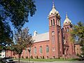
St. Michael's Church
-
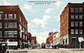
Downtown Grand Forks, around 1912
-
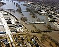
The Red River flooding in April 1997
-
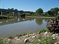
The meeting point of the Red and Red Lake Rivers
-
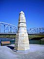
A memorial about the Red River flood
-
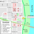
Map of downtown Grand Forks
-
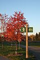
The Greater Grand Forks Greenway
-
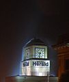
The clock tower of the Herald building in downtown Grand Forks
-
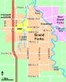
Map of Grand Forks, North Dakota
-
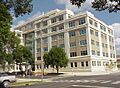
Grand Forks County Office Building
-
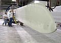
Employees at LM Glasfiber working on a blade for a wind turbine
See also
 In Spanish: Grand Forks para niños
