
River Tamar facts for kids
Quick facts for kids River Tamar |
|
|---|---|

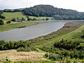
The Tamar near Bohetherick
|
|

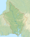
Map of the Tamar catchment
|
|
| Country | England |
| Region | Cornwall, Devon |
| Physical characteristics | |
| Main source | Woolley Moor, Morwenstow parish 50°55′25″N 4°27′44″W / 50.9235°N 4.4622°W, Cornwall 206 m (676 ft) |
| River mouth | Hamoaze Plymouth Sound, English Channel 50°21′30″N 4°10′0″W / 50.35833°N 4.16667°W |
| Length | 98 km (61 mi) |
| Discharge (location 2) |
|
| Basin features | |
| Tributaries | |
The Tamar (pronounced TAY-mar; in Cornish: Dowr Tamar) is a river in southwest England. It forms most of the natural border between Devon (to the east) and Cornwall (to the west). A large part of the Tamar Valley is a special place. It is recognized by UNESCO as a World Heritage Site because of its long history of mining.
The Tamar starts less than 6 km (3.7 mi) from the north Cornish coast. However, it flows south across the peninsula to the south coast. The river is about 98 kilometres (61 mi) long. At its end, the Tamar flows into the Hamoaze. This then leads into Plymouth Sound, which is a bay in the English Channel.
Many smaller rivers flow into the Tamar. On the Cornish side, these include the Inny, Ottery, Kensey, and Lynher. On the Devon side, the Deer and Tavy join the Tamar.
The name Tamar was first written down by Ptolemy in the 2nd century AD. Some people think the name means "great water." It might also come from an old word meaning "dark flowing," like the River Thames.
An old Roman record from the 7th century mentions a Roman town called Tamaris. We are not sure which town this refers to. Possible places include Plymouth, Launceston, or a Roman fort at Calstock.
Contents
What Makes the Tamar Valley Special?
The River Tamar and its surrounding land are very important for nature and history. They are protected in several ways. These include being a Site of Special Scientific Interest (SSSI) and a European Special Area of Conservation. The area is also known as an Area of Outstanding Natural Beauty. Part of it is even a UNESCO World Heritage Site. This is because of its historic mining past.
Tamar Valley: An Area of Outstanding Natural Beauty
The Tamar, Tavy, and Lynher rivers together form the Tamar Valley. This area is officially recognized as an Area of Outstanding Natural Beauty (AONB). The Tamar Valley AONB covers about 195 km2 (75 sq mi). It includes the lower part of the Tamar river, below Launceston, and its branches, the Tavy and Lynher.
This special status was first suggested in 1963. However, it was not officially named an AONB until 1995. The highest point in this beautiful area is Kit Hill, which is 334 meters above sea level. You can explore the valley by walking the Tamar Discovery Trail, a 35-mile hiking path that follows the river.
A Special Place for Nature: Special Area of Conservation

The Plymouth Sound and its estuaries are a Special Area of Conservation. This means they are very important for wildlife. It's unusual to find rocky reefs in low-salt water far inland on the Tamar. These reefs are home to special creatures like the hydroid Cordylophora caspia. The Tamar is one of the few estuaries where you can see different types of rocky habitats. These habitats change from the river's edge to deeper water, and along the river's path.
A Site of Special Scientific Interest
The Tamar–Tavy Estuary is a Site of Special Scientific Interest (SSSI). This area includes the tidal parts of the River Tamar and the River Tavy. Part of the Tamar estuary is also the Tamar Estuary Nature Reserve. This reserve is owned by the Cornwall Wildlife Trust.
The site was named an SSSI in 1991. It is important because it has many different types of plants and animals. It also has various habitats that support a large number of wader and wildfowl species. These are birds that live near water. The site is especially important for avocets in winter. It also supports birds like black-tailed godwits, Eurasian whimbrels, greenshanks, spotted redshanks, green sandpipers, and golden plovers.
UNESCO World Heritage Site: Mining History
For a very long time, people have used the Tamar Valley for its rich mineral deposits. These include silver, tin, lead, and arsenic. This history has left a unique landscape. It is a big part of the Cornwall and West Devon Mining Landscape. You can still see old engine houses and mines from the Bronze Age to modern times.
The export docks at Morwellham Quay were once a major international trading center. They shipped copper, lead, and arsenic around the world. In July 2006, the valley, along with the mining town of Tavistock, was added to the UNESCO World Heritage List.
How Healthy is the River Tamar's Water?
The Environment Agency checks the water quality of rivers in England. They give each river system an overall health rating. This rating can be high, good, moderate, poor, or bad. Many things help decide this rating. These include the types and numbers of invertebrates (small creatures without backbones), plants, and fish. They also check the chemical status, comparing chemical levels to safe amounts. This is rated as good or fail.
| Section | Ecological Status |
Chemical Status |
Overall Status |
Length | Catchment Area | Channel |
|---|---|---|---|---|---|---|
| Upper River Tamar | Moderate | Fail | Moderate | 13.417 km (8.337 mi) | 23.901 km2 (9.228 sq mi) | |
| Tamar (Small Brook to Lamberal Water) | Poor | Fail | Poor | 7.458 km (4.634 mi) | 14.966 km2 (5.778 sq mi) | |
| Tamar (River Ottery to River Deer) | Moderate | Fail | Moderate | 20.879 km (12.974 mi) | 48.056 km2 (18.555 sq mi) | |
| Tamar (River Ottery to River Lyd) | Moderate | Fail | Moderate | 5.318 km (3.304 mi) | 7.768 km2 (2.999 sq mi) | |
| Tamar (River Lyd to River Inny) | Moderate | Fail | Moderate | 8.829 km (5.486 mi) | 13.417 km2 (5.180 sq mi) | |
| Lower River Tamar | Moderate | Fail | Moderate | 38.087 km (23.666 mi) | 65.516 km2 (25.296 sq mi) | |
| Plymouth Tamar | Moderate | Fail | Moderate | Heavily modified |
River Tamar's Geography

Lakes and Reservoirs on the Tamar
The Upper Tamar Lake and Lower Tamar Lake are two small reservoirs found on the upper part of the Tamar river. The Lower Lake was built in the 1820s to supply water to the Bude Canal. Today, it is a nature reserve, a protected area for wildlife.
The Upper Lake was built later, in the 1970s. It provides fresh water to the Bude area. People also use it for fun activities like boating and fishing.
The Border Between Devon and Cornwall
The east bank of the Tamar river was set as the border of Cornwall by King Athelstan in the year 936. Over time, the border changed a few times. For example, some villages west of the Tamar were moved to Devon in the 11th century.
In 1966, the county border was put back to follow the Tamar river. Today, the modern border between Devon and Cornwall mostly follows the Tamar and the Hamoaze. There are only a few small places where the border does not follow the river. For example, parts of North Tamerton in Cornwall are east of the river.
Where the border follows the Tamar, it is usually in the very middle of the river. This is called the "centre of the river." However, near Saltash, the counties officially end at their own river banks when the tide is low.
How to Cross the River Tamar
List of crossings of the River Tamar

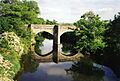
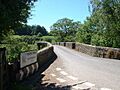
There are 22 road crossings over the Tamar river. Some of these are very old stone bridges from medieval times. The oldest bridge still standing is at Horsebridge, built in 1437. The next oldest is Greystone Bridge, built in 1439.
Gunnislake New Bridge was built in 1520. It was an important route into southeast Cornwall. It was also the lowest bridge over the Tamar until the Tamar Bridge opened in 1962. The Tamar Bridge is a modern road bridge near Saltash.
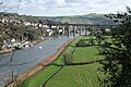
The lower part of the Tamar also has the Royal Albert Bridge. This is a railway bridge built in 1859. It is right next to the newer Tamar Bridge. Both of these bridges connect Saltash (which is called the 'Gateway to Cornwall') and Plymouth.
Further downstream, across the Hamoaze, you can find the Torpoint Ferry. This is a special chain ferry that connects Torpoint to Devonport. Even further down, there is the Cremyll Ferry.
The Calstock Viaduct is another impressive structure on the Tamar. It is 37 meters high and has twelve arches, each 18 meters wide. Three of its supports stand in the river. It was built between 1904 and 1907.
How People Use the River Tamar


The tidal part of the river is about 19.2 miles (30.9 km) long. This means boats can travel on it. The river's normal tidal limit is a small dam (weir) just below the village of Gunnislake. Boat traffic on the lower Tamar is managed by the Queen's Harbour Master for Plymouth.
The Royal Navy has one of its main naval bases at Devonport, located on the Hamoaze. Upstream from there, the river is mostly used by boats for fun. You can take boat trips on the river between Plymouth and Calstock from April to October.
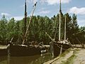
In the past, a typical boat on the Tamar was a sailing barge. These boats could be up to 60 tons. Large ships of up to 400 tons could sail as far inland as Weir Quay. Smaller boats could go even further, up to Weir Head, near Gunnislake.
The Tamar Manure Canal

In 1794, a company was formed to make the river easier to travel on. They wanted to extend the river's navigation inland for another 30 miles. An Act of Parliament in 1796 allowed them to do this. They planned to improve the Tamar from Morwellham Quay upstream and build a canal.
However, the project only went as far as Gunnislake. Work stopped in 1808. Barges of up to 30 tons could then go as far as Gunnislake New Bridge. They used a short, 500-yard canal to get around the weir. This short canal became known as the Tamar Manure Canal. It had one lock to help boats move between different water levels.
This navigation route was about 3.0 miles (4.8 km) long. It was used to bring in fertilizer (called "manure" back then) and coal. It also helped export bricks and granite. This short canal was profitable for many years. The Tamar Manure Navigation stopped working in 1929.
History of the River Tamar
In 997, according to old records, Viking raiders traveled up the Tamar and then the Tavy river. They went as far as Lydford and burned a monastery at Tavistock.
During the English Civil War, Cornwall supported King Charles I. Devon, however, supported Parliament. Because of this, the River Tamar became a place for many battles. Both sides knew that controlling the river crossings was very important.
In medieval times, goods were transported to supply the monastery at Tavistock. Sea sand was brought in for farms. Later, lime was found to be better for the soil. Large amounts of limestone and coal were imported to burn in limekilns along the river.
Later, things like street sweepings and bones were carried inland to fertilize fields. Other regular imports included timber from Canada and the Baltic region. This timber was used as pit props in the mines. Coal from Wales was also imported to power mine pumps.

Tavistock was one of the main towns for tin mining in Devon. A lot of refined tin ore was exported through Morwellham from the 12th century until 1838. The opening of the Tavistock Canal in 1817 made it easier to move goods. Later, the East Cornwall Mineral Railway also helped transport goods from the Cornish side of the valley.
Other important goods exported were granite, copper, lead, and manganese ores. Arsenic was also a valuable product. It was extracted from a mineral called mispickel. Arsenic was shipped worldwide, especially to the southern United States, where it was used to kill insects in cotton fields.
In the 13th century, lead and silver from the royal mines on the Bere peninsula were very important. Production continued off and on until the 19th century. A smelting factory at Weir Quay extracted silver and lead. They used local ore and also ore brought in by sea from Europe and even Newfoundland.

The old ferry crossings grew into busy river ports in the 18th and 19th centuries. The growth of Plymouth, Devonport, and Stonehouse at the mouth of the river created a big market for farm products from the valley. These products were always carried by boat.
In the early 1800s, the first paddle steamer on the Tamar started a service. It carried food from Calstock to Devonport. By 1859, a railway connected Plymouth to London. This meant fresh food could be shipped from Devonport in the evening and be sold in London the next morning.
Many people also enjoyed sightseeing cruises on the river. This was a popular activity from 1823 until World War II began.
Mineral traffic on the river decreased in the late 1800s. This happened after the railway reached Tavistock in 1859. Also, the copper and tin mines started to run out. The decline sped up from 1894 when the East Cornwall Mineral Railway was extended. Tourist and market traffic on the river remained strong until the war started in 1939.
Economy of the Tamar Valley

The rocks around Dartmoor contain many valuable minerals. These include tin, copper, tungsten, and lead. The medieval estate of Cotehele was a big producer of silver for the Royal Mint. During the Industrial Revolution, there was a lot of mining near the river.
The Tamar was important for shipping copper from ports like Morwellham Quay and Calstock to south Wales. There, the copper would be melted down. The valley is part of the Cornwall and West Devon Mining Landscape. The river has always been known for its excellent salmon. The valley was also famous for its early, high-quality soft fruits and market gardens. These were protected by the valley's steep slopes.
Fun Stories and Legends
The Devil and the Pasty
A traditional Cornish story says that the devil would never dare to cross the River Tamar into Cornwall. He was afraid he might end up as a pasty filling! People used to say the devil never came to Cornwall. One time, he reached Torpoint and saw that people ate many kinds of pies. He worried that "devilly pie" might be next, so he quickly went back to Devon. This funny legend is even part of a traditional Cornish folk song called Fish and Tin and Copper.
The Legend of Tamara
There is a legend about how the Tamar river got its name. It tells of a nymph named Tamara who lived in the underworld. Tamara wanted to explore the human world, even though her parents told her not to. One day, while wandering in Dartmoor, she met two giants named Tavy and Torridge. Both giants immediately fell in love with Tamara.
Tamara led the giants on a dance, always staying just out of their reach. Her father found her just as the giants finally caught her. He became very angry and cast a spell to make Tavy and Tawradge fall into a deep sleep. Tamara was furious and refused to go back to the underworld. Her father became even angrier and turned Tamara into a bubbling spring. This spring became the Tamar river, flowing all the way to the sea.
Tawradge woke up and was sad to find his beloved had become a river. He asked a magician for help. The magician turned him into a river too (the River Torridge and the River Taw). He hoped to find Tamara. However, Tawradge could never find her. Instead, he flowed north towards Bideford and the Bristol Channel. People say he still mourns his lost love, the Tamar. This legend explains why the River Torridge, which starts very close to the Tamar, flows away in a big arc. The other giant, Tavy, also woke up sad. His father, also a powerful magician, turned Tavy into a river. The Tavy searched for the Tamar and eventually found her. They merged into a wide and beautiful estuary.
Images for kids
-
The Tamar near Bohetherick
-
Map of the Tamar catchment
-
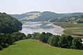
The tidal river, between Cotehele Quay and Weir Quay, with its mudbanks and reed beds.
-
The dam of the Upper Tamar Lake.
-
Higher New Bridge, near St Stephen by Launceston
-
Loading dock at Morwellham Quay; once an important industrial port, it featured an inclined plane which led up to the Tavistock Canal
-
High tide at Weir Head — excursion steamer Alexandra, 127 gross register tons, 126 feet in length, reversing at the entrance to the Tamar Manure Canal, in 1906.
-
The Horsebridge, built in 1437, is still used by motor traffic.
-
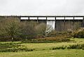
The Tamar Valley Line railway crosses the Tamar on a viaduct, built in 1907, at Calstock.
-
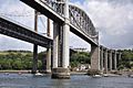
The Royal Albert Bridge and the Tamar Bridge at Saltash.
See also
 In Spanish: Río Tamar para niños
