
Tropical Storm Emily (2011) facts for kids
| Tropical Storm (SSHWS/NWS) | |

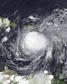
Tropical Storm Emily at peak intensity in the Caribbean Sea on August 3
|
|
| Formed | August 2, 2011 |
|---|---|
| Dissipated | August 11, 2011 |
| (Remnant low after August 7) | |
| Highest winds | 1-minute sustained: 50 mph (85 km/h) |
| Lowest pressure | 1003 mbar (hPa); 29.62 inHg |
| Fatalities | 4 direct, 1 indirect |
| Damage | $5 million (2011 USD) |
| Areas affected | Antilles, Florida, Bahamas |
| Part of the 2011 Atlantic hurricane season | |
Tropical Storm Emily was a weak tropical storm that brought a lot of rain to the northern Caribbean in 2011. It was the fifth named storm of the 2011 Atlantic hurricane season. Emily started from a large area of stormy weather called a tropical wave in late July.
On August 1, it moved closer to the Lesser Antilles and became more organized. This caused bad weather on many northern islands. By August 2, the storm's winds started to spin more like a cyclone, and it officially became Tropical Storm Emily.
Emily was not a very strong storm and its structure was often messy. However, it still caused strong thunderstorms and gusty winds as it moved across the Caribbean Sea. On August 4, Emily weakened after hitting the mountains of Hispaniola. Its winds became less organized.
Even after weakening, Emily's leftover parts briefly became a tropical storm again on August 6 before fading away completely the next day.
Despite its messy path, Emily caused severe weather in many Caribbean countries. Strong winds knocked down trees, and heavy rains led to widespread flooding in the Lesser Antilles. The worst damage happened in Martinique, where one person died.
In Puerto Rico, sudden floods affected homes and roads. This caused about US$5 million in damage to buildings and roads. Even after Emily was gone, its remnants continued to bring heavy rain to much of Hispaniola. Floods and mudslides in the Dominican Republic forced over 7,000 people to leave their homes. Three people drowned in the capital city of Santo Domingo.
In nearby Haiti, hundreds of houses in the Artibonite area were flooded. People living there had to leave. There was also some minor wind damage in the southern part of Haiti, and one person died in that area.
Contents
How Tropical Storm Emily Formed

Tropical Storm Emily's formation was a bit tricky and took several days. It started as a tropical wave that moved off the coast of West Africa in late July. A tropical wave is like a low-pressure area that travels across the ocean.
At first, this wave had a wide circulation with little rain. But over time, more and more thunderstorms started to gather around it. By July 30, it had two different centers of circulation. On July 31, the storm system became much more organized. The National Hurricane Center (NHC) thought it was close to becoming a tropical depression.
However, the main circulation then stretched out, and a part of it broke off. This new part briefly brought scattered thunderstorms to the Lesser Antilles. The next day, a new area of strong thunderstorms formed with a clearer center. As it passed through the Leeward Islands, its structure improved.
A special plane called a reconnaissance flight flew into the system. It found that the center of circulation was well-defined. So, at midnight UTC on August 2, the system was upgraded to a tropical storm and named Emily. It was located south of Dominica. At first, Emily moved quickly toward the west-northwest.

Experts thought Emily would only get a little stronger because the air around its path was quite dry. For several hours on August 2, the storm didn't change much. Later, it looked better on satellite images and developed a "ragged central dense overcast" (a messy area of strong thunderstorms). The NHC estimated that Emily reached its strongest winds of 50 mph (80 km/h) by midnight UTC on August 3.
However, the reconnaissance flights showed that Emily's circulation was still not very organized. Some forecasts even thought it would disappear before reaching Hispaniola. Strong winds high in the atmosphere pushed the deepest thunderstorms away from the center. This continued for the rest of the storm's life.
On August 4, the storm's clouds and rainbands became a bit more organized near its center. Emily then moved just south of the Dominican Republic. Here, its weak circulation was further broken up by the tall mountains and increasing wind shear (changes in wind speed or direction). The storm sped up over Hispaniola and turned into an open trough (a long area of low pressure) around 9 PM UTC that day.
Emily's Later Journey
The leftover trough from Emily moved northwest into the Bahamas. The NHC thought it had a good chance to reform because the wind shear was expected to decrease. Over the next two days, it moved over the Bahamas and then east of southern Florida.
Late on August 6, the trough developed a new center of circulation. It became a weak tropical depression again by 6 PM UTC near Grand Bahama. Emily briefly became a tropical storm again six hours later. But it quickly weakened back to a leftover low-pressure area the next day because of increasing wind shear.
The low-pressure area then moved quickly east-northeast, passing Bermuda before heading into the open Atlantic. It still had a wide area of strong winds and deep thunderstorms for a short time. However, strong wind shear and its fast speed stopped it from getting much stronger. The remnants of Emily finally disappeared around noon UTC on August 11. This was about 980 miles (1,565 km) west of the Azores.
Getting Ready for Emily
Because there was a high chance of a tropical storm forming, Météo-France issued yellow cyclone alerts for Guadeloupe and Martinique. They warned people about upcoming squally weather.
In Puerto Rico, a state of emergency was declared for the entire island. Officials prepared over 400 storm shelters and made sure there was enough water. The morning before the storm, government workers were sent home, and national courtrooms were closed. The United States Coast Guard told people in Puerto Rico and the U.S. Virgin Islands to avoid boating and swimming until Emily had passed.
JetBlue Airways allowed people to change their flights to the Dominican Republic without extra fees because of the bad weather. Four large cruise ships, including Oasis of the Seas and Freedom of the Seas, changed their routes in the Caribbean to avoid the storm.
In Haiti, about 630,000 people were still living in tents from the January 2010 earthquake. They didn't have strong homes to stay safe during a storm. This caused worries about how they would handle a tropical cyclone. Emergency officials in Haiti prepared 22 large buses to move thousands of people at risk of flooding. People were also told to save food and protect their belongings.
The United Nations had 11,500 troops in Haiti ready to help if needed. The International Federation of Red Cross and Red Crescent Societies also had emergency teams ready to deliver food. Before the storm, all airports and landing sites in Haiti were closed.
Emily's Impact
Impact in the Lesser Antilles
Heavy rainbands from Emily brought strong winds and up to 5.90 inches (150 mm) of rain to Martinique. This caused streets to flood and homes to be filled with water. About 5,000 homes lost power, but only for a short time. A large landslide happened in the capital city of Fort-de-France because the ground was too wet. About 40 families had to leave that area. In the city, floods affected 29 houses. One person died in a flooded home.
In Guadeloupe, the storm caused limited damage. Strong winds knocked down many trees and blew debris onto streets in Basse-Terre. One road was closed for safety but reopened soon after. Strong winds also knocked down some power lines in Saint Kitts and Nevis, causing two island-wide power outages. The storm brought some rain to the Virgin Islands, but totals were small, no more than 1 inch (25 mm). Winds were also light there, with the strongest gust being 52 mph (83 km/h) on Buck Island.
Impact in Puerto Rico

While moving slowly near Puerto Rico, Emily brought long periods of tropical storm conditions to many parts of the island. The heaviest rain fell in the southern areas. Caguas recorded 8.22 inches (209 mm) of rain during the storm. Strong winds damaged the electrical grid, leaving about 18,500 customers without power. Around 6,000 people also lost access to drinking water.
Dozens of people went to shelters, especially those living in areas at risk of flooding. Heavy rains, up to 10 inches (250 mm), caused three rivers to overflow. This led to the flooding and closing of the PR-31 highway and a part of the PRI-3 intersection. Many other roads across the island were blocked by landslides and fallen objects. Early estimates showed that damage to roads and buildings was over $5 million. The closing of businesses for two days affected about 280,000 workers. This caused an estimated $55 million in economic losses.
In San Lorenzo, 25 families were cut off when a bridge was at risk of collapsing. Flooded homes and messy streets were reported in Ceiba. In Yabucoa, heavy rains washed away 1,200 acres (490 ha) of banana plants.
Impact in Hispaniola
| Precipitation | Storm | Location | Ref. | ||
|---|---|---|---|---|---|
| Rank | mm | in | |||
| 1 | 1001.5 | 39.43 | Flora 1963 | Polo Barahona | |
| 2 | 905.0 | 35.63 | Noel 2007 | Angelina | |
| 3 | 598.0 | 23.54 | Cleo 1964 | Polo | |
| 4 | 528.0 | 20.79 | Emily 2011 | Neyba | |
| 5 | 505.2 | 19.89 | Jeanne 2004 | Isla Saona | |
| 6 | 479.8 | 18.89 | Inez 1966 | Polo | |
| 7 | 445.5 | 17.54 | Hurricane Four 1944 | Hondo Valle | |
| 8 | 391.4 | 15.41 | Hurricane Five 1935 | Barahona | |
| 9 | 359.9 | 14.17 | Hanna 2008 | Oveido | |
| 10 | 350.0 | 13.78 | T.S. One 1948 | Bayaguana | |
Even though Emily was disorganized, it and its remnants dropped a lot of rain across the Dominican Republic. Some areas, like Neiba, recorded up to 21 inches (528 mm) of rain. This caused severe flooding and mudslides, cutting off 56 communities from nearby areas. The storm forced 7,534 people to leave their homes across the country. Of these, 1,549 found safety in storm shelters.
Hours of continuous rain caused some rivers to overflow, but no major damage was reported nearby. Offshore, strong winds created rough waves that briefly affected boating and homes along the coast. East of Santo Domingo, two men drowned in a swollen river. Another person drowned in the capital due to flooding.
Because Emily weakened when it did, it saved Haiti from the severe damage that was first expected. At least 235 people in Jacmel and Tabarre, and 65 prisoners from Gonaïves and Miragoâne, had to be moved to safety during the storm. In Artibonite, civil protection teams moved about 300 residents.
Rainfall caused floods that damaged over 300 homes across Haiti. Several cholera treatment centers were also destroyed. To prevent new outbreaks, special cleaning supplies were given out to clean possibly contaminated water. One person died near Les Cayes, but the exact reason was unclear. Another person in the area was hurt by a fallen tree. Strong winds caused some property damage in Léogâne and Jacmel.
Impact Elsewhere
The leftover trough from Emily brought heavy rains to eastern Cuba. This caused some rivers to overflow. Flooding spread across roads in Santiago de Cuba, where 37 homes were affected by mud.
When Emily reformed into a tropical depression, it dropped a lot of rain in the Bahamas. A severe thunderstorm warning was issued for Grand Bahama and nearby waters. Rainfall totals of up to 7.9 inches (200 mm) were recorded there.
Images for kids
-
Tropical Storm Emily at peak intensity in the Caribbean Sea on August 3
See also
 In Spanish: Tormenta tropical Emily (2011) para niños
