
Uintah County, Utah facts for kids
Quick facts for kids
Uintah County
|
|
|---|---|
.jpg)
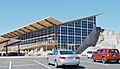
Quarry Visitor Center at Dinosaur National Monument.
|
|

Location within the U.S. state of Utah
|
|
 Utah's location within the U.S. |
|
| Country | |
| State | |
| Founded | February 18, 1880 |
| Named for | Ute Tribe |
| Seat | Vernal |
| Largest city | Vernal |
| Area | |
| • Total | 4,501 sq mi (11,660 km2) |
| • Land | 4,480 sq mi (11,600 km2) |
| • Water | 22 sq mi (60 km2) 0.5% |
| Population
(2020)
|
|
| • Total | 35,620 |
| • Estimate
(July 1, 2021)
|
36,204 |
| • Density | 7.9138/sq mi (3.0555/km2) |
| Time zone | UTC−7 (Mountain) |
| • Summer (DST) | UTC−6 (MDT) |
| Congressional district | 1st |
Uintah County is a county in the state of Utah. In 2020, about 35,620 people lived here. Its main city and county seat is Vernal. The county got its name from a part of the Ute Native American tribe. These people used to live in this area.
Uintah County is very important for energy. It produces the most natural gas in Utah. In 2008, it made 272 billion cubic feet of gas!
The Vernal area, which includes all of Uintah County, is considered a "Micropolitan Statistical Area." This means it's a city area with a population between 10,000 and 50,000 people.
Uintah County is also home to a campus of Utah State University in Vernal. It's a great starting point for visiting Dinosaur National Monument and the beautiful Uinta Mountains.
Contents
History of Uintah County
Early People and Explorers
Long ago, different groups of people lived in the Uinta Basin. These included ancient people from the Archaic period and the Fremont culture. When written history began, the Ute people were living here.
The first non-Native Americans to explore this area were Fathers Domínguez and Escalante in 1776. They were trying to find a land route from California to Spanish America.
Spanish and Mexican Control
The Spanish Empire claimed this region as part of New Spain. Later, from 1821 to 1848, Mexico controlled it. However, neither Spain nor Mexico had a strong presence here. Their control was mostly just on paper.
Fur Trappers and Mormon Settlers
In the early 1800s, some fur trappers came to the Basin. In 1831, a French trapper named Antoine Robidoux set up a trading post. It was near where Whiterocks is today. He left the area in 1844.
In 1847, a group of Mormons led by Brigham Young arrived west of Uintah County. They started what would become Salt Lake City. In 1861, Young sent a group to explore the Uinta Basin. They said the land was "valueless." So, Young did not try to build communities there.
United States Takes Over
The United States took control of the area in 1848 after the Treaty of Guadalupe Hidalgo. In 1861, President Abraham Lincoln created the Uintah and Ouray Indian Reservation. This land was set aside for the Ute and Colorado Native Americans. Later, in the 1880s, the Uncompahgre Reservation was created in the southern part of Uintah County.
Ashley Valley was not part of these reservations. By 1880, enough ranchers and farmers had moved there. So, the Utah government created Uintah County. It was made from parts of other counties like Sanpete and Wasatch. The first county seat was Ashley, a town that no longer exists.
County Changes and Discoveries
Uintah County's borders changed a few times. In 1918, the very northern part became Daggett County. This part was north of the Uinta Mountain watershed.
In 1888, a mineral called Gilsonite was found in Bonanza. This area was on Reservation land. Miners wanted to get to it, so the US government removed about 7,000 acres from the Reservation. This led to a quick boom in mining in the area.
Geography of Uintah County
Uintah County is on the east side of Utah. Its eastern border touches Colorado. The Green River flows through the middle of the county. It also forms part of the border with Duchesne County. Other rivers like the Duchesne River and the White River join the Green River here.
The land in the county slopes towards the south and west. The highest points are in the Uinta Mountains to the north. These mountains reach about 12,276 feet high. The county covers about 4,501 square miles in total. Most of this is land, with a small amount of water.
Uintah County is in the center of the Uintah Basin. This basin stretches from western Colorado to the Wasatch Mountains. It was formed by a huge ancient lake called "Uinta Lake."
The county has many different types of land. You can find high mountains, fertile valleys like Ashley Valley (where Vernal is), and rugged canyonlands. The famous Dinosaur National Monument is in these canyonlands. To the south, there are also desolate hills known as "The Bookcliffs."
Mines in Uintah County
- Dyer Mine (copper, gold, silver)
- Little Water Mine (coal)
- Uteland Mine (coal)
- Black Dragon Mine (Gilsonite)
Main Roads
- U.S. Route 40
- US Route 191
- Utah State Route 45
- Utah State Route 88
- Utah State Route 121
Neighboring Counties
- Daggett County - north
- Moffat County, Colorado - northeast
- Rio Blanco County, Colorado - east
- Garfield County, Colorado - southeast
- Grand County - south
- Emery County - southwest
- Carbon County - west
- Duchesne County - west
Protected Natural Areas
- Ashley National Forest (part)
- Dinosaur National Monument (part)
- Horseshoe Bend State Park
- Musket Shot Springs Scenic Overlook
- Ouray National Wildlife Refuge
- Point of Pines Recreation Site (part)
- Pot Creek Recreation Site
- Red Fleet State Park
- Sears Canyon Wildlife Management Area
- Steinaker State Park
- Stewart Lake Waterfowl Management Area
Lakes and Reservoirs
- Alma Taylor Lake
- Ashley Twin Lakes
- Association Reservoir
- Big Lake
- Billeys Reservoir
- Blue Lake
- Bottle Hollow Reservoir
- Box Reservoir
- Brough Reservoir
- Bullock Draw Reservoir
- Bullwinkle Reservoir
- Burns Bench Reservoir
- Burton Reservoir
- Butte Reservoir
- Cement Reservoir
- Chimney Rock Lake
- Chokecherry Flat Reservoir
- Counting Station Reservoir
- Cow Wash Reservoir
- Crouse Reservoir
- Dead Lake
- Deadman Lake
- Dollar Lake
- East Park Reservoir
- Fish Lake
- Flu Knoll Reservoir
- Goose Lakes
- Lower Goose Lake
- Upper Goose Lake
- Gull Lake
- Hacking Lake
- Hacking Reservoir
- Hatch Reservoir
- Herman-Sadlier Reservoir
- Hopper Lakes
- Johnson Lake
- Julius Park Reservoir
- Kibah Lakes
- Kilroy Reservoir
- Lake Wilde
- Lily Lake
- Lily Pad Lake
- Little Elk Lake
- Little Lake
- Long Park Reservoir
- Lower Grouse Reservoir
- Lynn Haslem Reservoir
- McCoy Reservoir Number 1
- McCoy Reservoir Number 2
- Matt Warner Reservoir
- Merkley Reservoir
- Mill Pond
- Moap Lake
- Montes Creek Reservoir
- Mytoge Lake
- Oaks Park Reservoir
- Paradise Park Reservoir
- Pariette East Dike Reservoir
- Pariette Flood Control Reservoir
- Paul Lake
- Pearl Lake
- Pelican Lake
- Red Belly Lake
- Red Fleet Reservoir
- Sand Lake
- Saucer Lake
- Shiner Reservoir
- Siddoways Reservoir
- Stauffer Chemical Tailings Pond North
- Steinaker Reservoir
- Stewart Lake
- Sunday School Reservoir
- Teds Lake
- Towave Reservoir
- Twin Lakes
- Warren Draw
- Watkins Lake (part)
- Whiterocks Lake
- Wooley Lakes
- Wooley Reservoir
- Workman Lake (part)
- Zelph Calder Reservoir
People of Uintah County
| Historical population | |||
|---|---|---|---|
| Census | Pop. | %± | |
| 1880 | 799 | — | |
| 1890 | 2,762 | 245.7% | |
| 1900 | 6,458 | 133.8% | |
| 1910 | 7,050 | 9.2% | |
| 1920 | 8,470 | 20.1% | |
| 1930 | 9,035 | 6.7% | |
| 1940 | 9,898 | 9.6% | |
| 1950 | 10,300 | 4.1% | |
| 1960 | 11,582 | 12.4% | |
| 1970 | 12,684 | 9.5% | |
| 1980 | 20,506 | 61.7% | |
| 1990 | 22,211 | 8.3% | |
| 2000 | 25,224 | 13.6% | |
| 2010 | 32,588 | 29.2% | |
| 2020 | 35,620 | 9.3% | |
| US Decennial Census 1790–1960 1900–1990 1990–2000 2010–2018 2020 |
|||
Population in 2020
In 2020, Uintah County had 35,620 people. This means there were about 7.9 people living in each square mile.
Most people in the county were White (about 80.6%). About 6.4% were Native American, and a small number were African American, Asian, or Pacific Islander. About 8% of the people were Hispanic or Latino.
There were slightly more females (50.35%) than males (49.65%). About one-third of the population (33.1%) was under 18 years old. The average age was 31.5 years.
There were nearly 12,000 households in Uintah County. Most of these (74.2%) were families. Many households (42.7%) had children under 18. About 71.9% of homes were owned by the people living in them.
Economy of Uintah County
The main way people make a living in Uintah County is by getting natural resources from the ground. This includes oil, natural gas, phosphate, and gilsonite.
There is also some agriculture here. Farmers mostly raise cattle and sheep. They also grow alfalfa, which is a plant used to feed animals.
A large part of western Uintah County is the Uintah and Ouray Indian Reservation. The Ute Tribe's main office is in Fort Duchesne. Much of the rest of the county is public land, like the Ashley National Forest. There isn't much private land in the county.
The discovery of many dinosaur bones and other ancient remains in the eastern part of the county created a lot of excitement. This led to the creation of Dinosaur National Monument. Besides the visitor center at the Monument, there's also a natural history museum in Vernal. It's called the Utah Field House of Natural History State Park Museum. It shows off some of the amazing finds from the area.
Getting Around Uintah County
Airport
The Vernal Regional Airport is in southeastern Vernal. You can fly from here to Denver, Colorado every day. The flights are operated by United Express.
Communities in Uintah County
Cities
Census-Designated Places (CDPs)
These are areas that are like towns but are not officially incorporated as cities.
Unincorporated Communities
These are small communities that are not part of any city or CDP.
Ghost Towns
These are towns that used to exist but are now abandoned.
- Dragon
- Rainbow
- Watson
- Bullionville
Education in Uintah County
Uintah County has one main school district, called the Uintah School District.
Sister City
Uintah County has a special connection with the Barkly Region in Australia. ![]() Barkly Region, Northern Territory, Australia
Barkly Region, Northern Territory, Australia
Images for kids
-
Quarry Visitor Center at Dinosaur National Monument.
See also
 In Spanish: Condado de Uintah para niños
