Vice-county facts for kids

A vice-county is a special way to divide the land in the British Isles. People also call them biological vice-counties because they are used for studying plants and animals. They help scientists collect data. Sometimes, they are called Watsonian vice-counties after Hewett Cottrell Watson. He first introduced them in 1852. Watson's vice-counties were based on old county lines in Britain. But he often split these areas into smaller, more even parts. He also made sure that small pieces of land (called exclaves) were part of the vice-county around them.
In 1901, a scientist named Robert Lloyd Praeger created a similar system for Ireland. This included its islands too.
Vice-counties are the main way to record where plants and animals are found. They give a steady way to record information using areas that are about the same size. Even though people now use National Grid maps more, vice-counties are still very helpful. Many local studies, like books about plants (called floras), use them. This makes it easy to compare information collected over many years. Vice-counties do not change when local government areas change. This helps compare old and new data accurately.
In 2002, the NBN Trust decided to make digital maps of the 112 vice-county borders. This was to celebrate 150 years of the Watsonian system. These maps were based on old paper maps from 1947. They were much more detailed than anything available before. The maps were shared for free. A final, official version was released in 2008. Before this, people only had two fold-out maps from 1969.
How the Vice-County System Started
The idea of vice-counties began with Hewett Cottrell Watson. He wrote about them in his book Cybele Britannica in 1852. He made the system even better in later books.
Watson's System for Britain
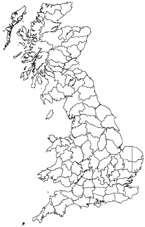
Watson's "Britain" included the island of Great Britain and all its nearby islands. This also included the Isle of Man. But it did not include the Channel Islands. He divided this area into 112 vice-counties. Larger counties were split up. For example, Devon was divided into North Devon and South Devon. Yorkshire was split into five vice-counties. Each of these 112 vice-counties has a name and a number. For example, Vice-county 38, or "VC38", is called "Warwickshire".
Praeger's System for Ireland
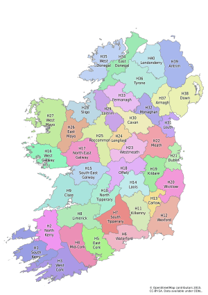
In 1901, Robert Lloyd Praeger added to the vice-county system for Ireland. This included its nearby islands. His system was based on an idea from C. C. Babington in 1859. The Irish vice-counties were based on the 32 old counties of Ireland. The six biggest counties were divided further. For example, County Cork was split into three vice-counties. This created 40 vice-counties for Ireland. They were numbered from H1 to H40 ("H" stands for "Hibernia"). Like the British vice-counties, each Irish vice-county has a name and a number. For example, Vice-county H3 is "West Cork".
Different Ways to Count Vice-Counties
When you combine the British and Irish systems, you get 152 vice-counties. Watson's system for Britain did not include the Channel Islands. This means different groups count the vice-counties in slightly different ways. The 152 vice-counties cover the "British Isles." This is how the 2008 Checklist of Beetles of the British Isles describes it.
However, some groups think the "British Isles" should include the Channel Islands. Since they are not part of the 152 vice-county system, the Channel Islands can be added. This makes 153 vice-counties in total. They might be shown with letters like "C" or "CI". Less often, each of the five Channel Islands is counted as its own vice-county. This would make 157 vice-counties in total.
The table below shows how the number of vice-counties can change.
| Count | Who Started It | What It Covers |
|---|---|---|
| 112 | Watson | Great Britain (including the Isle of Man) |
| 40 | Praeger | Ireland |
| 0, 1 or 5 | Channel Islands (Jersey, Guernsey, Alderney, Sark and Herm) | |
| 152, 153 or 157 | British Isles, Great Britain and Ireland |
The vice-counties of Britain alone are often called "Watsonian vice-counties". This term can also be used for the combined vice-counties of Britain and Ireland. These are also known as "Watson-Praeger vice-counties". In all these cases, the Channel Islands might be included or left out. This is why the total number of vice-counties can be different, as you saw in the table.
List of Vice-Counties
Vice-Counties in Southern England
|
Vice-Counties in Northern England and Wales
|
Vice-Counties in Scotland and the Isle of Man
|
Vice-Counties in Ireland
|
Irish Vice-Counties by Region
Praeger did most of his work before county borders changed in 1899. So, his vice-counties usually follow the older borders. Any differences from the pre-1899 borders are noted below.
| VC | Vice county | County | Province | Jurisdiction |
|---|---|---|---|---|
| H1 | South Kerry | Kerry | Munster | Republic of Ireland |
| H2 | North Kerry | Kerry | Munster | Republic of Ireland |
| H3 | West Cork | Cork | Munster | Republic of Ireland |
| H4 | Mid-Cork | Cork | Munster | Republic of Ireland |
| H5 | East Cork | Cork | Munster | Republic of Ireland |
| H6 | Waterford | Waterford | Munster | Republic of Ireland |
| H7 | South Tipperary | Tipperary | Munster | Republic of Ireland |
| H8 | Limerick | Limerick | Munster | Republic of Ireland |
| H9 | Clare | Clare | Munster | Republic of Ireland |
| H10 | North Tipperary | Tipperary | Munster | Republic of Ireland |
| H11 | Kilkenny | Kilkenny | Leinster | Republic of Ireland |
| H12 | Wexford | Wexford | Leinster | Republic of Ireland |
| H13 | Carlow | Carlow | Leinster | Republic of Ireland |
| H14 | Queen's County | Laois | Leinster | Republic of Ireland |
| H15 | South-east Galway | Galway | Connacht | Republic of Ireland |
| H16 | West Galway | Galway | Connacht | Republic of Ireland |
| H17 | North-east Galway | Galway | Connacht | Republic of Ireland |
| H18 | King's County | Offaly | Leinster | Republic of Ireland |
| H19 | Kildare | Kildare | Leinster | Republic of Ireland |
| H20 | Wicklow | Wicklow | Leinster | Republic of Ireland |
| H21 | Dublin | Dublin | Leinster | Republic of Ireland |
| H22 | Meath | Meath | Leinster | Republic of Ireland |
| H23 | Westmeath | Westmeath | Leinster | Republic of Ireland |
| H24 | Longford | Longford | Leinster | Republic of Ireland |
| H25 | Roscommon | Roscommon | Connacht | Republic of Ireland |
| H26 | East Mayo | Mayo | Connacht | Republic of Ireland |
| H27 | West Mayo | Mayo | Connacht | Republic of Ireland |
| H28 | Sligo | Sligo | Connacht | Republic of Ireland |
| H29 | Leitrim | Leitrim | Connacht | Republic of Ireland |
| H30 | Cavan | Cavan | Ulster | Republic of Ireland |
| H31 | Louth | Louth | Leinster | Republic of Ireland |
| H32 | Monaghan | Monaghan | Ulster | Republic of Ireland |
| H33 | Fermanagh | Fermanagh | Ulster | Northern Ireland |
| H34 | East Donegal | Donegal | Ulster | Republic of Ireland |
| H35 | West Donegal | Donegal | Ulster | Republic of Ireland |
| H36 | Tyrone | Tyrone | Ulster | Northern Ireland |
| H37 | Armagh | Armagh | Ulster | Northern Ireland |
| H38 | Down | Down | Ulster | Northern Ireland |
| H39 | Antrim | Antrim | Ulster | Northern Ireland |
| H40 | Londonderry | Londonderry | Ulster | Northern Ireland |
 | Shirley Ann Jackson |
 | Garett Morgan |
 | J. Ernest Wilkins Jr. |
 | Elijah McCoy |


