1936 Northeastern United States flood facts for kids
The 1936 Northeastern United States flood was a huge natural disaster that hit the Northeastern United States, the Mid-Atlantic region, and Ohio in March 1936. This historic flood happened after a winter with lots of snow and heavy rain in March. The combination caused rivers to overflow and led to major damage across a wide area.
Many rivers reached record-high levels. This included the Connecticut River, which rose to 37.6 feet in Hartford. Other rivers like the Merrimack River, the Pemigewasset River, and the Androscoggin River also saw record heights.
Sadly, the flood caused an estimated 150 to 200 deaths across the Northeast. It also resulted in hundreds of millions of dollars in damage, which was a huge amount of money back in 1936.
Contents
Why Did the Flood Happen?
The winter of 1935–36 was very cold, and the Northeast received more snowfall than usual. When March arrived, warmer temperatures caused this deep snow to melt quickly. This melting snow made river levels rise.
To make things worse, several big storm systems hit the region one after another in early to mid-March. The first storm started around March 9, bringing a lot of rain. Some areas in Northern New England reported as much as 5 inches of rain. A second, even stronger storm arrived around March 18. Pinkham Notch in New Hampshire recorded an amazing 10 inches of rain in just two days!
The United States Geological Survey (USGS) described March 1936 as a time with "one of the greatest concentrations of precipitation" ever recorded in the country. This means a huge amount of rain fell over a large area in a short time.
The First Flood Wave
Starting on March 12, areas from Maine to Pennsylvania began to experience flooding. A lot of damage was caused by ice jams on rivers, including the Hudson River. Ice jams happen when broken ice blocks a river, causing water to back up and overflow. By March 13, 20 people had died from this early flooding. A short freeze starting on March 13 helped slow down the flooding for a bit.
Massachusetts
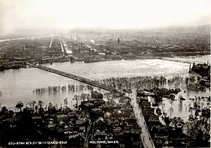
In Holyoke, Massachusetts, a 5,000 square foot section of the Holyoke Dam was ripped out by an ice jam.
Connecticut
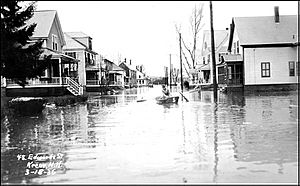
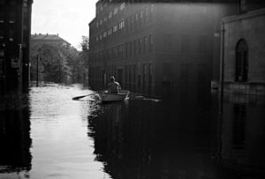
People called this the "worst Connecticut floods in years." It caused major damage to roads, railways, businesses, and homes. The New Haven Railroad and Central Vermont Railway reported many sections of their tracks washed away. Houses were carried away by the flooded Housatonic River. People living near rivers had to leave their homes. Some families were even rescued by rowboats!
The Second, Bigger Flood
After the March 18 storm, the flooding became much worse. It affected every state in the Northeast. It also spread to Virginia, Maryland, Delaware, Washington, D.C., West Virginia, and Ohio. Many rivers were full of ice, which made the damage even worse. In New England, especially in the northern states, ice jams and floating ice destroyed many bridges and damaged buildings. By March 19, over 200,000 people were left without homes. This number grew to 260,000 by March 21.
Maine
The Kennebec River experienced major flooding. Floating ice destroyed several bridges along the river. Damage along the Kennebec and Androscoggin Rivers was made worse by ice jams. Six bridges along the Saco River were also destroyed by the moving ice. In total, 81 highway bridges in Maine were destroyed or badly damaged.
New Hampshire
The Merrimack Valley had some of the worst flooding in New England. Hooksett, New Hampshire, was covered by water as deep as 20 feet. The dam of the Amoskeag Manufacturing Company in Manchester was saved by using over 500,000 sandbags. However, the company's buildings were still badly damaged. In New Hampshire, 87 towns reported some level of flood damage.
Massachusetts
The worst flooding in Massachusetts happened along the Connecticut River. By March 19, at least 15,000 people in Springfield had lost their homes. The United States National Guard was called in to help. They rescued people, stopped looting, and helped with rebuilding. The National Guard and the Springfield Police patrolled the city by boat because roads were underwater.
On the same day, a dam broke in Uxbridge. This sent a 15-foot-high wall of water down the Blackstone Valley. The Merrimack River reached a record 68.4 feet in Lowell. The Connecticut River reached a maximum depth of 49.2 feet in Montague. Both of these records still stand today.
Connecticut
Many towns along the Connecticut River faced the worst flooding ever. In Hartford, the river rose to 37.6 feet, a record that still stands. Twenty percent of downtown Hartford could only be traveled by boat. The city lost almost all power and phone service. Over 300 National Guardsmen were sent to patrol the flooded streets and rescue people.
In Middletown, the whole city stopped working after the power went out. The bridge to Portland was closed, leaving Middletown "virtually isolated."
Rhode Island
The Blackstone River rose very high in Rhode Island. There was major flooding in Woonsocket, where some streets became navigable only by boat. In Pawtucket, water rose almost as high as the city's bridges.
Pennsylvania
Pennsylvania experienced very damaging floods in Pittsburgh and Johnstown. In Johnstown, which had a famous flood in 1889, people worried about another dam breaking. Luckily, the dam held, but the city's rivers still overflowed. Much of Johnstown was covered in 12 to 14 feet of floodwaters. Transportation in Pittsburgh stopped because the city's train yards were flooded. By March 21, over 80,000 people in Pennsylvania had lost their homes.
West Virginia
Two bridges in Harpers Ferry were destroyed by the floodwaters. Another bridge in Shepherdstown was also destroyed. Lower Town Harpers Ferry was hit especially hard and was almost completely wiped out.
Maryland
Starting on March 17, Maryland was hit by severe flooding. The city of Cumberland, on the North Branch Potomac River, was badly damaged. The governor called in the Maryland National Guard to help. In Cumberland alone, the damage was estimated at over $50 million in today's money. The Potomac River reached 47.6 feet in Hancock. This broke the previous record from 1889 by 7.9 feet.
Virginia
The Potomac and James Rivers also had severe flooding in mid-March 1936. Great Falls experienced its highest floods ever recorded. Washington, D.C., saw its airport, Washington-Hoover Airport in Arlington, Virginia, flooded.
Washington, D.C.
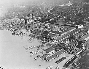
Flooding reached the nation's capital on March 20. The Potomac River rose to 18.5 feet under Key Bridge. This was the only bridge connecting D.C. to Virginia that stayed above the water. Large parts of the National Mall were flooded. However, there was enough warning for the Capitol Park Service to protect the Washington Monument and the Lincoln Memorial. They built a barrier of stone and sandbags with the help of over 3,000 men and many steam shovels. Hains Point was completely underwater, with only the tops of trees visible. Even with all this flooding, no one died in Washington, D.C.
Delaware
Delaware had only minor flooding, mostly affecting farmland. The Indian River Inlet Bridge was slightly damaged by ice in the Delaware River. Damage was also reported to the jetties in Bethany Beach.
What Changed After the Flood?
The huge amount of damage from the 1936 flood led to big changes in how the United States protected itself from floods. The Flood Control Act of 1936 was passed directly because of these floods. This law led to a lot of money being invested in flood protection. It funded the building of levees (raised banks), dams, reservoirs (large water storage areas), and other ways to prevent or lessen floods.
 | Misty Copeland |
 | Raven Wilkinson |
 | Debra Austin |
 | Aesha Ash |


