Clare, Suffolk facts for kids
Quick facts for kids Clare |
|
|---|---|
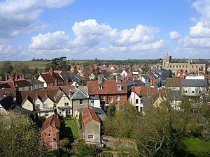 View over Clare from castle motte |
|
| Area | 9.26 km2 (3.58 sq mi) |
| Population | 2,028 (2011 Census) |
| • Density | 219/km2 (570/sq mi) |
| OS grid reference | TL770456 |
| Civil parish |
|
| District |
|
| Shire county | |
| Region | |
| Country | England |
| Sovereign state | United Kingdom |
| Post town | SUDBURY |
| Postcode district | CO10 |
| Dialling code | 01787 |
| Police | Suffolk |
| Fire | Suffolk |
| Ambulance | East of England |
| EU Parliament | East of England |
| UK Parliament |
|
Clare is a historic market town in Suffolk, England. It sits on the north bank of the River Stour. Clare is located in southwest Suffolk, about 14 miles (23 km) from Bury St Edmunds and 9 miles (14 km) from Sudbury.
In 2010, Clare was named "Village of the Year." It also won the "Anglia in Bloom" award in 2011 for its beautiful flower displays. In 2015, The Sunday Times and Zoopla listed Clare as one of the top 50 rural places in the UK. They noted its old buildings and rich history. In 2011, Clare had a population of 2,028 people.
People have lived in Clare and the area around it for thousands of years. This includes times before the Norman Conquest up to today. The town is home to Stour Valley Community School. This was one of the first free schools opened by the government in September 2011.
Contents
Clare's Landscape and Rivers
The land around Clare was formed during the Tertiary period. This means it has some of the newest rocks in the British Isles. Most of Suffolk's surface is made of fertile boulder clay or clay loam. This soil sits on top of layers of chalk. The landscape you see today was shaped by ancient glaciers and farming over many years.
Millions of years ago, this area was under the sea. Shells from sea creatures settled on the ocean floor and formed chalk. This happened about 140 million years ago. Another mineral, silica, filled sponges and other sea animals. When these were left behind, they formed hard pieces of flint.
A ridge of chalk from the ancient sea extends into Suffolk from Cambridgeshire. This chalk layer is the main "solid rock" underground. People used to dig up this chalk where it came to the surface. They would burn it to make lime for farming. Or, they mixed it with local sand to make mortar for building. This is why many old houses in the area are made of cream-colored bricks called 'Suffolk whites'.
During the Ice Age, the sea level was much lower. Melted ice from glaciers created deep valleys, including one under Clare. This valley was later filled with clay and gravel. The ice sheet also flattened the land, giving the area its current shape.
The main river in Clare Castle Country Park is not the River Stour. It's a mill stream called the 'new cut'. This stream was made in the 14th century to power a mill for the priory. It joins the Chilton stream at the east end of the park. The smaller River Stour flows south of the park, winding around the priory and meadows.
How Clare is Governed
Clare has been part of different local government areas over time. In 1894, it became part of the Clare Rural District. This district was then part of the larger West Suffolk county from 1889. In 1974, Clare joined the St Edmundsbury district. More recently, in 2019, Clare became part of the West Suffolk district.
Clare's Long History
Ancient Times
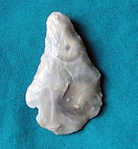
People have lived in Clare for a very long time. Tools from the Paleolithic (Old Stone Age) have been found in the Priory grounds. A stone macehead from the Mesolithic (Middle Stone Age) was found in the same spot. A Neolithic (New Stone Age) stone axe was pulled from the River Stour. Other flint tools and arrowheads from this period have also been discovered.
Evidence of ancient burial mounds (called barrows) from the Bronze Age has been found near Clare. These show that people lived and buried their dead here thousands of years ago.
An Iron Age pot and an iron spearhead were found in the river bank near Clare. These items are now kept in The Ancient House museum. Iron Age coins have also been found, including one from the Belgic Trinovantes tribe. In 2009, during work at Clare Community Primary School, signs of a late Bronze or early Iron Age building were found.
This supports the idea that Clare Camp is from that time. Clare Camp is a large ancient fort with double ditches, located at the north end of town. It covers about 2.9 hectares (7.2 acres). It is one of the most impressive forts of its kind in Suffolk. The camp was likely the first permanent settlement in the area.
Roman Times
Signs of Roman life have been found in Clare. These include a ditch, coins, and a small bronze statue. Some Roman bricks might even be in the Parish Church.
Larger Roman settlements were nearby, at Wixoe and Long Melford. At Wixoe, archaeologists found a small town that was lived in from about 100 to 400 AD. The Via Devana, a Roman military road from Chester to Colchester, passed through Wixoe. Another road led east from Wixoe, along the north side of the Stour.
Norman Times
The name 'Clare' first appeared in the Domesday Book in 1086. It was called 'Clara'. The name might come from the "clear" water of the Chilton Stream. The Domesday Book said Clare "Always a market. Now 43 burgesses". This was a very high number for the time.
The Domesday Book also mentioned meadows, woodlands, a mill, vineyards, and many sheep. The area around Clare belonged to a Saxon lord named Aluric. William the Conqueror later gave this land to Richard fitz Gilbert, one of his close supporters. Richard made Clare Castle the main center for his lands. He became known as "Richard de Clare." Clare Castle was first recorded in 1090.
The Lords of Clare
The de Clare family became very powerful. Richard's son, Gilbert de Clare, gave the church in the castle to the Benedictine Bec Abbey in Normandy. Later, in 1124, the Benedictines moved to Stoke-by-Clare.
In 1140, Richard's grandson, Gilbert de Clare, was given the title of Earl of Hertford by King Stephen. Later, Richard de Clare, 3rd Earl of Hertford and his son Gilbert were among the 25 barons who helped create the Magna Carta in 1215.
The wealthiest of the Clare family was Gilbert de Clare, 7th Earl of Gloucester, known as 'the Red'. He was a powerful figure in English history. He married Joan of Acre in 1290, who was the daughter of King Edward I. He owned land in 26 English counties and in Wales.
When Gilbert died in 1295, his wife Joan remarried. She started new work at Clare Priory. She was buried there in 1307. Her funeral was a big event, attended by royalty, including her brother King Edward II. It was said that her body was found to be perfectly preserved 52 years after her burial.
Gilbert's son, Gilbert, was the last male de Clare. He died in battle in 1314. One of his sisters, Elizabeth de Burgh, inherited the Clare property. She used her wealth to help found Clare College, Cambridge.
Later, the Clare estate passed to Elizabeth, who was Elizabeth de Burgh's granddaughter. Elizabeth married Lionel, the son of King Edward III. Lionel then became the Duke of Clarence. The famous poet Geoffrey Chaucer was once a page to Lionel.
After Elizabeth's death in 1360, Lionel married again. He died in Italy a few months later. His heart and bones were brought back to Clare to be buried next to his first wife. The title of Clarenceux King of Arms, an officer who deals with coats of arms, also comes from Clare or Clarence.
The estate eventually went to the Mortimers, the Earls of March. The castle began to fall apart around this time. The last descendant was Edward V, one of the two young Princes in the Tower. Later, Henry VII took over Clare. Henry VIII gave the lands to each of his wives. The lands of Clare were later transferred to the Duchy of Cornwall. This is why today William, Prince of Wales technically appoints the Vicar (church leader) in Clare.
Life in the Medieval Castle
At its busiest, during Elizabeth de Burgh's time, Clare Castle provided jobs for about 250 people. The castle's farm grew most of the food, including fruit from orchards. Inside the castle grounds, there were fishponds, a mill, a woodyard, a vineyard, and places for animals like dogs and swans. There were also workshops for making metal items, pottery, and jewelry. Elizabeth even had people who copied books by hand.
The castle had a main entrance, which is now gone. Only the name Nethergate (meaning 'Bottom Gate') remains. There were several towers, but their exact locations are unknown. The castle also had beautiful gardens with paths, fountains, and even a deer enclosure and a lion house. After Elizabeth's death in 1360, the castle was used less and less. By the 1480s, it was mostly abandoned.
The Black Death
In early 1349, the Black Death (a terrible plague) reached East Anglia. Records show many tenants died in March. However, the town's records do not show the same pattern. Life in the town seemed to continue as normal. Elizabeth de Burgh's castle records also do not mention the plague or any drop in daily activities. This suggests the town of Clare was not as badly affected as other places.
Guilds and Community Life
Local people in Clare formed groups called guilds. These were not for business, but for religious and community purposes. They helped the poor, prayed for members who had died, and supported the church and priory. There were five known guilds in Clare.
Guilds helped people prepare for the afterlife. By praying and doing good deeds in the guild's name, members hoped for a quicker journey through purgatory to heaven.
In the time of Henry VIII, England had many public holidays (holy days) each year. On these days, no one worked. The guild celebrating its feast day would have a procession and a church service. They would then provide entertainment, like mummers or miracle plays, and food for the poor. The Guild of St John even put out barrels of ale in five different streets for everyone to enjoy.
Clare had a guildhall (a meeting place for guilds) across from the church. It was probably shared by different guilds. This 14th-century building still stands today and is now a doctor's surgery.
However, all religious guilds were closed down by an Act of Parliament in 1547. Their properties and money were taken by the government. This act also stopped the worship of saints and masses for the dead. Public holidays and the entertainment and food provided by guilds also stopped. This period is known as the The Stripping of the Altars.
Wool Town
During the medieval period, Clare became a rich town because of cloth making. This trade grew steadily from the 13th century. In 1345, 3,000 local sheep fleeces were sold from Clare Manor alone. By the 1470s, Suffolk made more cloth than any other county.
The main product was broadcloth, a thick wool fabric. Water was very important for fulling (cleaning and thickening) the cloth. So, cloth production happened in towns along rivers like Clare. Many houses in Clare had cellars with water channels running through them for this purpose.
Merchants would travel in groups for safety to take their goods to Calais, which was then an English possession. One of the collection points in Suffolk was Callis Street in Clare.
Clothiers (people who organized the cloth industry) managed and paid for the work. They gave work to people across the town. They also helped maintain roads, gave money to the poor, and improved the priory and church. They built large houses for themselves.
In the 1540s, at the same time as the guilds were closed, new changes affected the cloth industry. The spinning wheel was introduced, and new fabrics from other countries became popular. This caused the production of broadcloth to decline. Clare did recover some of its industry in the late 16th century by making 'New Draperies'. These were lighter and cheaper cloths called 'bays and says'. By the 18th century, this industry also declined.
Into the Modern Age
After a good period in the 16th century, Clare slowly became less important as a leading town in West Suffolk. For a while in the 17th century, it was a key place for transport and distribution. It was on a main road to London. Inns and warehouses were important to the economy.
However, trade changed when the River Stour became navigable (boats could travel on it) as far as Sudbury in 1709. The handloom weaving industry disappeared by the 1800s. Straw-plaiting, a local home industry for making ladies' bonnets, also ended as fashions changed.
After a farming boom during the Napoleonic wars, farmers faced falling prices. Many workers lost their jobs. In 1816, people in Clare and nearby areas protested against new farm machines. Four local men were jailed for burning a threshing machine. This was during the "Year Without a Summer," caused by volcanic dust. There were floods, bad weather, and widespread unrest. Harvests were poor again in 1828 and 1829, leading to more protests. The Long Depression (1870–1895) caused many families to leave the town.
Old Travel Writings
William Camden wrote about Clare in his book Britain (1610). He said the River Stour ran by Clare, which was a "noble village" with a castle. He noted that the castle was "decayed" but gave its name to the noble Clare family.
Daniel Defoe in A tour thro' the Whole Island of Great Britain (1748) described Clare as "a poor town and dirty, the streets being unpaved." But he also said it had a good church and showed the ruins of a strong castle and an old monastery. He mentioned that Clare made 'says' (a type of cloth). Defoe also wrote about large groups of turkeys being taken from Clare to Colchester, sometimes 300 to 1,000 birds at once.
Discovering Clare's Past
As part of a project called "Managing a Masterpiece," people in Clare had the chance to dig small archaeological 'test pits' in 2011. This helped them learn how the town developed over thousands of years. Early findings showed Saxon pottery in many places. This was the first proof of Clare's importance before the Normans arrived. More digs in the castle grounds in 2013 found human remains. This suggested a cemetery was there before the castle was built.
Clare's Buildings and Architecture
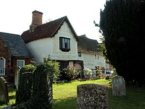
Clare has 133 listed buildings, which means they are historically important. More than 40 of these buildings are from the 16th century or even older. There are three Grade 1 listed religious buildings: the Priory, the Priory Chapel, and the parish church of Ss Peter and Paul.
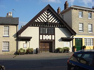
Three Grade 1 listed houses are Cliftons, Nethergate House, and the Ancient House. The Ancient House has beautiful decorative plasterwork called pargeting. It is partly a museum and partly a holiday home. A rare 13th-century well lined with flint was found behind a cafe. You can see many lovely timber-framed houses in Clare from the 14th to 16th centuries. There are also Georgian and Victorian houses. The center of Clare is a conservation area, meaning its historic character is protected.
Suffolk does not have much natural building stone. So, buildings are mostly made of timber (wood), usually oak beams with wattle and daub (a mix of woven sticks and clay) in between. Brickyards were common in Suffolk, and Clare had its own in the 19th century. Flint is also used for walls. When stone is found, it was usually brought from places like Barnack, near Peterborough.
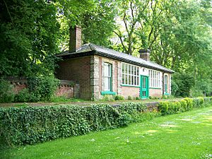
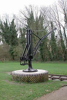
The 13th-century flint-stone castle keep sits on a 70-foot (21 m) high motte (a mound) overlooking the town. Parts of the castle's outer walls still exist. The castle is part of the Clare Castle Country Park. This park is special because it has the only old railway station in the UK built inside a castle. The station was built in 1865 and closed in 1967. The station buildings are listed as important historical structures. The park has 25 acres (10 ha) of landscaped land with water in the old moats. The Stour Valley Path crosses through the park.
A three-span cast iron bridge crosses the Stour on the way to Ashen. It was built in 1813 when Clare was on a main road between London and Bury St Edmunds. This bridge is Suffolk's oldest iron bridge still in use.
The tower of the wool church (St Peter and St Paul's church) was restored by the famous architect Detmar Blow. He also designed additions to Clare Priory.
Churches in Clare
Clare has four churches today:
- Clare Priory Chapel – This is the first home of the Augustinian Friars in England. It was founded in 1248. The friars helped local people with their spiritual and welfare needs. The priory was closed in 1538. Many of its buildings fell apart, and people used the stones for other constructions. The Augustinians bought it back in 1953. The old infirmary (hospital) building was restored to become a chapel. Today, it is a parish and retreat center. A Craft Fair is held there in July, attracting many visitors. The chapel has been extended with a new, modern church building. This new building won awards in 2015.
- St Peter and St Paul's Church, Clare – This is the Anglican church.
- The United Reformed Church – In 1645, a group of people who did not agree with the main church started their own services. As their numbers grew, they built a large meeting place in 1710. This was rebuilt in 1841 into the church you see today.
- Clare Baptist Church – In 1801, some independent groups formed a Baptist group. They built their first church in 1805. It was rebuilt in 1821 and then again in 1859 on High Street, where it stands today.
In the past, Quakers were also strong in the area and had their own meeting house by 1686. The oldest religious building still standing in Clare is the Norman chapel of St Mary Magdalene. It dates from about 1190. It was used as a chapel by the road. It later became a house and was even used to store gunpowder during the Civil War. Today, it is called Old Chapel.
Historic Pubs
Clare has four public houses (pubs), all in old buildings.
- The Swan on High Street is the oldest. One of its owners died from the Black Death in 1349. It has a very old carved oak sign above the door. This sign might be the oldest inn sign in England. It shows a chained swan, which was a symbol of Henry IV.
- The Bell on Market Hill was once a small alehouse. It was greatly changed around 1580 and became the Green Dragon. In the 1780s, it became a post house, where people could get fresh horses. It also sold goods and had its own brewery.
- The Cock in Callis Street might be from the 15th century. It was first called an inn in 1636. Parts of the building were once a barn, a schoolroom, and a butcher's shop.
- The Globe, near the Cock, dates from 1695. Its front was updated in the early 19th century with Suffolk white bricks. It probably opened as a pub in the 1880s.
Many other pubs and inns existed in the past, and most of their buildings are still standing today. The Nethergate Brewery started in Clare in 1986. It later moved to Pentlow and then to Sudbury.
Shops and Local Economy
Clare has many independent shops, most of them in Grade II listed historic buildings. These shops are mainly in the conservation area. The only chain store in town is the Co-operative Food supermarket. Clare's historic market is held on Market Hill on the third Saturday of each month.
Farming in Clare
The land around Clare is mostly used for growing crops. Farmers grow winter wheat, winter barley, sugar beet, oilseed rape, and broad beans for animal feed. Sugar beet is taken to the British Sugar factory in Bury St Edmunds.
In the Tudor period, the area was known for pastures and meadows. Farmers raised animals, kept bees, bred horses, and raised poultry. They grew barley, wheat, rye, oats, and other crops.
Because of the River Stour, there were mills in Clare. Four mills were reported in 1295. At least one mill was for fulling cloth. The last corn mill, Waymans Mill, was destroyed by fire in the late 1970s. Windmills also existed in the area.
The market in Market Hill, which had been there since before the Norman Conquest, became smaller after the railway arrived in 1865. Farmers preferred to take their produce to larger markets in Ipswich, Sudbury, or Cambridge. The Corn Exchange, built in 1838, eventually closed and was replaced by Clare Town Hall.
Farming and the landscape have changed a lot, especially in the last century. For example, Hull's Farm near Stoke-by-Clare used to have many small fields, hedges, and elm trees. It had 30 farm workers and many horses. To produce more food during and after World War II, a 40-acre wood was removed. Hedges were cut down. Then, Dutch elm disease killed many trees. Now, the farm buildings have been replaced by a nature reserve. The land is part of a larger farm with fewer workers and more machines. Crop production greatly increased between 1955 and 1996.
Local Issues
- Country Park
The Clare Castle Country Park is now owned by Clare Town Council. It is managed by a trust with the help of volunteers. The old station buildings have been restored. The stationmaster's house is now a home, and the main waiting room has been fixed up.
- Library
Suffolk County Council has created a new service to run libraries. A group called "Friends of Clare Library" has been formed to support it.
- Large Vehicle Problems
Clare is on the A1092 road. There are two sharp turns in the town, which makes it hard for large vehicles (HGVs) to get through. Buildings are often damaged. Several communities along the A1092 are asking for the road to be changed.
Town or Village?
In the time of the Domesday Book, Clare was one of only six places in Suffolk that had both markets and burgesses (important townspeople). Its manor was one of the largest in the county. The Lords of Clare made it their main administrative center. The castle itself provided jobs for many people. Clare was known as a borough by 1262.
From the 11th to the 16th century, Clare was a prosperous place with many jobs. The wool cloth trade did very well. It also became a key stop on a main road to London, with warehouses and inns. However, trade declined when the Stour became navigable to Sudbury in 1709. Weaving stopped, and Clare became a small farming center. Trade shrank even more when the railway arrived. The Parish Council was created in 1894.
Clare's population has usually been under 2,000 people. The number of houses has grown over time. Today, for a place of just over 2,000 people, Clare has a full range of services. These include a bank, butcher, doctors, library, shops, cafes, pubs, restaurants, antique shops, a pharmacy, hairdressers, and many other businesses and services. It also has a community woodland called "The Nuttery," which won an award for Best Conservation Project in 2011.
In modern terms, Clare is a large village. This is why it won "Suffolk Village of the Year 2010." However, the people of Clare still like to think of themselves as living in West Suffolk's smallest town. In April 2012, the parish council officially changed its name to a Town Council.
Notable People
- Elizabeth Mary Wells (1863–1922), a missionary and doctor, was born in Clare.
- Eric Barwell (1913–2007), a brave pilot in the Royal Air Force during World War II.
- Steve Harley (1951–2024), the lead singer of the glam rock band Cockney Rebel, lived in Clare for many years.
- Pamela Hansford Johnson (1952-1957), a writer, lived in Nethergate House.
- C P Snow (1952-1957), a writer and scientist, also lived in Nethergate House.
Population Information
According to the Office for National Statistics, Clare had a population of 2,028 people in 2011.
How Clare's Population Has Changed
| Population growth in Clare from 1801 to 1891 | ||||||||||
|---|---|---|---|---|---|---|---|---|---|---|
| Year | 1801 | 1811 | 1821 | 1831 | 1841 | 1851 | 1881 | 1891 | ||
| Population | 1,033 | 1,170 | 1,487 | 1,619 | 1,700 | 1,769 | 1,704 | 1,657 | ||
| Source: A Vision of Britain Through Time | ||||||||||
| Population growth in Clare from 1901 to 2011 | ||||||||||
|---|---|---|---|---|---|---|---|---|---|---|
| Year | 1901 | 1911 | 1921 | 1931 | 1951 | 1961 | 2011 | |||
| Population | 1,582 | 1,483 | 1,340 | 1,252 | 1,320 | 1,328 | 2,028 | |||
| Source: A Vision of Britain Through Time | ||||||||||
Location Grid
 |
Hundon | Chilton Street | Poslingford |  |
| Sturmer | Cavendish | |||
| Stoke-by-Clare | Ovington | Belchamp St Paul |
See also
 In Spanish: Clare (Suffolk) para niños
 | William Lucy |
 | Charles Hayes |
 | Cleveland Robinson |


