
Forest Park (Portland, Oregon) facts for kids
Quick facts for kids Forest Park |
|
|---|---|

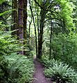
Wildwood Trail in June 2008
|
|

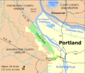
Location of Forest Park and Washington Park in Portland
|
|
| Location | Multnomah, Portland, Oregon, United States |
| Area | 5,172.14 acres (20.9309 km2) |
| Elevation | 718 ft (219 m) |
| Established | 1948 |
| Named for | Urban forest reserve |
| Governing body | Portland Parks & Recreation Department |
Forest Park is a large public park in Portland, Oregon, USA. It's located in the Tualatin Mountains, west of downtown Portland. This park stretches for over 8 miles (13 km) along hillsides. It overlooks the Willamette River.
Forest Park is one of the biggest urban forest reserves in the country. It's a key part of a larger system of parks and trails in the area. The park covers more than 5,100 acres (2,064 ha). Most of this is second-growth forest, meaning it has grown back after being logged. There are also a few parts with old growth trees.
About 70 miles (110 km) of trails wind through the park. These trails are great for hiking and exploring. One famous trail is the Wildwood Trail. It's part of Portland's 40-Mile Loop system.
People started wanting to create a natural park in the Portland woods way back in the 1860s. Their efforts led to a park commission being set up in 1899. In 1903, a famous landscape design company, the Olmsted Brothers, was hired. They created a plan for Portland's parks.
The city got land for the park in different ways. Some land was donated. Other parts came from Multnomah County or from unpaid taxes. In 1948, many pieces of land, totaling about 4,000 acres (1,600 ha), were combined. This created the Forest Park we know today. It is now the 19th largest park within U.S. cities.
Forest Park is home to many animals and plants. More than 112 kinds of birds live here. You can also find 62 different types of mammals. The park has a wide variety of trees and shade-loving plants. About 40 inches (1,000 mm) of rain falls on the forest each year.
Many small streams flow through the park. They flow northeast towards the Willamette River. One stream, Balch Creek, has trout. Another, Miller Creek, is home to salmon and other fish that travel from the sea.
Contents
Exploring Forest Park's Landscape
Forest Park sits on top of old, hardened lava. This lava is from the Columbia River Basalt Group. About 16 million years ago, huge lava flows covered a vast area. These flows created the base for the Tualatin Mountains, also called the West Hills. You can see these layered rocks along Balch Creek Canyon.
The West Hills are also covered by soft dirt that was blown there by the wind. This dirt can become unstable when it gets very wet. This means landslides can happen, which makes it hard to build houses in some higher areas.
Size and Location of Forest Park
Forest Park is about 8 miles (13 km) long. It's less than 1 mile (1.6 km) wide near downtown Portland. But it gets wider, about 2 miles (3.2 km) wide, at its far northwestern end. The park stretches along the West Hills. It goes from West Burnside Street near downtown Portland all the way to where the Willamette River splits around Sauvie Island.
The park covers most of the eastern side of the ridge above the Willamette River. Its edges are defined by West Burnside Street to the south. Northwest Skyline Boulevard is on the west. Northwest Newberry Road is to the north. And Northwest St. Helens Road (U.S. Route 30) is on the east. The park's elevation changes a lot. It's about 50 feet (15 m) above sea level near U.S. Route 30. It goes up to about 1,100 feet (340 m) near the top of the ridge.
In 2008, Forest Park was ranked as the 19th largest city park in the United States. This list included many types of parks, not just city-owned ones. Chugach State Park in Anchorage, Alaska, was the largest.
Marcy Houle, an author from Portland, describes the park beautifully. She says it "captures the essence of what is natural and wild and beautiful about the Northwest." From the park, you can see amazing views of Portland. You can also see the Willamette and Columbia rivers. On clear days, you might even spot five major peaks of the Cascade Range through the tall fir trees. Forest Park has always been a safe place for both people and wildlife.
History of Forest Park's Creation

Before settlers arrived, the land that is now Forest Park was covered in Douglas-fir trees. By 1851, settlers had claimed parts of this land. They planned to clear the forest and build homes. However, after logging, the steep slopes became unstable. Heavy rains caused landslides. This made building very difficult. So, many claims were given up or donated to the city.
Reverend Thomas Lamb Eliot, a minister who moved to Portland in 1867, was one of the first to push for a natural preserve. By 1899, his efforts led to the creation of the Municipal Park Commission of Portland. In 1903, this commission hired the famous Olmsted Brothers firm. They were asked to study the city's parks and suggest a plan.
John Charles Olmsted, the stepson of Frederick Law Olmsted, visited Portland in May 1903. The "Olmsted Report" was given in December. It suggested creating a system of parks and connecting parkways. These would use the natural beauty of the area. It proposed parks in places like Forest Park, Sellwood Park, and Mount Tabor Park.
How the Park Grew Over Time
The city slowly acquired land for Forest Park over many years. In 1897, Donald Macleay, a Portland merchant, gave 108-acre (44 ha) of land along Balch Creek to the city. This was meant to be an outdoor space for hospital patients. In the 1890s, Frederick Van Voorhies Holman, a Portland lawyer, offered 52 acres (21 ha) of nearby land. His siblings completed this donation in 1939.
Other companies and families also donated land. Clark and Wilson Timber Company gave 17 acres (6.9 ha) in 1927. The family of Aaron Meier, who started the Meier & Frank stores, donated land for Linnton Park. These smaller parks later became part of the larger Forest Park. Some, like Macleay Park, are still called by their original names.
The government also helped acquire land. In 1928, the City Council transferred land to the Parks Bureau for a wildflower garden. Multnomah County also gave the city use of about 145 acres (59 ha) of land. In 1945, the City Club of Portland studied the idea of Forest Park. This encouraged city leaders to support the project.
In 1948, Multnomah County transferred another 2,000 acres (810 ha) to the city. This land was acquired from unpaid taxes. On September 23, 1948, the city officially named 4,200 acres (17 km2) of land as Forest Park. By 2009, the park had grown to more than 5,100 acres (21 km2). It is one of the largest urban forest reserves in the U.S. The city's Parks and Recreation Department says it's the "largest forested natural area within city limits in the United States."
In 1991, Metro, the local government for the Portland area, started a program to protect natural areas. By 1995, they aimed to buy 320 acres (130 ha) next to or inside Forest Park. A bond measure in 2006 allowed for even more land to be bought. This helped expand the park and protect its streams. It also aimed to connect Forest Park to other public lands.
Fun and Recreation in Forest Park

Forest Park is a big part of a larger network of parks and trails in the region. This network is managed by Metro. At the park's southeastern end, you'll find the Wildwood Trail. This is the most important trail in Forest Park. It passes through Macleay Park. This area is very popular with people walking into Balch Creek Canyon.
Further southeast, the Wildwood Trail goes past Pittock Mansion. From here, you can see amazing views of Portland. You can also see five volcanoes: Mounts Rainier, Adams, St. Helens, Hood, and Jefferson. Beyond the mansion, the trail connects to Washington Park. You can reach places like the Oregon Zoo by crossing the Barbara Walker Crossing, a bridge over Burnside Street.
From here, and from other trailheads, you can connect to the 40-Mile Loop system. This system of trails goes around the city. It follows the Willamette and Columbia rivers. It also connects to other trails like the Springwater Corridor. This network links over 30 different parks. You can enjoy activities like horseback riding, inline skating, canoeing, and watching wildlife.
This network of parks and trails is still growing. Metro plans to connect the 40-Mile Loop to trails along the Willamette River. They also want to connect the Wildwood Trail to the Westside Trail. This trail runs north–south through Washington County. There are also plans for other trails to extend to the Sandy River Gorge Trail and even the Pacific Crest Trail.
The Wildwood Trail: A Park Highlight

Forest Park has over 70 miles (110 km) of trails and firelanes. The longest trail is the Wildwood Trail. About 27 miles (43 km) of it is in Forest Park. Another 3 miles (4.8 km) is in Washington Park. It's also the longest part of the 40-Mile Loop. This trail network is about 150 miles (240 km) long.
The Wildwood Trail runs from southeast to northwest. It starts at trail marker 0 in Washington Park. It ends near Northwest Newberry Road, just past trail marker 30. The trail is 30.2 miles (48.6 km) long because it has many twists and turns. In 2019, the city built the Barbara Walker Crossing. This bridge helps Wildwood Trail users cross West Burnside Street safely.
The Wildwood Trail starts near the Oregon Zoo. This area also has a light rail stop, the Oregon Vietnam Veterans Memorial, and the World Forestry Center. Blue diamond markers are placed on trees every 0.25 miles (0.40 km) along the trail. These markers and mileage numbers help hikers know where they are. In its first 5 miles (8.0 km), the trail passes by the Portland Japanese Garden, Pittock Mansion, and the Audubon Society of Portland wildlife sanctuary. It also goes near the Stone House in Balch Creek Canyon. After this point, the Wildwood Trail mostly goes through quiet forest.
Other Paths and Roads
Many shorter trails, roads, and firelanes cross the Wildwood Trail. Most trails are only for hikers and runners. But some roads and firelanes are open to bikes or horses. Leif Erickson Drive is a road closed to cars. It runs parallel to the Wildwood Trail for about 11 miles (18 km). It was renamed in 1933.
The park also has paths for oil, gas, and electric lines. Paved roads go around the park. Other roads like Northwest Pittock Drive and Northwest Cornell Road also cross or enter the park.
Plants and Trees of Forest Park

Forest Park is part of the Coast Range ecoregion. In its natural state, the forest mainly has three types of trees: Douglas-fir, western hemlock, and western red cedar. You can also find smaller numbers of grand fir, black cottonwood, red alder, bigleaf maple, madrone, and western yew. Most of the original forest was gone by 1940 due to logging and fires. The forest's current growth depends on when it was last logged or burned.
In the mid-1990s, some parts of the forest were cleared two to five years earlier. These areas had grasses, bracken, and fireweed. Other areas, about three to thirty years old, were in the shrub stage. They had small trees and plants like thimbleberry and salmonberry. Forests that were 10 to 30 years old had tall alder and maple trees. These made up about 20 percent of the park.
Larger areas of the park are covered by forests where conifers have grown taller than the alders and maples. These areas are between 30 and 80 years old. Douglas-firs are starting to become the main trees here. This type of forest makes up about 50 percent of Forest Park.
About 25 percent of the park has older conifer forests, 80 to 250 years old. In these areas, red alders, which live for about 100 years, start to die. The Douglas-firs, which can live for 750 years, grow very tall, up to about 240 feet (73 m). Under these big trees, you'll find shade-loving trees like western red cedar and western hemlock. Smaller plants like Oregon-grape and salal also grow there.
The oldest forest stage is called old growth. This stage is reached after 250 years. It includes many dead standing trees (snags) and fallen logs. By 1940, logging and fires had removed almost all old growth in Forest Park. So, most of the forest is not yet at this stage. Some small patches of old growth exist near Macleay Park and further west.
The largest tree in Forest Park is a Douglas-fir. It's near the Stone House, which used to be a public restroom near Balch Creek. This tree is 242 feet (74 m) high. Its trunk is 18.6 feet (5.7 m) around.
You can also find beautiful wildflowers in the park. These include Hooker's fairy bells, vanilla leaf, and trillium. However, some plants that are not native to the area, like English ivy and Himalayan blackberry, are also growing there. Groups like the No Ivy League and The Forest Park Conservancy work to remove these invasive plants. They also help maintain trails and plant native species.
Animals and Wildlife in Forest Park

The wildlife in Forest Park is connected to other natural areas nearby. This allows birds and animals to move between the park and places like the Tualatin River valley and the Oregon Coast Range.
Sixty-two different kinds of mammals live in Forest Park. These include the northern flying squirrel, black-tailed deer, bobcat, coyote, and Roosevelt elk. More than 112 types of birds have been seen in the park. Some of these are the blue grouse, great horned owl, hairy woodpecker, and osprey.
Next to Forest Park, in Balch Creek Canyon, the Audubon Society of Portland has a wildlife sanctuary. It has over 4 miles (6.4 km) of trails. It also has a wildlife care center and bird exhibits. You can find amphibians like rough-skinned newts and Pacific tree frogs in the Audubon Society pond.
Sadly, some animals like wolves and bears are no longer found here. This is due to habitat loss and urban growth. However, smaller animals like weasels and raccoons are more common. Invasive plants like English ivy can make the habitat less suitable for native insects and amphibians. Roads also make it hard for large animals to move around. Also, dogs running off-leash can be a threat to birds and other wildlife.
Streams and Waterways
About 40 inches (1,000 mm) of rain falls on Forest Park each year. Many small streams flow through the park. They flow from the top of the West Hills down to the base, near U.S. Route 30. Only a few of these streams have names. The five named streams, from east to west, are Balch Creek, Rocking Chair Creek, Saltzman Creek, Doane Creek, and Miller Creek. Rocking Chair Creek flows into Saltzman Creek.
After leaving the park, these streams flow through pipes and tunnels before reaching the Willamette River. These pipes usually block fish from swimming to and from the Willamette River. However, on Miller Creek, the pipes are short and have been changed to help fish pass through.
Near the east end of the park, Balch Creek has a population of cutthroat trout. Near the west end, Miller Creek is more natural. It has a greater variety of water creatures than other streams in Forest Park. Surveys of Miller Creek in 1990 found sea-run cutthroat trout and coho salmon. They also found many macroinvertebrates. These included stoneflies, mayflies, caddisflies, and crayfish.
Images for kids
-
Wildwood Trail in June 2008
-
Location of Forest Park and Washington Park in Portland
-
A bridge in then Macleay Park circa 1914
-
Forest Park trillium in multiple growth stages
-
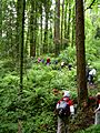
Volunteers at work on Wildwood Trail
-
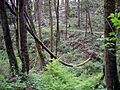
A fallen alder assumes a bow shape near Wildwood Trail.
-
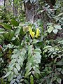
Oregon-grape at the foot of a Douglas-fir near Wildwood Trail
-
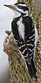
The hairy woodpecker is one of many species of birds living in the park.

See also
 In Spanish: Forest Park (Portland) para niños
