
Geography of Honduras facts for kids
 |
|
| Continent | North America |
|---|---|
| Region | Central America |
| Coordinates | 15°00′N 86°30′W / 15.000°N 86.500°W |
| Area | Ranked 101st |
| • Total | 112,492 km2 (43,433 sq mi) |
| • Land | 99.82% |
| • Water | 0.18% |
| Coastline | 832 km (517 mi) |
| Borders | none |
| Highest point | Cerro Las Minas 2,870 metres (9,420 ft) |
| Lowest point | Caribbean Sea 0 metres (0 ft) |
| Longest river | Ulúa 400 km (250 mi) |
| Largest lake | Lake Yojoa 79 km2 (31 sq mi) |
| Exclusive economic zone | 249,542 km2 (96,349 sq mi) |

Honduras is a country located in Central America. It has coastlines on both the Caribbean Sea and the North Pacific Ocean. To its west is Guatemala, to its southeast is Nicaragua, and to its southwest is El Salvador. Honduras is the second largest country in Central America. Its total area is about 112,890 square kilometers.
Honduras has a long Caribbean coastline, stretching about 700 kilometers. This coast runs from the Río Motagua in the west to the Río Coco in the east. The border with Nicaragua is about 922 kilometers long. It follows the Río Coco and then goes southwest through mountains to the Gulf of Fonseca. The southern part of Honduras has a 153-kilometer coastline on the Gulf of Fonseca, which leads to the Pacific Ocean. To the west, Honduras shares a 342-kilometer border with El Salvador. It also has a 256-kilometer border with Guatemala.
Contents
- Exploring the Land: What Does Honduras Look Like?
- Honduras's Climate: What's the Weather Like?
- Rivers and Lakes: Honduras's Waterways
- Honduras at a Glance: Key Facts and Figures
- Natural Riches: What Resources Does Honduras Have?
- Natural Dangers: What Hazards Does Honduras Face?
- Environmental Challenges: Protecting Honduras's Nature
- Images for kids
- See also
Exploring the Land: What Does Honduras Look Like?

Honduras has three main types of land. There is a large area of highlands in the middle. There are also two narrow coastal lowlands. One is along the Caribbean Sea, and the other is by the Pacific Ocean. The central highlands make up about 80 percent of the country. The coastal lowlands are flat areas made of river soil.
The High Mountains of Honduras
The central highlands are the most important part of Honduras's land. This mountain area covers about 80% of the country. Most people in Honduras live here. It has been hard to build roads and farms in this rugged area. The soil is not very rich. Honduras does not have the fertile volcanic ash found in some other Central American countries. For a long time, the main jobs here were mining and raising animals.
In western Honduras, the mountains connect with those in Guatemala. The highest peaks are in the western mountains. Pico Congolón is about 2,500 meters high. Cerro Las Minas is about 2,850 meters high. The border with El Salvador crosses Cerro El Pital. This is the highest point in El Salvador, over 2,730 meters tall. These mountains are covered with pine forests.
In eastern Honduras, the mountains join those in Nicaragua. These eastern mountains are usually not as high as the western ones. But they still have some tall peaks. Examples include Montaña de la Flor (2,300 meters), El Boquerón (2,485 meters), and Pepe Bonito (2,435 meters).
A special feature of the highlands is a long valley. It stretches from the Caribbean Sea to the Gulf of Fonseca. This valley divides the country's mountain ranges into eastern and western parts. It also makes it easier to travel across Honduras. The valley is widest near San Pedro Sula in the north. It gets narrower as it follows the Río Humuya. It passes through Comayagua and then widens again near the border with El Salvador.


Many flat valleys are scattered throughout the highlands. They are between 300 and 900 meters high. The floors of the larger valleys have enough grass and trees for raising animals. Some areas are used for farming. Small farms are often on the slopes of the valleys. These farms often use old methods and produce less food. Towns and cities, like the capital Tegucigalpa, are found in the larger valleys.
The plants in the highlands are diverse. Much of the western, southern, and central mountains have open woodlands. These have pine forests mixed with oak trees, bushes, and grassy areas. The eastern mountains have thick, broad-leaf evergreen forests. Around the highest peaks, you can still find parts of the dense rainforest that once covered much of the area.
The Caribbean Coast: Honduras's Northern Lowlands
This area has river valleys and flat coastal plains. Many Hondurans call it "the north coast" or just "the coast." This region has been very important for Honduras's economy. The central part of the Caribbean lowlands, east of La Ceiba, is a narrow plain. It is only a few kilometers wide.
To the east and west, the Caribbean lowlands get wider. They stretch far inland along wide river valleys. The widest river valley is along the Río Ulúa, near the Guatemalan border. This is the most developed area in Honduras. Puerto Cortés, the country's largest port, is here. San Pedro Sula, Honduras's industrial center, is also here. La Ceiba, the third largest city, is located in this region too.
To the east, near Nicaragua, the Caribbean lowlands become a large area called La Mosquitia. Unlike the western part of the Caribbean lowlands, Mosquitia is the least developed area in Honduras. It has few people and a different culture from the rest of the country. The area has grassy plains inland. Near the coast, there are swamps and mangrove forests. When it rains a lot, much of the grassy area is covered by shallow water. This makes travel very difficult without a special boat.
The Pacific Coast: Southern Lowlands
The Pacific lowlands are the smallest land region in Honduras. It is a strip of land about 25 kilometers wide. It is on the north shore of the Gulf of Fonseca. The land is flat and becomes swampy near the gulf. It is mostly made of rich soil washed down from the mountains. The gulf is shallow and has many fish and mollusks. Mangrove trees grow along the shore. Their underwater roots create safe places for shrimp and shellfish to breed. This makes them very common here.
Several islands in the gulf belong to Honduras. The two largest are Zacate Grande and El Tigre. They are old volcanoes. These islands are part of a chain of volcanoes along Central America's Pacific coast. Both islands have volcanic peaks over 700 meters high. They serve as important landmarks for ships entering Honduras's Pacific waters.
Honduras's Islands
Honduras controls several islands off its coasts. In the Caribbean Sea, the islands of Roatán, Utila, and Guanaja form the Islas de la Bahía (Bay Islands). This is one of the 18 departments of Honduras. Roatán, the biggest island, is about 50 kilometers long and 5 kilometers wide. The Bay Islands also include smaller islands like Barbareta, Santa Elena, and Morat.
Further out in the Caribbean are the Islas Santanillas, also known as Swan Islands. There are also small islands and keys nearby, such as Cayos Zapotillos and Cayos Cochinos. In the Gulf of Fonseca, the main islands controlled by Honduras are El Tigre, Zacate Grande, and Exposición.
Honduras's Climate: What's the Weather Like?

Honduras has a tropical climate. The highlands have a temperate climate.
The climate is different in each of the three main land regions. The Caribbean lowlands have a tropical wet climate. This means high temperatures and humidity all year. Rain falls fairly evenly throughout the year. The Pacific lowlands have a tropical wet and dry climate. Temperatures are high, but there is a clear dry season from November to April. The interior highlands also have a dry season. However, temperatures here get cooler as you go higher up.
In tropical areas, temperatures change mostly with how high you are, not with the seasons. Land below 1,000 meters is called tierra caliente (hot land). Between 1,000 and 2,000 meters is tierra templada (temperate land). Above 2,000 meters is tierra fría (cold land). Both the Caribbean and Pacific lowlands are tierra caliente. Daytime temperatures average between 28 and 32°C all year.
In the Pacific lowlands, April is the warmest month. This is the end of the dry season. The rainy season is a bit cooler. But higher humidity during the rainy season can make it feel more uncomfortable. In the Caribbean lowlands, the only break from the heat and humidity comes in December or January. Sometimes, a strong cold front from the north brings cooler temperatures and strong winds for a few days.
The interior highlands range from tierra templada to tierra fría. Tegucigalpa is in a sheltered valley, about 1,000 meters high. It has a pleasant climate. The average high temperature is 30°C in April (the warmest month). It drops to 25°C in January (the coolest month). Above 2,000 meters, temperatures can drop to near freezing at night. Frost can sometimes happen.
Rain falls all year in the Caribbean lowlands. But it is seasonal in the rest of the country. Rainfall is very heavy along the north coast. Especially in Mosquitia, where the average rainfall is 2,400 mm. Near San Pedro Sula, there is slightly less rain from November to April. But each month still gets a lot of rain. The interior highlands and Pacific lowlands have a dry season. This is called "summer" from November to April. Almost all the rain in these areas falls during "winter," from May to September. The total yearly rainfall depends on the surrounding land. Tegucigalpa, in a sheltered valley, gets only about 1,000 mm of rain.
Hurricanes and Tropical Storms
Honduras is in the path of hurricanes. The Caribbean coast is especially at risk from hurricanes or tropical storms. Hurricane Francelia in 1969 and Tropical Storm Alleta in 1982 affected many people. They caused a lot of damage to crops. Hurricane Fifi in 1974 killed over 8,000 people. It also destroyed almost all the banana crops.
In 1998, Hurricane Mitch became one of the deadliest hurricanes in the Western Hemisphere in 200 years. This huge hurricane hit the Honduran coast. It also covered almost the entire country with strong winds and heavy rain. About 100,000 Hondurans had to leave the Caribbean coast. Most of the Bay Islands had damage to their water systems.

The heavy rainfall caused many rivers to overflow. The United Nations said this was "to an unprecedented extent this century." Two earthflows caused major damage near Tegucigalpa. Hurricane Mitch caused huge damage across Honduras. It affected almost everyone and damaged all 18 departments. The United Nations estimated that Mitch caused the worst floods of the 20th century in the country. Across Central America, Mitch killed over 11,000 people. Thousands more went missing.
Hurricanes sometimes form over the Pacific Ocean. They can move north and affect southern Honduras. But Pacific storms are usually less severe and hit land less often.
On September 4, 2007, Hurricane Felix hit Honduras and Nicaragua. It was a very strong Category 5 hurricane. In November 2008, Hurricane Paloma and the October 2008 Central America floods caused at least 60 deaths. More than 300,000 people needed help.
Drought and Its Effects
Drought in Honduras has caused many people to leave the country. It leads to poor harvests for small farmers. Drought has also been a reason for migrant caravans heading to the United States.
According to the FAO, people leaving central and western Honduras between 2014 and 2016 often said "no food" was why they left.
Examples of Climate Data
| Climate data for Tegucigalpa (Tegucigalpa Airport) 1961–1990, extremes 1951–present | |||||||||||||
|---|---|---|---|---|---|---|---|---|---|---|---|---|---|
| Month | Jan | Feb | Mar | Apr | May | Jun | Jul | Aug | Sep | Oct | Nov | Dec | Year |
| Record high °C (°F) | 33.0 (91.4) |
34.5 (94.1) |
35.5 (95.9) |
36.6 (97.9) |
36.9 (98.4) |
34.5 (94.1) |
35.9 (96.6) |
36.9 (98.4) |
34.2 (93.6) |
34.8 (94.6) |
32.8 (91.0) |
31.4 (88.5) |
36.9 (98.4) |
| Mean daily maximum °C (°F) | 25.7 (78.3) |
27.4 (81.3) |
29.5 (85.1) |
30.2 (86.4) |
30.2 (86.4) |
28.6 (83.5) |
27.8 (82.0) |
28.5 (83.3) |
28.5 (83.3) |
27.3 (81.1) |
26.0 (78.8) |
25.4 (77.7) |
27.9 (82.2) |
| Daily mean °C (°F) | 19.5 (67.1) |
20.4 (68.7) |
22.1 (71.8) |
23.4 (74.1) |
23.6 (74.5) |
22.6 (72.7) |
22.1 (71.8) |
22.4 (72.3) |
22.2 (72.0) |
21.5 (70.7) |
20.4 (68.7) |
19.7 (67.5) |
21.7 (71.1) |
| Mean daily minimum °C (°F) | 14.3 (57.7) |
14.5 (58.1) |
15.5 (59.9) |
17.1 (62.8) |
18.2 (64.8) |
18.2 (64.8) |
18.0 (64.4) |
18.0 (64.4) |
17.9 (64.2) |
17.6 (63.7) |
16.3 (61.3) |
15.0 (59.0) |
16.7 (62.1) |
| Record low °C (°F) | 4.5 (40.1) |
7.2 (45.0) |
4.7 (40.5) |
8.9 (48.0) |
11.1 (52.0) |
12.4 (54.3) |
12.6 (54.7) |
12.2 (54.0) |
11.0 (51.8) |
10.0 (50.0) |
7.7 (45.9) |
6.8 (44.2) |
4.5 (40.1) |
| Average precipitation mm (inches) | 5.3 (0.21) |
4.7 (0.19) |
9.9 (0.39) |
42.9 (1.69) |
143.5 (5.65) |
158.7 (6.25) |
82.3 (3.24) |
88.5 (3.48) |
177.2 (6.98) |
108.9 (4.29) |
39.9 (1.57) |
9.9 (0.39) |
871.7 (34.32) |
| Average precipitation days (≥ 1.0 mm) | 1 | 1 | 1 | 2 | 9 | 12 | 9 | 9 | 13 | 10 | 4 | 2 | 73 |
| Average relative humidity (%) | 71 | 66 | 62 | 60 | 67 | 75 | 74 | 73 | 76 | 78 | 77 | 75 | 71 |
| Mean monthly sunshine hours | 220.8 | 229.4 | 268.5 | 242.8 | 216.3 | 171.7 | 192.5 | 204.8 | 183.4 | 200.4 | 199.2 | 212.2 | 2,542 |
| Source 1: NOAA | |||||||||||||
| Source 2: Deutscher Wetterdienst (humidity, 1951–1993) Meteo Climat (record highs and lows) | |||||||||||||
| Climate data for San Pedro Sula (La Mesa International Airport) 1961–1990, extremes 1944–present | |||||||||||||
|---|---|---|---|---|---|---|---|---|---|---|---|---|---|
| Month | Jan | Feb | Mar | Apr | May | Jun | Jul | Aug | Sep | Oct | Nov | Dec | Year |
| Record high °C (°F) | 37.2 (99.0) |
39.5 (103.1) |
42.8 (109.0) |
42.0 (107.6) |
42.0 (107.6) |
41.1 (106.0) |
38.0 (100.4) |
38.8 (101.8) |
39.2 (102.6) |
37.8 (100.0) |
37.5 (99.5) |
37.0 (98.6) |
42.8 (109.0) |
| Mean daily maximum °C (°F) | 29.2 (84.6) |
30.4 (86.7) |
33.0 (91.4) |
34.0 (93.2) |
35.2 (95.4) |
34.3 (93.7) |
33.3 (91.9) |
33.4 (92.1) |
33.5 (92.3) |
31.6 (88.9) |
30.2 (86.4) |
29.2 (84.6) |
32.3 (90.1) |
| Daily mean °C (°F) | 23.5 (74.3) |
24.1 (75.4) |
25.8 (78.4) |
27.1 (80.8) |
28.1 (82.6) |
27.7 (81.9) |
27.1 (80.8) |
27.3 (81.1) |
27.2 (81.0) |
26.0 (78.8) |
24.7 (76.5) |
23.7 (74.7) |
26.0 (78.8) |
| Mean daily minimum °C (°F) | 19.8 (67.6) |
20.0 (68.0) |
21.4 (70.5) |
22.5 (72.5) |
23.8 (74.8) |
23.8 (74.8) |
23.2 (73.8) |
23.3 (73.9) |
23.3 (73.9) |
22.5 (72.5) |
21.4 (70.5) |
20.4 (68.7) |
22.1 (71.8) |
| Record low °C (°F) | 12.8 (55.0) |
10.0 (50.0) |
13.4 (56.1) |
15.0 (59.0) |
20.2 (68.4) |
17.0 (62.6) |
18.9 (66.0) |
18.9 (66.0) |
18.9 (66.0) |
13.9 (57.0) |
15.0 (59.0) |
12.8 (55.0) |
10.0 (50.0) |
| Average precipitation mm (inches) | 72.0 (2.83) |
59.6 (2.35) |
32.0 (1.26) |
32.1 (1.26) |
62.9 (2.48) |
142.4 (5.61) |
110.2 (4.34) |
105.7 (4.16) |
151.7 (5.97) |
147.8 (5.82) |
135.3 (5.33) |
121.7 (4.79) |
1,173.4 (46.20) |
| Average precipitation days (≥ 1.0 mm) | 6 | 5 | 3 | 4 | 4 | 10 | 10 | 10 | 10 | 10 | 9 | 8 | 89 |
| Average relative humidity (%) | 84 | 81 | 77 | 75 | 74 | 76 | 79 | 79 | 79 | 81 | 83 | 85 | 80 |
| Mean monthly sunshine hours | 186.0 | 178.0 | 238.7 | 222.0 | 220.1 | 201.0 | 210.8 | 198.4 | 183.0 | 198.4 | 156.0 | 155.0 | 2,347.4 |
| Mean daily sunshine hours | 6.0 | 6.3 | 7.7 | 7.4 | 7.1 | 6.7 | 6.8 | 6.4 | 6.1 | 6.4 | 5.2 | 5.0 | 6.4 |
| Source 1: NOAA | |||||||||||||
| Source 2: Deutscher Wetterdienst (sun and humidity), Meteo Climat (record highs and lows) | |||||||||||||
| Climate data for La Ceiba, Honduras (Golosón International Airport) 1970–1990, extremes 1965–present | |||||||||||||
|---|---|---|---|---|---|---|---|---|---|---|---|---|---|
| Month | Jan | Feb | Mar | Apr | May | Jun | Jul | Aug | Sep | Oct | Nov | Dec | Year |
| Record high °C (°F) | 32.8 (91.0) |
34.8 (94.6) |
35.4 (95.7) |
36.0 (96.8) |
38.0 (100.4) |
37.0 (98.6) |
35.7 (96.3) |
38.0 (100.4) |
36.0 (96.8) |
34.6 (94.3) |
33.6 (92.5) |
34.0 (93.2) |
38.0 (100.4) |
| Mean daily maximum °C (°F) | 27.0 (80.6) |
27.6 (81.7) |
29.0 (84.2) |
30.1 (86.2) |
31.3 (88.3) |
31.3 (88.3) |
30.8 (87.4) |
30.9 (87.6) |
30.6 (87.1) |
29.5 (85.1) |
28.2 (82.8) |
27.3 (81.1) |
29.5 (85.1) |
| Daily mean °C (°F) | 23.8 (74.8) |
24.0 (75.2) |
25.6 (78.1) |
26.8 (80.2) |
28.2 (82.8) |
28.0 (82.4) |
27.5 (81.5) |
27.6 (81.7) |
27.4 (81.3) |
26.2 (79.2) |
25.2 (77.4) |
24.3 (75.7) |
26.2 (79.2) |
| Mean daily minimum °C (°F) | 18.4 (65.1) |
18.4 (65.1) |
19.5 (67.1) |
20.7 (69.3) |
22.2 (72.0) |
22.6 (72.7) |
21.8 (71.2) |
21.8 (71.2) |
22.0 (71.6) |
21.2 (70.2) |
20.2 (68.4) |
19.1 (66.4) |
20.7 (69.3) |
| Record low °C (°F) | 13.2 (55.8) |
12.0 (53.6) |
11.5 (52.7) |
12.0 (53.6) |
14.2 (57.6) |
19.0 (66.2) |
17.5 (63.5) |
16.8 (62.2) |
18.9 (66.0) |
16.7 (62.1) |
12.1 (53.8) |
12.6 (54.7) |
11.5 (52.7) |
| Average rainfall mm (inches) | 305.2 (12.02) |
330.0 (12.99) |
225.2 (8.87) |
120.5 (4.74) |
76.9 (3.03) |
154.6 (6.09) |
174.9 (6.89) |
197.3 (7.77) |
203.3 (8.00) |
423.8 (16.69) |
539.6 (21.24) |
478.9 (18.85) |
3,230.2 (127.17) |
| Average rainy days (≥ 1.0 mm) | 11 | 8 | 6 | 6 | 4 | 10 | 11 | 13 | 12 | 14 | 13 | 12 | 118 |
| Average relative humidity (%) | 81 | 83 | 82 | 80 | 79 | 80 | 80 | 80 | 78 | 79 | 84 | 80 | 82 |
| Mean monthly sunshine hours | 170.5 | 192.1 | 217.0 | 234.0 | 213.9 | 192.0 | 201.5 | 217.0 | 174.0 | 151.9 | 144.0 | 151.9 | 2,259.8 |
| Mean daily sunshine hours | 5.5 | 6.8 | 7.0 | 7.8 | 6.9 | 6.4 | 6.5 | 7.0 | 5.8 | 4.9 | 4.8 | 4.9 | 6.2 |
| Source 1: NOAA | |||||||||||||
| Source 2: Deutscher Wetterdienst (sun and humidity) Meteo Climat (record highs and lows) | |||||||||||||
How Climate Change Affects Honduras
Climate change is a big challenge for Honduras. It affects the country's weather patterns and natural resources.
Rivers and Lakes: Honduras's Waterways

Honduras has many rivers. The most important river is the Ulúa. It flows 400 kilometers to the Caribbean Sea. It passes through the Valle de Sula, which is very important for the economy. Many other rivers flow from the highlands north into the Caribbean. These rivers are not used much for transport. But they have created wide, fertile valleys. The Choluteca River flows south from Tegucigalpa. It passes through Choluteca and empties into the Gulf of Fonseca.
Rivers also form about half of Honduras's international borders. The Río Goascorán flows into the Gulf of Fonseca. It helps define part of the border between El Salvador and Honduras. The Coco River marks about half of the border between Nicaragua and Honduras.
Even with many rivers, large natural lakes are rare. Lago de Yojoa is the only natural lake in Honduras. It is in the west-central part of the country. This lake is 22 kilometers long and 14 kilometers wide at its widest point. Several large, salty lagoons open into the Caribbean in northeast Honduras. These shallow waters allow some transportation along the coast.
Honduras at a Glance: Key Facts and Figures
- Total area: 112,090 square kilometers
- Land: 111,890 square kilometers
- Water: 200 square kilometers
- Total land borders: 1,575 kilometers
- Countries that border Honduras:
- Guatemala: 244 kilometers
- El Salvador: 391 kilometers
- Nicaragua: 940 kilometers
- Coastline: 832 kilometers
- Ocean claims:
- Territorial sea: 12 nautical miles (about 22 km)
- Contiguous zone: 24 nautical miles (about 44 km)
- Exclusive economic zone: 249,542 square kilometers (about 200 nautical miles or 370 km)
- Continental shelf: Natural extension of land or up to 200 nautical miles
- Lowest point: Caribbean Sea (0 meters)
- Highest point: Cerro Las Minas (2,870 meters)
- Land use:
- Land for growing crops: 9.12%
- Land with permanent crops (like fruit trees): 4.07%
- Other land: 86.82% (2012 estimate)
- Irrigated land: 878.5 square kilometers (2007)
- Total fresh water available: 95.93 cubic kilometers per year (2011)
- Freshwater used (home/industry/farming):
- Total: 2.12 cubic kilometers per year (16% for homes, 23% for industry, 61% for farming)
- Per person: 295.6 cubic meters per year (2006)
Extreme Points of Honduras
- Northernmost point: Great Swan Island, Swan Islands, Bay Islands Department
- Northernmost point (mainland): Puerto Castilla, Colón Department
- Southernmost point: Pacific coast border with Nicaragua, Choluteca Department
- Westernmost point: Border with El Salvador and Guatemala, Ocotepeque Department
- Easternmost point: Border with Nicaragua on Atlantic coast, Gracias a Dios Department
Natural Riches: What Resources Does Honduras Have?
Honduras has many natural resources. These include timbers (wood), gold, silver, copper, lead, zinc, iron ore, antimony, coal, fish, and hydropower from its mountain rivers.
Natural Dangers: What Hazards Does Honduras Face?
Honduras often experiences mild earthquakes. It also faces damaging hurricanes and floods along its Caribbean coast. These are examples of natural hazards in Honduras.
Environmental Challenges: Protecting Honduras's Nature
Deforestation is a big problem in Honduras. It is hard to protect natural resources and also develop the economy. This often leads to policies that do not protect the forests. Honduras has lost a larger percentage of its forest cover than any other country in Latin America. The forests are an important source of money for government programs. But the tropical forests are disappearing quickly because of poverty. Most people in Honduras see forests as a barrier to expanding farms and ranches. They do not realize how important forests are for animals, soil, recreation, clean air, and water. More people are moving to cities, which means more land is cleared for farming. This also leads to uncontrolled building on the edges of cities.
Illegal logging is also a major issue. Most timber production in Honduras is illegal. Groups like the Center for International Policy say that corruption in the timber trade involves politicians, companies, government workers, mayors, and even the police. All these things lead to deforestation and soil erosion. The Food and Agriculture Organization reported that Honduras lost 59,000 hectares of forest each year between 1990 and 2000.
Deforestation has been faster in areas with tropical dry forests. These forests have fewer types of species than moist forests. However, tropical dry forests have more unique species. They are also more useful to humans and have more people living in them. The effects of deforestation are much worse during tropical storms and hurricanes. In 1998, Hurricane Mitch killed thousands and damaged the country. After the storm, air surveys showed that mudslides were worse in deforested areas. Many endangered animals live in Honduras's forests. They might disappear if deforestation continues. The climate has also changed because of fewer trees. This has made the growing season shorter for farmers.
The ground in deforested areas absorbs all the water. Lake Yojoa, Honduras's largest source of fresh water, is almost turning into a swamp. This is because of high pollution and logging. Lake Yojoa is also being polluted by heavy metals from nearby mining. Lake Yojoa is home to over 400 types of birds. But the area around the lake is suffering from deforestation and water pollution. Not only Lake Yojoa, but nearby rivers and streams are also being polluted with heavy metals.
Images for kids
-
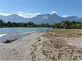
Beach at the village of Juan López
-
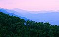
The Merendón range seen from the vantage point located above the "Olimpo merendónico" in San Pedro Sula
-
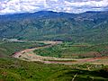
A river in Honduras
-
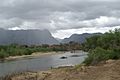
The Rio Guayape near Esquilinchuche, facing El Boqueron in the Sierra de Agalta


See also
 In Spanish: Geografía de Honduras para niños
- List of places in Honduras
