
Syria (region) facts for kids
Quick facts for kids
Syria
ٱلشَّام
Ash-Shām Greater Syria
Syria-Palestine |
|
|---|---|

Above: The Temple Mount with the Dome of the Rock (centre) in the Old City of Jerusalem, 2013
|
|
 |
The region of Syria is a historical area in Western Asia, located east of the Mediterranean Sea. It is also known as Greater Syria, "Syria-Palestine", or the Levant. The Arabic name for this region is Ash-Shām.
Many different groups and empires have controlled this region throughout history. These include the ancient Egyptians, Canaanites, Israelites, Assyrians, Babylonians, and the Achaemenid Empire. Later, the ancient Macedonians, Armenians, Roman Empire, Byzantine Empire, and various Islamic caliphates ruled here. More recently, the Crusaders, Ayyubid dynasty, Mamluk Sultanate, Ottoman Empire, United Kingdom, and the French Third Republic have also held control.
Contents
Exploring the Geography of Syria

Historically, the name 'Syria' often referred to the northern part of the Levant. This included places like Alexandretta and the ancient city of Antioch. Sometimes, it even meant the entire Levant, stretching as far south as Roman Egypt. However, it usually did not include Mesopotamia.
What is Greater Syria?
The area known as "Greater Syria" is also called "Natural Syria" or "Northern Land" (Bilād ash-Shām in Arabic). This region roughly matches the medieval Arab caliphates' province of Bilad al-Sham. It covers the Eastern Mediterranean (Levant) and Western Mesopotamia.
The Muslim conquest of the Levant in the 7th century helped define this province. It largely matched the idea of Greater Syria. Some sources say the term "Greater Syria" was first used during the Ottoman rule after 1516. It described the areas of present-day Palestine, Syria, Jordan, Lebanon, and Israel.
Syria and Assyria: A Name Puzzle
It can be confusing because the names "Syria" and "Assyria" sound very similar. For a long time, people often used these names as if they meant the same thing. However, in the Roman Empire, 'Syria' and 'Assyria' became two separate places: Roman Syria and Roman Assyria.
Natural Borders of the Syrian Region
Experts Killebrew and Steiner describe the borders of the Syrian region (the Levant) like this:
- To the west: The Mediterranean Sea.
- To the east: The Arabian Desert and Mesopotamia.
- To the north: The Taurus Mountains in Anatolia.
Pliny the Elder and Pomponius Mela thought Syria covered the entire Fertile Crescent. Later, "Syria" meant the area east of the Mediterranean Sea, west of the Euphrates River, north of the Arabian Desert, and south of the Taurus Mountains. This includes modern Syria, Lebanon, Jordan, Israel, the State of Palestine, and parts of southern Turkey.
This later definition is similar to the region known in Classical Arabic as ash-Shām. This name means "the north [country]". After the Islamic conquest of Byzantine Syria in the 7th century, the name Syria was less used in the region itself. It was replaced by the Arabic Bilād ash-Shām ("Northern Land"). However, the name "Syria" continued to be used in Byzantine and Western European writings. In the 19th century, the name Syria came back into use in its modern Arabic form, Suriyah or Suriyya, to mean the whole Bilad al-Sham region.
Understanding the Name "Syria"
The word 'Syria' has a long history. The oldest known use of the name is from the 8th century BC. It appeared in an ancient inscription written in two languages: Hieroglyphic Luwian and Phoenician. In this inscription, the Luwian word Sura/i was translated as ʔšr, which meant "Assyria".
Where Did the Name Come From?
The name 'Syria' comes from the ancient Greek name for Syrians, Syrioi. The Greeks used this name for many people in the Near East who lived under the rule of Assyria. Modern studies show that the Greek word comes from Assyria, which itself came from the Akkadian word Aššur.
The classical Arabic way to say Syria is Sūriya. This name was not widely used by Muslims before about 1870, but Christians used it earlier. In early Christianity, "Syrian" sometimes meant "Christian." In English, "Syrian" used to refer to a Syrian Christian. After Syria became a country in 1936, "Syrian" started meaning a citizen of that country, no matter their background. The word "Syriac" is now often used to specifically mean the ethnic group, to avoid confusion.
Today, the Arabic term Sūriya usually refers to the modern country of Syria. It is different from the historical region of Syria.
The Meaning of "Shaam"
Greater Syria is also widely known as Shaam (Ash-Sām in Arabic). In Arabic, this term means "the left-hand side" or "the north." This is because if someone in the Hejaz (a region in Saudi Arabia) faced east towards the sunrise, north would be to their left. This is opposite to Yemen, which means "the right-hand side" or "the south."
The root of Shaam can also mean "unluckiness." This is traditionally linked with the left hand and cold north winds. Yemen, on the other hand, is linked with good fortune and warm south winds.
The Shaam region is sometimes described as the area controlled by Damascus. Damascus has long been an important city in the region. In fact, the word Ash-Sām can even refer to the city of Damascus itself. Damascus was a major trading city for the north, just as Sanaa was for the south.
The Quran mentions caravans traveling to Syria in the summer to avoid cold weather and selling goods in Yemen in the winter.
The name Shaam is not connected to Shem, Noah's son, whose name in Arabic is Sām. However, people have often made a folk connection between the two names and the region.
Historically, Baalshamin was a sky god in Canaan/Phoenicia and ancient Palmyra. Here, "Sham" refers to "heaven" or "sky." In Hebrew, sham comes from the Akkadian word šamû, also meaning "sky." For example, the Hebrew word for the Sun, shemesh, means "sky-fire" (sham for sky and esh for fire).
A Look at Syria's History

Ancient Syria's Beginnings
The ancient Greek historian Herodotus used the name Syria to describe a large area. It stretched from the Halys river in modern-day Turkey down to Mount Casius. Herodotus also said that Syria included the entire Phoenician coast and cities like Cadytis (Jerusalem).
Syria in Greek and Roman Times
In ancient Greek, Syria and Assyria were often used to mean the same thing. But when the Roman Empire came along, Syria and Assyria became distinct places. Roman Syria referred to the parts of the Empire between Asia Minor and Egypt, which is the western Levant. Assyria, however, was mostly part of the Persian Empire and was only briefly controlled by Rome.
Roman Syria: A Major Province

During the Roman era, the term Syria covered the entire northern Levant. Its northeastern border was not always clear. Pliny the Elder said it included, from west to east, the Kingdom of Commagene, Sophene, and Adiabene, which was "formerly known as Assyria." Many writers of this time used "Syria" to describe the whole Levant region. The New Testament also used the name in this broad sense many times.
In 64 BC, Syria became a province of the Roman Empire after being conquered by Pompey. Roman Syria bordered Judea to the south and Greek areas in Anatolia to the north. It was always in conflict with the Parthians to the east.
In 135 AD, Syria-Palaestina was formed, covering the entire Levant and Western Mesopotamia. In 193 AD, the province was split into Syria proper (Coele-Syria) and Phoenice. Later, around 341 AD, the province of Euphratensis was created from parts of Syria Coele and the former area of Commagene, with Hierapolis as its capital.
After about 415 AD, Syria Coele was divided again into Syria I (with its capital still at Antioch) and Syria II or Salutaris (with its capital at Apamea on the Orontes River). In 528 AD, Justinian I created a small coastal province called Theodorias from parts of both provinces.
Bilad al-Sham: The Islamic Era

The region became part of the Rashidun Caliphate after the Muslims defeated the Byzantine Empire at the Battle of Yarmouk. It then became known as the province of Bilad al-Sham. During the Umayyad Caliphate, the Shām region was divided into five junds, or military districts. These were:
- Jund Dimashq (for the area around Damascus)
- Jund Ḥimṣ (for the area around Homs)
- Jund Filasṭīn (for the area around Palestine)
- Jund al-Urdunn (for the area around Jordan)
Later, Jund Qinnasrîn was created from a part of Jund Hims. The city of Damascus was the capital of the Islamic Caliphate until the Abbasid Caliphate rose to power.
Ottoman Syria: A New Division
In later Ottoman times, the region was divided into wilayahs or sub-provinces. Their borders and capital cities changed over time. These included the vilayets of Aleppo, Damascus, and Beirut, plus two special districts: Mount Lebanon and Jerusalem.
- Aleppo covered northern modern-day Syria and parts of southern Turkey.
- Damascus covered southern Syria and modern-day Jordan.
- Beirut covered Lebanon and the Syrian coast from Latakia south to the Galilee.
- Jerusalem covered the land south of the Galilee and west of the Jordan River and the Wadi Arabah.
Even though most people in the region were Sunni Muslims, there were also many other groups. These included Shi'ite, Alawite, and Ismaili Muslims. There were also Syriac Orthodox, Maronite, Greek Orthodox, Roman Catholic, and Melkite Christians, as well as Jews and Druze.
-
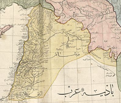
1803 Cedid Atlas, showing Ottoman Syria in yellow
-
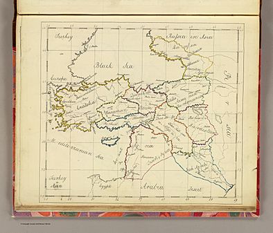
An 1810 map of the Ottoman Empire in Asia, showing the region of Ottoman Syria
-
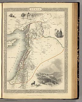
Map of Ottoman Syria from 1851
-
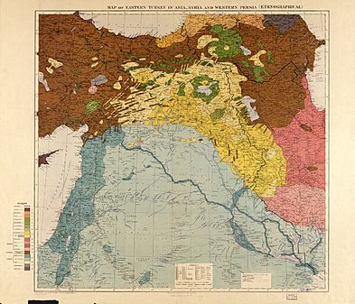
Ethnic groups in the Middle East shown in a pre-World War I British government map. The primary population of the region of Syria is described as "Arabs (settled)" and inland as "Arabs (nomadic)"
_1803.jpg)


The Arab Kingdom and French Control
.jpg)
After World War I, the Occupied Enemy Territory Administration (OETA) was set up. This was a British, French, and Arab military government that controlled parts of the former Ottoman Empire between 1917 and 1920. A strong feeling of Arab nationalism grew, leading to the creation of the first modern Arab state. This was the Hashemite Arab Kingdom of Syria, declared on March 8, 1920.
The new kingdom claimed the entire region of Syria. However, it only controlled the inland area known as OETA East. This led to the quick declaration of the French Mandate for Syria and the Lebanon and the British Mandate for Palestine at the San Remo conference in April 1920. Soon after, in July 1920, the Franco-Syrian War began. French armies defeated the new kingdom and captured Damascus, ending the Arab state.
After this, the French general Henri Gouraud divided the French Mandate of Syria into six smaller states. This was against the rules of the mandate. These states were:
- The State of Damascus (1920)
- The State of Aleppo (1920)
- The Alawite State (1920)
- The Jabal Druze (1921)
- The autonomous Sanjak of Alexandretta (1921), which is now Hatay in Turkey
- Greater Lebanon (1920), which later became the modern country of Lebanon
Pan-Syrian Nationalism: A Vision for the Future

The borders of the Syrian region have changed many times throughout history. In modern times, they were last defined by the short-lived Arab Kingdom of Syria and then by agreements between the French and British. After World War I, the area was given to French and British Mandates. It was divided into Greater Lebanon, various Syrian-mandate states, Mandatory Palestine, and the Emirate of Transjordan.
The Syrian-mandate states slowly joined together to form the State of Syria. This state finally became the independent country of Syria in 1946. During this time, Antoun Saadeh and his political party, the Syrian Social Nationalist Party, had a vision for "Greater Syria" or "Natural Syria." This idea was based on the historical connection between the names "Syria" and "Assyria." Their vision of "Natural Syria" included:
- The Sinai Peninsula
- Cyprus
- Modern Syria
- Lebanon
- Palestine
- Jordan
- Iraq
- Kuwait
- The Ahvaz region of Iran
- The Kilikian region of Turkey
Religious Importance of the Region
The region of Syria holds many sites that are very important to Abrahamic religions, including Judaism, Christianity, and Islam.
| Place | Description | Image |
|---|---|---|
| Acre | Acre is home to the Shrine of Baháʼu'lláh. This is the holiest site for the Baháʼí Faith. | |
| Aleppo | Aleppo has a Great Mosque. Many believe it holds the remains of Zechariah. He is honored in both Christianity and Islam. | |
| Bethlehem | Bethlehem has important sites for Jews, Christians, and Muslims. Rachel's Tomb is one such place, respected by all three faiths. The Church of the Nativity (where Jesus was born) is important to Christians. Nearby, the Mosque of Omar is important to Muslims. | |
| Damascus | The Old City has a Great Mosque. It is one of the largest and best-preserved mosques from the Umayyad Caliphate era. It is believed to hold the remains of John the Baptist, son of Zechariah. John is honored in Christianity and Islam. Other important sites include Bab al-Saghir and Sayyidah Ruqayyah Mosque. | |
| Haifa | Haifa is where the Shrine of the Báb is located. This site is holy to the Baháʼí Faith.
Nearby is Mount Carmel. This mountain is linked to the Biblical figure Elijah. It is important to Christians, Druze, Jews, and Muslims. |
|
| Hebron | The Old City is home to the Cave of the Patriarchs. It is believed that Abraham, his wife Sarah, their son Isaac, his wife Rebecca, their son Jacob, and his wife Leah are buried here. Followers of Abrahamic faiths, including Muslims and Jews, honor this site. | |
| Hittin | Hittin is near what is believed to be the shrine of Shuaib (possibly Jethro). This site is holy to Druze and Muslims. | |
| Jericho / An-Nabi Musa | Near the city of Jericho in the West Bank is the shrine of Nabi Musa (meaning Prophet Moses). Muslims believe this is the burial place of Moses. | |
| Jerusalem | The Old City is holy to Christianity, Islam, and Judaism. It has sites like the Church of the Holy Sepulchre, Western Wall, and Al-Aqsa Mosque. |

.jpg)


.jpg)
_C.JPG)


.jpg)
See also
 In Spanish: País de Sham para niños
