
Homs facts for kids
Quick facts for kids
Homs
حِمْص
|
|
|---|---|
|
City
|
|
    Homs city landmarks
Martyrs' Square with the Old Clock • Khalid ibn al-Walid Mosque • Al-Baath University • Khalid ibn al-Walid Stadium |
|
| Nickname(s):
Mother of the black stones (أم الحجار السود)
Al-'Adhiyyah (الْعَذِيَّة) The city of Ibn Al-Walid (مدينة ابن الوليد) The House of Peace (دار السلام) |
|

Homs
Location in Syria

Homs
Location in Eastern Mediterranean

Homs
Location in Asia
|
|
| Country | |
| Governorate | Homs Governorate |
| District | Homs District |
| Subdistrict | Homs Subdistrict |
| First settled | 2000 BC |
| Area | |
| • City | 48 km2 (19 sq mi) |
| • Urban | 76 km2 (29 sq mi) |
| • Metro | 104 km2 (40 sq mi) |
| Elevation | 501 m (1,644 ft) |
| Population
(2017, est.)
|
|
| • City | 775,404 |
| • Density | 16,150/km2 (41,800/sq mi) |
| Demonyms | English: Homsi Arabic: حمصي, romanized: Himsi |
| Time zone | UTC+2 (EET) |
| • Summer (DST) | UTC+3 (EEST) |
| Area code(s) | Country code: 963 City code: 31 |
| Geocode | C2528 |
| Climate | Csa |
Homs is a large city in western Syria. It is the capital of the Homs Governorate. The city is about 501 meters (1,644 feet) above sea level. It is located 162 kilometers (101 miles) north of Damascus. Homs sits on the Orontes River. It connects cities in the middle of Syria to the Mediterranean Sea coast.
Before the recent conflict, Homs was a big industrial center. In 2004, it had over 652,000 people. This made it the third-largest city in Syria. Its people come from different religious backgrounds. These include Sunni and Alawite Muslims, and Christians. The city has many old mosques and churches. It is also near the famous Krak des Chevaliers castle, a World Heritage Site.
Homs became known in history around the 1st century BC. It was then the capital of a kingdom ruled by the Emesene dynasty. This dynasty gave the city its old name, Emesa. It was first a place to worship the sun god El-Gabal. Later, it became important for Christianity under the Byzantine Empire. Muslims took control of Homs in the 7th century. They made it the capital of a district. Throughout history, different Muslim rulers wanted Homs. This was because of its important location. The city became less important under the Ottoman Empire. But in the 1800s, its cotton industry grew. This made it economically important again. After Syria became independent in 1946, Homs was a center of political activity. In recent years, parts of the city faced challenges and were damaged. Reconstruction efforts began in 2018.
Contents
Understanding the Name of Homs
The modern name, Homs, comes from the city's old Latin name, Emesus. This name came from the Greek words Émesa or Émesos.
Many believe the name Emesa came from a nomadic Arab tribe. This tribe, called Emesenoi by the Greeks, lived in the area. The Arab people who lived there shortened Émesa to Homs or Hims. This happened even before Muslims took over Syria.
Some people think Émesa came from the Aramaic city of Hamath-zobah. Hamath means "fortress," and Sawbah means "nearness." So, the name could mean "The fortress surrounding." This might refer to the Citadel of Homs and the plains around it.
Later, during the Crusades, the Crusaders called the city "la Chamelle." This means "the female camel" in French. But it was likely a changed version of the Arabic name.
A Look at Homs' Long History
For about 2,000 years, Homs has been a key place for farming, making goods, and trading. It also helped protect Syria from invaders. Digs at the Citadel of Homs show people lived there around 2300 BCE. Some scholars think it's the same city as Hamath-zobah mentioned in the Bible. A huge battle with many chariots happened near Homs in 1274 BCE. This was between the Egyptians and the Hittites.
Ancient Kingdoms and Roman Times
Homs became a major city because of the Emesene dynasty. This family made Homs their capital. They were loyal to the Roman Republic. They helped the Romans in different wars. Their kingdom stretched from the Bekaa Valley in the west to Palmyra in the east. It also went from Yabrud in the south to al-Rastan in the north.
.jpg)

The Emesene rulers helped the Romans in battles. For example, they sent soldiers to help Julius Caesar in 48 BC. Later, one king, Sohaemus, sent archers to help the Romans in their siege of Jerusalem in 70 AD. After Sohaemus died, the kingdom likely became part of the Roman province of Syria.


Under Roman rule, Emesa grew into a big city. It started making its own coins around 138–161 AD. By the 200s AD, it was a rich city. This was partly because Emperor Lucius Septimius Severus married a woman from a powerful family in Emesa. The city was also important for trade, connecting to Palmyra.
Emesa was a strong center for worshipping the sun god El-Gabal. The emperor Elagabalus was a high priest for this god. He even brought the god's image, a black stone, to Rome.
.jpg)

Because of the strong sun cult, Christians didn't settle in Emesa at first. But by the 400s, Christianity was well-established. The city became an important center for Eastern Christianity. Homs became a major religious center after the head of John the Baptist was found nearby in 452.
Homs Under Muslim Rule
Before the Muslim conquest of the Levant, Arab tribes lived around Emesa. In 637 CE, the Rashidun army, led by Khalid ibn al-Walid, took over Emesa peacefully. The people agreed to pay a large sum of money. Caliph Umar made Homs the capital of a district called Jund Hims. This district included coastal towns and Palmyra. Homs was probably the first city in Syria with many Muslim residents.
Muslims turned half of St. John's Church into the city's main mosque, the Great Mosque of al-Nuri. Homs became a place of Islamic faith. Many of Muhammad's companions settled there. The tombs of Khalid ibn al-Walid and others are in the city.
During the First Fitna, a conflict between Muslim groups, Homs sided with Ali. Later, the Umayyad dynasty took control. Homs remained a center for some time. But the last Umayyad caliph, Marwan II, destroyed the city walls after a rebellion.
In 750, the Abbasid Caliphate took over Syria, including Homs. Even though Homs was doing well, Abbasid rule was not always popular. There were several revolts. In 855, Christians in Homs rebelled against new taxes. The caliph stopped the revolt by forcing Christians out and burning churches.
As Abbasid rule weakened, different groups fought for control of Homs. This was because of its important location. The Tulunids and then the Hamdanids ruled the city. In the early 900s, a geographer said Homs was known for its beautiful people. In 985, another geographer said Homs was the largest city in Syria.
In the 900s, the Byzantine Empire raided Homs several times. The city was plundered, and the Great Mosque was briefly turned back into a church. Later, the Mirdasids ruled Homs. Then, the Saljuqid Turks took control in 1090.
Saljuqid, Ayyubid, and Mamluk Periods
When the First Crusade began in 1096, Crusaders tried to take Homs but failed. Homs then became a strong fortress under Duqaq, the Saljuqid ruler of Damascus. This stopped the Crusaders from going further into Muslim lands. Homs became a place where Muslims gathered to fight the Crusaders. In 1149, the Zangids, led by Nur al-Din, captured the city.
In 1154, a geographer described Homs as a busy city with paved streets and large markets. He said its people were pleasant and its women beautiful. Earthquakes in 1157 and 1170 damaged Homs and its fortress. But because of its important location, the city and its defenses were quickly rebuilt.
Saladin took Homs in 1174. In 1179, he gave Homs back to his Ayyubid dynasty. The Ayyubid rulers kept Homs for almost a century. In 1225, a geographer noted that Homs was a large, famous, walled city with a strong castle.


Towards the end of Ayyubid rule, Homs was a key place in wars. These wars were between the Ayyubids, Crusaders, Mongols, and Mamluks. The Mamluks won two major battles against the Mongols in Homs in 1260 and 1281.
Homs became less important after the Mamluks took full control of Syria. In the early 1300s, it was the capital of Syria's smallest province. A traveler in 1355 said Homs had nice trees, good markets, and a "fine Friday Mosque." He noted that all its people were Arabs. Timur captured the city in 1400 but did not destroy it. In the 1400s, Homs suffered from raids by Bedouin tribes.
Homs Under Ottoman Rule
In 1516, Homs became part of the Ottoman Empire. It lost some political power but continued to be an important economic center. It processed farm products from nearby areas. Homs was especially known for weaving silk and wool. This cloth was even sent to the Ottoman capital, Istanbul. The city also had olive oil presses and mills for wheat and sesame. Its markets traded livestock like sheep, goats, and camels.

Under the Ottomans, Homs became the capital of its own district. In the late 1500s, a French visitor said the city walls were in good shape, but much of the city was in decline. In 1785, another traveler described Homs as a large but ruined village. The Ottomans did little to protect Homs from Bedouin raids. The city gates were even torn down in the 1700s.
The countryside around Homs saw more Bedouin raids in the early 1800s. Egyptian forces occupied Homs from 1832 to 1840. The city rebelled, and the citadel was destroyed when the Egyptians stopped the revolt. Ottoman rule returned, and by the 1860s, Homs was a major trading hub for farm products.


The local economy improved when the Ottomans made the area safer. New villages were built. Homs faced competition from Europe. But during an economic downturn in the 1870s, its cotton industry boomed. This was because European textile production went down. Homs' cotton goods were popular. There were about 5,000 looms in Homs and nearby Hama. One British official called Homs the "Manchester of Syria."
Homs in Modern Times

Throughout the 1900s, Homs was politically important. Many leaders and government officials came from Homs. In October 1918, Allied forces captured the city. During the French mandate, Homs was part of the State of Damascus. In 1925, the city joined a large revolt against French rule.
In 1932, the French moved their military academy to Homs. This academy trained officers for the local military force. Many graduates became high-ranking officers in the Syrian Army. An important example is Hafez al-Assad, who became president of Syria.


An oil pipeline was built in Homs in the early 1930s. In 1959, an oil refinery was built to process oil for Syria. The refinery was bombed during the 1973 Yom Kippur War.
From 2011 to 2014, Homs faced a difficult period. Parts of the city were damaged due to conflict. Reconstruction efforts began in 2018 to rebuild affected areas. In December 2015, some anti-government forces and their families left the city as part of a UN agreement.
Exploring Homs' Geography

The Homs Governorate is the largest in Syria. Homs, its capital, is in central western Syria. It lies on the east bank of the Orontes River in a very fertile area. The city is between the Syrian Coastal Mountain Range to the west and Mount Lebanon. It sits in the Homs Gap, a pass through the mountains. This gap means Homs gets more rain and wind than other inland areas. To the east of Homs is the Syrian Desert. Lake Homs, created by an old Roman dam, is to the southwest. Homs is about 125 kilometers (78 miles) south of Aleppo and 34 kilometers (21 miles) south of Hama. It's halfway between Damascus and Aleppo.
The Orontes River divides Homs into two main parts. To the east is the city center and older neighborhoods. To the west is the newer suburb of al-Waer. The city covers an area of about 48 square kilometers (18.5 square miles).
Homs is 162 kilometers (101 miles) north of Damascus. It's 193 kilometers (120 miles) south of Aleppo. It is also 47 kilometers (29 miles) south of Hama. And it is 186 kilometers (116 miles) southeast of Latakia on the Mediterranean coast. Many towns and villages are located near Homs.
Old City and Modern Areas
The Old City is the most crowded part of Homs. It includes neighborhoods like Bab Tadmur and Bab al-Dreib. This area covers about 1.2 square kilometers (0.46 square miles). Not much of the old city walls remain. They were torn down during Ottoman times. But a small part of a fortified wall with a round tower still stands. South of the old city, a large mound shows where the citadel once was.
North of the citadel is the Christian Quarter, called "al-Hamidiyah." This area still has many old buildings. Most of these buildings are from the Mamluk era. They are made with alternating black-and-white stones. These buildings are still used as shops and homes.
In the past, Homs was known for its seven gates. Only two gates, Bab Tadmor and Bab al-Dreib, remain today. The oldest mosques and churches in Homs are found in the Old City.
Outside the Old City, Homs has many other areas. Khaldiyah is a large neighborhood to the north. Modern neighborhoods like al-Sabil and al-Zahra are east of the Old City. South of it are areas like Bab al-Sebaa and al-Nezha. The main shopping area is in Jouret al-Shayyah to the west. Further west are upscale neighborhoods like Qusoor and al-Mahatta. The suburb of al-Waer is even further west. It is separated from the city by farms and the Orontes River. The Baath University is on the western-southern edge of the city.
=Homs' Climate
Homs has a hot-summer Mediterranean climate. This means it has hot, dry summers and mild, wet winters.
Because of its location, Homs gets gentle breezes from the Mediterranean Sea. This gives it a milder climate than nearby Hama. Homs also gets more rain, about 18 inches (457 mm) per year. But it also has stronger winds.
| Climate data for Homs (1952–2004 normals) | |||||||||||||
|---|---|---|---|---|---|---|---|---|---|---|---|---|---|
| Month | Jan | Feb | Mar | Apr | May | Jun | Jul | Aug | Sep | Oct | Nov | Dec | Year |
| Mean daily maximum °C (°F) | 11.1 (52.0) |
13.0 (55.4) |
16.6 (61.9) |
21.6 (70.9) |
27.0 (80.6) |
30.8 (87.4) |
32.3 (90.1) |
32.8 (91.0) |
31.3 (88.3) |
26.9 (80.4) |
19.1 (66.4) |
12.5 (54.5) |
22.9 (73.2) |
| Daily mean °C (°F) | 7.0 (44.6) |
8.2 (46.8) |
11.1 (52.0) |
15.4 (59.7) |
20.0 (68.0) |
24.0 (75.2) |
26.1 (79.0) |
26.5 (79.7) |
24.4 (75.9) |
19.8 (67.6) |
13.1 (55.6) |
8.2 (46.8) |
17.0 (62.6) |
| Mean daily minimum °C (°F) | 2.8 (37.0) |
3.3 (37.9) |
5.6 (42.1) |
9.2 (48.6) |
13.0 (55.4) |
17.1 (62.8) |
19.8 (67.6) |
20.1 (68.2) |
17.5 (63.5) |
12.7 (54.9) |
7.0 (44.6) |
3.8 (38.8) |
11.0 (51.8) |
| Average precipitation mm (inches) | 95.1 (3.74) |
76.5 (3.01) |
56.4 (2.22) |
33.3 (1.31) |
13.0 (0.51) |
2.6 (0.10) |
0.2 (0.01) |
0.0 (0.0) |
2.4 (0.09) |
21.1 (0.83) |
48.1 (1.89) |
80.7 (3.18) |
429.4 (16.89) |
| Average precipitation days (≥ 1mm) | 13 | 15 | 10 | 6 | 3 | 0 | 0 | 0 | 1 | 4 | 7 | 11 | 70 |
| Mean daily sunshine hours | 4 | 6 | 7 | 8 | 10 | 12 | 12 | 12 | 10 | 8 | 6 | 5 | 8 |
| Mean daily daylight hours | 10.1 | 11 | 12 | 13.1 | 14 | 14.5 | 14.2 | 13.4 | 12.4 | 11.3 | 10.4 | 9.9 | 12.2 |
| Average ultraviolet index | 3 | 4 | 6 | 8 | 9 | 11 | 11 | 11 | 8 | 6 | 3 | 2 | 7 |
| Source 1: WMO | |||||||||||||
| Source 2: Weather Atlas(sun-daylight-UV) | |||||||||||||
People and Population of Homs
| Homs Religions | ||||
|---|---|---|---|---|
| Sunni Muslims | 75% | |||
| Alawite | 15% | |||
| Christians | 10% | |||
| Year | Population |
|---|---|
| 12th century | ~7,000 |
| 1785 | ~2,000 |
| 1860s (estimate) | 15,000–20,000 |
| 1907 (estimate) | ~65,000 |
| 1932 | 65,000 |
| 1960 | 136,000 |
| 1978 | 306,000 |
| 1981 | 346,871 |
| 1994 | 540,133 |
| 2004 | 652,609 |
| 2005 (estimate) | 750,000 |
| 2008 (estimate) | 823,000 |
| 2011 (estimate) | 806,625 |
| 2013 (estimate) | 544,428 |
| 2017 (estimate) | 775,404 |

Homs was one of Syria's largest cities in the 12th century, with about 7,000 people. By 1785, its population was over 2,000. In the 1860s, it grew to 15,000–20,000. By 1907, Homs had about 65,000 residents.
Today, Homs has a diverse population. It includes mostly Sunni Muslims (Arabs, Kurds, and Turkmen). There are also minorities of Alawites, Eastern Orthodox Christians, and Assyrians. Other Christian groups like Catholics and Maronites also live there.
In the early 1900s, about 20,000 Armenians moved to Homs and nearby villages. A small Greek community still lives in the city.
Homs' Economy and Industry

After a quiet period under Ottoman rule, Homs began to grow again in the 1900s. Its location makes it a center for farming and industry. The "Homs Irrigation Scheme" helped farmers and businesses. Crops like wheat, barley, lentils, sugar beets, and cotton are grown. Homs also serves as a trading point between settled areas and the desert. Its easy access to the Mediterranean Sea has attracted trade from the Persian Gulf and Iraq.

Homs has several large public industries. An oil refinery opened west of the city in 1959. A fertilizer plant was built in 1971. It processes phosphates from nearby deposits. This fertilizer is used in Syria and exported. Many small to medium-sized private businesses have also grown. These are in industrial zones northwest and south of the city. New factories for sugar and cars are being built. Homs is also a key point in Syria's road and rail network. It connects inland cities to the Mediterranean coast.
A major industrial project is a new industrial city in Hisyah. It is 47 kilometers (29 miles) south of Homs. This city covers about 25 square kilometers (9.6 square miles). It has four main industrial areas: textiles, food, chemicals, and engineering. It is designed to employ up to 66,000 workers. There is also a free trade zone within the city.
The area around Homs is known for its grapes. These grapes are used to make Syrian liqueurs like arak and wine. Homs is a good starting point for trips to historical sites. Popular places to visit include Krak des Chevaliers, Qatna, and Marmarita. Homs has several hotels for visitors.
Culture and Traditions in Homs
Homs' Unique Cuisine

People in Homs eat many foods common in Levantine cuisine. But the city is famous for its own special dishes. One popular dish is Batarsh. It's like baba ghanouj but made with yogurt and garlic. Homs also has a special grilled kibbeh. It's made of two kibbeh pancakes stuffed with ground lamb and spices. Jazar Mahshi ("stuffed carrot") is another local dish. It's yellow carrots stuffed with minced lamb and rice. The city is also known for its okra meal, bamya bi-l zayt ("okra with olive oil").
Homs has many restaurants. Some serve Italian cuisine, while others offer Arabic food. Local favorites include shawarma, grilled chicken, and fresh juices. In the Old City, you can find affordable restaurants along Shoukri al-Quwatly Street. They sell foods like hummus, falafel, salads (mezze), and shish kebab. Many restaurants and coffeehouses offer hookahs, where people gather to smoke.
Museums to Explore

Homs has two main museums in the city center. Qasr al-Zahrawi is a former Mamluk-era palace. It now houses the National Folklore Museum. Outside, there's a large courtyard with a special arched area called a liwan. On the opposite wall, you can see a carving of two lions, a symbol of the Mamluk sultan Baibars.
The first museum in the city, Homs Museum, opened in 1922. It's on Shoukri al-Quwatly Street. It displays artifacts from the Homs region. These items cover history from prehistoric times to the Islamic era.
Festivals and Celebrations
Homs hosts several festivals. The city helps organize the Desert Folk Festival and the Al-Badiya Festival with Palmyra. The Desert Folk Festival celebrates the old traditions and costumes of the Syrian Desert. It includes exhibitions and concerts in Homs and Palmyra. This festival happens in the first week of May.
The Al-Badiya Festival is mostly in Palmyra, with some events in Homs. It attracts about 60,000 tourists in the last week of May. Activities include horse, camel, and car races, music shows, and craft markets. Other festivals include the al-Nasarah Festival and the Festival of Krak des Chevaliers. An annual festival at the Church of Saint Elian attracts many visitors.
Historically, Wednesday was an important day for Homs citizens. This is linked to events in the city's past. During the Emesene dynasty, people worshipped the sun god Elagabalus. They held ceremonies at the great "Temple of the Sun" on the "fourth day" of the week. This was to celebrate the creation of the Sun.
Sports in Homs
Homs is home to two football clubs. The Al-Karamah Sports Club was founded in 1928. It is one of Syria's oldest sports clubs. Al-Karamah has won many Syrian League and Syrian Cup titles. It was also a runner-up in the 2006 AFC Champions League. The city's second club is Al-Wathba Sports Club, founded in 1937.
The Khaled ibn al-Walid Stadium can hold 35,000 people. Both football clubs use this stadium. Another stadium, Bassel al-Assad Stadium, opened in 2000. It has a capacity of 25,000. Homs has produced famous football players like Firas Al Khatib and Jehad Al Hussain.
Theaters for Arts and Culture
The Culture House Theater in Homs opened in 1973. It hosts many events. These include theatre plays, poetry readings, and music festivals.
Learning and Education in Homs

Some of the oldest schools in Homs were started by American missionaries. These include the "National Evangelical School" in 1855 and "Al Ghassania Orthodox School in 1887.
Homs is home to Al-Baath University. It is one of Syria's four major universities, founded in 1979. This university specializes in engineering. It has one of the largest student populations in Syria. It offers many subjects, including medicine, engineering, liberal arts, and sciences. It also has two-year vocational programs. It is the only university in Syria with departments for petroleum engineering and veterinary medicine.
The German University opened in 2004. It is located 30 kilometers (19 miles) west of Homs. In 2005, the International School of Choueifat opened a school outside the city. Al-Andalus University for Medical Sciences was also established near Homs in 2005. It is building one of its University Hospitals in the city.
The Homs Governorate has 1,727 schools and 15,000 kindergartens. Most of these are public schools. In 2007, about 375,000 students were in elementary schools. Another 36,000 were in high schools. About 12,000 students were in vocational training schools.
Getting Around Homs
Transportation Links
Homs is a major transportation hub in Syria. This is because it's located in the middle of the country. It connects coastal cities to inland areas. The main bus station is Karnak. It's about 1.5 kilometers (0.9 miles) north of the city center. From here, you can travel to most Syrian cities and Beirut, Lebanon. There are also international bus routes to Lebanon, Jordan, Saudi Arabia, and Turkey. A second "luxury" bus station is a bit further north.
Minibuses also operate from Karnak station. They go to places like Tartus, Palmyra, and Hama in northern Syria. They also travel to Baalbek, Tripoli, and Beirut in Lebanon. Newer microbuses, mostly going to Hama, are also based at Karnak.

Homs has a large railway station. There are daily trains to Damascus and Aleppo. The closest airports are Bassel Al-Assad International Airport in Latakia (west), Damascus International Airport (south), Aleppo International Airport (north), and Palmyra Airport (east).
Hama Street starts at the Old Clock Square in the city center. It goes through Homs from south to north. It then becomes the Homs-Hama-Aleppo highway. Quwatli Street, named after a former president, is a short but important street. It connects the Old Clock Square and Quwatli Square in Downtown Homs. It leads to smaller streets, including al-Dablan Street, which is the main shopping area. The Homs-Tripoli highway connects further west. The Homs-Damascus highway enters the city from the south and reaches Quwatli Square.
Famous Landmarks of Homs


Homs is known for its historic mosques and churches. It also has two famous public clocks. One is the older clock, put up by the French in 1923. It's at the eastern end of Quwatli Street. The other is in the New Clock Tower, built in 1957. It's at the western end of the street.
Homs is well known for its historic covered souks (markets). These are a maze of narrow streets and covered shops. They stretch from the Great Mosque towards the old citadel. These markets are full of grocery and clothing stores. They also have workshops for carpenters, artisans, and metalworkers. The souks are busiest in the evening.
The Great Mosque of al-Nuri was once a pagan temple. It was later a church and then became a mosque. The Khalid ibn al-Walid Mosque is another important building. It was built in the early 1900s. It is named after the general Khalid ibn al-Walid, whose tomb is inside.
The Um al-Zennar Church ("Church of the Virgin's Girdle") was built in 1852. It stands on top of an even older church from the 4th century. The 5th-century Church of Saint Elian is also in Homs. It honors the Christian martyr Saint Elian, whose tomb is in the church's basement.
The Citadel of Homs is on one of Syria's largest ancient mounds. Its current walls were built during the Ayyubid period. The Mamluk sultan Baybars later restored them.
Sister Cities of Homs
Homs is twinned with:
 Belo Horizonte, Brazil
 Kayseri, Turkey
 Yazd, Iran
Images for kids
-
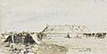
The Citadel behind a camp of the Australian Light Horse on 19 November 1918 (James McBey)
See also
 In Spanish: Homs para niños
