
History of urban planning facts for kids
Urban planning is all about how we design and manage our cities and towns. It looks at how land is used, how buildings are placed, and how things like roads, water pipes, and electricity networks are set up. It’s like creating a giant blueprint for a whole community!
The idea of planning cities isn't new at all. In fact, it goes way back to some of the very first cities ever built. People have always tried to organize their living spaces.
Contents
Ancient City Designs
Even in ancient times, people planned their cities. Civilizations like the Minoans, Mesopotamians, and Egyptians designed cities with specific layouts thousands of years ago.
Early Planned Cities
One of the oldest stories about city planning comes from the Epic of Gilgamesh. It describes the ancient city of Uruk as being carefully built with different areas for the city, orchards, and clay pits.
The Indus Valley Civilisation (in modern-day India and Pakistan) had some of the earliest known planned cities, like Harappa and Mohenjo-daro. Their streets were often paved and laid out in a straight grid pattern, like a checkerboard. They had main roads and smaller alleys. Many houses were built to be quiet and private, and some even had their own water wells and drainage systems. This shows they cared about cleanliness!
In Mesoamerica, many cities in later periods had very organized central areas with public squares and buildings. However, the areas where people lived around these centers were often less planned.
Planning in East Asia
China has a long history of urban planning that goes back thousands of years.
In Japan, some early cities like Nara and Heian-kyo were designed using ideas from Chinese planning. Later, during a time of feudal lords, a new type of town called a Jōkamachi appeared. These were castle towns built around castles for defense. Roads were often made winding to make it harder for attackers to reach the castle, and buildings were sometimes placed to hide the castle. Edo (which is now Tokyo) is a famous example of a castle town.
Greek and Roman City Planning

The Greek philosopher Hippodamus of Miletus (who lived around 400 BC) is often called the "father of city planning." He was known for his grid-like city layouts with square street blocks. While other ancient cultures used grid plans before him, Hippodamus helped make this style popular.
When Greek city-states started building colonies around the Mediterranean Sea, they often created new towns with very regular, straight street patterns. For example, after the city of Miletus was destroyed, it was rebuilt in a very organized way, supposedly based on Hippodamus's ideas.
About a century later, Alexander the Great asked an architect named Dinocrates to design his new city of Alexandria. This city became a great example of planned urban design in the ancient Greek world.
The Romans also used straight, grid-like patterns for their colonies. They were likely inspired by Greek and Etruscan cities. The Roman engineer Vitruvius wrote down important rules for good design that are still studied today.
Roman cities often had a central public area called a forum with important services. Around this, streets were laid out in a compact, straight grid. Rivers were often used for water, transport, and waste. Many European cities today, like Turin, still show parts of these Roman designs. Roman roads were usually made of carefully placed stones. Two main roads, the decumanus (east-west) and the cardo (north-south), crossed in the middle to form the city center. Each square area between four roads was called an insula, similar to a modern city block.
Cities might also have been surrounded by a wall for protection and to mark the city limits. Farmland was kept outside the walls. Large gateways with watchtowers were at the end of main roads.
Medieval European Towns (500–1400)
After the Roman Empire declined, many cities in Western and Central Europe struggled. But around the 10th and 11th centuries, things improved. Trade and crafts grew, and cities started to revive. Many new towns were created, and existing ones grew.
New Towns and Planned Extensions

From the 9th to the 14th centuries, hundreds of new towns were built across Europe, and many old ones were expanded with planned sections. These new towns played a big role in shaping Europe's geography. Lords and rulers founded new towns to gain economic, political, or military power. People were often encouraged to move to these new towns with special benefits like lower taxes.
Many of these new towns were clearly planned. They often had straight streets that met at right angles, and house lots were rectangular and often the same size. A great example is Elburg in the Netherlands, built in the late 14th century. Its very symmetrical layout shows that planned, straight street designs were not just a "Renaissance" invention.
By the mid-14th century, the period of rapid urban growth slowed down, except in Eastern Europe where it continued for a bit longer. It wasn't until the Industrial Revolution that cities would see such a big population boom again.
Renaissance and Baroque Planning (1400–1750)


During the Renaissance, cities like Florence became models for new urban planning. A popular design was the star-shaped city, inspired by new forts built to resist cannon fire. This design was copied widely. It often featured streets spreading out like spokes from a central point of power.
One of the most ambitious urban planning projects in the Baroque Period was in Rome. Pope Sixtus V had a huge plan to transform the old city. He wanted long, straight streets, wide open spaces, and grand buildings. He achieved a lot in his short time, including finishing the dome of St. Peter's, building new palaces, setting up obelisks, and opening new streets.
Rulers often redesigned their capital cities to show off their nation's power. Disasters sometimes led to planned rebuilding. For example, after the Great Fire of London in 1666, architects like Christopher Wren proposed grand plans, but they weren't fully carried out due to complex land ownership. However, improvements were made, like wider streets and stone buildings for fire safety. This event also influenced city planning in North America.
After the bombardment of Brussels in 1695, the city center was destroyed. The governor wanted to rebuild it in a new Baroque style, with straight avenues and uniform buildings, like Turin. But residents wanted a quick rebuild and didn't have the money for such grand plans. So, while the general layout was kept, streets were widened for better traffic and sanitation.
Enlightenment Era Planning (1700–1800)


After the devastating 1755 Lisbon earthquake, King Joseph I of Portugal and his ministers quickly decided to rebuild the city. They chose to clear large sections and create new, wide, straight streets and grand squares. This new "Pombaline" architecture was also designed to be earthquake-resistant.
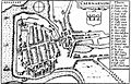
Another important plan from this time was for Edinburgh's New Town in Scotland, built between 1767 and 1850. The old city was outdated, so a competition was held for a new design. James Craig won with a simple grid plan, featuring a main road linking two garden squares. It was mostly for homes and offices, but its commercial potential was soon realized.
Modern Urban Planning (1800–Today)
From the 1800s onwards, urban planning became a more specialized job with its own rules and laws.
Major City Transformations
Regent Street in London was one of the first planned developments there. It was designed by John Nash and built to replace parts of the medieval layout.

A much bigger transformation happened in Paris. In 1852, Georges-Eugène Haussmann was tasked with remodeling the city. He tore down old neighborhoods and created wide boulevards that stretched beyond the city limits. Haussmann's project covered everything: building rules, public parks, sewers, water systems, and monuments. These wide roads also made it easier for troops to move and for police to control the city.
At the same time, a plan to expand Barcelona was created by engineer Ildefons Cerdà. He invented the term 'urbanisation' and based his design on a scientific study of the city's needs. His "Eixample" (meaning 'extension') had 550 regular blocks with cut-off corners to help trams move easily. He wanted to improve health, so blocks were built around central gardens and angled to get maximum sunlight.

Vienna also started building its grand Ringstrasse in 1857, replacing old city walls with a wide boulevard lined with impressive public and private buildings. Similarly, Berlin created its "Binding Land-Use Plan" in 1862, which guided its growth for about 50 years. This plan led to large areas of dense city blocks with mixed-use buildings.
By the turn of the 20th century, people started to see the problems of rapidly growing industrial cities, especially for the working poor. Governments began to get more involved in improving living conditions. Around 1900, experts started creating urban planning models to make cities healthier, especially for factory workers.
Urban Planning as a Profession
Urban planning became a real profession around this time. Engineers, architects, and local leaders worked together to create new designs. Reinhard Baumeister and Josef Stübben were important German urban planners who wrote influential books and advocated for planning that helped the urban poor.
Laws were passed to allow cities to create urban plans and buy land for development. For example, in Germany, the Federal Building Line Act of 1875 gave local authorities the right to set boundaries for streets. France also had laws requiring towns to plan their building lines and street widths.
In Britain, the Town and Country Planning Association was founded in 1899. The first university course on urban planning was offered in 1909. The Housing and Town Planning Act of 1909 made it mandatory for local authorities to plan their towns using new ideas like the 'garden city' concept. This led to surveyors, engineers, architects, and lawyers working together in local government to plan land development. The Town Planning Institute was created in 1914.
The Garden City Movement

Sir Ebenezer Howard started the garden city movement in Britain in 1898. He was inspired by earlier planned communities built by factory owners, like Bournville and Port Sunlight, which offered healthier living spaces for workers outside crowded city centers.
Howard's idea was to create planned, self-sufficient communities surrounded by parks. These "garden cities" would have separate areas for homes, industries, and farms. He published his ideas in his book Garden Cities of To-morrow in 1898, which is considered very important in urban planning history. His ideal garden city would house about 32,000 people on a large piece of land, with a circular pattern, open spaces, public parks, and wide roads spreading out from the center. When one garden city was full, another would be built nearby.
The first garden city, Letchworth, was built in Hertfordshire. Architects Raymond Unwin and Richard Barry Parker planned the town, focusing on affordable housing and green spaces. Welwyn Garden City was also built based on Howard's ideas.
The principles of the garden city were also used to plan city suburbs, like the Hampstead Garden Suburb. This project aimed to create low-density housing with wide, tree-lined roads, open to all people.
In North America, the Garden City movement led to the "Neighbourhood Unit" idea. This design, first seen in Radburn, New Jersey, turned houses towards common public paths instead of streets. Neighborhoods were often organized around a school, so children could walk safely.
Modernist Planning

In the 1920s, modernism began to influence urban planning. The famous architect Le Corbusier proposed his "Contemporary City" plan in 1922. It featured sixty-story skyscrapers in large green parks, with a huge transportation hub. He wanted to separate people walking from cars and loved the idea of cars as transport. He even imagined planes landing between skyscrapers!
In 1925, Le Corbusier showed his Plan Voisin, where he suggested tearing down much of central Paris and replacing it with his skyscrapers and grid-like streets. His ideas were later published in The Radiant City (1935). While his ideas were sometimes used for public housing in Europe and the US, they were not always practical.
Other important planners included Sir Patrick Geddes, who stressed the importance of considering the regional environment and how social issues connect to town planning. He planned the city of Tel Aviv in 1927, which featured blocks with inner public gardens and a street pattern designed to catch sea breezes.
New Towns Movement

After World War II, Ebenezer Howard's ideas for planned communities were widely adopted. The war damage led to a strong desire to rebuild Britain better. Plans for London suggested moving over a million people to satellite suburbs, existing towns, and new towns.
The New Towns Act 1946 led to many New Towns being built in Britain. The United States also built new towns from the 1960s, like Reston, Virginia and Columbia, Maryland. This effort was combined with government money for slum clearance and new roads. Other European countries also built new towns as part of post-war rebuilding.
Urban Planning Today
Urban planning has become even more important as more and more people live in cities.
Moving Away from Modernism
By the late 1960s and early 1970s, many planners felt that the simple, uniform designs of modernism, especially tall tower blocks, made communities feel lifeless and contributed to social problems. Many of these towers have since been torn down. Now, planning often focuses on making cities more unique and diverse.
Some cities, like Houston, are large but don't have strict zoning laws that dictate specific land uses. However, they still have rules about building density and parking.
New Urbanism

Today, many urban designers want to create sustainable urban environments that are good for people and the planet. One popular approach is New Urbanism. This aims to create walkable cities with long-lasting buildings that support sustainable transport. People in compact neighborhoods tend to drive less and have a smaller environmental impact.
.jpg)
New Classical Architecture also promotes sustainable building by focusing on traditional design, smart growth, and walkability, instead of uniform, short-lived modern styles.
Critics of New Urbanism argue that it focuses too much on transport and not enough on the overall environmental impact of a city. They also say that changing cities to be more compact is a very slow process.
Sustainable Development
Sustainable development has become a key idea in urban planning in recent decades. It means developing cities in a way that meets the needs of people today without harming the ability of future generations to meet their own needs.

Some planners believe that modern lifestyles use too many natural resources and cause too much pollution, leading to climate change. So, many urban planners now support sustainable cities. A sustainable city aims to use land efficiently, reduce car use, conserve resources, create less waste, restore natural systems, and have good housing and healthy communities. It also involves local people in planning and preserves local culture.
Making cities truly sustainable is a big challenge and requires a lot of support from communities and governments.
Images for kids
-
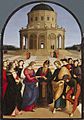
The ideal centrally planned urban space: Sposalizio by Raphael Sanzio, 1504
-
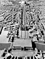
A 1939 model envisions Berlin transformed into the Welthauptstadt Germania (World Capital Germania).
-

the Seven Sisters in Moscow in the "Wedding Cake Style Buildings" with the "ring roads" in the city
-
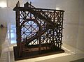
Model of the seismically protective wooden structure, the "gaiola pombalina" (pombaline cage), developed for the reconstruction of Pombaline Lower Town
-
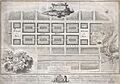
Craig's 1768 Plan for Edinburgh's New Town
-
Caernarvon (Wales). Plan by John Speed, 1611. Caernarfon castle and town were re-founded by King Edward I of England in July 1283.

.jpg)


_-_Geographicus_-_Edinburgh-craig-1768.jpg)

See also
- Index of urban planning articles
- Urban planning in Nazi Germany
- Urban planning in communist countries
