Itasca County, Minnesota facts for kids
Quick facts for kids
Itasca County
|
|
|---|---|

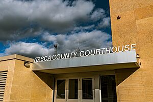
Itasca County Courthouse
|
|

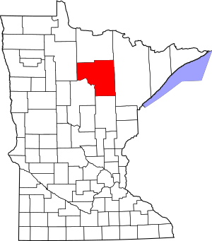
Location within the U.S. state of Minnesota
|
|
 Minnesota's location within the U.S. |
|
| Country | |
| State | |
| Founded | October 27, 1849 |
| Named for | Lake Itasca |
| Seat | Grand Rapids |
| Largest city | Grand Rapids |
| Area | |
| • Total | 2,928 sq mi (7,580 km2) |
| • Land | 2,668 sq mi (6,910 km2) |
| • Water | 260 sq mi (700 km2) 8.9%% |
| Population
(2020)
|
|
| • Total | 45,014 |
| • Estimate
(2023)
|
45,365 |
| • Density | 16.9/sq mi (6.5/km2) |
| Time zone | UTC−6 (Central) |
| • Summer (DST) | UTC−5 (CDT) |
| Congressional district | 8th |
Itasca County is a county in the Iron Range area of Minnesota. In 2020, about 45,014 people lived there. The main city and county seat is Grand Rapids.
The county gets its name from Lake Itasca. This lake's name comes from Latin words meaning 'truth' and 'head'. This refers to the lake being the true source of the Mississippi River. Parts of the Bois Forte and Leech Lake Indian reservations are also found in Itasca County.
Contents
History of Itasca County
Itasca County was first created in 1849. This happened when the Minnesota Territory was formed. The county was much larger back then. It covered many areas that are now separate counties in northeastern Minnesota.
The original Itasca County included parts of what are now Cook, Lake, Saint Louis, and Koochiching counties. It also stretched into eastern Lake of the Woods, eastern Beltrami, northern Aitkin, and northern Carlton counties.
The county was named after Lake Itasca. This lake was found to be the real starting point of the Mississippi River. For a long time, people argued about where the Mississippi River truly began. In 1832, Henry Schoolcraft went on a trip to find its source. When he found the lake, he named it 'Lake Itasca.' The Mississippi River starts small at Lake Itasca. You can even walk across it there. It then flows through Itasca County and continues all the way to the Gulf of Mexico.
Geography and Nature
Itasca County has a landscape with hills and many trees. It is also full of lakes and ponds. The land generally slopes towards the east. The highest points are on the western border. These areas are about 1,437 feet (438 meters) above sea level.
The county covers about 2,928 square miles (7,583 square kilometers). Most of this is land, about 2,668 square miles (6,910 square kilometers). The rest, about 260 square miles (673 square kilometers), is water. This means about 8.9% of the county is water. Itasca County is the third-largest county in Minnesota by land area.
The land in Itasca County is very diverse. You can find low plains, rolling hills, and wetlands. These features were shaped by glaciers long ago. The area is famous for its many forests. These forests have been here for hundreds of years. They are made up of different trees like pines, spruces, hardwoods, cedar, and tamarack. Because of these large forests, forestry and logging are very important jobs in the county.
Lakes and Rivers
Itasca County has many different bodies of water. These range from large lakes to small creeks and major rivers. There are over 1,400 lakes in the county. These waters help support many kinds of wildlife. You can find different birds and small mammals here.
Some of the major bodies of water in the county include:
- Lake Winnibigoshish
- Pokegama Lake
- Deer Lake
- The Mississippi River
- Bowstring Lake
- The Blandin Paper Mill Reservoir
Main Roads
Neighboring Counties
- Koochiching County - to the north
- Saint Louis County - to the east
- Aitkin County - to the south
- Cass County - to the southwest
- Beltrami County - to the west
Protected Natural Areas
Itasca County is home to several protected natural areas. These places help keep the environment healthy and safe.
- Big Fork State Forest
- Botany Bog Scientific and Natural Area
- Chippewa National Forest (part of it)
- George Washington State Forest (part of it)
- Golden Anniversary State Forest
- Marcell Experimental Forest
- Scenic State Park
People of Itasca County
| Historical population | |||
|---|---|---|---|
| Census | Pop. | %± | |
| 1850 | 97 | — | |
| 1860 | 51 | −47.4% | |
| 1870 | 96 | 88.2% | |
| 1880 | 124 | 29.2% | |
| 1890 | 743 | 499.2% | |
| 1900 | 4,573 | 515.5% | |
| 1910 | 17,208 | 276.3% | |
| 1920 | 23,876 | 38.7% | |
| 1930 | 27,224 | 14.0% | |
| 1940 | 32,996 | 21.2% | |
| 1950 | 33,321 | 1.0% | |
| 1960 | 38,006 | 14.1% | |
| 1970 | 35,530 | −6.5% | |
| 1980 | 43,069 | 21.2% | |
| 1990 | 40,863 | −5.1% | |
| 2000 | 43,992 | 7.7% | |
| 2010 | 45,058 | 2.4% | |
| 2020 | 45,014 | −0.1% | |
| 2023 (est.) | 45,365 | 0.7% | |
| U.S. Decennial Census 1790-1960 1900-1990 1990-2000 2010-2020 |
|||
Population in 2020
The 2020 Census showed the different groups of people living in Itasca County.
| Race | Number | Percent |
|---|---|---|
| White (not Hispanic) | 40,166 | 89.23% |
| Black or African American (not Hispanic) | 174 | 0.4% |
| Native American (not Hispanic) | 1,497 | 3.33% |
| Asian (not Hispanic) | 145 | 0.32% |
| Pacific Islander (not Hispanic) | 2 | 0.004% |
| Other/Mixed (not Hispanic) | 2,412 | 5.4% |
| Hispanic or Latino | 618 | 1.4% |
Cities and Towns
Itasca County has many communities. These include cities, census-designated places, and smaller unincorporated communities.
Cities in Itasca County
Census-Designated Places
These are areas that are like towns but are not officially incorporated as cities.
Unincorporated Communities
These are smaller settlements that do not have their own local government.
Townships
Townships are local government areas that cover rural parts of the county.
- Alvwood Township
- Arbo Township
- Ardenhurst Township
- Balsam Township
- Bearville Township
- Bigfork Township
- Blackberry Township
- Bowstring Township
- Carpenter Township
- Deer River Township
- Feeley Township
- Good Hope Township
- Goodland Township
- Grand Rapids Township
- Grattan Township
- Greenway Township
- Harris Township
- Iron Range Township
- Kinghurst Township
- Lake Jessie Township
- Lawrence Township
- Lone Pine Township
- Marcell Township
- Max Township
- Moose Park Township
- Morse Township
- Nashwauk Township
- Nore Township
- Oteneagen Township
- Pomroy Township
- Sago Township
- Sand Lake Township
- Spang Township
- Splithand Township
- Stokes Township
- Third River Township
- Trout Lake Township
- Wabana Township
- Wawina Township
- Wildwood Township
- Wirt Township
Unorganized Territories
These are areas that are not part of any city or township.
- Bowstring Lake
- Deer Lake
- Effie
- Liberty
- Little Sand Lake
- Northeast Itasca
Images for kids
See also
 In Spanish: Condado de Itasca para niños
 | DeHart Hubbard |
 | Wilma Rudolph |
 | Jesse Owens |
 | Jackie Joyner-Kersee |
 | Major Taylor |


