
Jefferson Davis Highway facts for kids
Quick facts for kids Jefferson Davis Highway |
|
|---|---|
| Jefferson Davis Memorial Highway | |
| Lua error in Module:Infobox_road/map at line 15: attempt to index field 'wikibase' (a nil value). | |
| Route information | |
| Existed | 1913–present |
| Major junctions | |
| East end | Arlington, Virginia |
| West end | San Diego, California |
| Location | |
| States: | Virginia, North Carolina, South Carolina, Georgia, Alabama, Mississippi, Louisiana, Texas, New Mexico, Arizona, California, Arkansas |
| Highway system | |
| Auto Trails
|
|

The Jefferson Davis Highway was a very long road planned in the United States in the early 1900s. It was meant to go all the way across the country. The road was named after Jefferson Davis. He was the president of the Confederate States of America during the American Civil War.
The highway was planned to start in Arlington, Virginia. From there, it would stretch south and west to San Diego, California. It is not fully clear if the entire road was ever built exactly as planned. This was due to some confusion between the groups building roads and the government.
Contents
History of the Highway
In the early 1900s, cars became very popular. Because of this, people wanted more roads. Private groups started building roads across the country. These roads were called auto trails. The government did not plan or help with these roads at first.
The first big auto trail was the Lincoln Highway. It was announced in 1912. Many other auto trails began in the next ten years. One of these was the Jefferson Davis Highway. It was sponsored by the United Daughters of the Confederacy (UDC). This group planned the road to go from Arlington, Virginia, through the southern states. It would end in San Diego, California. After more than ten years of planning, there was talk about extending the road even further north. It would go from San Diego to the Canada–US border.
When Auto Trails Ended

By the mid-1920s, the many different auto trails became confusing. So, the government decided to give numbers to highways. East-west roads got even numbers. North-south roads got odd numbers. Instead of one number for a whole auto trail, different parts of it got different numbers.
The UDC asked the government to give the Jefferson Davis Highway one single number. But the government was confused. They weren't sure which route the UDC was talking about. This is because the UDC had also named other smaller roads "Jefferson Davis Highway." These extra roads were meant to honor places important to Jefferson Davis's life. But they made it hard for the government to know the main route.
When numbered highways started, the Jefferson Davis Highway was split up. Parts of it became US Route 1, US 15, US 29, US 61, US 80, US 90, US 99, and US 190. Today, many of these numbered roads have also changed. They have been replaced by the Interstate Highway System.
Parts That Still Remain
Even though you can't see the whole highway on a map today, many parts of it still exist. They are scattered across the country. Here are some places where you can still find pieces of the Jefferson Davis Highway.
Virginia
In Virginia, parts of U.S. 1 are still called Jefferson Davis Highway. This includes sections in Prince William County and Caroline County. Also, a separate part from southern Richmond through Chesterfield County has this name.
The Virginia government officially named the Jefferson Davis Highway in Virginia in 1922. It was planned to go from Arlington to the North Carolina border. The original marker was near the 14th Street Bridge in Arlington. It was moved in the 1960s for safety.
Over the years, many parts of the highway in Virginia have been renamed. For example, Fairfax County changed its part to "Richmond Highway" around 1970. Alexandria and Arlington also renamed their sections to "Richmond Highway" in 2019. Prince William County approved the renaming in 2020.
Some older roads, like State Route 712 and U.S. Route 58, are still officially called Jefferson Davis Highway. Several markers along the highway in Virginia are listed on the National Register of Historic Places.

North Carolina
The Jefferson Davis Highway goes through North Carolina for about 162 miles. It follows US 15 to Sanford. Then it follows US 1 to the South Carolina border.
The state of North Carolina did not officially adopt this name for the highway. However, in Lee County, US 1 is officially called Jefferson Davis Highway. This was decided by the county in 1959. In 2020, the North Carolina Department of Transportation started removing Jefferson Davis highway signs. This happened after public discussions about the names of roads.
South Carolina
In South Carolina, the Jefferson Davis Highway is about 170 miles long. It follows US 1 from the North Carolina border to the Georgia border. You can find several monuments along this route. These include monuments in Camden and Aiken.
Georgia

You can still see highway markers in certain places in Georgia. These are along the old main route.
- In Taliaferro County, in Crawfordville along US 278.
- In Morgan County, in Madison along Main Street.
- In Walton County, also along US 278.
- In DeKalb County, between Atlanta and Decatur.
- In Coweta County, in Grantville, Georgia on Main Street.
An extra route through Georgia went south of the main route. It went through Irwin County and Irwinville. This is where Jefferson Davis was captured at the end of the Civil War. Today, SR 32 in this area is still officially named "Jefferson Davis Highway."
Alabama
In Alabama, a famous part of the Jefferson Davis Memorial Highway is US 80 from Selma to Montgomery. In 1965, Martin Luther King Jr. led marches on this road. These marches helped lead to the Voting Rights Act of 1965. This road also goes through eastern Montgomery and is now called the Atlanta Highway.
Mississippi
In Biloxi, there is a marker for the highway. It is located in front of "Beauvoir". This was the last home of Jefferson Davis. It is on the coastline, looking out over the Gulf of Mexico.
Texas
The main route in Texas went from the Sabine River to El Paso. This route mostly follows US 90 today. There was also a coastal branch from Houston to Brownsville. At least 18 markers still exist in Texas. The state transportation department did not officially name any state highways after Jefferson Davis. Several markers have been moved from public land.
New Mexico
Parts of I-10 were once signed as Jefferson Davis Highway. However, the state's Department of Transportation has removed these markers. Officials believe they have removed all remaining memorials to Jefferson Davis from rest areas along I-10 in New Mexico.
Arizona
In 1961, the Arizona State Government officially named the entire route of U.S. Route 80 in Arizona as the Jefferson Davis Highway. Some monuments with this name still remain along the old route. One example is a marker on U.S. Route 60 near Gold Canyon. Today, US 80 is no longer an active highway in Arizona. However, parts of it still exist as Arizona State Route 80 and Historic US 80.
California
The western end of the highway was marked by a monument in Horton Plaza in downtown San Diego. The formal opening of the highway at this end was done by President Warren Harding. Other markers exist in places like Bakersfield and Fort Tejon.
In 2017, the Jefferson Davis monument on Horton Plaza was removed. This happened after public protests and discussions. In 2020, a marker in Hornbrook was also removed by protestors.
Washington

In 1939, the Washington State Legislature suggested naming U.S. Route 99 the "Jefferson Davis Highway." This would have made it the final part of the highway. But this name was never made official.
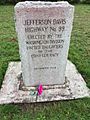
In 1998, officials in Vancouver removed a Jefferson Davis Highway marker. It was later moved to private land, Jefferson Davis Park, near Ridgefield. Another marker in Blaine, Washington was removed in 2002. This was because the highway was never officially named by the state to honor Davis. Both markers are now at the Jefferson Davis Park.
In 2016, the Washington State Legislature asked to rename what was left of old U.S. Route 99. They wanted to call it "William P. Stewart Memorial Highway." This would honor an African-American Civil War volunteer. The transportation commission agreed to this renaming in May 2016.
Images for kids
-
Jefferson Davis Highway Marker from Blaine Washington, now displayed at Jefferson Davis Park outside Ridgefield, Washington
