Oca River, Biscay facts for kids
Quick facts for kids Oca River |
|
|---|---|

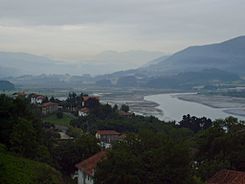
Marshland in the Oca estuary
|
|
| Physical characteristics | |
| River mouth | 43°21′21″N 02°40′17″W / 43.35583°N 2.67139°W |
| Length | 17 km |
The Oca River (in Basque: Oka) is a river in Spain. It flows through the region of Biscay in the Basque Country.
The area around the Oca River is very special. It is the main part of the Urdaibai Biosphere Reserve. UNESCO made it a protected area in 1984. This place is super important for nature, especially for birds!
Because of its amazing birdlife, it became a Special Protection Area for Birds (SPA) in 1994. It also joined the Natura 2000 Network. In 1992, it was added to a list of important wetlands by the Ramsar Convention.
There are other rivers with a similar name. In Spain, there's another Oca River in the province of Burgos. It flows into the Ebro river. In Russia, there's an Oká River that flows into the Volga.
Contents
Where the Oca River Flows
The Oca River starts where several small streams meet. These streams come from mountains like Goroño (601 m high), Oiz (1035 m high), Bizkargi (563 m high), and Arburu (552 m high). This meeting point is in a place called Zugastieta.
The river then flows from south to north. It ends up in the Urdaibai estuary. The Oca River is 17 kilometers (about 10.5 miles) long.
The Oca River passes through many towns. These include Mundaka, Sukarrieta, Busturia, Murueta, Forua, Guernica and Lumo, Ajangiz, Mendata, Arratzu, Kortezubi, Gautegiz Arteaga, Muxika, and Ibarranguelu.
The Oca River Basin
The Oca River basin covers an area of 132 square kilometers (about 51 square miles). The river itself is 17 kilometers long. At the start, many small streams flow down from the mountains. They join together at Zugastieta to form the main river.
These streams flow through narrow, steep valleys. These valleys are covered with riparian forests. These are forests that grow along riverbanks. There are also many Monterey pine plantations. The slopes on the east side of the valley can be very steep. From Zugastieta, the Oca River flows over a stony riverbed. It forms many rapids and waterfalls.
A few kilometers before the town of Guernica, the land becomes flat. The riverbed starts to curve a lot. From Guernica, the river becomes a Ria. This means the ocean's tide reaches this far inland. Guernica used to have a river port. Boats from the port of Mundaca, at the mouth of the estuary, would come here. These boats were called "merchant nadichuelos." The port was the main reason Guernica was founded. Its old town charter said:
Let all those who see this proivilege letter know that I, Don Tello, with the pleasure of all the people of Biscay, have made in Guernica the town and village that is called Puerto de Guernica.../ "... I command that you shall not owe any duty or thirty percent or price for any ship or Bagel, or any other merchandise, that comes or goes from this place of Guernica."
Before Guernica, the Oca River gets water from the Ugarte stream. This stream is also called Múgica. It flows from the Vizcargui mountains. After Guernica, the Oca's main tributary joins it. This is the Berrekondo river, which comes from the Oiz mountains. Near San Cristóbal island, the Mape stream joins the Oca. It comes from the Sollube mountain.
Much of the land on the right side of the basin is made of limestone. This forms a karstic system. This means that surface water is rare. Rivers in this area often flow underground for some parts. The Oma river is an example of this.
As the river gets closer to the sea, the land changes. The river drops sediments, which are bits of dirt and rock. This can make the riverbed get clogged. In the estuary, the amount of water from the tide is much more than from the river. The waters mix completely.
The sediments from the river are carried upstream by the tides. They form a gently sloping plain. Cretaceous limestone and Triassic ophites stick out from the sand. They make the valley narrow in some places.
In the early 20th century, a straight channel was built. It went from Guernica to Murueta. This channel is 5 kilometers long and is called Corte de la Ría. It cut off the old, winding river path. The old curves became unusable and filled up. Some of the marshlands on both sides of the channel were drained. This was done using structures called munas or polders. The reclaimed land was then used for farming or for animals to graze. These fields are often a safe place for birds in winter.
Near the sea, the river's mud turns into sand. On the right side is the big sandy area of Laida. On the left side is the fishing village of Mundaca.
At the mouth of the estuary is Izaro Island. It forms a small group of islands with Hotzarri and Potorro-harri. Izaro used to be connected to the mainland. Now, a sandy channel separates it.
How Land is Used in the Basin
The land in the Oca basin is mostly used for agriculture (farming) and forestry (growing trees). In the upper parts, most land is used for growing pine and eucalyptus trees. These trees are cut down for wood. In the lower parts, the land is used for farming and raising livestock.
The areas around towns have services for people and different industries. These include metalworking, shipbuilding, chemical factories, and canning factories.
The entire Oca basin is protected as the Urdaibai Biosphere Reserve. This means how the land is used is guided by a special plan. This plan helps protect the natural and cultural heritage of the area. It also helps people live and work in a way that doesn't harm the environment. The plan aims to protect and bring back all the natural systems. It focuses on water and native plants. It also encourages smart ways to use the rural land.
Plants and Animals of the Oca River
Plants (Flora)
The plants in Urdaibai are typical of the Atlantic region. You can find many meadows, oak groves, and thick forests. There are also many plantations of fast-growing conifers like Pinus radiata. The coastal area has Cantabrian forests with holm oaks and Arbutus trees.
This area is home to 615 different plant species. These plants support a rich animal world. There are 318 types of vertebrate animals, and 245 of them are birds!
The types of plants depend on the environment. Things like how salty the water is, the type of soil, and the direction the land faces all play a role. In the upper parts of the basin, you can still find Atlantic forests. These have chestnut, oak, and ash trees. Along the riverbanks, there are alder trees, along with oak, ash, maple, and elm trees. You can also see willows.
The marshlands have grassy and bushy plants that like rich soil. In areas with a lot of saltwater, zostera plants grow in the sand or sandy mud. These areas are covered by water at high tide. Where the soil is muddy and has a lot of organic matter, maritime spartina grows. When the area is rarely flooded by the tide, juncus and sea rushes appear. If the water is less salty, elymus meadows grow.
Most of the middle parts of the basin are Atlantic countryside. This area has been changed by humans. It was used for farming and raising livestock by people living in baserri (traditional Basque farmhouses). This area is very rich in nature. It has a mix of crops, meadows, heathlands, and forests. However, some of this area is changing. People are leaving farms, and pine trees are being planted instead.
Animals (Fauna)
You can see many types of fish and amphibians in the Oca River and its smaller streams. The fish change depending on where you are in the river. In the upper parts, you'll find trout, loach, eel, and escalo. In the middle parts, you'll also see barbel and carp. These become more common closer to the river's mouth. In the estuary, you'll find saltwater fish like corcón, flounder, and eel.
Amphibians are sensitive to their environment. You can find salamanders, marbled newts, toads, common frogs, European tree frogs, Iberian frogs, and tridactyl skinks.
There are also many important mammals, both big and small. The European mink is very special because it is in danger of disappearing. Other protected animals include the dormouse, polecat, and wild cat. You might also see rabbits, genets, martens, water shrews, wild boar, and roe deer. Sometimes, you might even spot an American mink that has escaped from a farm.
Birds (Birdlife)
The most important animals in this area are birds. This is why the area was protected! The reserve is right in the middle of a major bird migration route. Its marshes are a perfect place for many birds to stop, rest, and eat. These birds travel between Europe and Africa. Besides being a resting spot, many birds also use the reserve for nesting.
Since 2009, the Urdaibai Bird Center has been studying the birds here. It's a well-known bird center in Europe. They study how birds use their habitats, their migration, their life cycles, and how their populations change. They also use scientific banding to learn more about different bird species.
The latest bird report from the Urdaibai Bird Center lists many common birds. These include the grey heron, spoonbill, osprey, bittern, black-winged stilt, greenshank, little grebe, great egret, wigeons, Hobby, aquatic warbler, and kingfisher. You can see them at different times of the year. Urdaibai also has rare birds for Spanish wetlands. These include the brant, common eider, velvet scoter, or long-tailed duck. The numbers of barnacle goose and whooper swan also go up in winter.
Oca River Tributaries
The Oca River has several smaller rivers and streams that flow into it.
Rivers Joining from the Right Side
- Berrekondo
- Golako
- Oma River
Rivers Joining from the Left Side
- Ugarte or Múgica
- Busturia
- Sollube
The Golako River
The Golako River has very good water quality. This is shown by the many different small water creatures that live in it. It flows through beautiful landscapes with lots of trees. It also has many different river ecosystems.
Along its banks, you can find old mills and forges. Forges were places where metal was shaped. The dam of one of these, Uharka, now powers a small hydroelectric plant.
The Oma River
The Oma River flows through the valleys of Basondo and Oma. It runs under the limestone mountain of Ereñozar. Because the land is made of limestone, it has a karstic system. This means you can see many sinkholes (holes in the ground) and lots of caves. The limestone land is also perfect for Cantabrian holm oak forests. This area has one of the most important holm oak forests in Biscay. You can still see the remains of an old mill here.
See also
 In Spanish: Río Oca (Vizcaya) para niños
- Busturialdea
- Urdaibai estuary
 | Georgia Louise Harris Brown |
 | Julian Abele |
 | Norma Merrick Sklarek |
 | William Sidney Pittman |


