State cessions facts for kids
The state cessions are areas of land in the United States that individual states gave up to the federal government in the late 1700s and early 1800s. Most of this land was located between the Appalachian Mountains and the Mississippi River. Giving up these lands was very important for creating a strong and peaceful union among the original British colonies.
These ceded areas cover about 236,825,600 acres (958,390 km²), which is about 10.4 percent of the current United States territory. This land now makes up all or part of 10 states. This amount does not include land that Texas later gave up to the federal government, which became parts of five more states.
Contents
Why States Gave Up Land Claims
Most of the British colonies in North America were started in the 1600s and early 1700s. Back then, people didn't know much about the geography of North America. Many colonies were given land by the King of England, with their borders stretching "from sea to sea" across the continent. Other colonies didn't have any western borders at all!
This led to a big problem: many colonies claimed the same land, and their claims often overlapped with areas claimed by other European countries. The British government tried to slow down people moving into these western lands with the Royal Proclamation of 1763. However, many people ignored this rule and continued to settle new areas.
By the time of the American Revolution, the borders between the Thirteen Colonies were mostly set. But their claims to land in the west were very different. For example, Kentucky was actually part of Virginia and governed by Virginia until it became a separate state in 1792. On the other hand, Massachusetts claimed land in what is now Michigan and Wisconsin, but this was mostly just lines on a map.
After the French and Indian War ended in 1763 with the Treaty of Paris (1763), France gave up most of its land claims in North America to Great Britain and Spain. Great Britain gained the eastern half of France's southern lands. This allowed Great Britain to extend the claims of its colonies like Massachusetts, Connecticut, Virginia, North Carolina, South Carolina, and Georgia all the way to the Mississippi River.
How the Land Claims Were Solved
The Treaty of Paris (1783), which ended the American Revolution, gave the new United States control over the land between the Appalachian Mountains and the Mississippi River. One of the first big challenges for the new nation was figuring out how to govern this land and how to solve the conflicting claims from several states.
There were two main problems. First, many states claimed the same piece of land. Clearly, only one state could truly own it. Second, only seven of the thirteen states had these large western land claims. The other "landless" states were worried that the states with huge territories would become too powerful. Virginia, for example, already had one in five people in the new nation and claimed modern-day Kentucky and a huge area called Illinois County. Smaller states feared Virginia would completely control the new union.
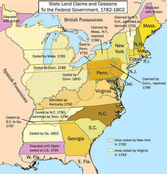
Most of the land claims west of the Appalachians were given to the federal government between 1781 and 1787. New York, New Hampshire, and Vermont settled their disagreements by 1791. Kentucky separated from Virginia and became a new state in 1792.
These land cessions weren't always completely selfless. Sometimes, states gave up land in exchange for the federal government paying off their debts from the Revolutionary War. But the states' willingness to give up their conflicting claims prevented serious problems among the young states. It also helped convince the "landless" states to agree to the new United States Constitution. These cessions also paved the way for settling the Upper Midwest and for the U.S. to expand across North America. It also set a pattern: newly acquired land would become new states, not just added to old ones.
Georgia held onto its claims over western land for another ten years. This claim was tricky because much of the land was also disputed between the United States and Spain. When Georgia finally sold the land west of its current borders to the United States for cash in 1802, the last part of these western land cessions was finished.
Details of the Land Cessions
States with Western Land Claims
| State | Date Ceded | Date Accepted | Claims and What Happened |
|---|---|---|---|
| May 11, 1786 | May 28, 1786 | Connecticut claimed a strip of land from its northern and southern borders, stretching west to the Mississippi River. This land crossed parts of present-day Pennsylvania, Ohio, Michigan, Indiana, and Illinois. It kept a small part south of Lake Erie, known as the "Connecticut Western Reserve", but gave up control of this area to the federal government in 1800. | |
| April 24, 1802 | June 16, 1802 | Georgia gave up the "Yazoo lands", which were between the 35th parallel and 31st parallel of latitude, stretching west to the Mississippi River. This land is now part of Alabama and Mississippi. Georgia was unique because it charged the federal government $1.25 million for this land, and the government paid it. | |
| November 13, 1784 | April 19, 1785 | Massachusetts claimed a strip of land stretching west from its northern and southern borders. This claim crossed parts of present-day New York, Michigan, and Wisconsin. It was based on its original "sea-to-sea" grant from the British Crown. | |
| February 19, 1780 | October 29, 1782 | New York gave up its claims to land west of Lake Ontario. New York was allowed to keep some land west of the Preemption Line in 1786, which became Western New York. A small part of this, the Erie Triangle, was sold to Pennsylvania in 1792. | |
| December 22, 1789 | February 25, 1790 | North Carolina gave up its land west of the Appalachians, known as the Washington District. This land, a strip between its northern and southern borders stretching west to the Mississippi River, became the Southwest Territory and later the State of Tennessee. | |
| March 8, 1787 | August 9, 1787 | South Carolina gave up a strip of land, about 12 km (7.5 mi) wide, stretching west from its northwestern tip to the Mississippi River. This land crossed extreme southwest North Carolina, northern Georgia, and the southern edge of present-day Tennessee, along with the northern edge of present-day Alabama and Mississippi. South Carolina and Georgia also adjusted their shared border. | |
| January 2, 1781 | March 1, 1784 | Virginia gave up its huge claim to the land north of the Ohio River, which later became the Northwest Territory. However, it kept its other western claim, the Kentucky County, south of the Ohio and east of the Mississippi River (present-day Kentucky). Virginia also gave land to the federal government that became part of Washington, D.C.; this land was later given back to Virginia. |
States Without Western Land Claims
| State | Notes |
|---|---|
| Delaware did not claim any land further west. Its western border is part of the Mason–Dixon line. | |
| Maryland did not claim land further west, but it gave land to the federal government that became part of Washington, D.C. (and is now all of it). Maryland's northern border is also part of the Mason–Dixon line. | |
| Before the American Revolution, New Hampshire claimed land west of the Connecticut River in what is now southern Vermont. This land was also claimed by New York. This dispute led to the creation of the Vermont Republic. New Hampshire's claim was ended in 1764 by a royal order. In 1790, New York gave up its land claim to Vermont for 30,000 dollars. | |
| New Jersey did not claim any land further west. | |
| Pennsylvania's original land grant from King Charles II of England was for land between the 42nd parallel and the 38th parallel in latitude, extending west five degrees in longitude from New Jersey's western border. Its southern border is part of the Mason–Dixon line.
Pennsylvania claimed the land along Lake Erie, known as the Erie Triangle. After Massachusetts and New York gave up their claims to it, the federal government sold the triangle to Pennsylvania in 1788. |
|
| Rhode Island did not claim any land further west. |
Texas's Land Cession

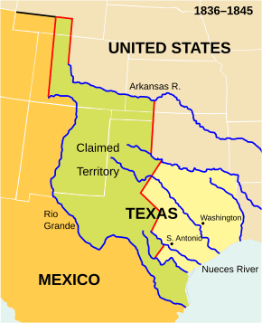
Later in the 1800s, there was another case of a state giving up some of its land. Before the Republic of Texas joined the United States in 1845, it claimed a lot of land that its government had never actually controlled. Texas's attempts to control these areas, like the Santa Fe expedition, had failed.
Because of this, there was a border dispute between Texas, Mexico, and Native American tribes. The U.S. government took on this problem when Texas joined the United States. This dispute was one of the reasons for the Mexican–American War in 1846–47. After the U.S. won the war, the Mexican government recognized American control over the disputed Texan lands and also sold other land stretching west to the Pacific Ocean. Mexico was paid $25,000,000 under the Treaty of Guadalupe Hidalgo in 1848.
The large land claims of the Republic of Texas did not become the final northern and western borders of the State of Texas. Most of its northern border had already been set by a treaty between the United States and the Spanish Empire along the Red River.
In 1850, as part of a law called the Compromise of 1850, Texas gave up its conflicting northern and western land claims to the U.S. In return, the U.S. helped Texas with its debts. This land that Texas gave up eventually became parts of the states of Kansas (1861), Colorado (1876), Wyoming (1890), Oklahoma (1907), and New Mexico (1912).
 | Roy Wilkins |
 | John Lewis |
 | Linda Carol Brown |


