Plate tectonics facts for kids
Plate tectonics is a scientific idea that explains how Earth's outer layer, called the lithosphere, is made of huge pieces called tectonic plates. These plates have been slowly moving for billions of years. This idea grew from an older concept called continental drift, which suggested that continents once moved across the Earth. Scientists accepted plate tectonics in the 1960s after they found strong evidence for seafloor spreading.
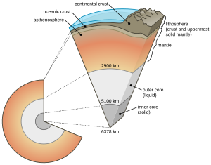
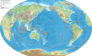
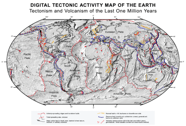
Earth's lithosphere is its rigid, rocky outer shell. It includes the crust and the top part of the upper mantle. This shell is broken into about seven or eight large plates and many smaller ones. Where these plates meet, their movement creates different types of plate boundaries: where they pull apart (divergent), push together (convergent), or slide past each other (transform). Plates usually move from zero to 10 centimeters (about 4 inches) each year. These plate boundaries are often active with earthquakes, volcanic activity, mountain-building, and the formation of deep oceanic trenches.
Tectonic plates are made of two types of crust: oceanic crust (under the oceans) and continental crust (under the land). At convergent plate boundaries, one plate can slide under another in a process called subduction. This makes the Earth's surface area smaller in that spot. But new oceanic crust is always forming at divergent boundaries through seafloor spreading. This keeps the total surface area of Earth constant, like a giant conveyor belt.
These plates are stiff and float on a softer, flowing layer beneath them called the asthenosphere. Heat moving around in the mantle below causes slow currents, which help move the plates. Where new crust forms at a mid-ocean ridge, plates move away from the ridge. This new crust cools and gets heavier as it moves, which also helps it slide. At a subduction zone, the cold, heavy oceanic crust sinks into the mantle, pulling the rest of the plate along. This "slab pull" is the strongest force driving plate motion.
How Earth's Layers Move
Earth's outer layers are divided into the lithosphere and the asthenosphere. This division is based on how they behave. The lithosphere is cooler and stiff, while the asthenosphere is hotter and can flow slowly. The lithosphere loses heat by simply passing it through, but the asthenosphere also moves heat by currents, like boiling water. It's important not to confuse this with the chemical layers of Earth, like the crust and mantle. A piece of the mantle can be part of either the lithosphere or the asthenosphere, depending on its temperature and pressure.
The main idea of plate tectonics is that the lithosphere is broken into separate plates. These plates float on the fluid-like solid asthenosphere. Plates move at different speeds. For example, the Mid-Atlantic Ridge moves about 10 to 40 millimeters (0.4 to 1.6 inches) per year, which is about as fast as your fingernails grow. The Nazca Plate moves faster, about 160 millimeters (6.3 inches) per year, similar to how fast hair grows.
Tectonic plates have two types of crust: oceanic crust and continental crust. Oceanic crust forms at places where the seafloor spreads apart. Continental crust forms from volcanoes and by pieces of land joining together. Oceanic crust is heavier than continental crust. Because of this, oceanic crust usually sits below sea level, while continental crust floats higher, forming continents.
Typical oceanic lithosphere is about 100 kilometers (62 miles) thick. It gets thicker as it gets older and moves away from where it formed. This is because it cools down and more mantle material sticks to its bottom. Continental lithosphere is usually about 200 kilometers (124 miles) thick, but this can change a lot depending on the area.
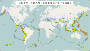
The place where two plates meet is called a plate boundary. Most earthquakes and the creation of features like mountains, volcanoes, mid-ocean ridges, and oceanic trenches happen at these boundaries. Most active volcanoes are found along plate boundaries, especially the Pacific Ring of Fire around the Pacific Plate. Some volcanoes also appear in the middle of plates, possibly due to hot spots from deep within the mantle.
Tectonic plates can include both continental and oceanic crust. For example, the African Plate includes the continent of Africa and parts of the Atlantic and Indian seafloors.
Types of Plate Boundaries
There are three main types of plate boundaries, named after how the plates move relative to each other. Each type creates different features on Earth's surface.
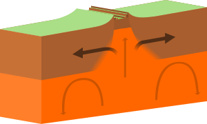
- Divergent Boundaries: These are places where two plates pull apart from each other.
- When oceans rift (split), new seafloor forms, creating new ocean basins. Examples include the Mid-Atlantic Ridge. As the ocean plate splits, a ridge forms, the ocean basin gets wider, and new crust is made. This causes many small volcanoes and shallow earthquakes.
- When continents rift, new ocean basins can form as the continent splits. An example is the East African Rift.
- Convergent Boundaries: These are where two plates push toward each other. This can lead to one plate sliding under the other (subduction) or two plates crashing together (continental collision).
- Subduction Zones:
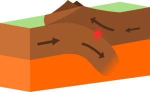
- Ocean-to-Continent Subduction: The heavier oceanic plate slides under the lighter continental plate. This forms deep ocean trenches and mountain ranges with volcanoes, like the Andes Mountains. As the sinking plate heats up, it releases water, which lowers the melting point of the mantle above it. This creates magma that rises to form volcanoes.
- Ocean-to-Ocean Subduction: An older, colder, and heavier oceanic plate slides under a younger, lighter oceanic plate. This forms deep trenches and chains of volcanic islands in an arc shape, like the Aleutian Islands or the Japanese island arc.
- Continental Collision Zones: When two continental plates crash, neither plate can easily slide under the other because they are both relatively light. Instead, their edges get squeezed, folded, and pushed up, forming huge mountain ranges like the Himalayas and the Alps.
- Subduction Zones:
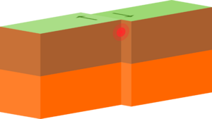
- Transform Boundaries: At these boundaries, plates slide past each other. No new crust is made, and no old crust is destroyed. Instead, the plates grind past each other along transform faults. This movement can be either left-sided or right-sided. Strong earthquakes can happen along these faults. The San Andreas Fault in California is a famous example of a transform boundary.
- Plate Boundary Zones: Sometimes, the way plates interact is not clear, and the boundaries are wide areas with different types of movements happening at different times.
Why Plates Move
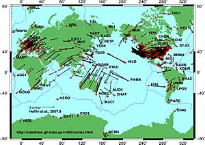
Tectonic plates can move because the oceanic lithosphere is dense, and the asthenosphere beneath it is weak. The original energy for plate tectonics comes from Earth's internal heat, which creates slow currents in the mantle. A major force driving plate motion is the weight of the dense oceanic lithosphere sinking at subduction zones. When new crust forms at mid-ocean ridges, it's less dense than the asthenosphere below. But as it cools and thickens with age, it becomes denser. This heavier, older lithosphere then sinks into the deep mantle at subduction zones, providing most of the power for plate movement. The weak asthenosphere allows the plates to slide easily.
Forces from Inside Earth
For a long time, scientists thought that large currents in the upper mantle were the main force moving tectonic plates. This idea was first suggested by Arthur Holmes in the 1930s. It helped explain how continents could move, an idea first proposed by Alfred Wegener.
New ways to see inside Earth, like seismic tomography, show that the mantle has different densities. These density differences cause the mantle to slowly move in currents, like a very thick, slow-moving liquid. This process is called mantle convection.
Scientists are still studying exactly how mantle convection directly and indirectly moves plates. One idea is that the convection currents in the asthenosphere drag the plates along. Another important idea is "slab pull," where the sinking of a plate at a subduction zone pulls the rest of the plate with it. When a plate dives into the mantle, it can also create a suction force that pulls the plate forward.
Forces from Gravity
Gravity also plays a big role in plate motion, especially through "slab pull" at subduction zones.
Another force is "gravitational sliding" away from a spreading ridge. As new oceanic lithosphere forms at mid-ocean ridges, it's hot and sits higher. As it moves away, it cools and gets heavier, slowly sinking. This creates a slight slope away from the ridge. The plate then slides down this gentle slope due to gravity. This force is sometimes called "ridge push," but it's more like a gravitational slide.
Slab pull is currently thought to be the strongest force acting on plates. It's the weight of the cold, dense plates sinking into the mantle at trenches that pulls the rest of the plate along. However, some plates, like the North American Plate, are moving even though they are not being subducted. This shows that other forces are also at work.
Forces from Earth's Rotation
Alfred Wegener first thought that forces from tides and Earth's spin might move continents. However, these forces were considered too small. But with the modern understanding of plate tectonics, these ideas are being looked at again.
Some scientists suggest that the Moon's gravity pulling on Earth's crust (tidal drag) could cause a slight westward movement of the lithosphere. This might explain why Venus and Mars don't have plate tectonics, as Venus has no moon and Mars' moons are very small. However, other studies show that many plates move north and eastward, and the westward motion of the Pacific Ocean is mainly due to its spreading center. The debate about the role of Earth's rotation and the Moon in plate tectonics is still ongoing.
Which Force is Most Important?
The movement of a plate is a result of all the forces acting on it. It's hard to say exactly how much each force contributes to the overall motion of every plate.
One important observation is that plates connected to sinking (subducting) plates move much faster than other plates. For example, the Pacific Plate is mostly surrounded by subduction zones (the "Ring of Fire") and moves very quickly. Plates in the Atlantic basin, which are attached to continents instead of subducting plates, move slower. This suggests that forces from the sinking plate (slab pull and slab suction) are the main drivers for plates that are being subducted. However, recent studies suggest that mantle convection currents spreading horizontally beneath plates might also be very important. The exact driving forces of plate motion are still a big area of research in Earth science.
How the Theory Developed
The theory of plate tectonics developed over about 50 years of scientific discussion. It was a huge change in how scientists understood Earth, often called a "scientific revolution."
Around the early 1900s, scientists tried to explain why continents looked like they fit together and why similar plants, animals, and rocks were found on different continents. In 1912, a meteorologist named Alfred Wegener proposed the idea of continental drift. He suggested that all the continents were once joined in a single supercontinent, which he called Pangaea. Then, they slowly broke apart and drifted to their current positions. He compared them to "icebergs" floating on a denser layer.
Wegener found evidence for his idea:
- The coastlines of South America and Africa seemed to fit together like puzzle pieces.
- Similar rock formations were found along these matching coastlines.
- Fossils of the same ancient plants (like Glossopteris) and animals (like Lystrosaurus) were found on continents now separated by vast oceans, including South America, Africa, Antarctica, India, and Australia.
However, many scientists didn't accept Wegener's ideas at first. The main reason was that he couldn't explain how the continents moved. They couldn't imagine how solid continental rock could plow through the much denser oceanic crust.
Floating Continents and Earthquakes
Early in the 20th century, scientists thought there were two types of crust: "sial" (continental, like granite) and "sima" (oceanic, like basalt). They also thought the crust was fixed. But observations showed that mountains had "roots" that extended deeper into the Earth, suggesting they floated on a denser layer.
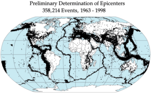
As seismographs improved, scientists learned that earthquakes happen in specific areas, especially along deep oceanic trenches and spreading ridges. By the late 1920s, seismologists like Kiyoo Wadati and Hugo Benioff identified earthquake zones that sloped down into Earth. These are now called Wadati–Benioff zones. Better data in the 1960s allowed scientists to map these earthquake zones precisely around the world.
Another piece of evidence came from paleomagnetism, the study of Earth's past magnetic field. Rocks of different ages showed different magnetic field directions. Scientists initially thought the magnetic poles had moved ("polar wander"). But then they realized that the continents themselves might have moved and rotated relative to the poles. In the 1950s, scientists like Keith Runcorn and Samuel Warren Carey showed that this magnetic evidence supported continental drift.
Seafloor Spreading
In 1947, scientists found that the central Atlantic Ocean had a rise, and the seafloor was made of basalt, not granite. They also found that oceanic crust was much thinner than continental crust. These discoveries raised big questions.
New maps of the ocean floor showed a system of mid-oceanic ridges all over the globe. Scientists realized that new ocean floor was being created along these ridges. This led to the idea of the "Great Global Rift" described by Bruce C. Heezen in 1960. If new crust was constantly being made, how was Earth not getting bigger?
The answer came from scientists like Arthur Holmes and Harry Hammond Hess. They suggested that the excess crust disappeared along oceanic trenches, where "subduction" occurred. Hess, a geologist, and Robert S. Dietz, who coined the term seafloor spreading, put these ideas together. They reasoned that new oceanic crust continuously spreads away from the ridges like a conveyor belt. Millions of years later, this crust sinks back into the mantle at oceanic trenches, especially around the Pacific Ring of Fire. New magma then rises at the spreading ridges to form new crust. This means ocean basins are constantly being "recycled." This idea explained why Earth doesn't get bigger, why there's little sediment on the ocean floor, and why oceanic rocks are much younger than continental rocks.
Magnetic Stripes
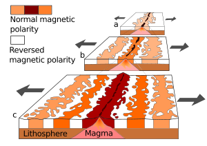
In the 1950s, scientists found strange magnetic variations across the ocean floor using magnetometers. They knew that basalt, the rock making up the ocean floor, contains magnetic minerals. As more of the seafloor was mapped, these magnetic variations formed a "zebra-like" pattern: stripes of normal magnetic polarity next to stripes of reversed polarity. This pattern was published by Ron G. Mason in 1961.
Scientists like Heezen, Hess, and Dietz had already theorized that mid-ocean ridges were weak zones where new magma rose to create new oceanic crust. In 1963, Lawrence Morley, and Fred Vine and Drummond Matthews, independently linked the magnetic striping to seafloor spreading and Earth's magnetic field reversals.
Their hypothesis was supported by several facts:
- The magnetic stripes were symmetrical around the mid-ocean ridges.
- Rocks at the ridge crest were very young and had normal magnetic polarity.
- Rocks got progressively older farther away from the ridge.
- The stripes alternated in magnetic polarity (normal-reversed-normal), matching the known history of Earth's magnetic field reversals.
By explaining both the magnetic stripes and the mid-ocean ridge system, the seafloor spreading idea quickly gained support. It showed that the oceanic crust acts like a "tape recorder" of Earth's magnetic field history.
The Theory Takes Shape
With all this evidence, plate tectonics (first called "New Global Tectonics") was quickly accepted. Many papers followed, defining the concepts:
- In 1965, John Tuzo Wilson added the idea of transform faults, which are needed for plates to move smoothly around the globe.
- A major meeting in London in 1965 is seen as the official start of plate tectonics' acceptance. Here, Edward Bullard and others showed how the continents around the Atlantic could fit together perfectly using computer calculations.
- In 1967, W. Jason Morgan suggested that Earth's surface has 12 rigid plates moving relative to each other.
- Soon after, Xavier Le Pichon published a complete model with six major plates and their movements, which sealed the theory's acceptance.
- Since then, scientists have focused on understanding the forces that drive plate tectonics, moving from just describing movement to understanding why it happens.
Plate Movement and Life
Continental drift helps scientists explain why similar plants and animals are found on different continents today, even though they are separated by oceans. For example, it explains the distribution of flightless birds like ratites and certain ancient plants across the southern continents, which were once part of the supercontinent Gondwana.
Reconstructing Past Plates
Scientists use plate reconstruction to figure out how continents and oceans looked in the past, and even how they might look in the future. This helps us understand ancient supercontinents and the geography of the past.
Finding Old Plate Boundaries
Today's plate boundaries are found by looking at where earthquakes happen. Past plate boundaries within existing plates are identified by clues like ophiolites, which are pieces of ancient oceanic crust found on land, showing where old oceans used to be.
How Plates Moved in the Past
Plate motion is thought to have started about 3 to 3.8 billion years ago. Scientists use different types of information to understand past plate movements:
- Continent Fit: How well continents, like West Africa and South America, fit together.
- Magnetic Stripes: Patterns of magnetic stripes on the seafloor give reliable clues about plate movements going back to the Jurassic period (about 200 million years ago).
- Hotspot Tracks: These show the absolute movement of plates, but only go back to the Cretaceous period (about 145 million years ago).
- Paleomagnetic Poles: Data from ancient magnetic poles helps figure out the latitude and rotation of continents in the past.
- Rock and Fossil Distribution: Where certain types of rocks and fossils are found can also show how continents were once connected.
Continents Forming and Breaking Up
The movement of plates has caused continents to form and break apart over Earth's history. Sometimes, almost all the continents come together to form a supercontinent.
- The supercontinent Columbia formed about 2 to 1.8 billion years ago and broke up around 1.5 to 1.3 billion years ago.
- Rodinia formed about 1 billion years ago and broke into eight continents around 600 million years ago.
- These eight continents later re-assembled into another supercontinent called Pangaea. Pangaea then broke into Laurasia (which became North America and Eurasia) and Gondwana (which became the other continents).
The Himalayas, the world's tallest mountain range, formed when two major plates collided. Before they rose, the area was covered by the Tethys Ocean.
Today's Plates
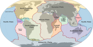
There are usually seven or eight "major" plates: the African, Antarctic, Eurasian, North American, South American, Pacific, and Indo-Australian. The Indo-Australian plate is sometimes split into the Indian and Australian plates.
There are also dozens of smaller plates. The eight largest of these are the Arabian, Caribbean, Juan de Fuca, Cocos, Nazca, Philippine Sea, Scotia and Somali.
Today, scientists use satellites to measure the exact movement of tectonic plates.
Plates on Other Planets
Whether other planets have plate tectonics seems to depend on their size. Planets bigger than Earth might be more likely to have it. Earth might be a special case because it has a lot of water, which helps its plates move.
Venus
Venus doesn't show signs of active plate tectonics today. There's some debate about whether it had it in the distant past. Most scientists think Venus had a huge volcanic event that resurfaced its entire planet hundreds of millions of years ago. One reason Venus might not have plate tectonics is that it's too hot for much water to be present. Water helps create weak zones in Earth's crust that allow plates to move.
Mars
Mars is much smaller than Earth and Venus. While there's evidence of ice, scientists disagree if Mars ever had plate tectonics. Some features, like Valles Marineris, might be old tectonic boundaries. In 1999, the Mars Global Surveyor spacecraft found magnetic striping on Mars, which some scientists thought meant plate tectonics. However, this data didn't pass a "magnetic reversal test," so it's not clear if it was caused by plate tectonics.
Icy Moons
Some of Jupiter's moons, like Europa, show signs of plate-tectonic-like activity, even though they are made of ice, not rock. In 2014, NASA reported finding evidence of subduction on Europa, which would be the first sign of such activity on another world besides Earth. Titan, Saturn's largest moon, also showed signs of tectonic activity in images from the Huygens probe.
Exoplanets
For Earth-sized planets outside our solar system, plate tectonics is more likely if they have oceans of water. However, some studies suggest that larger "super-Earths" might have plate tectonics even if they are dry. Thinking about plate tectonics on other planets is part of the search for alien life.
Images for kids
See also
 In Spanish: Tectónica de placas para niños
- Atmospheric circulation
- Conservation of angular momentum
- Geological history of Earth
- Geodynamics
- Geosyncline
- GPlates
- Outline of plate tectonics
- List of submarine topographical features
- Supercontinent cycle
- Tectonics


