
Transportation in Omaha facts for kids

Transportation in Omaha, Nebraska includes many ways to get around, like walking, biking, driving cars, riding buses, taking trains, and flying airplanes. In the past, people used ferries, stagecoaches, steamboats, and streetcars. Today, Omaha has modern highways, beautiful boulevards, and many trails for bikes and walkers. Omaha was once called the "Gate City of the West" because it was a key hub for early settlers heading west and the start of the First transcontinental railroad.
When Omaha was a new city, it was a busy place. Many warehouses were built for settlers to get supplies before traveling further west. Riverboats and stagecoaches brought all kinds of people to the city. Omaha also became the home of the Union Pacific Railroad, which made it very important for trains across the country.
As Omaha grew, its streets were not always paved well. Horse-drawn streetcars were popular, but there were only a few miles of cable car lines. Some early neighborhoods like Dundee and Benson grew because of these lines. In the 1880s, a large system of boulevards was built to make the city look like a park for drivers. The Trans-Mississippi Exposition in 1889 also led to new transportation features, like the grand Burlington Station.
In the 1930s, there were big disagreements about transportation workers wanting to form unions. The city's main company did not want unions. In the early 1950s, buses replaced streetcars. By the end of that decade, Omaha began building its parts of the Interstate Highway System.
Today, Omaha's transportation system is still growing. New trails for bikes and walkers, public buses, highways, and parkways are being developed. A part of the historic Lincoln Highway in Omaha is even listed as a special place. Nebraska has over 100 miles (160 km) of Interstate and freeway lanes in the Omaha area, more than any other part of the state.
Contents
Early Days of Travel in Omaha

Many people did not expect Omaha to become a big city. Some thought its neighbor, Council Bluffs, Iowa, across the Missouri River, would be much larger. Even Abraham Lincoln visited Council Bluffs in 1859 but did not cross the river to see Omaha.
River Travel
The Lewis and Clark Expedition first came to the Missouri River near Omaha in 1804. Later, important fur trading posts were built near the river. In 1819, the Western Engineer steamboat was the first to travel up the Missouri River to the Omaha area.
The Missouri River was key to Omaha's start and growth. In 1853, William D. Brown had the idea for the city and started the Lone Tree Ferry to cross the river. Other ferries also operated nearby. Large steamboats brought supplies from St. Louis, filling warehouses in Jobbers Canyon. These supplies then went onto trains and to the Omaha Quartermaster Depot, which helped the U.S. Army.
The Banner State steamboat brought the first building materials for Omaha in 1854. From 1855 to 1860 was a great time for steamboats on the Missouri River. In 1857, 174 steamboats arrived in Omaha. When people rushed to Pikes Peak for gold in 1859, 268 steamboats came to Omaha between March and November.
By the 1870s, railroads became the main way to ship goods and travel, making riverboats less important.
Trains and Railroads

In 1863, work began near the Missouri River in Omaha for the First transcontinental railroad. George Francis Train helped Omaha get the railroad, which made him rich because he owned land nearby. The Union Pacific Railroad has had its main office in Omaha since 1867. In 1872, Union Pacific opened the first railroad bridge across the Missouri River to Omaha.
Trails for Travelers
In the 1860s and 1870s, Omaha became a major place for people to get ready for big trails like the Oregon, California, and Mormon Trails. Jobbers Canyon was built in Downtown Omaha to help these travelers. Stagecoach lines, like the Western Stage Company, started routes in Omaha by 1858. The Pony Express and Wells Fargo also had offices in the city.
City Streets
Omaha's streets were in very bad condition through the late 1880s. Property owners did not want to pay for improvements, so the city government did not fix them. On rainy days, stagecoaches would sink deep into the mud, and people had to wear tall boots to walk through the streets. Sometimes, it seemed like rivers ran through the streets!
Public Transportation
In 1867, the Omaha Horse Railway Company started horsecar service. By the late 1870s, they had five miles (8 km) of track and carried almost 500,000 passengers a year. The Omaha Cable Tramway Company was Omaha's only cable car line, running from 1884 to 1895. Later, these companies joined to form the Omaha Street Railway Company. An electric car line was even built to help develop the suburb of Benson.
Omaha's Growth: 1880s to 1950
City Streets

In 1880, only a tiny part of Omaha's streets were paved. In 1883, Andrew Rosewater, the city engineer, started a big project to modernize the streets. By 1886, Omaha had 44 miles (71 km) of paved streets using materials like asphalt and granite.
In 1889, Horace W.S. Cleveland suggested building "broad ornamental avenues" with trees and bushes, like in European cities. The city liked his idea, and they built Omaha's Prettiest Mile Boulevard in 1892. Many other boulevards followed. Today, Fontenelle and Lincoln boulevards are still part of this early plan.
Bridges

The Union Pacific Missouri River Bridge was the first railroad bridge. In 1888, the 1,400-foot (430 m) Douglas Street Bridge opened as Omaha's first road bridge. Other bridges like the East Omaha Bridge and South Omaha Bridge were built later. The Mormon Bridge was finally built in 1952 after an earlier attempt failed. The Knights of Ak-Sar-Ben group ran the Douglas Street Bridge as a toll bridge from 1938 to 1947. This bridge was removed in 1968, and a new bridge for I-480 was built in 1966. The Saddle Creek Underpass, completed in 1934, is still used today and is listed as a historic place.
Highways and Cars

In 1889, Otto Baysdorfer built Omaha's first car, an electric car called the "Ottomobile." It weighed 265 pounds (120 kg) and could go 15 miles per hour (24 km/h). Many other car makers started in Omaha after this. A special area called "Auto Row" grew on Farnam Street, with car dealers and repair shops.
The original Lincoln Highway was set up through Omaha in 1913. It crossed the Missouri River on the old Douglas Street Bridge and went west on Dodge Street. Important buildings along this highway included the Blackstone Hotel.
By 1930, over 49,000 cars were registered in Omaha. Ten years later, this number grew to over 65,000. Trucks became very popular in the 1910s, helping the Omaha Stockyards grow. By 1940, over 75% of livestock came by truck. In 1955, the Stockyards became the biggest livestock center in the U.S., mostly thanks to trucks.
Air Travel
Otto Baysdorfer also flew an airship in Omaha in 1889. In 1929, money was approved to build the Omaha Municipal Airport in East Omaha. The land was swampy and had to be filled in. Northwest Airlines started flights between Minneapolis and Omaha in 1930.
In the late 1940s, Eppley Airfield was finished. In 1959, the airport was named after Eugene C. Eppley, who gave $1 million to turn it into a jet airport.
Public Transportation
The Omaha and Council Bluffs Railway and Bridge Company was started in 1886. By 1901, local businessman Gurdon W. Wattles combined several old streetcar companies to create the Omaha and Council Bluffs Streetcar Company. This company built a large public transportation system across the city.

Streetcar Worker Dispute
Wattles did not want his workers to form a union. In 1909, he fought against union efforts. By 1934, workers in Omaha formed the Amalgamated Association of Street and Electric Railway Employees.
In April 1935, a big disagreement started. The company hired new workers to replace those who wanted to unionize. The company used streetcars with covered windows and guards. The city government asked for talks to solve the problem, but the company refused. In May, there were disruptions across the city. In June, large groups caused more trouble, and the city government lost control. The National Guard was called in, and the governor stopped the streetcars from running. After the governor stepped in, some agreements were made, but the company never unionized.
Omaha Belt Line
The Omaha Belt Line was a train line started in 1883 by the Union Pacific. It was later controlled by the Missouri Pacific Railroad. Stations along this line included the Florence Depot and the Ralston Station. This line was used until the early 1960s. Today, much of it is no longer used for trains, but a part has become the recreational MoPac Trail.
Modern Transportation: 1950 to Today
City Streets
Since 1950, Omaha has continued to improve its main streets, especially for traffic going east and west. Important east-west streets include Fort, Ames, Maple, Blondo, Dodge, Pacific, Center, L, Q, and Harrison streets. Major north-south streets include 24th, 30th, Saddle Creek Road, and 72nd, 84th, 90th, and 120th streets.
Highways

The first long part of Interstate 80 in Nebraska opened in 1961, connecting Omaha to West Lincoln.
Building the freeway in North Omaha in the 1970s was difficult. This 4-mile (6 km) section was supposed to be Interstate 580, but the city did not want to pay the extra money needed for that name. This highway is now part of U.S. Highway 75 and is known as the North Freeway.
Today, Omaha is well connected to the Interstate Highway System. Interstate 80 has eleven exits in the city. From I-80, drivers can connect to Nebraska Highway 50, US 275/NE 92, I-680, and I-480/US 75. I-480 goes through Downtown Omaha and connects to I-29 in Council Bluffs, Iowa.
In 2005, a part of the Lincoln Highway in Omaha was added to the National Register of Historic Places because of its historical importance.
Traffic Monitoring
Since 2007, Omaha has had over 30 traffic cameras on its freeways. These cameras and sensors are used by the Nebraska Department of Roads to watch traffic patterns, not to catch speeders. Omaha's traffic center is the largest in Nebraska and helps provide traffic information.
Public Transportation

The Omaha Traction Company, which ran the streetcars, changed its name to the Omaha Transit Company when streetcar service ended in 1952. After World War II, people preferred their cars. In 1972, the City of Omaha took over public transportation and created the Metro Area Transit Authority, now called Metro Transit.
Metro Transit manages bus service in Omaha and has agreements with nearby cities like Council Bluffs and Bellevue. Metro recently built three new transit centers at Benson Park, Westroads Mall, and Metro Community College in South Omaha. These centers help connect bus routes, like hubs at an airport.
Construction on ORBT, a fast bus system, started in 2018 and finished in 2020. The city has also suggested building an Omaha Streetcar, planned to open in 2026.
For travel between cities, Omaha has Amtrak train service with one daily train, the California Zephyr, between Chicago and California. Bus companies like Burlington Trailways and Jefferson Lines also serve Omaha.
Air Travel

Today, Eppley Airfield covers 2,650 acres (10.7 km2) and handles about 400 flights each week. It has two concourses with 20 gates. In 2007, over 4.4 million passengers used the airport. Southwest Airlines is the largest carrier, and United is the second largest. All regular flights from Eppley Airfield go to other cities within the United States.
Airlines serving Omaha include Alaska, Allegiant Air, American, Delta, Frontier, Southwest, and United.
Trails for Recreation

Before 1989, Omaha had almost no trails. Since then, the city has built about 67 miles (108 km) of paved trails for fun, and another 35 miles (56 km) are planned.
These paved and unpaved trails are used for recreation and for people to get to work or school. They are popular with bicyclists, runners, hikers, and walkers. These trails are part of big plans for Omaha and the surrounding areas.
The Missouri River Pedestrian Bridge connects Omaha to Council Bluffs. A riverfront trail will run along the Missouri River from the South Omaha Bridge to N.P. Dodge Park.
Water Travel Today

The River City Star is a special passenger paddleboat that offers trips between Omaha and Council Bluffs. It is docked near the CHI Health Center in Omaha.
The Omaha Parks and Recreation Department operates Marinas for public use. Dodge Park has 326 boat slips, and the new Riverfront Marina in Downtown Omaha has 31. Levi Carter Park allows all kinds of boating, including jet skis and water skiing. Other lakes like Lake Cunningham, Standing Bear Lake, and Zorinsky Lake are great for sailing, fishing, and pleasure boating. Lake Cunningham also has a small marina where you can rent boats.
The Port of Omaha used to be downtown. It handled shipments of grain, steel, and asphalt by barge. The Omaha District of the U.S. Army Corps of Engineers also operates from the city.
Image Gallery
-
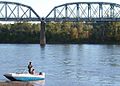
Fishermen on the Missouri River facing the Union Pacific Bridge.
-
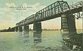
Union Pacific Bridge about 1909.
-
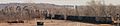
Coal train crossing the Union Pacific Bridge with the Loess Hills in background.
-
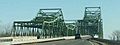
Mormon Bridge from Omaha going into Iowa. The original bridge is the east bound bridge on the right.
-
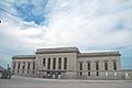
The main entrance to Omaha's Burlington Station.
-
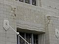
"Dedicated by the railways of Omaha the service, comfort and convenience of the people," etched in stone above an entrance to the Union Station in Omaha.
-
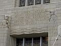
"No other improvement... can equal in utility the railroad," etched in stone above another doorway.
-
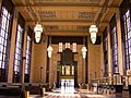
Interior of the Union Station in Omaha.
-
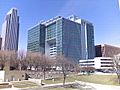
The Union Pacific Center in Downtown Omaha.


.jpg)
.jpg)
.JPG)

