Bishop's Stortford facts for kids
Quick facts for kids Bishop's Stortford |
|
|---|---|
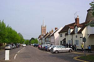 Looking down Windhill towards the town centre |
|
| Population | 41,088 (2020) |
| OS grid reference | TL495215 |
| Civil parish |
|
| District |
|
| Shire county | |
| Region | |
| Country | England |
| Sovereign state | United Kingdom |
| Post town | BISHOP'S STORTFORD |
| Postcode district | CM22, CM23 |
| Dialling code | 01279 |
| Police | Hertfordshire |
| Fire | Hertfordshire |
| Ambulance | East of England |
| EU Parliament | East of England |
| UK Parliament |
|
Bishop's Stortford is a lively market town and civil parish in Hertfordshire, England. It's located close to the border with Essex, not far from the M11 motorway and Stansted Airport. The town is about 22 miles north-east of Central London and you can get there by train from Liverpool Street station in about 34 minutes. In 2020, about 41,088 people lived here. Bishop's Stortford is in the East Hertfordshire area, which was named the best place to live in the UK in 2020!
Contents
History of Bishop's Stortford
How Bishop's Stortford Got Its Name
The exact reason for the town's name isn't fully known. One idea is that the old Saxon settlement was called 'Steorta's ford'. This might mean a 'ford' (a shallow place to cross a river) near a 'tail' or narrow piece of land. The town became known as Bishop's Stortford because the Bishop of London bought the area in 1060.
Interestingly, the River Stort was actually named after the town, not the other way around! When mapmakers visited in the 1500s, they thought the town must have been named after the river's ford, so they called the river the Stort.
Early Settlements: Roman Times
We don't know much about Bishop's Stortford until the Roman period. Small archaeological finds like tools and an axe have been discovered. Evidence of settlements from the Middle Bronze Age (about 3,000 years ago) through to Roman times has been found. It seems that the area wasn't heavily settled in prehistoric times.
Bishop's Stortford was on a Roman road called Stane Street, which connected St Albans to Colchester. This road was built around 50 AD. Not much Roman evidence remains, except for parts of the road, a cremation site, and a burial spot. There's no clear sign of a Roman fort, though one likely existed. The settlement was probably left empty around the 5th century when the Roman Empire broke up.
New Beginnings: After the Romans
After the Roman era, a new Anglo-Saxon settlement grew in the area.
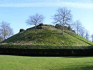
More is known about Bishop's Stortford from the 1060s, especially after the Norman Conquest. In 1060, William, the Bishop of London, bought the Stortford manor for £8. This led to the town's modern name. By 1086, Waytemore Castle, a motte-and-bailey castle (a type of castle with a mound and a walled courtyard), was built. It was a strong point for defence and local government for about 125 years. King John had it taken apart in 1211, but it was rebuilt the next year. By the 1400s, the castle was falling apart.
At the time of the Domesday Book in 1086, the village had about 120 people. This grew to around 700 by the 1200s.
Plague and Growth: Early Modern Times
In the mid-1400s, Bishop's Stortford was mainly a farming town. It also had a tanning industry (making leather). By the 1500s, it became a major centre for malting (preparing grain for brewing). The good soil for growing grains and its closeness to London helped it grow. The busy maltings and market meant the town had many inns and pubs, showing it was doing well.
Over the next 100 years, Bishop's Stortford grew a lot. The population reached 1,500 by 1660, even though there were many outbreaks of plague. The town also had royal visits in the 1600s, with King Charles I visiting three times.
The years after King Charles' visits were tough. During the English Civil War, Bishop's Stortford supported the Parliamentarians. The town's manor was taken from the Bishop of London and sold. It was given back when the monarchy returned. The Great Plague of 1666–67 severely reduced the population to only about 600 by 1700. The town had to ask for help from other areas to recover.
A big change for the town was the creation of the 'Hockerill by-pass' in 1670. King Charles II often travelled to Newmarket for races. He didn't like the noisy, smelly market, maltings, and tanneries in Bishop's Stortford. So, the road from London to Newmarket was moved to go through Hockerill, just east of the town centre. Hockerill's inns became important stops for coaches travelling to East Anglia. Later, better roads were built, and mail coaches ran from London to Norwich through Bishop's Stortford from 1785. These road improvements were the first step in the town's growth due to better transport.
The second major transport improvement was the Stort Navigation, which made the River Stort into a canal. It opened in 1769. This helped the malting industry, which had struggled to use the river for transport. The canal also helped reduce flooding in the town.
Industrial Revolution to World War II
With good roads and the Stort Navigation, industries came to Bishop's Stortford. New jobs appeared for bargemen, lock-keepers, and merchants selling coal and timber. The malting industry grew a lot, and the local brewing trade also boomed. By the early 1800s, there were 40 malthouses and 18 brewers in town. This also helped other businesses like metalworking, bricklaying, and shops.
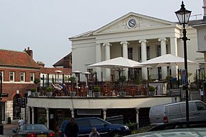
In 1828, local business people built the Bishop's Stortford Corn Exchange. This was a place for grain dealers to trade. By this time, the town had many businesses.
The third big transport change was the railway, which arrived in 1842. The line first connected London Liverpool Street to Bishop's Stortford. By 1845, it reached Norwich. The railway quickly ended the coaching industry and caused the Stort Navigation to decline. However, the town itself boomed! Many new homes were built, especially in the New Town and Hockerill. A branch line was built to Braintree in 1864 to bring goods from nearby rural areas. This line didn't do very well and closed to passengers in 1952.
The mid-1800s also saw rapid growth in public services. Gas street lights were installed in the 1830s. A new cemetery opened in 1855, and a sewage farm and hospital were built in the 1870s and 1890s. By 1911, the town was known for its good schools.
During World War II, Bishop's Stortford took in people who were evacuated from cities. But it wasn't safe from bombs. In 1940, 20 bombs were dropped, and the railway station was hit twice.
Modern Bishop's Stortford
After the war, the town centre changed. A multi-storey car park and other buildings were pulled down to make way for new shops and apartments. Jackson Square, a modern shopping centre, was rebuilt and made bigger.
Bishop's Stortford kept growing as a commuter town (where people live but travel to work elsewhere). This was helped by the building of the M11 motorway and Stansted Airport, as well as good train links to London and Cambridge. This caused the population to grow to almost 38,000 by 2011.
The town has several areas, including Thorley, Town, Havers, Stortford Fields, Bishop's Park, St Michael's Mead, and Snowley. Snowley is a separate church area east of the River Stort, known for its old coaching inns.
Population of Bishop's Stortford
The first reliable count of Bishop's Stortford's population was 120 in 1086. Over the centuries, the population changed due to economic growth and plagues. By the first national census in 1801, the population was 2,305, helped by the Hockerill Turnpike road and the canal. Growth continued as railways brought industrialisation.
Bishop's Stortford's population grew steadily, averaging 1.12% per year until World War I. Between the wars, it grew by 1.54% per year. In the 1961 census, Bishop's Stortford became larger than the county town of Hertford. The town's population has grown mainly from natural births and people moving in. The town's boundaries have also expanded over time, most recently in 1992 and 2018. In 2020, Bishop's Stortford was the biggest town in East Hertfordshire.
In 2011, most people in Bishop's Stortford (93.6%) described themselves as white. This was higher than the average for England (85.4%). Also, 87.8% of residents were born in the United Kingdom, which is similar to the English average. Bishop's Stortford had more residents born in the European Union than the average for East Hertfordshire or England.
Most homes in Bishop's Stortford are detached or semi-detached houses. The number of flats has grown, but it's still lower than the English average. A high number of households (72.3%) own their homes, which is more than the average for East Hertfordshire and England.
Economy and Business
Bishop's Stortford is a successful town. Its growth is driven by Stansted Airport, excellent train services to London, and good road links via the M11 to London, the M25, and Cambridge. The town is well-placed near some of the UK's busiest economic areas. Bishop's Stortford also has a skilled population and a high "quality of life," which makes it an attractive place to live and work.
Like the rest of the UK, Bishop's Stortford's economy is mostly based on services. In 2011, 84.5% of working residents were in service industries. A notable number (7.9%) work in Transportation and Storage, much higher than the English average. Stansted Airport is a major employer in this area, employing at least 1,000 people from Bishop's Stortford in 2013.
Many people who live in Bishop's Stortford commute (travel to work) elsewhere. About 3,000 people (15% of those working) commute by train, mostly to Central London. This means Bishop's Stortford has a higher number of people in management and professional jobs compared to the national average.
Bishop's Stortford also has a strong local economy, with an estimated 16,985 people working within the town itself. There are 329 businesses in the town centre. The town has a twice-weekly market and a monthly farmers market.
Local Media
The Bishop's Stortford Independent newspaper covers news for Bishop's Stortford and nearby towns like Sawbridgeworth and Stansted Mountfitchet. It started in 2017.
There are also local magazines like the Bishop's Stortford Flyer and CM23 Connection.
Local TV news is provided by BBC London and ITV London. You can also get BBC East and ITV Anglia. Local radio stations include BBC Three Counties Radio and Heart Hertfordshire.
Transport
Trains
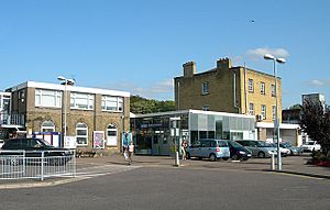
Bishop's Stortford railway station opened in 1842. In 2020/21, about 2 million passengers used the station.
Trains are run by Greater Anglia and offer three main routes:
- A fast service from Stansted Airport to London Liverpool Street, stopping only at Tottenham Hale.
- A service from Cambridge North to Liverpool Street, stopping at many stations.
- A direct service to Stratford in East London, stopping at most stations.
Epping tube station on the London Underground Central line is about 10 miles away. This line goes through Central London.
Roads
The M11 motorway runs east of Bishop's Stortford. Junction 8 connects the town to the motorway, which goes to Cambridge, Harlow, and London.
The A120 runs east–west along the north side of town. To the west, it connects to the A10. To the east, the A120 passes Stansted Airport and goes towards Braintree and Colchester.
Other important roads in town include:
- A1060 to Chelmsford
- A1184 to Sawbridgeworth and Harlow
- A1250 which goes through the town centre
- B1383 to Stansted Mountfitchet and Saffron Walden
Air quality is monitored at Hockerill Junction in the town centre.
Air Travel
Stansted Airport is just east of the town. You can get there by train or bus from Bishop's Stortford. It flies to over 200 places around the world.
Buses
Bishop's Stortford is part of the Arriva Herts & Essex bus network. Buses connect the town to Stansted Airport and Harlow. Other routes go to places like Hertford and Stevenage.
Cycling
Bishop's Stortford has several cycle routes:
- National Cycle Route 11 will eventually run through the town centre, connecting to the Lea Valley and King's Lynn.
- National Cycle Route 16 passes northeast of town, going to Great Dunmow and Braintree.
- The Bishop's Stortford Circular Ride is a fun route on country lanes north of town.
- The River Stort towpath is a path along the river that connects the town to Sawbridgeworth and Harlow. It's great for walking and cycling.
Landmarks
The old part of Bishop's Stortford is a special Conservation Area. It has 105 listed buildings, meaning they are historically important. Two of the most important are Waytemore Castle and St Michael's Church.
Castle Mound
Waytemore Castle started as a motte and bailey castle (a castle with a mound and a walled area) during the time of William the Conqueror. A large square tower was added later. It was used as a prison in the 1600s.
Today, you can only see the earthworks (mounds of earth) and the foundations of the old tower.
Corn Exchange
The Bishop's Stortford Corn Exchange is a building in the Greek Revival style (like ancient Greek temples), finished in 1828. It was used for trading grain. When grain trading became less common, it became a meeting place. Now, it's used by shops and businesses.
All Saints' Church
All Saints' Church, Hockerill was destroyed by fire in 1935. A new church was built in 1937, designed to be spacious and bright. It's a Grade II listed building, and its tower stands out on the eastern side of town. The church has a beautiful rose window and an old organ. Concerts are also held there.
Notable People
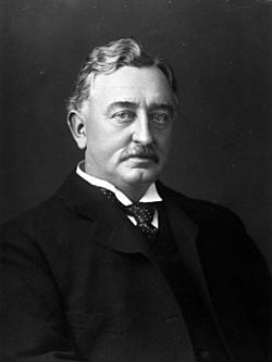
- Cecil Rhodes (1853–1902) was the son of a local vicar. He founded the region of Rhodesia (now Zambia and Zimbabwe) and the De Beers diamond company. He also started the Rhodes Scholarship.
- Sir Walter Gilbey, 1st Baronet was a businessman, wine merchant, and helped many charities.
- Caroline Spelman, a Conservative politician and former cabinet minister, was born here and went to the Hertfordshire and Essex High School.
- Paul Epworth (born 1974) is a record producer who has won many awards, including Grammys and an Academy Award (Oscar).
Education
Bishop's Stortford schools often appear in lists of the best schools in the country. Hockerill Anglo-European College, The Hertfordshire and Essex High School, and The Bishop's Stortford High School are often top performers. Hertfordshire County Council is in charge of the state schools here.
All state primary schools in Bishop's Stortford have nurseries. All state secondary schools have sixth forms (for older students). Bishop's Stortford High School is for boys, and Herts and Essex High School is for girls, but both have mixed-sex sixth forms. There's also a private school, the Bishop's Stortford College, for ages 4 to 18.
There are no colleges or universities in Bishop's Stortford itself. However, nearby options include Stansted Airport College and Harlow College.
| Schools | |
|---|---|
| State Nursery and Primary Schools | All Saints C of E Primary and Nursery School, Avanti Meadows Primary School, Hillmead Primary School, Manor Fields Primary School, Northgate Primary School, St Joseph's Catholic Primary, St Michael's C of E VA Primary, Summercroft Primary School, The Richard Whittington Primary School, Thorley Hill Primary School, Thorn Grove Primary School, Windhill21 |
| State Secondary Schools | Avanti Grange, Birchwood High School, The Bishop's Stortford High School, The Hertfordshire and Essex High School, Hockerill Anglo-European College, St Mary's Catholic School |
| Private Schools | Bishop's Stortford College |
Sport
Football
The semi-professional football team Bishop's Stortford F.C. was formed in 1874. They play at Woodside Park, which is actually in both Hertfordshire and Essex! They are currently in the National League North, which is the sixth level of English football. The club has won two national titles: the 1973–74 FA Amateur Cup and the 1980-81 FA Trophy. They were the first club to win both! Bishop's Stortford Community Football Club is one of the largest clubs of its kind in the country, with over 80 teams and nearly 1,000 members.
Hockey
Bishop's Stortford Hockey Club started in 1948. They have a clubhouse and a modern pitch at The Hertfordshire and Essex High School. They have many senior teams for men and ladies, and a very active junior section with over 500 members.
Cricket
Bishop's Stortford Cricket Club plays its home matches at Cricket Field Lane. This is also a home ground for Hertfordshire County Cricket Club. Thorley Cricket Club and Hockerill Cricket Club also play in Bishop's Stortford.
Rugby
Bishop's Stortford Rugby Football Club plays in National League 1, the third level of English rugby. The club has about 700 male players across its Mini, Youth, and Senior teams, plus over 80 female players.
Other Sports
Public sports facilities include the Grange Paddocks swimming pool and gym, a tennis club, a squash club, and a golf club. There's also a concrete skateboard park in the town park. The town council is improving this area to create a bigger "teenage recreation space."
Culture
South Mill Arts
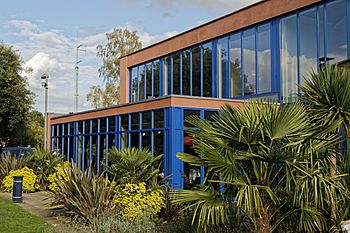
The South Mill Arts complex (formerly Rhodes Arts Complex) has a theatre, cinema, dance studio, and conference rooms. Inside the complex, in the house where Cecil Rhodes was born, is the Bishop's Stortford Museum. It has local history items and a special collection about Rhodes and the British Empire in Africa.
South Mill Arts is the town's biggest place for live music. In the 1960s, many famous musicians played there when they were just starting out, including David Bowie, Stevie Wonder, Lulu, The Who, and The Animals.
Other Fun Things to Do
In the town centre, there's a place called The Complex, Anchor Street Entertainment. It has a multiplex cinema, a health club, a bowling alley, and several restaurants.
The town has two amateur drama groups: The Water Lane Theatre Group and Bishop's Stortford Musical Theatre Company.
There are also various youth groups, including an Army Cadet Force, an Air Training Corps squadron, and Scout troops.
Fairs
Every December, there's an annual Christmas Fayre with over 100 stalls and family entertainment. There's also a summer Carnival with a procession of community groups, bands, fairground rides, and stalls.
Pubs
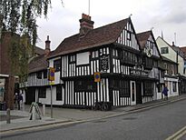
Because Bishop's Stortford was a market town and a major stop for coaches between London and Cambridge, it has many large public houses (pubs) in the town centre. For example, The Star in Bridge Street was a well-known inn.
Other historic pubs include the 15th-century Boars Head and the 16th-century Black Lion.
Geography
Bishop's Stortford grew up around the River Stort valley. The town centre is about 60 metres above sea level, rising to over 100 metres on the edges of town.

Being in the south-east of England, the town has a warmer climate than most of Britain. Summer temperatures can sometimes reach the mid-30s Celsius, and it's one of the driest places in the country. Snow can fall in winter because the town is near the east coast, which gets cold, moist air from the North Sea. However, the snow usually doesn't stay for long.
The town's water is supplied by Affinity Water. The water is considered very hard because it has a lot of minerals.
Climate
Bishop's Stortford has a temperate maritime climate, meaning it has cool summers and mild winters. The closest weather station is at Stansted Airport, about 2.5 miles east of the town centre. This area is slightly cooler than Cambridge to the north or London to the south, but still warmer than the average for England.
The highest temperature recorded at Stansted was 35.0°C during a heatwave in August 2003. On average, the hottest day of the year reaches about 28.8°C. The lowest temperature recorded was -14.7°C in December 1981. Very cold temperatures are not common because there aren't high mountains nearby to trap cold air.
Bishop's Stortford usually gets about 622 mm of rain each year. It rains 1 mm or more on about 115 days a year.
Arms
|
|
 | Victor J. Glover |
 | Yvonne Cagle |
 | Jeanette Epps |
 | Bernard A. Harris Jr. |


