Caroline County, Maryland facts for kids
Quick facts for kids
Caroline County
|
|||
|---|---|---|---|
|
County
|
|||

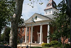
The Caroline County Courthouse in July 2012
|
|||
|
|||

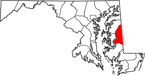
Location within the U.S. state of Maryland
|
|||
 Maryland's location within the U.S. |
|||
| Country | |||
| State | |||
| Founded | 1774 | ||
| Named for | Caroline Eden | ||
| Seat | Denton | ||
| Largest town | Denton | ||
| Area | |||
| • Total | 326 sq mi (840 km2) | ||
| • Land | 319 sq mi (830 km2) | ||
| • Water | 6.5 sq mi (17 km2) 2.0% | ||
| Population
(2020)
|
|||
| • Total | 33,293 | ||
| • Density | 102.13/sq mi (39.43/km2) | ||
| Time zone | UTC−5 (Eastern) | ||
| • Summer (DST) | UTC−4 (EDT) | ||
| Congressional district | 1st | ||
Caroline County is a rural county in the state of Maryland, USA. In 2020, about 33,293 people lived there. The main town and county seat is Denton. Caroline County is part of the "Mid-Eastern Shore" area of Maryland.
The county shares borders with Queen Anne's County to the north and Talbot County to the west. To the south is Dorchester County. On its eastern side, it borders Kent County, Delaware and Sussex County, Delaware.
Contents
History of Caroline County
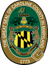
Caroline County was created in 1773 by the Maryland General Assembly. This is like the state's law-making group. It was formed from parts of Dorchester and Queen Anne's counties.
The county got its name from Lady Caroline Eden. She was the wife of Robert Eden, who was Maryland's last colonial governor. Seven people were chosen to be the first commissioners. These people bought land at a place called Pig Point, which is now Denton. They planned to build a courthouse and a jail there.
Before the buildings were ready, court meetings were held at Melvill's Warehouse. This place was about 1.5 miles (2.4 km) north of Pig Point. The first meeting of the commissioners happened there on March 15, 1774. Later, in 1777, the court moved to Bridgetown, which is now Greensboro. But for easier access, the court soon moved back to Melvill's.
There were some disagreements about where the county seat should permanently be. In 1785, the General Assembly decided that 2 acres (0.81 ha) of land at Melvill's Landing should be bought for a courthouse and jail. By 1790, the county court and its records moved to Pig Point. The Caroline County Courthouse was finished in 1797.
Many historic places in the county are listed on the National Register of Historic Places. The National Park Service is also creating a special site. This site will teach people about the Underground Railroad in the southern part of Caroline County. It's part of the Harriet Tubman Underground Railroad National Monument.
Geography of Caroline County
Caroline County covers about 326 square miles (844 km²). Most of this is land, about 319 square miles (826 km²). The rest, about 6.5 square miles (17 km²), is water. It is the second-smallest county in Maryland by total area. Important waterways include the Choptank River and Tuckahoe Creek. There is also a man-made lake called Williston Lake.
Caroline County is very good at protecting farmland. It ranks seventh in the nation for land saved under the Ag Preservation Program. This program helps keep farms as farms.
The county's eastern border is the famous Mason–Dixon line.
Caroline County is special because it's the only county on Maryland's Eastern Shore that doesn't touch the Chesapeake Bay or the Atlantic Ocean. Also, it's the only county on the Eastern Shore without a major Interstate or U.S. Highway.
You can find Tuckahoe State Park, Holiday Park Campgrounds, and Martinak State Park in Caroline County. The American Discovery Trail, a long hiking and biking path, also goes through the county.
Adjacent counties
- Kent County, Delaware (northeast)
- Sussex County, Delaware (southeast)
- Dorchester County (south)
- Talbot County (west)
- Queen Anne's County (northwest)
Population Facts
| Historical population | |||
|---|---|---|---|
| Census | Pop. | %± | |
| 1790 | 9,506 | — | |
| 1800 | 9,226 | −2.9% | |
| 1810 | 9,453 | 2.5% | |
| 1820 | 10,108 | 6.9% | |
| 1830 | 9,070 | −10.3% | |
| 1840 | 7,806 | −13.9% | |
| 1850 | 9,692 | 24.2% | |
| 1860 | 11,129 | 14.8% | |
| 1870 | 12,101 | 8.7% | |
| 1880 | 13,766 | 13.8% | |
| 1890 | 13,903 | 1.0% | |
| 1900 | 16,248 | 16.9% | |
| 1910 | 19,216 | 18.3% | |
| 1920 | 18,652 | −2.9% | |
| 1930 | 17,387 | −6.8% | |
| 1940 | 17,549 | 0.9% | |
| 1950 | 18,234 | 3.9% | |
| 1960 | 19,462 | 6.7% | |
| 1970 | 19,781 | 1.6% | |
| 1980 | 23,143 | 17.0% | |
| 1990 | 27,035 | 16.8% | |
| 2000 | 29,772 | 10.1% | |
| 2010 | 33,066 | 11.1% | |
| 2020 | 33,293 | 0.7% | |
| 2023 (est.) | 33,593 | 1.6% | |
| U.S. Decennial Census 1790-1960 1900-1990 1990-2000 2010 2020 |
|||
In 2020, Caroline County had a population of 33,293 people. Most residents were White (72.43%), followed by Black or African American (13.12%). About 8.47% of the population identified as Hispanic or Latino.
In 2010, there were 12,158 households in the county. About 36.3% of these households had children under 18 living with them. The average age of people in the county was 38.7 years old.
Education in Caroline County
Caroline County Public Schools manages the public schools in Caroline County.
- North Caroline High School
- Colonel Richardson High School
Media in Caroline County
The Caroline Review is a free newspaper that comes out once a month. There's also a digital news source called Caroline Past and Present, which started in 2018.
Fun Things to Do and See
- The towns of Hickman and Preston were once featured on the TV show Hee Haw. The Hickman part is even in the comedy section of the Country Music Hall of Fame.
- Baseball Hall of Famer Jimmie Foxx started his career playing baseball in Ridgely. Another Hall of Famer, Home Run Baker, also played for the town team.
- Rock musician George Thorogood played in Caroline County bars before he became famous. He was attending the University of Delaware at the time.
- In 2004, the South Caroline baseball team made it to the Little League World Series. They finished third in the entire nation!
- Summerfest is a fun event held every August in Denton.
- The Caroline-Dorchester County Fair takes place every August in Williston.
- The Strawberry Festival is held every Memorial Day weekend in Ridgely.
Transportation in Caroline County
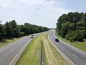
Caroline County is one of only three counties in Maryland that does not have a major Interstate or U.S. Highway running through it. The main road in Caroline County is Maryland Route 404. Some parts of it have four lanes, while others have two. This road is often used in the summer by people driving to beaches like Ocean City, Maryland or Rehoboth Beach, Delaware.
 MD 16
MD 16 MD 287
 MD 302
 MD 304
 MD 306
 MD 307
 MD 308
 MD 311
 MD 312
 MD 313
 MD 314
 MD 315
 MD 317
 MD 318
 MD 328
 MD 331
 MD 404
 MD 454
 MD 480
 MD 577
 MD 578
 MD 619
Towns and Communities
Towns
- Denton (county seat)
- Federalsburg
- Goldsboro
- Greensboro
- Henderson
- Hillsboro
- Marydel
- Preston
- Ridgely
- Templeville (partly in Queen Anne's County)
Census-designated places
These are special areas the U.S. Census Bureau uses for counting people.
Unincorporated communities
These are smaller communities that are not officially towns.
- American Corner
- Andersontown
- Baltimore Corner
- Bethlehem
- Brick Wall Landing
- Burrsville
- Gilpin Point
- Harmony
- Hickman
- Hobbs
- Jumptown
- Linchester
- Oakland
- Oil City
- Tanyard
- Two Johns
- Reliance (partial)
- Whiteleysburg
Famous People and Animals
- James Gordon Bennett Jr., a newspaper publisher, was part of a duel near Marydel in 1877.
- Buddy, was U.S. President Bill Clinton's chocolate Labrador Retriever.
- Charles Dickinson was involved in a duel in 1806 with future President Andrew Jackson.
- Frederick Douglass, a famous speaker and social reformer, was a former slave.
- Thomas Alan Goldsborough, a well-known judge and congressman.
- Harry R. Hughes, who was the Governor of Maryland from 1979 to 1987.
- Sophie Kerr, an author from the early 1900s. She left money for a big writing prize at Washington College.
- William Richardson, a hero from the Battle of Harlem Heights during the Revolutionary War.
- Thomas Alexander Smith, an early 20th-century congressman and businessman.
- Sherman W. Tribbitt, who was the Governor of Delaware from 1973 to 1977.
- Harriet Tubman, a brave abolitionist and humanitarian, who was also a former slave.
- George A. Waggaman, a U.S. senator from Louisiana.
See also
 In Spanish: Condado de Caroline (Maryland) para niños
 | Calvin Brent |
 | Walter T. Bailey |
 | Martha Cassell Thompson |
 | Alberta Jeannette Cassell |


