
Clinton County, Ohio facts for kids
Quick facts for kids
Clinton County
|
|||
|---|---|---|---|

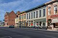
The Wilmington Commercial Historic District is on the National Register of Historic Places listings in Clinton County
|
|||
|
|||

Location within the U.S. state of Ohio
|
|||
 Ohio's location within the U.S. |
|||
| Country | |||
| State | |||
| Founded | March 1, 1810 | ||
| Named for | George Clinton | ||
| Seat | Wilmington | ||
| Largest city | Wilmington | ||
| Area | |||
| • Total | 412 sq mi (1,070 km2) | ||
| • Land | 409 sq mi (1,060 km2) | ||
| • Water | 3.6 sq mi (9 km2) 0.9%% | ||
| Population
(2020)
|
|||
| • Total | 42,018 |
||
| • Density | 102.7/sq mi (39.7/km2) | ||
| Time zone | UTC−5 (Eastern) | ||
| • Summer (DST) | UTC−4 (EDT) | ||
| Congressional district | 2nd | ||


Clinton County is a county in Ohio, a state in the United States. In 2020, about 42,018 people lived there. The biggest city and main town is Wilmington. The county got its name from George Clinton, who used to be a Vice President of the U.S. Clinton County is part of a larger area that includes Cincinnati.
Contents
Exploring Clinton County's Past
Clinton County was created on February 19, 1810. It was formed from parts of Highland County and Warren County. The law making it a county started on March 1 of that year. It was named after George Clinton. He was a soldier, a politician, and the Governor of New York. He also served as a Vice President of the United States.
Geography and Nature of Clinton County
Land and Water Features
According to the U.S. Census Bureau, Clinton County covers about 412 square miles (1,067 km²). Most of this area, about 409 square miles (1,060 km²), is land. The remaining 3.6 square miles (9.3 km²), or 0.9%, is water.
Most of the county is in the Little Miami River area. This means its rivers and streams flow into the Little Miami River. Only the far eastern parts flow into the Scioto River.
Flat Plains and Ice Age Clues
Clinton County is mostly flat or gently rolling. This area is known as till plains. Long ago, huge sheets of ice covered the northern two-thirds of the county. This happened during the Wisconsinan Ice Age. The southern part was covered by even older ice sheets during the Illinoian Ice Age. Because of these ice sheets, you can find many features left behind by glaciers. These include moraines (hills of rock and dirt) and kames (small hills of sand and gravel).
The land in the county is generally about 1,050 feet (320 meters) above sea level. Most areas don't change much from this height, usually by less than 200 feet (61 meters).
Climate and Weather Patterns
Clinton County has a humid continental climate. This means it has warm, humid summers and cold winters. It is one of the cooler and wetter counties in southern Ohio. However, the differences from other southern Ohio counties are usually small.
The county gets about 42 inches (1.1 meters) of precipitation each year. This includes about 30 inches (0.76 meters) of snow. In July, the average high temperatures are in the mid to upper 80s F (around 29-32°C). Temperatures above 90 F (32°C) are common. Lows are usually in the 60s F (around 16-20°C). In January, high temperatures are typically in the low to mid 30s F (around 0-2°C). Lows generally drop into the 10s F (around -12 to -7°C). It can also get below 0 F (-18°C) sometimes.
Neighboring Counties
- Greene County (north)
- Fayette County (northeast)
- Highland County (southeast)
- Brown County (south)
- Clermont County (southwest)
- Warren County (west)
Major Roads and Highways
- I-71
- US 22
- US 68
- SR 28
- SR 72
- SR 73
- SR 132
- SR 133
- SR 134
- SR 350
- SR 380
Population of Clinton County
| Historical population | |||
|---|---|---|---|
| Census | Pop. | %± | |
| 1810 | 2,674 | — | |
| 1820 | 8,085 | 202.4% | |
| 1830 | 11,436 | 41.4% | |
| 1840 | 15,719 | 37.5% | |
| 1850 | 18,838 | 19.8% | |
| 1860 | 21,461 | 13.9% | |
| 1870 | 21,914 | 2.1% | |
| 1880 | 24,756 | 13.0% | |
| 1890 | 24,240 | −2.1% | |
| 1900 | 24,202 | −0.2% | |
| 1910 | 23,680 | −2.2% | |
| 1920 | 23,036 | −2.7% | |
| 1930 | 21,547 | −6.5% | |
| 1940 | 22,574 | 4.8% | |
| 1950 | 25,572 | 13.3% | |
| 1960 | 30,004 | 17.3% | |
| 1970 | 31,464 | 4.9% | |
| 1980 | 34,603 | 10.0% | |
| 1990 | 35,415 | 2.3% | |
| 2000 | 40,543 | 14.5% | |
| 2010 | 42,040 | 3.7% | |
| 2020 | 42,018 | −0.1% | |
| U.S. Decennial Census 1790-1960 1900-1990 1990-2000 2020 |
|||
Quick Facts from 2010 Census
In 2010, there were 42,040 people living in Clinton County. There were 16,210 households and 11,364 families. The county had about 103 people per square mile.
Most people in the county were white (94.7%). About 2.2% were black or African American. About 0.5% were Asian, and 0.2% were American Indian. People of Hispanic or Latino origin made up 1.3% of the population.
Many people had German (26.4%), Irish (15.4%), American (12.0%), or English (11.9%) backgrounds.
About 33.5% of households had children under 18 living with them. The average age in the county was 38.7 years.
The average income for a household was $46,261. For families, it was $56,208. About 14.0% of the population lived below the poverty line. This included 18.6% of those under 18.
Schools in Clinton County
Many school districts serve the students of Clinton County. Some are mainly in Clinton County, while others are mostly in nearby counties.
- Blanchester Local School District (also in Brown, Clermont, and Warren counties)
- Clinton-Massie Local School District (also in Warren County)
- East Clinton Local School District (also in Fayette, Greene, and Highland counties)
- Fairfield Local School District (mainly in Highland County)
- Fayetteville-Perry Local School District (mainly in Brown County)
- Greeneview Local School District (mainly in Greene County)
- Lynchburg-Clay Local School District (mainly in Highland County)
- Miami Trace Local School District (mainly in Fayette County)
- Wilmington City School District (also in Greene County)
- Xenia Community School District (mainly in Greene County and Warren County)
Fun and Recreation
Clinton County offers many outdoor activities and local events.
Parks and Outdoor Adventures
Cowan Lake State Park is a great place for outdoor fun. Here, you can enjoy:
- Fishing
- Swimming
- Boating
- Hiking
- Bicycling
- Camping
- Watching wildlife
The northwestern edge of Clinton County touches Caesar Creek Lake. This lake is part of Caesar Creek State Park. Besides activities like those at Cowan Lake, fossil hunting is very popular here!
Local Sports and Festivals
Wilmington College in Wilmington has several sports teams. They are part of NCAA Division III. You can often attend their games and events. The city of Wilmington also hosts the annual Clinton County Corn Festival, a fun local celebration.
Getting Around Clinton County
Interstate 71 (I-71) runs through the northern part of the county. It connects Clinton County to bigger cities like Columbus, Ohio and Cincinnati.
U.S. Route 68 is a main road that goes north and south through the county. U.S. Route 22 runs east and west. Many other state and local roads help people travel around Clinton County.
Clinton Field is a public airport. It is located about 4 nautical miles (7 km) northwest of downtown Wilmington.
Towns and Communities

City
- Wilmington (This is the main county seat)
Villages
Townships
- Adams
- Chester
- Clark
- Green
- Jefferson
- Liberty
- Marion
- Richland
- Union
- Vernon
- Washington
- Wayne
- Wilson
Unincorporated communities
Ghost town
Images for kids
-
The Wilmington Commercial Historic District is on the National Register of Historic Places.
See also
 In Spanish: Condado de Clinton (Ohio) para niños
