Geography of Maryland facts for kids
The U.S. state of Maryland has a very interesting and different geography! It covers about 12,400 square miles (32,100 km²). This makes it similar in size to the country of Belgium. Maryland is the 42nd largest state, but also the 9th smallest. It's closest in size to Hawaii. Maryland shares borders with Pennsylvania to the north, Delaware to the northeast, and the Atlantic Ocean to the east. To its west and south are West Virginia and Virginia.
Contents
Maryland's Amazing Landscapes
Maryland is often called America in Miniature because it has so many different types of land.
- In the east, you'll find sandy dunes with seagrass.
- Near the Chesapeake Bay, there are low marshlands full of wildlife and tall bald cypress trees.
- The Piedmont Region has gently rolling hills covered in oak forests.
- In the western Maryland mountains, you'll see pine groves.
Maryland shares its borders with four states. To the north is Pennsylvania. To the north and east is Delaware. The Atlantic Ocean is to its east. To the south and west, across the Potomac River, are West Virginia and Virginia.
A special area called the District of Columbia (where Washington, D.C. is) sits right in the middle of Maryland's border with Virginia. This land was given to the U.S. government in 1790. The Chesapeake Bay almost cuts the state in half. The counties east of the bay are known as the Eastern Shore.
Most of Maryland's rivers and streams flow into the Chesapeake Bay. However, a small part of western Garrett County drains into the Mississippi River. The eastern part of Worcester County drains into Maryland's Atlantic coastal bays. A tiny bit of the northeast corner drains into the Delaware River. The Chesapeake Bay is so important to Maryland that some people want to call Maryland the "Bay State."
The highest point in Maryland is Hoye Crest. It's 3,360 feet (1,024 meters) tall and is in the southwest corner of Garrett County. This is near the border with West Virginia. Near the small town of Hancock in western Maryland, the state is very narrow. Less than 2 miles (3.2 km) separate its northern border (the Mason–Dixon line) and the Potomac River to the south.
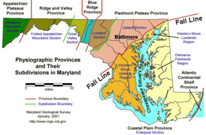
Maryland is part of several larger regions. The Delmarva Peninsula includes Maryland's Eastern Shore, all of Delaware, and two counties in Virginia. The western counties of Maryland are part of Appalachia. Much of the area between Baltimore and Washington, D.C., is in the Coastal Plain, but it also touches the Piedmont region.
Maryland's Land and Rocks (Geology)
Earthquakes in Maryland are rare and usually small. This is because the state is far from major earthquake zones. However, a 5.8 magnitude earthquake in Virginia in 2011 was felt across Maryland. Buildings here are not built to handle strong earthquakes, so they can be damaged easily.
Maryland does not have any natural lakes. This is because glaciers did not reach this area a long time ago. All the lakes you see in Maryland today were made by people, mostly by building dams.
Maryland also has shale rock formations that contain natural gas. While it's possible to get this gas through a process called fracking, Maryland has actually banned fracking.
Plants and Animals (Wildlife)
Amazing Plants (Flora)
Maryland has lots of healthy plant life, just like other states on the East Coast. It gets enough rain each year to support many different plants. These range from tiny seagrass and various reeds to giant trees. The famous Wye Oak was a huge example of a white oak, which is the state tree. White oaks can grow over 70 feet (21 meters) tall!
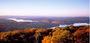
Around the Chesapeake Bay and on the Delmarva Peninsula, you'll find forests typical of the southeastern Atlantic coastal plain. As you move west, a mix of different forest types covers the central part of the state. The Appalachian Mountains in western Maryland are home to special mountain forests.
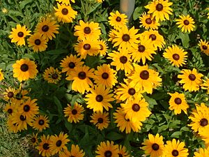
Many plants from other countries are grown in Maryland. Some are grown for their beauty, like the crape myrtle and southern magnolia. In warmer parts of the state, you can even find palm trees! Maryland's state flower, the black-eyed susan, grows wild in many places.

Cool Animals (Fauna)
Maryland is home to many animals. You'll find a lot of white-tailed deer, especially in the western, woody, and mountainous areas. Sometimes there are so many deer that it becomes a problem. Other mammals found across the state include black bears, bobcats, foxes, coyotes, raccoons, and otters.
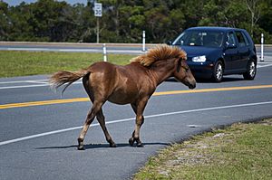
On Assateague Island, there's a special group of wild horses. People believe they are descendants of horses that escaped from Spanish shipwrecks a long time ago. Every July, these horses are rounded up and swim across a shallow bay to be sold. This helps make sure the island doesn't get too crowded with horses. The children's book Misty of Chincoteague made these ponies famous!
The Chesapeake Bay Retriever is a dog breed that was developed specifically for water sports, hunting, and rescue missions in the Chesapeake Bay area. This dog was the first retriever breed recognized by the American Kennel Club in 1878. It's also the mascot for the University of Maryland, Baltimore County.
Maryland's reptiles and amphibians include the diamondback terrapin turtle, which is the mascot for the University of Maryland, College Park. You can also find the threatened Eastern box turtle. The state bird is the Baltimore oriole, which is also the mascot for the MLB baseball team, the Baltimore Orioles. Besides the oriole, over 435 other types of birds have been seen in Maryland.
The state insect is the Baltimore checkerspot butterfly. Even though it's the state insect, it's not as common in Maryland as it is in other parts of its range.
Protecting the Environment

Maryland has worked with nearby states to make the Chesapeake Bay healthier. The bay's aquatic life and seafood industry have been at risk from pollution. This pollution comes from development, fertilizers, and animal waste flowing into the bay.
In 2007, Forbes.com said Maryland was the fifth "Greenest" state in the country. This means it's good at protecting the environment. Maryland uses less energy than most states. It also produced less toxic waste per person than all but six other states in 2005. In 2007, Maryland joined the Regional Greenhouse Gas Initiative. This is a group of states and Canadian provinces working to reduce greenhouse gas emissions. In 2017, Maryland became the first state with natural gas reserves to ban fracking by law.
Maryland's Weather (Climate)

Maryland has many different climates. This is because of changes in elevation, how close it is to water, and protection from cold winds.
The eastern half of Maryland, including cities like Ocean City, Salisbury, and Annapolis, is on the Atlantic Coastal Plain. This area is flat with sandy or muddy soil. It has a humid subtropical climate. This means it has hot, humid summers and cool to cold winters.
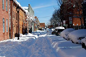
The Piedmont region includes areas like Baltimore, Westminster, and Frederick. This region usually gets more than 20 inches (51 cm) of snow each winter. Temperatures below 10°F (-12°C) are not as rare here. As you go further west, from the Cumberland Valley onward, the climate changes to a humid continental climate.
In western Maryland, the higher areas of Allegany and Garrett counties, including cities like Cumberland and Oakland, have more of a humid continental climate because of their elevation.
Maryland gets a lot of rain, typical for the East Coast. Annual rainfall is usually between 35 to 45 inches (890 to 1,140 mm). Higher elevations get even more rain. Almost every part of Maryland receives 3.5 to 4.5 inches (89 to 114 mm) of rain each month. The average annual snowfall changes a lot. Coastal areas get about 9 inches (23 cm), while the western mountains can get over 100 inches (250 cm)!
Because Maryland is near the Atlantic Coast, it can be affected by tropical cyclones (like hurricanes). However, the Delmarva Peninsula and the outer banks of North Carolina act like a big shield. This means major hurricanes (Category 3 or higher) don't hit Maryland very often. More often, Maryland gets the leftover rain and wind from a tropical storm that has already weakened after hitting land. Maryland usually has about 30-40 days with thunderstorms each year and averages about six tornado strikes annually.
Climate Data for Maryland Cities
| City | Jan | Feb | Mar | Apr | May | Jun | Jul | Aug | Sep | Oct | Nov | Dec |
|---|---|---|---|---|---|---|---|---|---|---|---|---|
| Oakland | 34 °F (1 °C) 16 °F (−9 °C) |
38 °F (3 °C) 17 °F (−8 °C) |
48 °F (9 °C) 25 °F (−4 °C) |
59 °F (15 °C) 34 °F (1 °C) |
68 °F (20 °C) 45 °F (7 °C) |
75 °F (24 °C) 53 °F (12 °C) |
79 °F (26 °C) 58 °F (14 °C) |
78 °F (26 °C) 56 °F (13 °C) |
71 °F (22 °C) 49 °F (9 °C) |
62 °F (17 °C) 37 °F (3 °C) |
50 °F (10 °C) 28 °F (−2 °C) |
39 °F (4 °C) 21 °F (−6 °C) |
| Cumberland | 41 °F (5 °C) 22 °F (−6 °C) |
46 °F (8 °C) 24 °F (−4 °C) |
56 °F (13 °C) 32 °F (0 °C) |
68 °F (20 °C) 41 °F (5 °C) |
77 °F (25 °C) 51 °F (11 °C) |
85 °F (29 °C) 60 °F (16 °C) |
89 °F (32 °C) 65 °F (18 °C) |
87 °F (31 °C) 63 °F (17 °C) |
80 °F (27 °C) 55 °F (13 °C) |
69 °F (21 °C) 43 °F (6 °C) |
57 °F (14 °C) 34 °F (1 °C) |
45 °F (7 °C) 26 °F (−3 °C) |
| Hagerstown | 39 °F (4 °C) 22 °F (−6 °C) |
42 °F (6 °C) 23 °F (−5 °C) |
52 °F (11 °C) 30 °F (−1 °C) |
63 °F (17 °C) 39 °F (4 °C) |
72 °F (22 °C) 50 °F (10 °C) |
81 °F (27 °C) 59 °F (15 °C) |
85 °F (29 °C) 64 °F (18 °C) |
83 °F (28 °C) 62 °F (17 °C) |
76 °F (24 °C) 54 °F (12 °C) |
65 °F (18 °C) 43 °F (6 °C) |
54 °F (12 °C) 34 °F (1 °C) |
43 °F (6 °C) 26 °F (−3 °C) |
| Frederick | 42 °F (6 °C) 26 °F (−3 °C) |
47 °F (8 °C) 28 °F (−2 °C) |
56 °F (13 °C) 35 °F (2 °C) |
68 °F (20 °C) 45 °F (7 °C) |
77 °F (25 °C) 54 °F (12 °C) |
85 °F (29 °C) 63 °F (17 °C) |
89 °F (32 °C) 68 °F (20 °C) |
87 °F (31 °C) 66 °F (19 °C) |
80 °F (27 °C) 59 °F (15 °C) |
68 °F (20 °C) 47 °F (8 °C) |
56 °F (13 °C) 38 °F (3 °C) |
45 °F (7 °C) 30 °F (−1 °C) |
| Baltimore | 42 °F (6 °C) 29 °F (−2 °C) |
46 °F (8 °C) 31 °F (−1 °C) |
54 °F (12 °C) 39 °F (4 °C) |
65 °F (18 °C) 48 °F (9 °C) |
75 °F (24 °C) 57 °F (14 °C) |
85 °F (29 °C) 67 °F (19 °C) |
90 °F (32 °C) 72 °F (22 °C) |
87 °F (31 °C) 71 °F (22 °C) |
80 °F (27 °C) 64 °F (18 °C) |
68 °F (20 °C) 52 °F (11 °C) |
58 °F (14 °C) 43 °F (6 °C) |
46 °F (8 °C) 33 °F (1 °C) |
| Elkton | 42 °F (6 °C) 24 °F (−4 °C) |
46 °F (8 °C) 26 °F (−3 °C) |
55 °F (13 °C) 32 °F (0 °C) |
67 °F (19 °C) 42 °F (6 °C) |
76 °F (24 °C) 51 °F (11 °C) |
85 °F (29 °C) 61 °F (16 °C) |
88 °F (31 °C) 66 °F (19 °C) |
87 °F (31 °C) 65 °F (18 °C) |
80 °F (27 °C) 57 °F (14 °C) |
69 °F (21 °C) 45 °F (7 °C) |
58 °F (14 °C) 36 °F (2 °C) |
46 °F (8 °C) 28 °F (−2 °C) |
| Ocean City | 45 °F (7 °C) 28 °F (−2 °C) |
46 °F (8 °C) 29 °F (−2 °C) |
53 °F (12 °C) 35 °F (2 °C) |
61 °F (16 °C) 44 °F (7 °C) |
70 °F (21 °C) 53 °F (12 °C) |
79 °F (26 °C) 63 °F (17 °C) |
84 °F (29 °C) 68 °F (20 °C) |
82 °F (28 °C) 67 °F (19 °C) |
77 °F (25 °C) 60 °F (16 °C) |
68 °F (20 °C) 51 °F (11 °C) |
58 °F (14 °C) 39 °F (4 °C) |
49 °F (9 °C) 32 °F (0 °C) |
| Waldorf | 44 °F (7 °C) 26 °F (−3 °C) |
49 °F (9 °C) 28 °F (−2 °C) |
58 °F (14 °C) 35 °F (2 °C) |
68 °F (20 °C) 43 °F (6 °C) |
75 °F (24 °C) 53 °F (12 °C) |
81 °F (27 °C) 62 °F (17 °C) |
85 °F (29 °C) 67 °F (19 °C) |
83 °F (28 °C) 65 °F (18 °C) |
78 °F (26 °C) 59 °F (15 °C) |
68 °F (20 °C) 47 °F (8 °C) |
59 °F (15 °C) 38 °F (3 °C) |
48 °F (9 °C) 30 °F (−1 °C) |
| Point Lookout State Park | 47 °F (8 °C) 29 °F (−2 °C) |
51 °F (11 °C) 31 °F (−1 °C) |
60 °F (16 °C) 38 °F (3 °C) |
70 °F (21 °C) 46 °F (8 °C) |
78 °F (26 °C) 55 °F (13 °C) |
86 °F (30 °C) 64 °F (18 °C) |
89 °F (32 °C) 69 °F (21 °C) |
87 °F (31 °C) 67 °F (19 °C) |
81 °F (27 °C) 60 °F (16 °C) |
71 °F (22 °C) 49 °F (9 °C) |
61 °F (16 °C) 41 °F (5 °C) |
50 °F (10 °C) 32 °F (0 °C) |
| ' | ||||||||||||
| Climate data for Baltimore (Baltimore/Washington International Airport) (1991−2020 normals, extremes 1872–present) | |||||||||||||
|---|---|---|---|---|---|---|---|---|---|---|---|---|---|
| Month | Jan | Feb | Mar | Apr | May | Jun | Jul | Aug | Sep | Oct | Nov | Dec | Year |
| Record high °F (°C) | 79 (26) |
83 (28) |
90 (32) |
94 (34) |
98 (37) |
105 (41) |
107 (42) |
105 (41) |
101 (38) |
98 (37) |
86 (30) |
77 (25) |
107 (42) |
| Mean daily maximum °F (°C) | 43.2 (6.2) |
46.4 (8.0) |
54.8 (12.7) |
66.5 (19.2) |
75.5 (24.2) |
84.4 (29.1) |
88.8 (31.6) |
86.5 (30.3) |
79.7 (26.5) |
68.3 (20.2) |
57.3 (14.1) |
47.5 (8.6) |
66.6 (19.2) |
| Daily mean °F (°C) | 34.3 (1.3) |
36.6 (2.6) |
44.3 (6.8) |
55.0 (12.8) |
64.4 (18.0) |
73.5 (23.1) |
78.3 (25.7) |
76.2 (24.6) |
69.2 (20.7) |
57.4 (14.1) |
46.9 (8.3) |
38.6 (3.7) |
56.2 (13.4) |
| Mean daily minimum °F (°C) | 25.4 (−3.7) |
26.9 (−2.8) |
33.9 (1.1) |
43.6 (6.4) |
53.3 (11.8) |
62.6 (17.0) |
67.7 (19.8) |
65.8 (18.8) |
58.8 (14.9) |
46.5 (8.1) |
36.5 (2.5) |
29.6 (−1.3) |
45.9 (7.7) |
| Record low °F (°C) | −7 (−22) |
−7 (−22) |
4 (−16) |
15 (−9) |
32 (0) |
40 (4) |
50 (10) |
45 (7) |
35 (2) |
25 (−4) |
12 (−11) |
−3 (−19) |
−7 (−22) |
| Average precipitation inches (mm) | 3.08 (78) |
2.90 (74) |
4.01 (102) |
3.39 (86) |
3.85 (98) |
3.98 (101) |
4.48 (114) |
4.09 (104) |
4.44 (113) |
3.94 (100) |
3.13 (80) |
3.71 (94) |
45.00 (1,143) |
| Average snowfall inches (cm) | 6.4 (16) |
7.5 (19) |
2.8 (7.1) |
0.0 (0.0) |
0.0 (0.0) |
0.0 (0.0) |
0.0 (0.0) |
0.0 (0.0) |
0.0 (0.0) |
0.0 (0.0) |
0.1 (0.25) |
2.5 (6.4) |
19.3 (49) |
| Average precipitation days (≥ 0.01 in) | 10.1 | 9.3 | 11.0 | 11.2 | 11.9 | 11.3 | 10.4 | 9.6 | 9.1 | 8.6 | 8.5 | 10.3 | 121.3 |
| Average snowy days (≥ 0.1 in) | 2.8 | 2.9 | 1.5 | 0.1 | 0.0 | 0.0 | 0.0 | 0.0 | 0.0 | 0.0 | 0.2 | 1.5 | 9.0 |
| Average relative humidity (%) | 63.2 | 61.3 | 59.2 | 58.9 | 66.1 | 68.4 | 69.1 | 71.1 | 71.3 | 69.5 | 66.5 | 65.5 | 65.8 |
| Mean monthly sunshine hours | 155.4 | 164.0 | 215.0 | 230.7 | 254.5 | 277.3 | 290.1 | 264.4 | 221.8 | 205.5 | 158.5 | 144.5 | 2,581.7 |
| Percent possible sunshine | 51 | 54 | 58 | 58 | 57 | 62 | 64 | 62 | 59 | 59 | 52 | 49 | 58 |
| Source: NOAA | |||||||||||||
| Sea temperature data for Baltimore | |||||||||||||
|---|---|---|---|---|---|---|---|---|---|---|---|---|---|
| Month | Jan | Feb | Mar | Apr | May | Jun | Jul | Aug | Sep | Oct | Nov | Dec | Year |
| Average sea temperature °F (°C) | 46.0 (7.8) |
44.4 (6.9) |
45.1 (7.3) |
50.4 (10.2) |
55.9 (13.3) |
68.2 (20.1) |
75.6 (24.2) |
77.4 (25.2) |
73.4 (23.0) |
66.0 (18.9) |
57.2 (14.0) |
50.7 (10.4) |
59.2 (15.1) |
| Mean daily daylight hours | 10.0 | 11.0 | 12.0 | 13.0 | 14.0 | 15.0 | 15.0 | 14.0 | 12.0 | 11.0 | 10.0 | 9.0 | 12.2 |
| Source: Weather Atlas | |||||||||||||
 | Precious Adams |
 | Lauren Anderson |
 | Janet Collins |


