
Geology of Mars facts for kids


The geology of Mars is the study of the Red Planet's surface, its outer layer (called the crust), and its inside. It helps us understand what Mars is made of, how it's built, its long history, and the natural forces that have shaped it. This field is much like studying Earth's geology. In space science, "geology" means looking at the solid parts of any planet or moon. It includes topics like geophysics (how planets work physically), geochemistry (what they're made of), mineralogy (their rocks and minerals), and cartography (making maps). Sometimes, you might hear the word areology used for Mars's geology. It comes from "Ares," the Greek name for Mars.
Contents
What Mars is Made Of
Mars is a terrestrial planet, meaning it's rocky like Earth. It has also gone through a process called planetary differentiation. This means its heavier materials sank to the center, forming layers like a core, mantle, and crust.
The InSight lander mission studied Mars's deep inside. It landed on November 26, 2018. InSight used a special tool called a seismometer to map the planet's inner layers. On October 25, 2023, scientists shared exciting news. They reported that Mars has a radioactive magma ocean flowing beneath its crust.
Mars's Big Surface Features
Mars has many huge features on its surface. These features show us the kinds of geological processes that have shaped the planet over a very long time. We will explore some of these big regions. They help us see how volcanoes, shifting ground, water, ice, and meteorite impacts have changed Mars globally.
Mars's Two Different Halves
Mars has two very different halves: its northern and southern hemispheres. This big difference is a key feature of the planet. The northern part is a huge low area. About one-third of Mars, mostly in the north, is 3 to 6 kilometers lower than the southern two-thirds. This is like the difference between Earth's continents and ocean floors.
The two halves also differ in how many craters they have and how thick their crust is. The southern half, called the southern highlands, has many craters and is very old. Its surface is rough and dates back to a time of heavy bombardment by space rocks. The northern lowlands, however, have few large craters. They are very smooth and flat. This shows that new material has covered the surface since the southern highlands formed.
The crust in the southern highlands can be up to 58 kilometers thick. But in the northern lowlands, it's thinner, around 32 kilometers thick. The exact line between these two halves changes across Mars.
Scientists still debate how and when this difference formed. Some think a giant impact, or several big impacts, created it early in Mars's history. Others believe it came from inside the planet. This could be from the northern crust becoming thinner due to processes deep within Mars. One idea suggested early plate tectonics might have thinned the northern crust. However, a newer theory, based on a giant impact at the South Pole, suggests that impacts are a stronger explanation. It also suggests Mars never had plate tectonics that could change this difference.
Studies using laser and radar from spacecraft have found many hidden, basin-sized structures. These are likely old impact craters covered by younger material. Counting these craters suggests the northern surface is as old as the oldest parts of the southern highlands. The very old age of this "dichotomy" is important for understanding its origin.
Giant Volcano Regions: Tharsis and Elysium

In Mars's western half, there's a huge area of volcanoes and cracked ground called the Tharsis region. This enormous, raised area is thousands of kilometers wide. It covers about a quarter of the planet's surface. Tharsis is 7 to 10 kilometers higher than Mars's "sea level." It holds the highest points on Mars and the largest known volcanoes in our Solar System.
Three giant volcanoes, Ascraeus Mons, Pavonis Mons, and Arsia Mons, are lined up along the top of Tharsis. They are known as the Tharsis Montes. The huge Alba Mons is in the northern part of this region. The massive shield volcano Olympus Mons sits just off the main Tharsis bulge.
The incredible weight of Tharsis has put huge stress on Mars's outer rocky layer, the lithosphere. This has caused giant cracks and valleys to spread out from Tharsis, reaching halfway around the planet.
A smaller volcanic area is found thousands of kilometers west of Tharsis, in Elysium. This volcanic complex is about 2,000 kilometers wide. It has three main volcanoes: Elysium Mons, Hecates Tholus, and Albor Tholus. Scientists think the Elysium volcanoes formed from both lava flows and explosive ash.
Huge Impact Basins
Mars has several enormous, round impact basins. The largest one we can easily see is the Hellas basin in the southern hemisphere. It's the second largest confirmed impact structure on Mars. The center of the basin is 1,800 kilometers wide. It's surrounded by a wide, worn-down rim of rugged mountains. These mountains are likely uplifted blocks of old crust.
Ancient, low volcanoes are found on the northeastern and southwestern parts of the rim. The basin floor has thick, complex layers of sediment. These layers show a long history of material being deposited, eroded, and changed. The lowest points on Mars are inside the Hellas basin, with some areas more than 8 kilometers below "sea level."
Two other large impact structures are the Argyre and Isidis basins. Like Hellas, Argyre (800 kilometers wide) is in the southern highlands. It's also surrounded by a wide ring of mountains. The mountains in its southern part may have been shaped by glaciers and ice sheets long ago. The Isidis basin (about 1,000 kilometers wide) sits on the line between Mars's two halves. Part of its rim has been eroded and buried by northern plains material, making it look like a half-circle.
Another large basin, Utopia, is completely buried by northern plains deposits. We can only see its outline using elevation data. All of Mars's large basins are extremely old. They date back to the time of heavy bombardment. They are thought to be as old as the Imbrium and Orientale basins on the Moon.
The Equatorial Canyon System

Near the equator in the western hemisphere is a massive system of deep, connected canyons. This is known as the Valles Marineris. This canyon system stretches eastward from Tharsis for over 4,000 kilometers. That's almost a quarter of the planet's circumference! If it were on Earth, Valles Marineris would span the entire width of North America. In some places, the canyons are up to 300 kilometers wide and 10 kilometers deep.
People often compare Valles Marineris to Earth's Grand Canyon. However, they formed in very different ways. The Grand Canyon was mostly carved by water erosion. The Martian equatorial canyons formed mainly from faulting, which is when the planet's crust breaks and shifts. They might be similar to the East African Rift valleys on Earth. These canyons show that Mars's crust was stretched and pulled apart. This stretching was likely caused by the huge weight of the Tharsis bulge.
Chaotic Terrain and Outflow Channels
At the eastern end of Valles Marineris, the landscape changes. It becomes a jumble of low, rounded hills. These areas, called chaotic terrain, seem to have formed when upland surfaces collapsed. This created broad, rubble-filled hollows.
These chaotic areas are where huge outflow channels begin. These channels emerge fully formed and flow northward into Chryse Planitia. Features like streamlined islands suggest that these channels were likely carved by massive floods of water. This water probably burst out from underground aquifers or came from melting subsurface ice. However, these features could also have been formed by large lava flows from Tharsis.
These channels, including Ares, Shalbatana, Simud, and Tiu Valles, are enormous. The floods that created them were incredibly powerful. For example, the flood needed to carve the 28-kilometer-wide Ares Vallis was estimated to be 14 million cubic meters per second. That's over ten thousand times the average flow of the Mississippi River!
Mars's Ice Caps

The polar ice caps are famous features of Mars, first seen through telescopes in 1672. Since the 1960s, we've known that the seasonal caps (those that grow and shrink with the seasons) are made of frozen carbon dioxide (CO2) ice. This ice forms when temperatures drop to 148 Kelvin (about -125 degrees Celsius) during the polar winter.
In the north, the CO2 ice completely disappears (sublimes) in summer. It leaves behind a permanent cap of water (H2O) ice. At the south pole, a small permanent cap of CO2 ice remains even in summer.
Both permanent ice caps sit on top of thick, layered deposits of ice and dust. In the north, these layers form a 3-kilometer-high, 1,000-kilometer-wide plateau called Planum Boreum. A similar plateau, Planum Australe, is in the south. These plateaus are sometimes called the polar ice caps. However, the permanent ice we see as white surfaces is only a thin layer on top of these layered deposits.
These layered deposits likely show alternating cycles of dust and ice. These cycles were caused by climate changes related to how Mars orbits the Sun over time. The polar layered deposits are some of the youngest geological features on Mars.
Mars's Geological History
Bright and Dark Areas on Mars

From Earth, we can't see mountains or valleys on Mars. Instead, we see bright and dark markings through a telescope. These are called albedo features. The bright, reddish-yellow areas are places where fine dust covers the surface. Bright areas include Hellas, Tharsis, and Arabia Terra.
The dark gray markings are areas where wind has swept away the dust. This leaves behind a lower layer of dark, rocky material. Dark markings are clearest in a wide belt from 0° to 40° South latitude. However, the most famous dark marking, Syrtis Major Planum, is in the northern hemisphere. Another prominent dark area in the north is Mare Acidalium (Acidalia Planitia). There are also areas with a mix of bright and dark materials, showing an intermediate color.
Impact Craters on Mars
Impact craters were first seen on Mars by the Mariner 4 spacecraft in 1965. Early observations showed that Martian craters were generally shallower and smoother than Moon craters. This means Mars has had more erosion and deposition than the Moon.
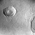
Martian craters are similar to lunar craters in other ways. Both are formed by very fast impacts. They also show different shapes as they get bigger. Craters on Mars smaller than about 7 kilometers wide are called simple craters. They are bowl-shaped with sharp, raised rims. Their depth is about one-fifth of their width.
Martian craters change from simple to more complex shapes at about 5 to 8 kilometers wide. Complex craters have central peaks (or groups of peaks), fairly flat floors, and terraces or slumps along their inner walls. Complex craters are shallower for their width than simple craters. Another change happens around 130 kilometers wide. Here, central peaks turn into rings of hills, forming multi-ring basins.
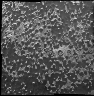
Mars has the most diverse types of impact craters of any planet in our Solar System. This is partly because its subsurface has both rocky and icy layers. This creates different crater shapes even for similar-sized impacts. Mars also has an atmosphere that affects how material is thrown out during an impact and how it erodes later. Mars has just enough volcanic and tectonic activity to preserve ancient, eroded craters. But it also has enough activity to resurface large areas. This creates a wide range of crater populations of different ages. Over 42,000 impact craters larger than 5 kilometers wide have been counted on Mars. The number of smaller craters is probably countless. The southern hemisphere has the most craters, especially large ones.
The shape of a crater tells us about the surface and subsurface when the impact happened. For example, central peaks in Martian craters are larger than those in similar craters on Mercury or the Moon. Also, many large craters on Mars have small pit craters at the top of their central peaks. These central pit craters are rare on the Moon but common on Mars and the icy moons of the outer Solar System. Large central peaks and many pit craters likely mean there was ice near the surface when the impact occurred. North and south of 30 degrees latitude, older craters look rounded or "softened." This is due to ground ice causing soil to slowly creep and move.
The most unique feature of Martian craters is their lobate (fluidized) ejecta blankets. Many craters near the equator and mid-latitudes on Mars have this type of ejecta. Scientists think this happens when the impacting object melts ice in the subsurface. The liquid water mixes with the ejected material, forming a muddy slurry. This slurry flows along the surface, creating the characteristic lobe shapes. The crater Yuty is a good example of a rampart crater. It's named for the rampart-like edge of its ejecta blanket.
Martian craters are often grouped by their ejecta layers. Craters with one ejecta layer are called single-layer ejecta (SLE) craters. Those with two layers are double-layer ejecta (DLE) craters. Craters with more than two layers are multiple-layered ejecta (MLE) craters. These differences in shape likely show different materials (like layers of ice, rock, or water) in the subsurface at the time of impact.

Martian craters show many different states of preservation. Some are very fresh, while others are old and eroded. Degraded and filled-in impact craters record changes in volcanic, fluvial (water-related), and wind-related activity over geological time. Pedestal craters are craters where their ejected material sits above the surrounding land. This forms raised platforms. They occur because the crater's ejecta creates a tough layer. This layer resists erosion more than the surrounding area. Some pedestals were hundreds of meters above the land, meaning hundreds of meters of material eroded away. Pedestal craters were first seen during the Mariner 9 mission in 1972.
Volcanic Activity on Mars

Volcanic structures and landforms cover large parts of Mars. The most obvious volcanoes are in Tharsis and Elysium. Geologists believe one reason Mars's volcanoes grew so large is that Mars has fewer tectonic boundaries than Earth. Lava from a stationary hot spot could build up in one place for hundreds of millions of years.
Scientists have never recorded an active volcano eruption on Mars. Searches for heat signals and surface changes in the last decade have not found proof of active volcanism.
On October 17, 2012, the Curiosity rover on Mars performed the first X-ray diffraction analysis of Martian soil at "Rocknest". The rover's CheMin analyzer found several minerals, including feldspar, pyroxenes, and olivine. This suggested that the Martian soil was similar to the "weathered basaltic soils" found near Hawaiian volcanoes. In July 2015, the same rover found tridymite in a rock sample from Gale Crater. This led scientists to think that a type of volcanism called silicic volcanism might have been more common on Mars than previously thought.
Sediments and How They Formed
Flowing water seems to have been common on Mars at different times in its history, especially on ancient Mars. Much of this water carved the surface, forming valley networks and creating sediment. This sediment was then deposited in many wet places. These included alluvial fans, winding channels, deltas, lakes, and perhaps even oceans. The way these sediments were deposited and moved depended on gravity, water flow, and speed. This created different Martian landscapes. There are other ways to estimate how much water was on ancient Mars. Groundwater also played a role. It helped cement wind-blown sediments and formed many sedimentary minerals like clays, sulfates, and hematite.
When the surface was dry, wind became a major force. Wind-driven sand features like large ripples and dunes are very common on Mars today. The Opportunity rover found many wind-blown sandstones during its journey. Ventifacts, like the rock named Jake Matijevic (rock), are another type of wind-shaped feature on Mars.
Many other types of sedimentary deposits are also found on Mars. These include glacial deposits, hot springs, dry landslides, and features formed by freezing and thawing. Rovers at Meridiani Planum and Gale Crater have observed evidence of ancient rivers, a lake, and dune fields in the preserved rock layers.
Common Surface Features of Mars
Underground Water on Mars
One group of researchers suggested that some of the layers on Mars were formed by groundwater rising to the surface. This happened in many places, especially inside craters. According to this idea, groundwater with dissolved minerals came to the surface. It then helped form layers by adding minerals (especially sulfate) and cementing sediments. This idea is supported by a groundwater model and by sulfates found over a wide area.
First, by studying surface materials with the Opportunity Rover, scientists found that groundwater had repeatedly risen and deposited sulfates. Later studies with instruments on the Mars Reconnaissance Orbiter showed that the same kinds of materials existed in a large area, including Arabia.
Interesting Geological Features
Avalanches on Mars
On February 19, 2008, images from the HiRISE camera on the Mars Reconnaissance Orbiter showed a spectacular avalanche. Debris, thought to be fine ice, dust, and large blocks, fell from a 700-meter-high cliff. Evidence of the avalanche included dust clouds rising from the cliff afterward. Scientists believe such events cause geological patterns known as slope streaks.
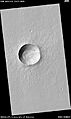
Possible Caves on Mars
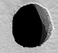
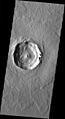
NASA scientists studying pictures from the Odyssey spacecraft have spotted what might be seven caves on the sides of the Arsia Mons volcano on Mars. The pit entrances measure from 100 to 252 meters wide. They are thought to be at least 73 to 96 meters deep. The pits have been informally named (A) Dena, (B) Chloe, (C) Wendy, (D) Annie, (E) Abby (left) and Nikki, and (F) Jeanne. Dena's floor was observed and found to be 130 meters deep. Further study suggested these were not necessarily lava tube "skylights." Reviewing the images has led to even more discoveries of deep pits.
A global database (MGC3) of over 1,000 possible Martian cave entrances at Tharsis Montes has been created by the USGS Astrogeology Science Center. In 2021, scientists applied machine-learning algorithms to find more cave candidates across all of Mars.
It has been suggested that human explorers on Mars could use lava tubes as shelters. These caves may be the only natural structures offering protection from tiny meteoroids, UV radiation, solar flares, and high-energy particles that bombard the planet's surface. These features might help preserve signs of past life for long periods. This makes caves an exciting target for astrobiology in the search for life beyond Earth.
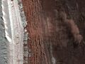
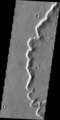
Inverted Relief: Streams That Became Ridges
Some areas of Mars show inverted relief. This means features that were once low areas, like streams, are now higher than the surrounding surface. Scientists believe that materials like large rocks were deposited in these low-lying areas. Later, wind erosion removed much of the surface layers. But it left behind the more resistant deposits.
Other ways inverted relief might form include lava flowing down a stream bed. Or, materials could be cemented by minerals dissolved in water. On Earth, materials cemented by silica are very resistant to erosion. Examples of inverted channels on Earth are found in the Cedar Mountain Formation near Green River, Utah. Inverted relief shaped like stream channels provides more evidence that water once flowed on Mars. These inverted channels suggest that the climate was much wetter when they formed.
In an article published in 2010, many scientists supported the idea of searching for life in Miyamoto Crater. This was because of its inverted stream channels and minerals that showed water was present in the past.
Images for kids
-
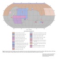
Figure 2 for the geologic map of Mars
-
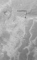
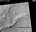
Inverted streams near Juventae Chasma, as seen by Mars Global Surveyor. These streams begin at the top of a ridge then run together.
-
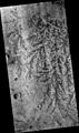
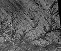
Inverted channel with many branches in Syrtis Major quadrangle.
-
Inverted stream channels in Antoniadi Crater in Syrtis Major quadrangle, as seen by HiRISE.
-
Inverted channel in Miyamoto Crater, in Margaritifer Sinus quadrangle, as seen by HiRISE.
-
A cave on Mars ("Jeanne") as seen by the Mars Reconnaissance Orbiter.
-
HiRISE closeup of Jeanne showing afternoon light on the east wall of the shaft.
-
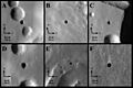
THEMIS image of cave entrances on Mars.
-
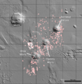
Map of 1,000+ possible cave-entrances at Tharsis Montes
-
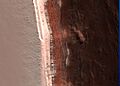
Image of the February 19, 2008 Mars avalanche captured by the Mars Reconnaissance Orbiter.
-
Closer shot of the avalanche.
-

Dust clouds rise above the 700-meter-deep cliff.
-
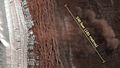
A photo with scale demonstrates the size of the avalanche.
-
HiRISE image of a simple rayed crater on the southeastern side of Elysium Mons.
-
THEMIS image of a complex crater with fluidized ejecta. Notice the central peak with a pit crater.
-
Viking orbiter image of Yuty crater showing lobate ejecta.
-
THEMIS close-up view of ejecta from a 17-km wide crater at 21°S, 285°E. Notice the prominent rampart.
-
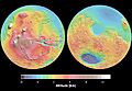
Mars Orbital Laser Altimeter (MOLA) maps show elevations. The western hemisphere (left) has the Tharsis region (red/brown) and Valles Marineris (blue). The eastern hemisphere (right) has cratered highlands (yellow/red) and the Hellas basin (deep blue/purple).


See also
- Areography (geography of Mars)
- Carbonates on Mars
- Chemical gardening
- Chloride-bearing deposits on Mars
- Composition of Mars
- Elysium Planitia
- Fretted terrain
- Geological history of Mars
- Glaciers on Mars
- Groundwater on Mars
- Hecates Tholus
- Lakes on Mars
- Life on Mars
- List of quadrangles on Mars
- List of rocks on Mars
- Magnetic field of Mars
- Mars Geyser Hopper
- Martian craters
- Martian dichotomy
- Martian geyser
- Martian gullies
- Martian soil
- Mineralogy of Mars
- Ore resources on Mars
- Scientific information from the Mars Exploration Rover mission
- Seasonal flows on warm Martian slopes
- Vallis
- Water on Mars
