
Lakes on Mars facts for kids

When we first saw close-up pictures of Mars in 1965, it looked like a dry, dusty desert with many craters. There were no signs of water. But over many years, as we sent better cameras and more advanced satellites, Mars started to tell a different story. Scientists found clues of ancient river valleys and lakes. They also found ice today, hidden in glaciers and underground. Mars's climate changes a lot over long periods because it doesn't have a big moon like Earth to keep its tilt steady. Some scientists also think that liquid water might have existed on the surface for a while. This could be due to heat from inside the planet, special rock mixtures, or even asteroid crashes. This article will explore some of the places on Mars that might have once held huge lakes.
Contents
- Discovering Water on Mars
- Mars's Ancient Ocean
- Valles Marineris Canyon System
- Hellas Basin's Ancient Lake
- Gale Crater's Lake History
- Holden Crater's Watery Past
- Western Elysium Planitia Paleolake
- Argyre Basin's Giant Lake
- Ritchey Crater's Lake Evidence
- Jezero Crater and Perseverance
- Eridania Lake: A Vast Ancient Sea
- Columbus Crater's Evaporating Lake
- Navua Valles
- Southern Polar Cap Subglacial Lake
- Images for kids
- See also
Discovering Water on Mars
Besides seeing features that looked like past surface water, scientists found other types of evidence. Minerals found in many places needed water to form. An instrument on the 2001 Mars Odyssey orbiter mapped where water was hidden just below the surface. When the Phoenix lander touched down in the far north, its rockets exposed ice.
When water flows into a large body of water, like a lake, it can form a delta. Many craters and dips on Mars show deltas that look like those on Earth. Also, if a lake sits in a low area, all the channels flowing into it would stop at the same height. We can see this pattern around places on Mars that scientists believe once held large amounts of water. This includes a possible ocean in the north.
Scientists have thought about past lakes on Mars for a long time. One study found 205 possible lakes in craters that had an inlet but no outlet. The total amount of water in these basins would cover Mars with 1.2 meters of water. However, this is only a small part of the ice currently stored on Mars. Another study found 210 lakes with both an inlet and an outlet. This means water must have filled these basins up to the level of the outlet. Some of these lakes were as big as Earth's Caspian Sea, Black Sea, or Lake Baikal.
A study from 2018 found 64 ancient lakes in the northwest Hellas region. Scientists suggested these lakes formed from an ocean that filled the Hellas basin. Data from the CRISM instrument showed minerals like clays and chlorides, which form in water. Forty-eight possible extinct lakes were found in Arabia Terra. Some had outlet channels, meaning water flowed out of them. These lakes varied in size from tens of meters to tens of kilometers. Many were found by looking for inverted reliefs, where old riverbeds now stand higher than the surrounding land.
Some lakes in craters in Terra Sabaea likely formed from melting glaciers on the crater rims. Inverted streams are found on some crater floors. Water from glaciers carried rocks and dirt in channels. This debris was left behind after the surrounding ground wore away.
In a study released in 2018, researchers found 34 ancient lakes and channels in the northeastern Hellas Basin. Some were near the Hadriacus volcano. Heat from the volcano could have melted ice, creating these lakes. Some lakes seemed to form from rain, others from groundwater.
Some basins on Mars are part of long chains of lakes. The Naktong/Scamander/Mamers Valles system is about 4,500 km (2,800 mi) long. Its drainage area is similar to the Missouri-Mississippi rivers on Earth. Another system, Samara/Himera Vallis, is 1,800 km (1,100 mi) long. Many of these long lake chains are in the Margaritifer Sinus quadrangle.
Some lakes seemed to have a lot of water compared to their drainage area. This suggests that some water came from underground. Another clue is the bumpy material on the basin floors. These bumps might have formed when large amounts of water left the ground.
In February 2019, European scientists published evidence of an ancient planet-wide groundwater system. This system was likely connected to a Martian ocean. The study looked at 24 craters without inlets or outlets. This meant the water for their lakes must have come from underground. All these craters were in Mars's northern hemisphere. Their floors were about 4,000 meters (13,000 ft) below Mars's "sea level." Features on these crater floors could only have formed with water present. Many craters showed signs that water levels rose and fell over time. Deltas and terraces were found in some. Minerals like clays, which form in water, were also present. Layers in some craters further suggest water was there. Some craters studied included Pettit, Sagan, Nicholson, and Mclaughlin. It seems that if a crater was deep enough, water came out of the ground and formed a lake.
Mars's Ancient Ocean


The Mars ocean hypothesis suggests that nearly one-third of Mars's surface was covered by a liquid water ocean long ago. This ancient ocean, called paleo-ocean or Oceanus Borealis, would have filled the Vastitas Borealis basin. This northern region is 4–5 km (2.5–3 mi) below the planet's average height. Scientists believe this happened about 3.8 billion years ago. Clues for this ocean include landforms that look like old shorelines. Also, the chemical makeup of Martian soil and air supports this idea. For such an ocean to exist, early Mars would have needed a magnetosphere, a thicker atmosphere, and a warmer climate. These conditions would have allowed liquid water to stay on the surface.
Clues from Observations
Pictures from the Viking orbiters in 1976 showed two possible ancient shorelines. These were near the pole, in Arabia and Deuteronilus. Each was thousands of kilometers long. Many features on Mars today suggest a past ocean. Networks of small valleys that join into larger channels look like ancient riverbeds on Earth. These suggest erosion by flowing liquid. Huge channels, 25 km (15.5 mi) wide and hundreds of meters deep, seem to have flowed from underground water sources in the southern uplands into the northern plains.
Much of Mars's northern hemisphere is much lower than the rest of the planet. This area is also unusually flat. This low elevation would cause water to gather there if it existed. An ocean would also tend to flatten the ground beneath it.
The idea of a vast northern ocean has been debated for decades. In 1998, scientists Michael Malin and Kenneth Edgett used cameras on the Mars Global Surveyor. These cameras had much better resolution than the Viking orbiters. They investigated areas that others had suggested were shorelines. Their study was not clear. They reported that the shoreline varied in height by several kilometers over thousands of miles. This raised doubts about whether these features were truly old sea coasts. This report was used as an argument against the Martian shoreline hypothesis.
Research published in 2009 showed many more stream channels than previously thought. Regions on Mars with the most valleys are similar to what we find on Earth. The research team used a computer program to find U-shaped valleys in topographical data. The large number of valley networks strongly suggests that it rained on Mars in the past. A large ocean in the northern hemisphere could explain the global pattern of these valleys. It would also explain why there is a southern limit to valley networks. The southernmost regions, farthest from the water, would get little rain and form no valleys. Similarly, less rainfall would explain why Martian valleys become shallower from north to south.
A 2010 study of river deltas on Mars found that seventeen of them were at the same height as a proposed shoreline for a Martian ocean. This is what scientists would expect if all the deltas were next to a large body of water.
Research published in 2012 used data from MARSIS, a radar on the Mars Express orbiter. This data supported the idea of a former large northern ocean. The instrument showed that the surface had properties similar to low-density sediments or large amounts of ground-ice. These measurements were not like those of a surface rich in lava.
In March 2015, scientists announced evidence for an ancient volume of water. This water could have formed an ocean, likely in Mars's northern hemisphere. It would have been about the size of Earth's Arctic Ocean. This finding came from comparing the ratio of water and deuterium in Mars's atmosphere today to that on Earth. Telescopic observations showed eight times more deuterium in Mars's polar ice than on Earth. This suggests ancient Mars had much more water. The atmospheric value (7 VSMOW) was not affected by local climate. It was also similar to the enrichment measured by the Curiosity rover in Gale Crater (5–7 VSMOW).
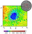
Valles Marineris Canyon System

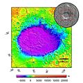
Map of Coprates quadrangle from Mars Orbiter Laser Altimeter (MOLA) data. The highest elevations are red and the lowest are blue.
|
|
| Coordinates | 15°00′S 67°30′W / 15°S 67.5°W |
|---|---|
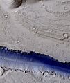
Valles Marineris is the largest canyon system in our Solar System. Many clues suggest that all or parts of this canyon system once held lakes. It is located in the Coprates quadrangle. The canyon walls often have many layers. The floors of some canyons contain large deposits of layered materials. Some scientists think these layers formed when water once filled the canyons.
Layered deposits, called interior layered deposits (ILDs), are found in parts of Valles Marineris. These are especially clear in Candor Chasma and Juventae Chasma. Many researchers suspect they formed when the entire area was a giant lake. However, other ideas have been suggested to explain them. High-resolution mapping in west Candor Chasma, presented in March 2015, showed that the deposits on the floor were sediments. These sediments were laid down in a wet, playa-like setting, meaning water was involved.
Minerals that usually need water to form have been found in ILDs. This supports the idea of water in the system. The European Space Agency's Mars Express found possible evidence for sulfates like epsomite and kieserite. These minerals form in water. Crystalline grey hematite, a form of ferric oxide, was also detected. Hematite typically needs water to form.
While there is debate about a single huge lake filling all of Valles Marineris, there is strong evidence for smaller lakes.
Melas Chasma is thought to have once contained a lake. It is the deepest part of the Valles Marineris system, 11 km (6.8 mi) below the surrounding surface. From here to the outflow channels, there is a slight upward slope to the northern plains. This means if the canyon filled with liquid, a 1 km (0.6 mi) deep lake would form before water flowed out. Melas Chasma is the widest part of the Valles Marineris canyon system. It is located east of Ius Chasma at 9.8°S, 283.6°E in Coprates quadrangle. It cuts through layered deposits that are believed to be sediments from an old lake. This lake resulted from water flowing from valley networks to the west. Evidence for lots of past water in Melas Chasma comes from the discovery of hydrated sulfates by MRO. These sulfates need water to form. Also, a 2015 study of southwestern Melas Chasma found eleven fan-shaped landforms. These fans add to the evidence that Melas Chasma once held a lake with changing water levels. A lake could have formed from runoff from local valley networks.
Scientists have described strong evidence for a lake in the eastern part of Valles Marineris, especially in Coprates Chasma. This lake would have had an average depth of 842 meters (2,762 ft). This is much shallower than the 5–10 km (3–6 mi) depth of some parts of Valles Marineris. Still, its volume of 110,000 km3 would be similar to Earth's Caspian Sea. The main evidence for such a lake is the presence of benches at the level where models show the lake surface should have been. Also, the low point in Eos Chasma, where water would have overflowed, shows signs of water flow. These features look as if water gathered in a small area and caused significant erosion.
Hellas Basin's Ancient Lake
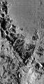
The Hellas quadrangle contains part of the Hellas Basin. This is the largest known impact crater on Mars and the second largest in the Solar System. The crater is 7,152 meters (23,000 ft) deep below Mars's standard elevation level. The basin is in the southern highlands of Mars. It is thought to have formed about 3.9 billion years ago, during a time of heavy impacts.
Scientists believe a large lake existed in the Hellas Basin early in Mars's history. It might have been 5.5 km (3.4 mi) deep. Possible shorelines have been discovered. These shorelines appear as alternating benches and scarps in images from the Mars orbiting camera. A good example of layers deposited in Hellas, and later exposed by erosion, is visible in Terby Crater on the north rim of Hellas. It was once thought that Terby Crater contained a large delta. However, later observations suggest these layers are part of a larger group that might have spread across all of Hellas. There is no valley at Terby's northern rim large enough to have carried the huge amount of sediments needed for these layers. Other observations also argue against Terby having a delta. In addition, Mars orbiting laser altimeter (MOLA) data show that these sedimentary units mark constant elevation contours for thousands of kilometers, and sometimes all around the basin.
Channels, believed to be formed by water, enter the basin from all sides.

Dao Vallis begins near a large volcano, Hadriaca Patera. So, it is thought to have received water when hot magma melted huge amounts of ice in the frozen ground. The partially circular depressions on the left side of the channel suggest that groundwater also contributed water.
The Hellas drainage basin may be almost one-fifth the area of the entire northern plains. A lake in Hellas, in today's Martian climate, would form thick ice on top. This ice would eventually disappear by sublimation. This means the ice would turn directly from solid to gas, like dry ice on Earth. Glacial features like moraines, drumlins, and eskers have been found. These may have formed when the water froze.
A lake filling the Hellas Basin may have lasted a very long time. This is especially true if there were some heat sources from inside the planet. Because of this, tiny life forms might have had time to develop there.
Gale Crater's Lake History

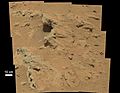
Gale is a crater on Mars near the northwestern part of the Aeolis quadrangle. Gale is 154 km (96 mi) across. It holds a central peak, Aeolis Mons (also called "Mount Sharp"), which rises higher from the crater floor than Mount Rainier rises above Seattle. Strong evidence suggests that Gale Crater once held a large lake. On August 6, 2012, the Mars Science Laboratory landed on Aeolis Palus near Aeolis Mons in Gale Crater.
On August 5, 2012, the Mars Science Laboratory rover, Curiosity, landed at the foot of a layered mountain inside Gale crater. As the mission continued, NASA released discoveries and conclusions. These detailed the growing evidence that Gale once contained a large lake. On September 27, 2012, scientists announced that Curiosity found evidence for an ancient streambed. This suggested a "vigorous flow" of water on Mars. On December 9, 2013, NASA reported that Gale Crater contained an ancient freshwater lake. This lake could have been a good place for microbial life to live.
Curiosity found fine-grained sedimentary rocks. These rocks represent an ancient lake that would have been suitable for life based on certain chemical processes. This liquid water environment had a neutral pH (not too acidic or basic), low saltiness, and iron and sulfur in forms usable by some microorganisms. Carbon, hydrogen, oxygen, sulfur, nitrogen—the essential elements for life—were measured. Gale's ancient lake might have lasted for hundreds to tens of thousands of years.
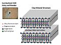
Clay minerals (trioctahedral) that form in the presence of water were found by Curiosity in sedimentary rocks (mudstones) at Yellowknife Bay in Gale Crater. The mudstone samples were named John Klein and Cumberland. They are thought to have formed later than the Noachian period. This means water may have existed there longer than previously believed.
Gale Crater contains several alluvial fans and deltas. These provide information about past lake levels. These formations include Pancake Delta, Western Delta, Farah Vallis delta, and the Peace Vallis Fan.
In a press conference on December 8, 2014, Mars scientists discussed Curiosity rover observations. These showed that Mars's Mount Sharp was built by sediments deposited in a large lake bed over tens of millions of years. This finding suggests that the climate of ancient Mars could have created long-lasting lakes in many places. Rock layers indicate that a huge lake filled and evaporated many times. The evidence was many deltas stacked on top of each other.

Gale Crater is considered a closed-basin lake. This means channels lead into it, but none lead out.
Minerals called clays and sulfates form only when water is present. They may also preserve signs of past life. The history of water at Gale, recorded in its rocks, gives Curiosity many clues. The rover is piecing together whether Mars could have ever supported microbes. Gale is special because both clays and sulfate minerals, which formed in water under different conditions, can be observed.
Holden Crater's Watery Past

Crater Holden based on THEMIS day-time image
|
|
| Planet | Mars |
|---|---|
| Eponym | Lua error in Module:Wikidata at line 70: attempt to index field 'wikibase' (a nil value). |

Uzboi Vallis based on THEMIS day-time image
|
|
| Length | 366.0 |
|---|---|
| Naming | Dry riverbed in Russia. |
Holden is a 140 km (87 mi) wide crater in the Margaritifer Sinus quadrangle. It is named after Edward Singleton Holden, an American astronomer.
Like some other craters on Mars, Holden has an outlet channel, Uzboi Vallis, that runs into it. Some features in the crater, especially lake deposits, seem to have been created by flowing water.
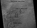
The crater's rim is cut with gullies. At the end of some gullies are fan-shaped deposits of material carried by water. The crater is very interesting to scientists because it has some of the best-exposed lake deposits. The Mars Reconnaissance Orbiter found that one of the layers contains clays.
Clays only form when water is present. Scientists suspect that a huge amount of water flowed through this area. One flow was caused by a body of water larger than Earth's Lake Huron. This happened when water burst through a crater rim that was blocking it. Holden is an old crater, with many smaller craters inside. Many of these are filled with sediment. Over 150 meters (490 ft) of sediment is visible in Holden Crater, especially in its southwestern part. The crater's central mountain is also covered by sediment. Much of this sediment likely came from river and lake deposits. Holden Crater is part of the Uzboi-Landon-Morava (ULM) outflow system.
Holden Crater's Geologic History
Studies of the region around Holden Crater have helped us understand a complex series of events. These events shaped the crater and included two different lakes. A large system of rivers called the Uzboi-Ladon-Morava (ULM) system drained water from the Argyre Basin, which held a large lake. When an impact created Holden Crater, its rim, almost a kilometer high, blocked this river system. Eventually, water from the crater walls, possibly with groundwater, collected to form the first lake. This lake was deep and lasted a long time. The lowest sedimentary rocks were deposited in this lake.
A lot of water was held back in Uzboi Vallis because Holden Crater's rim blocked its flow. Some of this backed-up water came from Nirgal Vallis. At one point, the stored water broke through Holden's rim. This created a second, shorter-lived lake that was 200–250 meters (650–820 ft) deep. Water at least 50 meters (160 ft) deep entered Holden at a rate 5–10 times that of the Mississippi River. Terraces and large rocks (tens of meters across) support these high flow rates.
Western Elysium Planitia Paleolake
There is evidence for a large lake in Western Elysium. However, some researchers think large lava flows could explain the terrain. The basin of this supposed lake covers more than 150 km2 (58 sq mi). It is covered with fractured plates and winding ridges that look like pack-ice on Earth. Sorted patterned ground and erosion patterns in polygonal terrain support the idea of ice-rich material, suggesting a lake. Also, streamlined islands, cataracts, and branching channel systems suggest formation by water from a lake.
Some surfaces here show "Rootless cones," which are mounds with pits. These can be caused by explosions when lava flows over ground rich in ice. The ice melts and turns into vapor, expanding in an explosion that creates a cone or ring. Features like these are found in Iceland when lava covers water-saturated ground. The western Elysium Planitia basin is almost perfectly flat. It slopes only about 10 meters (33 ft) over a 500 km (310 mi) distance. This is as level as Earth's ocean. This very gentle slope argues against it being a lava flow. In some places, the flow surface has been lowered by 50%. This is expected if the flow was water, but not if it were lava. The maximum depth of the lake was estimated to be between 31 and 53 meters (102 and 174 ft).
The Western Elysium Paleolake is in the southern part of the Elysium quadrangle. It is south of the Elysium volcanic field and near Cerberus Fossae. Scientists have suggested that the water for this ancient lake came from troughs in Cerberus Fossae. Several ideas explain how this happened, including groundwater discharge and a dike breaking through a frozen layer.
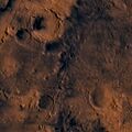
Argyre Basin's Giant Lake
The Argyre basin was created by a giant impact. This happened 70 million years after the Hellas impact. Scientists suspect it contained a lake early in Mars's history. The Argyre basin is in the Argyre quadrangle. At least three river valleys (Surius Vallis, Dzigal Vallis, and Palacopus Vallis) drain into it from the south. After the Argyre lake froze solid, the ice formed eskers, which are visible today.
An article written by 22 researchers in Icarus concluded that the impact that formed the Argyre basin likely hit an ice cap or a thick permafrost layer. Energy from the impact melted the ice and formed a giant lake. This lake eventually sent water to the North. The lake's volume was equal to Earth's Mediterranean Sea. The deepest part of the lake may have taken more than a hundred thousand years to freeze. But with heat from the impact, geothermal heating, and dissolved salts, it may have had liquid water for many millions of years. Life may have developed during this time. This region shows a lot of evidence of glacial activity. This includes flow features, crevasse-like fractures, drumlins, eskers, tarns, aretes, cirques, horns, U-shaped valleys, and terraces. Because of the shapes of Argyre's winding ridges, the authors concluded they are eskers.
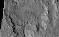
Ritchey Crater's Lake Evidence
Ritchey is a crater in the Coprates quadrangle. It is 79 km (49 mi) in diameter and was named after George W. Ritchey, an American astronomer. There is strong evidence that it was once a lake.
Ritchey Crater has been suggested as a landing site for a Mars Rover. A thick sequence of sedimentary deposits that include clay is found in the crater. Clay deposits indicate that water was probably present for a time. The presence of features along the crater wall and rim, as well as alluvial/fluvial deposits, support the idea of much water being present in the past.
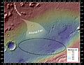
Jezero Crater and Perseverance

Estimations of the Jezero crater lake level as of 2021
|
|
| Diameter | 49.0 km (30.4 mi) |
|---|---|
| Eponym | Jezero, meaning "lake" in Slavic languages |
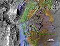
Jezero is a crater on Mars located at 18°51′18″N 77°31′08″E / 18.855°N 77.519°E in the Syrtis Major quadrangle. The crater is about 49.0 km (30.4 mi) across. Thought to have once been flooded with water, the crater contains a fan-delta deposit rich in clays.

Jezero crater, once considered a site for the Mars Science Laboratory, is the landing site for the Perseverance Mars rover. Clay minerals have been detected in and around the crater. The Mars Reconnaissance Orbiter identified smectite clays. Clays form when water is present, so this area probably once held water and maybe life in ancient times. The surface in places is cracked into polygonal patterns. Such shapes often form when clay dries out.
Researchers described in a paper, released in March 2015, how an ancient Martian lake system existed in Jezero Crater. The study suggested that water filled the crater at least two separate times. There are two channels on the northern and western sides of the crater that likely supplied it with water. Both of these channels have delta-like deposits near the landing site. Here, sediment was carried by water and deposited in the lake. Pictures show layers and meanders.
A main goal of the Mars 2020 mission is to search for signs of ancient life. Scientists hope that a later mission could then bring back samples from sites likely to contain remains of life. To safely land the craft, a 12 km (7.5 mi) wide, smooth, flat circular area was needed. Geologists want to examine places where water once collected. They are especially interested in sediment layers.
Studies of Jezero by the Perseverance rover allowed scientists to piece together the crater's history. This could also help understand other impact craters, as they may have gone through similar processes. After a large impact created Jezero Crater, hot magma moved and gathered underground. This formed intrusions called sills and dikes. Since rocks contained large crystals, scientists concluded that the magma cooled very slowly over a long time. Later erosion exposed these old chambers. Then, lava flowed into Jezero. The basalt that formed was detected by Perseverance. The rover also found carbonate minerals. These minerals meant that water came in and formed a lake. Just looking at satellite pictures of Jezero, one might guess that only minerals from sedimentary rocks would be found. However, several types of rocks were formed, indicating a complex history.
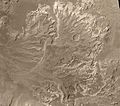
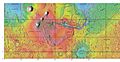
Eridania Lake: A Vast Ancient Sea
Eridania Lake is a theorized ancient lake with a surface area of roughly 1.1 million square kilometers (420,000 sq mi). Its maximum depth was 2,400 meters (7,900 ft), and its volume was 562,000 km3 (135,000 cu mi). It was larger than Earth's largest landlocked sea, the Caspian Sea. It held more water than all of North America's Great Lakes combined. The upper surface of the lake was likely at the elevation of the valley networks that surround it. These valleys all end at the same elevation, suggesting they emptied into a lake.
Three basins make up the lake: Ariadnes, Atlantis, and Gorgonum. It is located at the source of the Ma'adim Vallis outflow channel. It extends into the Eridania quadrangle and the Phaethontis quadrangle. As Eridania Lake dried out in the late Noachian epoch, it divided into smaller lakes. Clays, which need water to form, have been found within the borders of this supposed lake. They were identified as Mg/Fe-bearing phyllosilicates and Al-rich phyllosilicates, using hyperspectral data from CRISM.
Further study, published in 2016, used both OMEGA (Visible and Infrared Mineralogical Mapping Spectrometer on Mars Express) and CRISM. It found a capping layer above an Al-rich clay layer (likely Al-smectite and/or kaolins). Beneath this layer is Fe-rich clay, called nontronite smectite, and then a layer of zeolite or hydrated sulfate. Small deposits of alunite and jarosite were also discovered. These clay minerals provide good conditions for preserving traces of past Martian life.
Later research with CRISM found thick deposits, over 400 meters (1,300 ft) thick. These contained minerals like saponite, talc-saponite, Fe-rich mica (for example, glauconite-nontronite), Fe- and Mg-serpentine, Mg-Fe-Ca-carbonate, and probable Fe-sulphide. The Fe-sulphide likely formed in deep water heated by volcanoes. Such a process, called hydrothermal, may have been a place where life began. Saponite, talc, talc-saponite, nontronite, glauconite, and serpentine are all common on Earth's seafloors. The earliest evidence of life on Earth appears in seafloor deposits similar to those found in the Eridania basin. So, samples from Eridania may give us clues about early Earth's environment. Chloride deposits were found where a shoreline existed. They were deposited as water evaporated from the sea. These chloride deposits are thought to be thin (less than 30 meters (98 ft)). This is because some craters do not show the chemical in their ejecta (material thrown out by impact). A crater's ejecta contains material from under the surface. If the chloride deposits were very deep, they would have appeared in the ejecta.
At a 2018 planetary science conference in Texas, a paper suggested that the deep waters of Eridania Lake may have hosted ancient life. This environment was rich in energy and chemical nutrients. The earliest evidence of life on Earth is similar to this type of deep-sea environment. So, Eridania could offer insights into how life began.
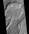
Columbus Crater's Evaporating Lake

Columbus crater based on THEMIS day-time image
|
|
| Planet | Mars |
|---|---|
| Diameter | 119 km |
| Eponym | Christopher Columbus, Italian explorer (1451–1506) |
Columbus Crater is a crater in the Memnonia quadrangle. It is 119 km (74 mi) in diameter and was named after Christopher Columbus. Research with an orbiting near-infrared spectrometer found evidence of layers of both clay and sulfates in Columbus crater. This instrument reveals mineral types based on the light they absorb. This finding is exactly what would appear if a large lake had slowly evaporated. Moreover, some layers contained gypsum, a sulfate that forms in relatively fresh water. This means life could have formed in the crater.
The CRISM instrument on the Mars Reconnaissance Orbiter found kaolinite and hydrated sulfates, including alunite and possibly jarosite. Further study concluded that gypsum, polyhydrated and monohydrated Mg/Fe-sulfates were common. Small deposits of montmorillonite, Fe/Mg-phyllosilicates, and crystalline ferric oxide or hydroxide were also found. Thermal emission spectra suggest that some minerals were present in significant amounts. These minerals strongly suggest that water was present in the crater.
Scientists are excited about finding hydrated minerals like sulfates and clays on Mars. This is because they usually form when water is present. Places that contain clays and/or other hydrated minerals would be good places to look for signs of life. Sulfate minerals were found above aluminum-rich clays. This implies that early on, when the clays formed, the water was more neutral. This would have been easier for life to develop. Sulfates usually form in more acidic waters.
Navua Valles channels northeast of the Hellas Basin may have also hosted a large, ice-covered lake in the past.
Southern Polar Cap Subglacial Lake

In 2018, scientists announced the discovery of a subglacial lake below Mars's south polar ice cap. The lake was detected by the Mars Express orbiter. It is 20 km (12 mi) long and lies under about 1.5 km (0.93 mi) of glacial ice. The water temperature is estimated to be -68°C (-90°F), and it is an extremely salty brine.
In September 2020, scientists confirmed the existence of several large saltwater lakes under the ice in Mars's south polar region. According to one of the researchers, "We identified the same body of water [as suggested earlier], but we also found three other bodies of water around the main one... It's a complex system."
Images for kids
-
A possible delta in Margaritifer Sinus quadrangle, as seen by THEMIS.
-
A probable delta in Eberswalde Crater, northeast of Holden Crater. Seen by Mars Global Surveyor in Margaritifer Sinus quadrangle.
-
A delta in Lunae Palus quadrangle, as seen by THEMIS.
-
A delta filling a crater in Lunae Palus quadrangle, as seen by HiRISE.
-
The Jezero crater delta, showing changes made by water.
-
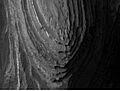
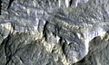
Layers in Terby crater may have formed when the Hellas basin was filled with water.
-
Northern part of Terby Crater showing many layers, as seen by CTX camera (on Mars Reconnaissance Orbiter). Parts of this image are enlarged in next two images.
-

Northern part of Terby Crater showing many layers, as seen by CTX camera (on Mars Reconnaissance Orbiter).
-
Northern part of Terby Crater showing many layers, as seen by CTX camera (on Mars Reconnaissance Orbiter).
-
MOLA maps showing the geographic context of Argyre.
-
MOLA map showing boundaries for Argyre Planitia and other regions.
-
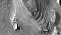
Scene in Argyre quadrangle with gullies, alluvial fans, and hollows, as seen by HiRISE. Enlargements of parts of this image are below.
-
Several levels of alluvial fans, as seen by HiRISE. Locations of these fans are indicated in the previous image. Fans are formed with the action of water.
-
Small, well-formed alluvial fan, as seen by HiRISE. Location of this fan is shown in an image displayed above. Water is involved with fan formation.
-
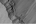
Layers in the canyon wall in Coprates, as seen by Mars Global Surveyor.
-
Hellas Basin Area topography. Crater depth is 7,152 meters (23,000 ft) below Mars's standard elevation level.
-
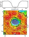
Hellas Basin with a graph showing the great depth of the crater. It is the deepest crater on Mars and has the highest surface pressure.
-
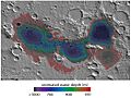
Map showing estimated water depth in different parts of Eridania Sea. This map is about 530 miles across.
-
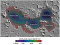
Features around Eridania Sea labeled.
-
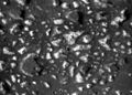
Columbus Crater Layers, as seen by HiRISE. This false-color image is about 800 feet across. Some of the layers contain hydrated minerals.
-
Deep-basin deposits from the floor of Eridania Sea. The mesas on the floor are there because they were protected against intense erosion by deep water/ice cover. CRISM measurements show minerals may be from seafloor hydrothermal deposits. Life may have originated in this sea.
-
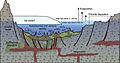
Diagram showing how volcanic activity may have caused deposition of minerals on the floor of Eridania Sea. Chlorides were deposited along the shoreline by evaporation.
-
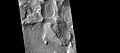
Western side of Ritchey Crater, as seen by CTX camera (on Mars Reconnaissance Orbiter).
-
Fan along western wall of Ritchey Crater, as seen by CTX camera (on Mars Reconnaissance Orbiter). Note: this is an enlargement of previous image.
-
Troughs of the Cerberus Fossae group, as seen by HiRISE.
-
A portion of a trough (fossa) in Elysium, as seen by HiRISE. This is an enlargement of a previous image. Troughs are part of the Cerberus Fossae group.
-
Viking 1 Orbiter
-
Close-up of Channels on Rim of Holden Crater, as seen by THEMIS. Image is located in the Margaritifer Sinus quadrangle.
-
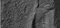
Hole (1.6 cm (0.63 in)) drilled into "John Klein" mudstone.
-

Spectral Analysis (SAM) of "Cumberland" mudstone.
-
The Curiosity rover examines mudstone near Yellowknife Bay on Mars (May 2013).
-
Peace Vallis and related alluvial fan near the Curiosity landing ellipse and landing site (noted by +).
-
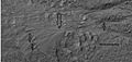
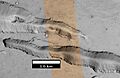
"Hottah" rock outcrop on Mars – an ancient streambed viewed by Curiosity (September 14, 2012)
-
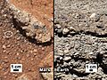
"Link" rock outcrop on Mars – compared with a terrestrial fluvial conglomerate – suggesting water "vigorously" flowing in a stream.


See also
- Atmosphere of Mars
- Composition of Mars
- Evidence of water on Mars found by Mars Reconnaissance Orbiter
- Extraterrestrial liquid water
- Geological history of Mars
- Geology of Mars
- Groundwater on Mars
- Lakes of Titan
- Life on Mars
- List of craters on Mars
- Outflow channels
- Perseverance (rover)
- Syrtis Major quadrangle
- Valley network (Mars)
- Seasonal flows on warm Martian slopes
- Water on Mars
