
Water on Mars facts for kids

Today, most of the water on Mars is frozen as ice at the poles and deep underground. A tiny bit also floats around as vapor in the air. Scientists once thought that dark streaks seen on Martian slopes, called recurrent slope lineae, might be salty liquid water flowing. But now, they believe these streaks are more likely just sand and dust sliding downhill.
Even though most water ice is hidden, you can see it in some places on Mars. In the middle parts of the planet, it shows up in impact craters, steep cliffs, and gullies. You can also see water ice at the north polar ice cap. There's also a lot of water ice under the permanent carbon dioxide ice cap at the south pole. Scientists have found over 5 million cubic kilometers of ice near the surface. That's enough to cover the whole planet with water about 35 meters deep! There might be even more ice buried deeper down.
Today, liquid water can only exist on Mars for very short times, like tiny bits of moisture from the air or thin films. These are very tough places for life to survive. This is because Mars has very low air pressure. If ice gets warm on the surface, it turns directly into gas (this is called sublimation) very quickly.
Billions of years ago, around 3.8 billion years ago, Mars might have had a thicker atmosphere and warmer temperatures. This could have allowed a lot more liquid water on its surface, maybe even a huge ocean covering a third of the planet! Water also seems to have flowed on the surface for short times more recently. The area called Aeolis Palus in Gale Crater, explored by the Curiosity rover, was once an ancient freshwater lake. This lake could have been a good place for tiny living things (microbes).
Scientists figure out how much water is on Mars today by looking at images from spacecraft, using special tools like spectrometers and radar, and by studying the surface with landers and rovers. Evidence of past water includes huge channels carved by floods, old river valleys, deltas, and lakebeds. They also find rocks and minerals that could only have formed in liquid water. Many land features suggest there's ice underground (called permafrost) and that ice has moved like glaciers, both recently and in the past. Gullies and slope lineae on cliffs and crater walls suggest that flowing water still shapes Mars' surface, but much less than in the ancient past.
Even though Mars' surface was wet and might have supported tiny life forms billions of years ago, it's now very dry and super cold. This makes it very hard for living things to survive. Also, Mars doesn't have a thick atmosphere, an ozone layer, or a strong magnetic field like Earth. This means harmful solar and cosmic radiation hits the surface directly. This radiation can damage living cells, making it hard for life to survive on the surface. So, the best places to look for life on Mars might be deep underground.
Scientists have found huge amounts of underground ice on Mars, enough to fill Lake Superior. In 2018, they thought they found a lake of liquid water under the ice at the south pole, about 1.5 kilometers deep and 20 kilometers wide. This would have been the first stable liquid water found on Mars. However, later studies have questioned if this was really a lake.
Knowing where and how much water is on Mars is super important. It helps us figure out if the planet could have life and if it has resources for future human explorers. That's why NASA's Mars Exploration Program (MEP) in the early 2000s had the theme "Follow the Water." Missions like 2001 Mars Odyssey, Mars Express, Mars Exploration Rovers (MERs), Mars Reconnaissance Orbiter (MRO), and the Mars Phoenix lander have all given us information about water on Mars. Many of these missions are still working and making new discoveries! In September 2020, scientists confirmed several large salty lakes under the ice in the south polar region. One researcher said they found the same lake as before, plus three others around it, calling it a "complex system." In March 2021, researchers reported that a lot of ancient Martian water is still there, but it's mostly locked away in the planet's rocks and crust. In August 2024, data from NASA's InSight Mars Lander suggested a liquid water reservoir 10-20 kilometers deep under the Martian crust.
Contents
How We Learned About Water on Mars
Early Ideas About Water
People have wondered about water on Mars for hundreds of years, even before we sent spacecraft there. Early astronomers using telescopes saw white polar caps and clouds. They correctly guessed these were signs of water. Because Mars also has a 24-hour day, astronomer William Herschel said in 1784 that Mars probably had conditions "similar to ours" for its inhabitants.


By the early 1900s, most astronomers knew Mars was much colder and drier than Earth. They no longer believed in oceans. Instead, Mars was seen as a "dying" planet with very little water. Dark areas that changed with the seasons were thought to be plants. Percival Lowell (1855–1916) made this idea popular. He imagined Martians building a network of canals to move water from the poles to people living near the equator. While many people found this exciting, most astronomers didn't agree. A famous astronomer, Edward Walter Maunder, compared Mars' climate to a very cold, high mountain on an arctic island where only tiny plants like lichen could survive.
Meanwhile, astronomers tried to figure out what Mars' atmosphere was made of using spectroscopy. Between 1925 and 1943, scientists tried to find oxygen and water vapor but mostly failed. The only gas they were sure about was carbon dioxide (CO2), found in 1947. Water vapor wasn't clearly found on Mars until 1963.

For a long time, people thought the polar caps were water ice. But some scientists in the late 1800s thought they might be CO2 ice because Mars was so cold and seemed to lack water. This idea was proven in 1966. Today, we know the winter caps at both poles are mostly CO2 ice. But in summer, a permanent cap of water ice remains at the north pole. At the south pole, a small CO2 ice cap stays in summer, but it also has water ice underneath.
The Mariner 4 spacecraft in 1965 gave us the final piece of the puzzle. Its blurry pictures showed a surface full of impact craters. This meant the surface was very old and hadn't been changed much by erosion or tectonic activity like on Earth. Little erosion meant liquid water probably hadn't played a big role for billions of years. Also, signals from the spacecraft showed the atmosphere was less than 1% as thick as Earth's. This low pressure meant liquid water would quickly boil or freeze. So, Mars was seen as a world like the Moon, but with a tiny bit of air to blow dust around. This view lasted for almost ten years until Mariner 9 showed a much more active Mars, hinting that its past was wetter than its present.
On January 24, 2014, NASA announced that the Curiosity and Opportunity rovers were looking for signs of ancient life on Mars. This included searching for tiny organisms that make their own food, and for ancient water, especially in areas that used to be rivers or lakes, which might have been good places for life.
For many years, scientists thought huge floods on Mars came from a global underground water source. But research in 2015 showed that regional deposits of sediment and ice, formed 450 million years earlier, were the source. These sediments from rivers and melting glaciers filled giant canyons under an ancient ocean in Mars' northern lowlands. Water trapped in these canyon sediments was later released in huge floods, whose effects we can still see today.
Clues from Rocks and Minerals
Scientists widely agree that Mars had a lot of water very early in its history. But all large areas of liquid water have since disappeared. Some of this water is still on Mars today as ice, and some is locked inside water-rich materials like clay minerals and sulfates. Studies of hydrogen in Mars' water suggest that asteroids and comets brought it to Mars. The total amount of water on Mars today is about 6% to 27% of Earth's current ocean.
Water in Weathered Rocks
The main type of rock on Mars' surface is basalt. This is a fine-grained rock made of minerals like olivine, pyroxene, and plagioclase feldspar. When these minerals are exposed to water and gases in the air, they change into new minerals. Some of these new minerals can hold water inside their structure, either as H2O or as hydroxyl (OH). Examples of these "hydrated" minerals found on Mars include goethite (found in Earth's soils), gypsum, kieserite, opaline silica, and phyllosilicates (like kaolinite and montmorillonite).
When rocks chemically weather, they use up water and other chemicals, taking them from the atmosphere and water sources and storing them in rocks and minerals. We don't know how much water is stored in Mars' crust as hydrated minerals, but it could be a lot. For example, studies of rocks found by the Opportunity rover suggest that the sulfate deposits there could contain up to 22% water by weight.
On Earth, all chemical weathering involves water. Some minerals don't actually hold water, but they still need water to form. Examples include many carbonates, some sulfates, and iron oxides like hematite. On Mars, some of these might form with very little water, perhaps just as ice or thin films. Scientists are still figuring out how much these "exotic" weathering processes happen on Mars. Minerals that contain water or need water to form are generally called "aqueous minerals."
Aqueous minerals tell us a lot about the environment where they formed. How easily these reactions happen depends on pressure, temperature, and the amount of gases and dissolved substances. Two important factors are pH (how acidic or basic the water is) and oxidation-reduction potential (Eh). For example, the sulfate mineral jarosite only forms in very acidic water. Phyllosilicates usually form in neutral to basic water. Eh tells us about the oxidation state of the water. Together, Eh and pH show which minerals are most likely to form. So, by looking at the minerals in Martian rocks, we can guess what the past environment was like, including if it was good for life.
Hot Water Underground (Hydrothermal Alteration)
Aqueous minerals can also form underground when hot water (called hydrothermal fluids) moves through cracks in rocks. The heat for these systems can come from nearby magma or from the leftover heat of large impacts. On Earth, one important type of hydrothermal change in the ocean floor is called serpentinization. This happens when seawater moves through certain rocks. The water reacts with the rocks, producing hydrogen gas (H2). This process creates a very basic and reducing environment, which helps form certain phyllosilicates and carbonate minerals. The hydrogen gas can be an energy source for tiny organisms or react with CO2 to make methane gas. This is a possible non-biological source for the small amounts of methane found in Mars' atmosphere. Serpentine minerals can also store a lot of water in their structure. One study suggests that ancient serpentinites in Mars' highlands could hold enough water to cover the planet with a 500-meter-deep layer. While some serpentine minerals have been found on Mars, we haven't seen large areas of them from space. This doesn't mean they aren't hidden deep underground.
How Fast Rocks Change
The speed at which primary minerals change into secondary aqueous minerals varies. Primary silicate minerals form from hot magma deep underground, under very high pressures and temperatures. When they are exposed to the surface, they are out of balance and will react with available chemicals to form more stable minerals. Generally, minerals that form at the highest temperatures weather the fastest. On Earth and Mars, olivine is a common example. It easily changes into clay minerals when water is present. Olivine is found all over Mars, which suggests that Mars' surface hasn't been completely changed by water. However, a lot of other geological evidence suggests otherwise.
Martian Meteorites

Over 60 meteorites found on Earth have come from Mars. Some of them show signs that they were exposed to water when they were on Mars. Some Martian meteorites, called basaltic shergottites, seem to have been exposed to liquid water before they were blasted into space. Another group of meteorites, the nakhlites, were soaked with liquid water about 620 million years ago. They were thrown from Mars about 10.75 million years ago by an asteroid impact and landed on Earth within the last 10,000 years. The Martian meteorite NWA 7034 has ten times more water than most other Martian meteorites. It's similar to the basalts studied by rovers and formed during the early Amazonian epoch.
In 1996, some scientists reported possible tiny fossils in the Allan Hills 84001 meteorite from Mars. Many studies disagreed, mainly because the shapes of these supposed fossils could be explained by other things. It was also found that most of the organic material in the meteorite came from Earth. Scientists now agree that shape alone isn't enough to prove primitive life. Interpreting shapes can be tricky and has led to many mistakes.
Land Features Showing Water's Past
Lakes and River Valleys
The Mariner 9 spacecraft in 1971 completely changed our understanding of water on Mars. It found huge river valleys in many areas. Pictures showed that floods broke through natural dams, carved deep valleys, eroded grooves into solid rock, and traveled thousands of kilometers. Areas with branched streams in the southern hemisphere suggested that rain once fell.

The number of known valleys has grown over time. Research in 2010 mapped 40,000 river valleys on Mars, four times more than previously identified! Martian water-carved features fall into two main types:
- 1) Branching, Earth-sized valley networks from the ancient Noachian period.
- 2) Exceptionally large, long, single outflow channels from the later Hesperian period.
Recent work also suggests there might be smaller, younger channels in the mid-latitudes, perhaps linked to occasional melting of ice deposits.
Some parts of Mars show "inverted relief." This happens when sediments are laid down on a stream bed and then become hard, maybe by minerals cementing them. Later, the area might get buried. Eventually, erosion removes the top layers, and the old stream beds become visible because they are harder than the surrounding land. The Mars Global Surveyor found several examples of this. Many inverted streams have been found in places like the Medusae Fossae Formation, Miyamoto Crater, Saheki Crater, and the Juventae Plateau.

Many lake basins have been found on Mars. Some are as big as Earth's largest lakes, like the Caspian Sea. Lakes fed by valley networks are found in the southern highlands. There are closed low areas with river valleys leading into them. These are thought to have once held lakes. One is in Terra Sirenum, whose overflow went through Ma'adim Vallis into Gusev Crater, explored by the Mars Exploration Rover Spirit. Another is near Parana Valles and Loire Vallis. Some lakes are thought to have formed from rain, while others formed from underground water. Lakes probably existed in the Argyre basin, the Hellas basin, and maybe in Valles Marineris. It's likely that many craters held lakes during the Noachian period. These lakes suggest a cold, dry environment, similar to the Great Basin in the western USA during the last Ice Age on Earth.
Research from 2010 suggests Mars also had lakes near the equator. While earlier studies showed Mars had a warm, wet early history that later dried up, these lakes existed in the Hesperian Epoch, a much later time. Using detailed images from NASA's Mars Reconnaissance Orbiter, researchers think there might have been more volcanic activity, meteorite impacts, or changes in Mars' orbit during this period. These events could have warmed Mars' atmosphere enough to melt the abundant ice in the ground. Volcanoes would have released gases that thickened the atmosphere temporarily, trapping more sunlight and making it warm enough for liquid water. In this study, channels were found connecting lake basins near Ares Vallis. When one lake filled up, its water overflowed and carved channels to a lower area where another lake would form. These dry lakes would be good places to look for signs of past life.
On September 27, 2012, NASA scientists announced that the Curiosity rover found direct evidence of an ancient streambed in Gale Crater. This suggested a "vigorous flow" of water on Mars. Analysis of the dry streambed showed the water flowed at about 3.3 kilometers per hour, possibly hip-deep. Proof of running water came from rounded pebbles and gravel that could only have been worn smooth by strong water currents. Their shape and position suggested they traveled a long way from above the crater rim, where a channel called Peace Vallis feeds into the area.
Eridania Lake is a theoretical ancient lake that covered about 1.1 million square kilometers. It was up to 2,400 meters deep and held 562,000 cubic kilometers of water. This was larger than the largest landlocked sea on Earth, the Caspian Sea, and held more water than all other Martian lakes combined. It held over nine times as much water as all of North America's Great Lakes. The top of the lake was thought to be at the same height as the surrounding valley networks, suggesting they emptied into it. Research on this basin found thick deposits, over 400 meters deep, containing minerals like saponite, talc-saponite, iron-rich mica, serpentine, carbonate, and probable iron-sulfide. The iron-sulfide likely formed in deep water heated by volcanoes. This process, called hydrothermal, might be where life on Earth began.
-
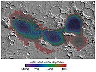
Map showing estimated water depth in different parts of Eridania Sea. This map is about 530 miles across.
-
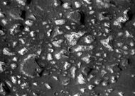
Deep-basin deposits from the floor of Eridania Sea. The flat-topped hills (mesas) on the floor are there because deep water/ice protected them from erosion. CRISM measurements show minerals that might be from seafloor hydrothermal deposits.
-
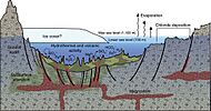
Diagram showing how volcanic activity might have caused minerals to be deposited on the floor of Eridania Sea. Chlorides were left along the shoreline as water evaporated.


Lake Deltas

Researchers have found many examples of deltas that formed in Martian lakes. Finding deltas is a big sign that Mars once had a lot of liquid water. Deltas usually need deep water for a long time to form. Also, the water level needs to be steady so that sediment isn't washed away. Deltas have been found across a wide area, though some seem to be grouped around the edges of the supposed ancient northern ocean of Mars.
Underground Water (Groundwater)

By 1979, scientists thought that huge outflow channels formed from single, sudden bursts of underground water, possibly sealed by ice. These bursts would have released massive amounts of water across an otherwise dry Martian surface. Also, evidence for huge floods is seen in the giant ripples in the Athabasca Vallis. Many outflow channels start at Chaos or Chasma features, which supports the idea of a sudden break that could have released underground ice.
The branching valley networks on Mars don't fit with the idea of sudden, huge releases of groundwater. Their branching shapes don't come from a single outflow point, and the amount of water that flowed through them seems different. Instead, some scientists argue that they formed from slow seeping of groundwater from underground, like springs. To support this, the upstream ends of many valleys in these networks start with "box canyon" or "amphitheater" heads. On Earth, these are usually linked to groundwater seeping out. There's also little evidence of smaller channels at the very tips of these valleys. Some scientists think this means the water appeared suddenly from underground with a lot of flow, rather than slowly building up on the surface. Others disagree, saying the lack of small channels might be due to erosion or impacts. Most scientists agree that groundwater played at least some role in shaping most valley networks.

Underground water also played a key role in how sediments were laid down on Mars. According to this idea, groundwater with dissolved minerals came to the surface, in and around craters. It helped form layers by adding minerals, especially sulfate, and cementing sediments. In other words, some layers might have formed when groundwater rose, deposited minerals, and hardened existing loose, wind-blown sediments. These hardened layers would then be more protected from erosion. A 2011 study using data from the Mars Reconnaissance Orbiter showed that similar sediments exist in a large area including Arabia Terra. It's been suggested that areas rich in sedimentary rocks are also those most likely to have had regional groundwater rising to the surface.
In February 2019, European scientists found geological evidence of an ancient planet-wide underground water system. They argued it was connected to a huge ocean. In September 2019, researchers reported that the InSight lander found strange magnetic pulses and oscillations. These were consistent with a planet-wide reservoir of liquid water deep underground.
The Mars Ocean Idea

The Mars ocean idea suggests that the Vastitas Borealis basin in the north was covered by an ocean of liquid water at least once. This ocean might have covered almost a third of Mars' surface early in the planet's history. This ocean, called Oceanus Borealis, would have filled the Vastitas Borealis basin, which is 4-5 kilometers lower than the average planetary elevation. Scientists have suggested two main ancient shorelines: a higher one, from about 3.8 billion years ago when the valley networks formed in the Highlands, and a lower one, possibly linked to younger outflow channels. The higher one, the 'Arabia shoreline', can be traced all around Mars except through the Tharsis volcanic region. The lower one, the 'Deuteronilus', follows the Vastitas Borealis formation.
A study in June 2010 concluded that the older ocean would have covered 36% of Mars. Data from the Mars Orbiter Laser Altimeter (MOLA), which measures the height of all terrain on Mars, was used in 1999 to figure out that the area that would have drained into such an ocean covered about 75% of the planet. Early Mars would have needed a warmer climate and thicker atmosphere for liquid water to exist on the surface. Also, the large number of valley networks strongly supports the idea that Mars had a water cycle in the past.
The idea of an ancient Martian ocean is still debated among scientists. Some features thought to be 'ancient shorelines' have been questioned. One problem with the suggested 2-billion-year-old shoreline is that it's not flat. This could be due to changes in Mars' mass, perhaps from volcanic eruptions or meteor impacts. The Elysium volcanic region or the huge Utopia basin buried under the northern plains are thought to be possible causes.
In March 2015, scientists said there was evidence for an ancient Martian ocean, likely in the northern hemisphere, about the size of Earth's Arctic Ocean (around 19% of Mars' surface). This finding came from comparing the ratio of water and deuterium in Mars' modern atmosphere to that on Earth. Mars had eight times more deuterium than Earth, suggesting ancient Mars had much more water. Results from the Curiosity rover had also found a high deuterium ratio in Gale Crater, though not high enough to suggest an ocean. Other scientists warn that this new study hasn't been fully confirmed. They point out that Martian climate models haven't yet shown the planet was warm enough in the past to support large bodies of liquid water.
More evidence for a northern ocean came out in May 2016. It described how some of the surface in the Ismenius Lacus region was changed by two tsunamis. These tsunamis were caused by asteroids hitting the ocean. Both were thought to be strong enough to create 30-kilometer-wide craters. The first tsunami picked up and carried huge boulders, the size of cars or small houses. The water flowing back formed channels by moving the boulders around. The second tsunami happened when the ocean was 300 meters lower. This one carried a lot of ice, which was dropped in valleys. Calculations show that the waves would have been about 50 meters high on average, but could range from 10 to 120 meters. Simulations show that in this part of the ocean, two impact craters 30 km wide would form every 30 million years. This suggests a large northern ocean might have existed for millions of years. One argument against an ocean has been the lack of shoreline features. These features might have been washed away by these tsunami events. The areas studied were Chryse Planitia and northwestern Arabia Terra. These tsunamis affected parts of the Ismenius Lacus and Mare Acidalium quadrangle regions.
In July 2019, more support for an ancient ocean on Mars was reported. It might have been formed by a possible mega-tsunami from a meteorite impact that created Lomonosov crater.
In January 2022, a study about Mars' climate 3 billion years ago showed that an ocean could have been stable with a closed water cycle. They estimated that water would return from icy highlands to the ocean as glaciers, but less than on Earth during its last ice age. This simulation included ocean circulation for the first time, showing it would prevent the ocean from freezing. These simulations also match observed land features identified as ancient glacial valleys.
Signs of Recent Flows
.gif)


Pure liquid water cannot exist stably on Mars' surface today because of the low air pressure and cold temperatures; it would boil away or freeze. So, a mystery began in 2006 when images from NASA's Mars Reconnaissance Orbiter showed gully deposits that weren't there ten years before. These might have been caused by flowing salty liquid water (brine) during Mars' warmest months. The images of two craters in Terra Sirenum and Centauri Montes seemed to show flows (wet or dry) on Mars between 1999 and 2001.
Scientists disagree about whether gullies are formed by liquid water. Some believe most gullies are formed by liquid water from melting snow or ice. Others think gullies are formed by dry flows, possibly helped by sublimating carbon dioxide (dry ice) from the Martian atmosphere.
Some studies argue that gullies forming in the southern highlands couldn't be made by water because conditions aren't right. The low pressure, cold, non-geothermal regions wouldn't allow liquid water at any time of year. But they would be ideal for solid carbon dioxide. The carbon dioxide melting in the warmer summer would then form the gullies. Even if gullies are carved by flowing water, the exact source of the water and how it moves are still unknown.
In August 2011, NASA announced the discovery of current seasonal changes on steep slopes below rocky outcrops near crater rims in the Southern Hemisphere. These dark streaks, now called recurrent slope lineae (RSL), grew downhill during the warmest part of the Martian summer. Then they slowly faded through the rest of the year, reappearing each year. Researchers suggested these marks were consistent with salty water (brines) flowing downhill and then evaporating, possibly leaving a residue. The CRISM instrument later directly observed hydrated salts appearing at the same time as these RSL, confirming in 2015 that these streaks are made by liquid brines flowing through shallow soil. The streaks contain hydrated chlorate and perchlorate salts, which contain liquid water molecules. The streaks flow downhill in Martian summer when the temperature is above -23°C. However, the source of this water is still unknown. But neutron spectrometer data from the Mars Odyssey orbiter, collected over a decade, showed no evidence of water (hydrogenated soil) at these active sites. So, its authors also support the ideas of either very short-lived atmospheric water vapor dissolving salts, or dry granular flows. They conclude that liquid water on Mars today might be limited to tiny bits of dissolved moisture from the atmosphere and thin films, which are very challenging places for life as we know it.
Another idea is a "Knudsen pump effect," from photophoretic forces when shadows occur in granular material. The scientists showed that the RSLs stopped at a 28° angle in Garni crater, which matches dry granular avalanches. Also, they pointed out problems with the "wet" idea, such as the water detection being only indirect (salt detection, not water itself).
Water on Mars Today


A lot of hydrogen (a part of water) has been seen globally by the Mars Odyssey neutron spectrometer and gamma ray spectrometer, and the Mars Express High Resolution Stereo Camera (HRSC). This hydrogen is thought to be part of water ice. By calculating, scientists have turned these measurements into amounts of water ice in the top meter of Mars' surface. This shows that ice is widespread and abundant today. Below 60 degrees latitude, ice is found in several areas, especially around the Elysium volcanoes, Terra Sabaea, and northwest of Terra Sirenum. It can be up to 18% ice in the subsurface. Above 60 degrees latitude, ice is very abundant. Beyond 70 degrees latitude, ice makes up over 25% almost everywhere, and nearly 100% at the poles. The SHARAD and MARSIS radar instruments have also confirmed that individual surface features are rich in ice. Because ice is unstable at Mars' current surface conditions, almost all this ice is thought to be covered by a thin layer of rock or dust.
The Mars Odyssey neutron spectrometer observations suggest that if all the ice in the top meter of Mars' surface were spread evenly, it would create a global layer of water at least 14 centimeters deep. This means the average Martian surface is about 14% water. The water ice currently locked in both Martian poles would make a 30-meter global layer. Geological evidence suggests much larger amounts of surface water existed in Mars' history, possibly up to 500 meters deep. Some of this past water is thought to have been lost deep underground, and some to space. The current amount of water in the atmosphere is small (less than 10 micrometers deep if spread globally), but it helps move ice from one part of the surface to another over seasons and longer times.
It's possible that liquid water could also exist on Mars' surface as brines, which are salty water solutions. Brines are important on Mars because they can stay liquid at much lower temperatures than pure water. Pure liquid water is unstable on Mars' surface because it freezes, evaporates, and boils. Just like salt is used on Earth's roads to prevent ice, salty water mixtures on Mars might have low enough freezing points to stay liquid on the surface. The complex mix of salts in Mars' soil (called regolith) can change how stable brines are. Scientists can model how these salt mixtures absorb moisture from the air (deliquescence) to see if liquid brines are present. The composition of Mars' regolith, found by the Phoenix lander, helps make these models accurate. Results show that at temperatures between -65°C and -20°C, chlorate salts have the lowest "water activity" values, meaning they are the most stable brines. Below -65°C, chloride salts are most stable. However, these complex salt mixtures don't significantly increase brine stability, suggesting that brines might not be a major source of liquid water on Mars' surface.
Ice Caps at the Poles

We've known about ice in Mars' northern (Planum Boreum) and southern (Planum Australe) polar caps since the Mariner 9 orbiter. But we didn't know how much or how pure this ice was until the early 2000s. In 2004, the MARSIS radar on the European Mars Express satellite confirmed that the south polar ice cap has relatively clean ice that goes down 3.7 kilometers below the surface. Similarly, the SHARAD radar on the Mars Reconnaissance Orbiter saw the base of the north polar cap 1.5-2 kilometers deep. Together, the amount of ice in Mars' north and south polar caps is similar to the Greenland ice sheet on Earth.

An even larger ice sheet in the south polar region is thought to have shrunk in ancient times (the Hesperian period). It might have held 20 million cubic kilometers of water ice, enough to cover the entire planet with a 137-meter-deep layer.
Both polar caps show many layers of ice and dust when seen in images of the spiral-shaped troughs that cut through them. Underground radar measurements show these layers continue across the ice sheets. These layers hold a record of Mars' past climates, just like Earth's ice sheets record its climate. Reading this record is tricky, but many researchers study these layers to understand the caps' structure, history, and how they flow, as well as Mars' climate evolution.
Around the polar caps are many smaller ice sheets inside craters. Some are under thick layers of sand or Martian dust. For example, the 81.4-kilometer-wide Korolev Crater is estimated to contain about 2200 cubic kilometers of water ice exposed at the surface. Korolev's floor is about 2 kilometers below the rim and is covered by a 1.8-kilometer-deep central mound of permanent water ice, up to 60 kilometers in diameter.
Liquid Water Under the Ice

Scientists thought there might be lakes under the ice on Mars after studying Lake Vostok in Antarctica. In July 2018, scientists from the Italian Space Agency reported finding such a subglacial lake on Mars, 1.5 kilometers below the southern polar ice cap. It stretched about 20 kilometers wide, making it the first evidence of a stable body of liquid water on the planet. This Martian lake was found from a bright spot in the radar data from the MARSIS radar on the European Mars Express orbiter, collected between 2012 and 2015. The lake is centered at 193°E, 81°S, a flat area with no special features but surrounded by higher ground, except on its east side where there's a dip. The SHARAD radar on NASA's Mars Reconnaissance Orbiter hasn't seen any sign of the lake. SHARAD is designed for higher detail but can't see as deep. So, if the ice above the lake has a lot of rocky material, SHARAD might not be able to detect it.
On September 28, 2020, the MARSIS discovery was confirmed using new data and a new analysis technique. These new radar studies reported three more underground lakes on Mars. All are 1.5 kilometers below the southern polar ice cap. The size of the first lake found, and the largest, was corrected to 30 kilometers wide. It's surrounded by 3 smaller lakes, each a few kilometers wide.
.jpg)
Because the temperature at the bottom of the polar cap is estimated to be -68°C, scientists think the water might stay liquid because of the antifreeze effect of magnesium and calcium perchlorates (salts). The 1.5-kilometer ice layer covering the lake is made of water ice with 10-20% dust mixed in, and it's seasonally covered by a 1-meter-thick layer of CO2 ice. Since the raw data coverage of the south polar ice cap is limited, the discoverers said there's "no reason to conclude that the presence of subsurface water on Mars is limited to a single location."
In 2019, a study explored the conditions needed for such a lake to exist. It calculated the amount of heat from inside Mars needed to reach temperatures where liquid water and perchlorate mix would be stable under the ice. The authors concluded that "even if there are local concentrations of large amounts of perchlorate salts at the base of the south polar ice, typical Martian conditions are too cold to melt the ice... a local heat source within the crust is needed to increase the temperatures, and a magma chamber within 10 km of the ice could provide such a heat source. This result suggests that if the liquid water interpretation of the observations is correct, volcanism on Mars may have been active extremely recently."
China's Zhurong rover, which studied the Utopia Planitia region of Mars, found a shift in sand dunes around the same time that layers in the North polar region changed. Researchers believe that Mars' tilt changed at that time, causing changes in the winds at Zhurong's landing site and in the ice cap layers.
If a liquid lake does exist, its salty water might also be mixed with soil to form a sludge. The lake's high salt levels would make it difficult for most life forms. On Earth, organisms called halophiles thrive in extremely salty conditions, though not in dark, cold, concentrated perchlorate solutions. However, organisms that can tolerate salt might be able to handle high perchlorate levels by using adaptations similar to those seen in the yeast Debaryomyces hansenii when exposed to increasing salt concentrations in lab experiments.
Ice in the Ground
For many years, scientists have suggested that some Martian surfaces look like "periglacial" regions on Earth, which are areas with frozen ground. By comparing them, they've argued that these might be regions of permafrost, meaning frozen water lies just beneath the surface. A common feature in higher latitudes, patterned ground, can appear as stripes and polygons. On Earth, these shapes are caused by soil freezing and thawing. There are other signs of large amounts of frozen water under Mars' surface, like terrain softening, which makes sharp land features rounded. Evidence from Mars Odyssey's gamma ray spectrometer and direct measurements from the Phoenix lander have confirmed that many of these features are linked to ground ice.

In 2017, using the HiRISE camera on the Mars Reconnaissance Orbiter (MRO), researchers found at least eight eroding slopes showing exposed water ice sheets as thick as 100 meters. These were covered by about 1 or 2 meters of soil. The sites are at latitudes from about 55 to 58 degrees, suggesting that shallow ground ice exists under roughly a third of Mars' surface. This image confirms what was previously found by the spectrometer on 2001 Mars Odyssey, ground-penetrating radars on MRO and Mars Express, and by the Phoenix lander digging directly. These ice layers hold easily accessible clues about Mars' climate history and make frozen water available for future robots or human explorers. Some researchers suggested these deposits could be what's left of glaciers that existed millions of years ago when the planet's tilt and orbit were different. (See section Mars' Ice ages below.) A more detailed study in 2019 found that water ice exists north of 35°N and south of 45°S, with some ice patches only a few centimeters from the surface, covered by dust. Getting water ice from these conditions wouldn't need complex equipment.
-
Ice disappearing after being exposed by an impact.

-
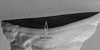
Close view of a triangular depression wall, seen by HiRISE. Layers are visible in the wall. These layers contain ice. The lower layers are tilted, while layers near the surface are mostly flat. This arrangement is called an "angular unconformity".
-
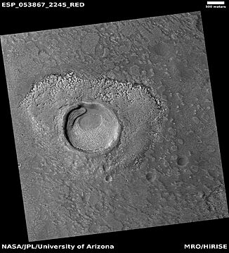
An impact crater that may have formed in ice-rich ground, seen by HiRISE under HiWish program. Location is the Ismenius Lacus quadrangle.
-
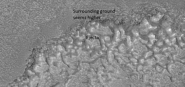
Close view of an impact crater that may have formed in ice-rich ground, seen by HiRISE under HiWish program. Notice that the ejecta (material thrown out by the impact) seems lower than the surroundings. The hot ejecta may have caused some of the ice to disappear, thus lowering the ejecta's level.
-
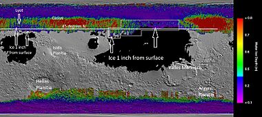
Map of near-surface ice.


Scalloped Landforms
Certain areas of Mars have scalloped-shaped depressions. These depressions are thought to be what's left of a melting, ice-rich layer. Scallops are caused by ice sublimating (turning directly into gas) from frozen soil. These scalloped landforms can be created by the loss of underground water ice through sublimation under Mars' current climate. A model predicts similar shapes when the ground has large amounts of pure ice, many tens of meters deep. This material was probably deposited from the atmosphere as ice formed on dust when the climate was different due to changes in Mars' tilt (see § Ice ages, below). The scallops are typically tens of meters deep and from a few hundred to a few thousand meters across. They can be almost circular or elongated. Some seem to have joined together, forming a large, heavily pitted area. The process might start with sublimation from a crack. There are often polygonal cracks where scallops form, and the presence of scalloped topography seems to indicate frozen ground.
On November 22, 2016, NASA reported finding a large amount of underground ice in Mars' Utopia Planitia region. The amount of water detected was estimated to be equal to the volume of water in Lake Superior.
The volume of water ice in the region was based on measurements from the ground-penetrating radar instrument on Mars Reconnaissance Orbiter, called SHARAD. From SHARAD data, the "dielectric permittivity" (or dielectric constant) was found. This value was consistent with a large amount of water ice.
These scalloped features look a bit like Swiss cheese features, found around the south polar cap. Swiss cheese features are thought to be caused by holes forming in a surface layer of solid carbon dioxide (dry ice), rather than water ice. However, the bottoms of these holes probably have a lot of water ice.
Ice Patches

On July 28, 2005, the European Space Agency announced a crater partly filled with frozen water. Some people then called it an "ice lake." Images of the crater, taken by the High Resolution Stereo Camera on the European Space Agency's Mars Express orbiter, clearly show a wide sheet of ice at the bottom of an unnamed crater in Vastitas Borealis. This is a large plain covering much of Mars' far northern latitudes, at about 70.5° North and 103° East. The crater is 35 kilometers wide and about 2 kilometers deep. The height difference between the crater floor and the ice surface is about 200 meters. ESA scientists think most of this height difference is due to sand dunes under the ice, which are partly visible. While scientists don't call it a "lake," this water ice patch is remarkable for its size and for being present all year. Deposits of water ice and layers of frost have been found in many different places on the planet.
As more and more of Mars' surface has been imaged by modern orbiters, it's become clearer that there are probably many more ice patches scattered across the surface. Many of these suspected ice patches are found in Mars' mid-latitudes (around 30–60° North/South of the equator). For example, many scientists think that the widespread features in those latitude bands, sometimes called "latitude dependent mantle" or "pasted-on terrain," are actually ice patches covered by dust or debris, slowly melting away. A debris cover is needed to explain why they look dull and don't reflect like ice, and also to allow them to exist for a long time without completely sublimating. These patches have been suggested as possible water sources for some of the mysterious channel features like gullies also seen in those latitudes.
Surface features that look like existing pack ice have been found in the southern Elysium Planitia. What appear to be plates, ranging from 30 meters to 30 kilometers in size, are found in channels leading to a large flooded area. The plates show signs of breaking up and rotating, which clearly sets them apart from lava plates elsewhere on Mars. The flood is thought to have come from the nearby geological fault Cerberus Fossae, which spewed water as well as lava about 2 to 10 million years ago. It was suggested that the water exited the Cerberus Fossae, then pooled and froze in the low, flat plains, and that such frozen lakes might still exist.
Glaciers

Many large areas of Mars either seem to have glaciers or show signs that they used to be there. Much of the high-latitude areas, especially the Ismenius Lacus quadrangle, are thought to still contain huge amounts of water ice. Recent evidence has led many planetary scientists to believe that water ice still exists as glaciers across much of Mars' mid- and high latitudes. These are protected from sublimation by thin layers of insulating rock and/or dust. An example is the glacier-like features called lobate debris aprons in an area called Deuteronilus Mensae. These show widespread evidence of ice under a few meters of rock debris. Glaciers are linked to fretted terrain and many volcanoes. Researchers have described glacial deposits on Hecates Tholus, Arsia Mons, Pavonis Mons, and Olympus Mons. Glaciers have also been reported in many larger Martian craters in the mid-latitudes and above.

Glacier-like features on Mars are known by different names like viscous flow features, Martian flow features, lobate debris aprons, or lineated valley fill. This depends on their shape, location, associated landforms, and the scientist describing them. Many, but not all, small glaciers seem to be linked to gullies on crater walls and mantling material. The lineated deposits known as lineated valley fill are probably rock-covered glaciers found on the floors of most channels within the fretted terrain around Arabia Terra in the northern hemisphere. Their surfaces have ridges and grooves that bend around obstacles. Lineated floor deposits might be related to lobate debris aprons, which orbiting radar has shown to contain large amounts of ice. For many years, researchers thought that features called 'lobate debris aprons' were glacial flows and that ice existed under a layer of insulating rocks. With new instrument readings, it has been confirmed that lobate debris aprons contain almost pure ice covered with a layer of rocks.

Moving ice carries rock material, then drops it when the ice disappears. This usually happens at the front or edges of the glacier. On Earth, these features are called moraines. But on Mars, they are typically known as moraine-like ridges, concentric ridges, or arcuate ridges. Since ice on Mars tends to sublimate (turn directly into gas) rather than melt, and because Mars' low temperatures make glaciers "cold based" (frozen to the ground and unable to slide), the remains of these glaciers and the ridges they leave don't look exactly like normal glaciers on Earth. Specifically, Martian moraines tend to be deposited without being changed by the land underneath. This is thought to mean the ice in Martian glaciers is usually frozen down and can't slide. Ridges of debris on the glacier surface show the direction the ice moved. The surface of some glaciers has rough textures because buried ice sublimates. The ice evaporates without melting, leaving an empty space. The material above then collapses into the void. Sometimes, chunks of ice fall from the glacier and get buried in the ground. When they melt, a more or less round hole remains. Many of these "kettle holes" have been found on Mars.
Despite strong evidence for glacial flow on Mars, there's little clear evidence for landforms carved by glacial erosion, like U-shaped valleys, crag and tail hills, or drumlins. Such features are common in glaciated areas on Earth, so their absence on Mars has been puzzling. The lack of these landforms is thought to be related to the "cold-based" nature of the ice in most recent Martian glaciers. Because the sunlight reaching the planet, the atmosphere's temperature and density, and the heat from inside Mars are all lower than on Earth, models suggest the temperature at the bottom of a glacier stays below freezing. The ice is literally frozen to the ground. This stops it from sliding, which is thought to prevent the ice from eroding the surface.
How Mars' Water Changed Over Time
The amount of water on Mars' surface is closely linked to how its atmosphere changed. This process might have had several key stages. Scientists have put together a detailed history of water on Mars.

Early Noachian Era (4.6 to 4.1 Billion Years Ago)
The early Noachian era saw the atmosphere being lost to space due to heavy meteorite impacts and gases escaping. Meteorites might have removed about 60% of the early atmosphere. A lot of phyllosilicates (clay minerals) might have formed during this time, which would need a thick enough atmosphere to keep water on the surface. However, the amount of carbon dioxide in the atmosphere would have been limited. Also, the young Sun was about 25% dimmer, so an ancient atmosphere with a strong greenhouse effect would have been needed to keep surface temperatures warm enough for liquid water. More CO2 alone wouldn't have been enough, as CO2 turns solid at certain pressures, making it less effective as a greenhouse gas.
Middle to Late Noachian Era (4.1 to 3.8 Billion Years Ago)
During this time, Mars might have formed a secondary atmosphere from gases released by the Tharsis volcanoes, including a lot of water, CO2, and SO2. Martian valley networks date back to this period, showing widespread and long-lasting surface water, not just sudden floods. This period ended when Mars' internal magnetic field stopped working, and there was a surge in meteorite impacts. The loss of the magnetic field allowed the solar wind to strip away the atmosphere more easily. For example, the ratios of certain gases in Mars' atmosphere suggest about 60% of argon, nitrogen, and CO2 were lost by solar wind stripping. Cometary impacts might also have added gases to the planet.
Hesperian to Amazonian Era (3.8 Billion Years Ago to Today)
During this time, occasional gas releases from volcanoes added to the atmosphere, but the solar wind continued to strip it away, though less intensely than before. Huge floods happened during this period, suggesting sudden underground releases of water, rather than continuous surface flows. While the earlier part of this era might have had acidic water environments and groundwater flowing from the Tharsis region, much of the surface changes later on were due to oxidation processes. This includes the formation of iron oxides that give Mars its reddish color. These iron oxides could have formed without free oxygen, through processes involving low-pH water, or hydrogen peroxide (H2O2) formed in the atmosphere. Since there was much less water and volcanic activity recently, H2O2 might have been the main cause of oxidation. However, underground water might have caused continuous, but very local, surface water in recent geological history, as seen in craters like Mojave. Also, the Lafayette Martian meteorite shows signs of water changing its rocks as recently as 650 million years ago.

In 2020, scientists reported that Mars' current loss of hydrogen from water is mostly caused by seasonal changes and dust storms. These events carry water directly to the upper atmosphere and have likely affected the planet's climate over the last billion years. More recent studies suggest that atmospheric gravity waves can play an important role during global dust storms in controlling how much water escapes.
Mars' Ice Ages

Mars has gone through about 40 big changes in the amount and location of ice on its surface over the past five million years. The most recent one happened about 2.1 to 0.4 million years ago, during the Late Amazonian glaciation at the dichotomy boundary. These changes are called ice ages. Ice ages on Mars are very different from Earth's. Mars' ice ages are caused by changes in its orbit and tilt (also called obliquity). Calculations show that Mars wobbles on its axis much more than Earth does. Earth is stabilized by its large moon, so it only wobbles a few degrees. Mars can change its tilt by many tens of degrees. When this tilt is high, its poles get much more direct sunlight and heat. This causes the ice caps to warm up and shrink as ice sublimates. Adding to the climate changes, Mars' orbit shape (eccentricity) changes twice as much as Earth's. As the poles sublimate, the ice is redeposited closer to the equator, which gets less sunlight at these high tilts. Computer simulations show that a 45° tilt of Mars' axis would lead to ice building up in areas that show signs of glaciers.
The moisture from the ice caps travels to lower latitudes as frost or snow mixed with dust. Mars' atmosphere has a lot of fine dust particles. Water vapor condenses on these particles, which then fall to the ground because of the extra weight of the water coating. When ice at the top of this covering layer returns to the atmosphere, it leaves behind dust. This dust then insulates the remaining ice. The total amount of water removed is a few percent of the ice caps, or enough to cover the entire planet with one meter of water. Much of this moisture from the ice caps creates a thick, smooth layer of ice and dust. This ice-rich layer, which can be 100 meters thick at mid-latitudes, smooths the land at lower latitudes. But in some places, it shows bumpy textures or patterns that reveal the presence of former water ice underneath.
Looking for Life on Mars

Since the Viking landers searched for tiny life forms in 1976, NASA has followed a "follow the water" strategy on Mars. However, liquid water is necessary but not enough for life as we know it. Whether a place can support life depends on many environmental factors. Chemical, physical, geological, and geographical features shape Mars' environments. Single measurements of these factors might not be enough to say an environment is habitable, but all the measurements together can help predict places with a higher or lower chance of supporting life.
Habitable environments don't have to be inhabited. For planetary protection reasons, scientists are trying to find potential habitats where bacteria from Earth on spacecraft could contaminate Mars. If life exists—or existed—on Mars, signs of it could be found underground, away from today's harsh surface conditions like perchlorates, radiation, dryness, and freezing. Habitable places could be kilometers below the surface in a theoretical water layer, or near the surface in contact with permafrost.
The Curiosity rover is studying Mars' past and present ability to support life. The European-Russian ExoMars program is a project focused on finding signs of life on Mars. It includes the ExoMars Trace Gas Orbiter, which started mapping atmospheric methane in April 2018, and the 2022 ExoMars rover, which will drill and analyze samples 2 meters deep. NASA's Mars 2020 rover will collect dozens of drilled core samples to potentially bring them back to Earth labs in the late 2020s or 2030s.
Discoveries by Space Probes
Mariner 9

The pictures taken by the Mariner 9 Mars orbiter, launched in 1971, showed the first direct evidence of past water. This included dry river beds, canyons (like the Valles Marineris, a canyon system over 4020 km long), signs of water erosion and deposition, weather fronts, fogs, and more. The findings from Mariner 9 laid the groundwork for the later Viking program. The enormous Valles Marineris canyon system is named after Mariner 9 to honor its achievements.
Viking Program

By finding many geological forms typically created by large amounts of water, the two Viking orbiters and two landers completely changed our knowledge about water on Mars. Huge outflow channels were found in many areas. They showed that floods broke through dams, carved deep valleys, eroded grooves into bedrock, and traveled thousands of kilometers. Large areas in the southern hemisphere had branched valley networks, suggesting that rain once fell. Many craters look as if the impactor landed in mud. When they formed, ice in the soil might have melted, turning the ground into mud, which then flowed across the surface. Regions called "Chaotic Terrain" seemed to have quickly lost huge amounts of water, causing large channels to form downstream. Estimates for some channel flows are ten thousand times the flow of the Mississippi River. Underground volcanism might have melted frozen ice; the water then flowed away, and the ground collapsed to leave chaotic terrain. Also, general chemical analysis by the two Viking landers suggested the surface had been exposed to or submerged in water in the past.
Mars Global Surveyor

The Mars Global Surveyor's Thermal Emission Spectrometer (TES) is a tool that can figure out the mineral makeup of Mars' surface. Mineral composition tells us about the presence or absence of water in ancient times. TES found a large (30,000 km²) area in the Nili Fossae formation that contains the mineral olivine. It's thought that the ancient asteroid impact that created the Isidis basin caused cracks that exposed the olivine. Finding olivine is strong evidence that parts of Mars have been extremely dry for a long time. Olivine was also found in many other small rock outcrops within 60 degrees north and south of the equator. The probe has imaged several channels that suggest past continuous liquid flows, two of them found in Nanedi Valles and Nirgal Vallis.

Mars Pathfinder
The Pathfinder lander recorded daily temperature changes. It was coldest just before sunrise, about -78°C, and warmest just after Mars noon, about -8°C. At this location, the highest temperature never reached the freezing point of water (0°C), which is too cold for pure liquid water to exist on the surface.
The atmospheric pressure measured by Pathfinder on Mars is very low—about 0.6% of Earth's. This low pressure would not allow pure liquid water to exist on the surface.
Other observations were consistent with water being present in the past. Some rocks at the Mars Pathfinder site leaned against each other in a way geologists call "imbricated." It's thought that strong flood waters in the past pushed the rocks around until they faced away from the flow. Some pebbles were rounded, perhaps from being tumbled in a stream. Parts of the ground are crusty, possibly due to minerals cementing them from a fluid. There was evidence of clouds and maybe fog.
Mars Odyssey

The 2001 Mars Odyssey found a lot of evidence for water on Mars through images. With its neutron spectrometer, it proved that much of the ground is full of water ice. Mars has enough ice just beneath the surface to fill Lake Michigan twice. In both hemispheres, from 55° latitude to the poles, Mars has a high density of ice just under the surface; one kilogram of soil contains about 500 grams of water ice. But close to the equator, there is only 2% to 10% water in the soil. Scientists think much of this water is also locked in the chemical structure of minerals, like clay and sulfates. Although the top surface has a few percent of chemically-bound water, ice lies just a few meters deeper, as shown in Arabia Terra, Amazonis quadrangle, and Elysium quadrangle, which contain large amounts of water ice. The orbiter also found vast deposits of bulk water ice near the surface of equatorial regions. Evidence for water near the equator is both in the landforms and the mineral composition, seen at both the Medusae Fossae formation and the Tharsis Montes. Analysis of the data suggests that the southern hemisphere might have layers, hinting at stratified deposits beneath a now-gone large body of water.

The instruments on the Mars Odyssey can study the top meter of soil. In 2002, available data were used to calculate that if all soil surfaces were covered by an even layer of water, this would correspond to a global layer of water (GLW) 0.5-1.5 kilometers deep.
Thousands of images from the Odyssey orbiter also support the idea that Mars once had huge amounts of water flowing across its surface. Some images show patterns of branching valleys; others show layers that might have formed under lakes; even river and lake deltas have been identified. For many years, researchers suspected that glaciers exist under a layer of insulating rocks. Lineated valley fill is one example of these rock-covered glaciers. They are found on the floors of some channels. Their surfaces have ridges and grooves that bend around obstacles. Lineated floor deposits might be related to lobate debris aprons, which orbiting radar has shown to contain large amounts of ice.
Phoenix

The Phoenix lander also confirmed a lot of water ice in Mars' northern region. This finding was predicted by earlier orbital data and theory, and was measured from orbit by the Mars Odyssey instruments. On June 19, 2008, NASA announced that bright, dice-sized clumps in the "Dodo-Goldilocks" trench, dug by the robotic arm, had turned into gas over four days. This strongly indicated that the bright clumps were water ice that sublimated after being exposed. Recent models show this water ice was snow with tiny grains and a small amount of dust. Even though CO2 (dry ice) also sublimates under these conditions, it would do so much faster than observed. On July 31, 2008, NASA announced that Phoenix further confirmed water ice at its landing site. During the first heating of a sample, the mass spectrometer detected water vapor when the sample reached 0°C. Stable liquid water cannot exist on Mars' surface with its current low atmospheric pressure and temperature (it would boil), except at the lowest elevations for short times.
The presence of the perchlorate (ClO4–) anion, a strong oxidizer, was confirmed in the Martian soil. This salt can significantly lower the water freezing point.

When Phoenix landed, its retrorockets splashed soil and melted ice onto the vehicle. Photographs showed blobs of material stuck to the landing struts. The blobs expanded at a rate consistent with deliquescence (absorbing moisture from the air), darkened before disappearing (consistent with turning liquid and dripping), and seemed to merge. These observations, along with scientific evidence, suggested the blobs were likely liquid brine droplets. Other researchers suggested the blobs could be "clumps of frost." In 2015, it was confirmed that perchlorate plays a role in forming recurring slope lineae on steep gullies.
As far as the camera could see, the landing site is flat but shaped into polygons 2-3 meters wide, bounded by troughs 20-50 cm deep. These shapes are due to ice in the soil expanding and contracting with big temperature changes. The microscope showed that the soil on top of the polygons is made of rounded and flat particles, probably a type of clay. Ice is present a few inches below the surface in the middle of the polygons, and along their edges, the ice is at least 8 inches deep.
Snow was seen falling from cirrus clouds. The clouds formed at a level in the atmosphere that was around -65°C, so the clouds must have been made of water-ice, not carbon dioxide-ice (dry ice), because the temperature for forming carbon dioxide ice is much lower than -120°C. As a result of mission observations, it is now thought that water ice (snow) would have built up later in the year at this location. The highest temperature measured during the mission, which happened during the Martian summer, was -19.6°C, while the coldest was -97.7°C. So, in this region, the temperature stayed far below the freezing point (0°C) of water.
Mars Exploration Rovers


The Mars Exploration Rovers, Spirit and Opportunity, found a lot of evidence for past water on Mars. The Spirit rover landed in what was thought to be a large lake bed. The lake bed had been covered by lava flows, so evidence of past water was hard to find at first. On March 5, 2004, NASA announced that Spirit had found hints of water history on Mars in a rock called "Humphrey."
As Spirit drove backward in December 2007, dragging a stuck wheel, the wheel scraped off the top layer of soil. This uncovered a patch of white ground rich in silica. Scientists think it must have been formed in one of two ways. One: hot spring deposits created when water dissolved silica in one place and carried it to another (like a geyser). Two: acidic steam rising through cracks in rocks stripped them of their minerals, leaving silica behind. The Spirit rover also found evidence for water in the Columbia Hills of Gusev crater. In the Clovis group of rocks, the Mössbauer spectrometer (MB) detected goethite, which only forms in the presence of water, iron in the oxidized form Fe3+, and carbonate-rich rocks. This means parts of the planet once held water.
The Opportunity rover was sent to a site that had shown large amounts of hematite from orbit. Hematite often forms from water. The rover indeed found layered rocks and marble- or blueberry-like hematite concretions. Elsewhere on its journey, Opportunity studied wind-blown sand layers in Burns Cliff in Endurance Crater. Its operators concluded that these rock outcrops were preserved and hardened by the flow of shallow underground water. In its years of continuous operation, Opportunity sent back evidence that this area on Mars was soaked in liquid water in the past.
The MER rovers found evidence for ancient wet environments that were very acidic. In fact, Opportunity found signs of sulfuric acid, a harsh chemical for life. But on May 17, 2013, NASA announced that Opportunity found clay deposits that usually form in wet environments that are close to neutral acidity. This finding provides more evidence about a wet ancient environment possibly good for life.
Mars Reconnaissance Orbiter

The Mars Reconnaissance Orbiter's HiRISE instrument has taken many pictures that strongly suggest Mars has had a rich history of water-related processes. A major discovery was finding evidence of ancient hot springs. If they hosted tiny life forms, they might contain biosignatures (signs of life). Research published in January 2010 described strong evidence for continuous precipitation in the area around Valles Marineris. The types of minerals there are linked to water. Also, the high number of small branching channels indicates a lot of precipitation.
Rocks on Mars are often found in layers, called strata, in many different places. Layers form in various ways, including from volcanoes, wind, or water. Light-colored rocks on Mars have been linked to hydrated minerals like sulfates and clay.

The orbiter helped scientists determine that much of Mars' surface is covered by a thick, smooth layer thought to be a mixture of ice and dust.
The ice layer under the shallow surface is thought to be from frequent, major climate changes. Changes in Mars' orbit and tilt cause big changes in where water ice is found, from the poles down to latitudes similar to Texas. During certain climate periods, water vapor leaves the polar ice and enters the atmosphere. The water then returns to the ground at lower latitudes as frost or snow mixed generously with dust. Mars' atmosphere has a lot of fine dust particles. Water vapor condenses on these particles, then they fall to the ground due to the extra weight of the water coating. When ice at the top of the covering layer goes back into the atmosphere, it leaves behind dust, which insulates the remaining ice.
In 2008, research using the Shallow Radar on the Mars Reconnaissance Orbiter provided strong evidence that the lobate debris aprons (LDA) in Hellas Planitia and in mid-northern latitudes are glaciers covered with a thin layer of rocks. Its radar also detected a strong reflection from the top and bottom of LDAs, meaning that pure water ice made up most of the formation. The discovery of water ice in LDAs shows that water is found at even lower latitudes.
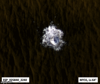
Research published in September 2009 showed that some new craters on Mars expose pure water ice. After a while, the ice disappears, evaporating into the atmosphere. The ice is only a few feet deep. The ice was confirmed with the Compact Imaging Spectrometer (CRISM) on board the Mars Reconnaissance Orbiter. Similar exposures of ice have been found within the mid-latitude mantle (originally thought to contain buried dusty snow covered with dust and soil) that drapes most pole-facing slopes in the mid-latitudes, using spectral analysis of HiRISE images.
Additional reports published in 2019 looked at the amount of water ice at the northern pole. One report used data from the MRO's SHARAD (SHAllow RADar sounder) probes. SHARAD can scan up to about 2 kilometers below the surface at 15-meter intervals. Analysis of past SHARAD runs showed evidence of layers of water ice and sand below the Planum Boreum, with as much as 60% to 88% of the volume being water ice. This supports the idea of Mars' long-term global weather having cycles of global warming and cooling. During cooling periods, water gathered at the poles to form ice layers. Then, as global warming happened, the unfrozen water ice was covered by dust and dirt from Mars' frequent dust storms. The total ice volume found in this study was about 2.2e5 cubic kilometers, or enough water, if melted, to cover Mars' surface with a 1.5-meter layer of water. This work was supported by a separate study that used recorded gravity data to estimate the density of the Planum Boreum, indicating that on average, it contained up to 55% by volume of water ice.
Many features that look like pingos on Earth were found in Utopia Planitia (~35-50° N; ~80-115° E) by looking at photos from HiRISE. Pingos have a core of ice.
Curiosity Rover


Very early in its mission, NASA's Curiosity rover found clear evidence of fluvial (river-related) sediments on Mars. The pebbles in these rock outcrops suggested strong water flow in a streambed, with water between ankle- and waist-deep. These rocks were found at the bottom of an alluvial fan system coming down from the crater wall, which had been identified from orbit earlier.
In October 2012, Curiosity performed the first X-ray diffraction analysis of Martian soil. The results showed several minerals, including feldspar, pyroxenes, and olivine. This suggested that the Martian soil in the sample was similar to weathered basaltic soils found near Hawaiian volcanoes. The sample used was made of dust from global dust storms and local fine sand. So far, the materials Curiosity has analyzed fit the initial idea that deposits in Gale Crater show a change over time from a wet to a dry environment.
In December 2012, NASA reported that Curiosity did its first extensive soil analysis, finding water molecules, sulfur, and chlorine in the Martian soil. And in March 2013, NASA reported evidence of mineral hydration, likely hydrated calcium sulfate, in several rock samples, including broken pieces of "Tintina" rock and "Sutton Inlier" rock, as well as in veins and nodules in other rocks like "Knorr" rock and "Wernicke" rock. Analysis using the rover's DAN instrument showed evidence of underground water, up to 4% water content, down to a depth of 60 cm, along the rover's path from the Bradbury Landing site to the Yellowknife Bay area in the Glenelg terrain.
On September 26, 2013, NASA scientists reported that the Mars Curiosity rover detected a lot of chemically-bound water (1.5 to 3 weight percent) in soil samples at the Rocknest region of Aeolis Palus in Gale Crater. In addition, NASA reported the rover found two main soil types: a fine-grained mafic type and a locally derived, coarse-grained felsic type. The mafic type, similar to other martian soils and martian dust, was linked to water hydrating the amorphous parts of the soil. Also, perchlorates, which can make it hard to find life-related organic molecules, were found at the Curiosity rover landing site (and earlier at the more polar site of the Phoenix lander), suggesting these salts are found "globally." NASA also reported that Jake M rock, a rock Curiosity found on the way to Glenelg, was a mugearite and very similar to mugearite rocks on Earth.
On December 9, 2013, NASA reported that Mars once had a large freshwater lake inside Gale Crater. This lake could have been a good place for microbial life.
On December 16, 2014, NASA reported finding an unusual increase, then decrease, in the amounts of methane in the atmosphere of Mars. Also, organic chemicals were found in powder drilled from a rock by the Curiosity rover. Based on studies of the deuterium to hydrogen ratio, much of the water at Gale Crater on Mars was found to have been lost in ancient times, before the lake bed in the crater formed. After that, large amounts of water continued to be lost.
On April 13, 2015, Nature published an analysis of humidity and ground temperature data collected by Curiosity. It showed evidence that thin films of liquid brine water form in the top 5 cm of Mars' subsurface at night. The water activity and temperature remain too low for known Earth microorganisms to reproduce and grow.
On October 8, 2015, NASA confirmed that lakes and streams existed in Gale crater 3.3 – 3.8 billion years ago. They delivered sediments to build up the lower layers of Mount Sharp.
On November 4, 2018, geologists presented evidence, based on studies in Gale Crater by the Curiosity rover, that there was plenty of water on early Mars.
Mars Express
The Mars Express Orbiter, launched by the European Space Agency, has been mapping Mars' surface and using radar to look for underground water. Between 2012 and 2015, the Orbiter scanned the area beneath the ice caps on the Planum Australe. By 2018, scientists determined that the readings indicated an underground lake about 20 kilometers wide. The top of the lake is 1.5 kilometers under the planet's surface; how much deeper the liquid water goes is still unknown.
Zhurong Rover
China's Zhurong rover landed on Mars in the Utopia Planitia region on May 14, 2021. It has six scientific instruments, including two cameras, a ground-penetrating radar, and a magnetic field detector. Zhurong used a laser to zap rocks and study what they are made of.
Zhurong found evidence of water when it examined the surface crust, called "duricrust." This crust contained hydrated sulfate/silica materials in the Amazonian-age terrain of the landing site. The duricrust was formed either by underground ice melting or groundwater rising.
Looking at the dunes at Zhurong's landing site, researchers found a big shift in wind direction (seen in the dune directions) that happened around the same time that layers in the Martian northern ice caps changed. It was suggested that these events occurred when the planet's rotational tilt changed.
|
See also
 In Spanish: Presencia de agua en Marte para niños
- Atmospheric water on Mars
- Climate of Mars
- Colonization of Mars
- Evolution of water on Mars and Earth
- Extraterrestrial liquid water
- Lakes on Mars
- Life on Mars
- Mars Express § Scientific discoveries and important events
- Mars Global Surveyor § Discovery of water ice on Mars
- Martian canals
- Mud cracks on Mars
