
Houston facts for kids
Quick facts for kids
Houston
|
|||
|---|---|---|---|
|
City
|
|||
|
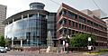
Texas Medical Center
|
|||
|
|||
| Nickname(s):
Space City (official), more ...
|
|||

Houston
Location in Texas

Houston
Location in the United States
|
|||
| Country | United States | ||
| State | Texas | ||
| Counties | Harris, Fort Bend, Montgomery | ||
| Incorporated | June 5, 1837 | ||
| Named for | Sam Houston | ||
| Government | |||
| • Type | Strong Mayor-Council | ||
| • Body | Houston City Council | ||
| Area | |||
| • City | 671.67 sq mi (1,740 km2) | ||
| • Land | 640.44 sq mi (1,658.73 km2) | ||
| • Water | 31.23 sq mi (80.89 km2) | ||
| Elevation | 80 ft (32 m) | ||
| Population
(2020)
|
|||
| • City | 2,301,572 | ||
| • Estimate
(2023)
|
2,314,157 | ||
| • Rank | 6th in North America 4th in the United States 1st in Texas |
||
| • Density | 3,613.38/sq mi (1,395.13/km2) | ||
| • Urban | 5,853,575 (US: 5th) | ||
| • Urban density | 3,339.8/sq mi (1,289.5/km2) | ||
| • Metro | 7,122,240 (US: 5th) | ||
| Demonym(s) | Houstonian | ||
| GDP | |||
| • Metro | $633.185 billion (2022) | ||
| Time zone | UTC−6 (CST) | ||
| • Summer (DST) | UTC−5 (CDT) | ||
| ZIP Codes |
770xx, 772xx (P.O. Boxes)
|
||
| Area codes | 713, 281, 832, 346 | ||
| FIPS code | 48-35000 | ||
| GNIS feature ID | 1380948 | ||


.jpg)


Houston (![]() i/ˈhjuːstən/ HEW-stən) is the largest city in Texas. It is also the fourth-largest city in the United States. Houston is located in Southeast Texas, close to the Gulf of Mexico. It is the main city of the Greater Houston area. This area is home to over 7 million people.
i/ˈhjuːstən/ HEW-stən) is the largest city in Texas. It is also the fourth-largest city in the United States. Houston is located in Southeast Texas, close to the Gulf of Mexico. It is the main city of the Greater Houston area. This area is home to over 7 million people.
Houston was started by land investors on August 30, 1836. It became a city on June 5, 1837. The city is named after Sam Houston. He was a general who helped Texas win its freedom from Mexico. Houston was briefly the capital of Texas. It grew into a major trading center.
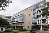
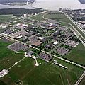
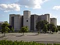
In the 20th century, Houston grew very fast. This was thanks to its busy port and railroads. After a big hurricane hit Galveston in 1900, Houston's port became even more important. The discovery of oil in Texas also helped Houston's economy. Later, the city became home to the Texas Medical Center. This is the world's largest group of healthcare and research places. NASA's Johnson Space Center is also in Houston. This is where the Mission Control Center is located.
Houston's economy is strong in many areas. These include energy, making things, space, and transportation. It has many large company headquarters. The Port of Houston is very busy. It handles a lot of international trade.
Houston is known as "Space City" because of NASA. It is also called "Bayou City" because of its many waterways. Houston is a global city. This means it is important for culture, medicine, and research around the world. The city has many different cultures and people from all over the world. It is one of the most diverse cities in the U.S. Houston has many museums and theaters.
Contents
Houston's Story: A Look at its Past
Long ago, the land where Houston now stands was home to Native American tribes. These included the Karankawa and Atakapa people. They lived there for at least 2,000 years. Later, the land was mostly empty until settlers arrived in the 1830s.
How Houston Began
Two brothers, Augustus Chapman Allen and John Kirby Allen, bought land in 1836. They wanted to create a new town. They named it Houston after Sam Houston. He was a hero of the Texas Revolution.
The brothers worked hard to make Houston the temporary capital of the Republic of Texas. They even promised to build a state capitol building. By 1837, about 1,500 people lived in Houston. It officially became a city on June 5, 1837.
In 1839, the capital moved to Austin. Houston still grew as a trading center. Farmers brought their goods to Houston. From there, they could ship them to Galveston and the Gulf of Mexico. This helped Houston's businesses.

By 1860, Houston was a big center for cotton trade. Railroads connected Houston to other parts of Texas and to ports. After the American Civil War, business people made the city's waterways wider. This allowed more ships to come into Downtown Houston. By 1890, Houston was the main railroad city in Texas.
Growing into a Major City
In 1900, a terrible hurricane hit Galveston. This made people work even faster to make Houston a deep-water port. The next year, oil was found nearby. This started the Texas oil industry. In 1914, President Woodrow Wilson opened the deep-water Port of Houston. By 1930, Houston was the biggest city in Texas.
During World War II, Houston's port slowed down. But the war brought new jobs. Factories were built to make oil products and rubber. Many people moved to Houston for these jobs.
In 1945, the Texas Medical Center was created. After the war, Houston's economy grew even more. In 1948, the city added many new areas, doubling its size. In the 1950s, air conditioning became common. This made Houston a more comfortable place to live and work. Many companies moved there.
NASA's "Manned Spacecraft Center" opened in 1961. It was later renamed the Lyndon B. Johnson Space Center. This helped Houston's space industry grow. In 1965, the Astrodome opened. It was the world's first indoor domed sports stadium. People called it the "Eighth Wonder of the World."
In the late 1970s, many people moved to Houston. They came from other states for jobs in the oil industry. This was after the 1973 oil crisis. Houston became a place for many college graduates.
Houston in the 21st Century
Houston has continued to grow in the 2000s. Its population increased by over 15% from 2000 to 2022.
Oil, Gas, and New Technologies
Oil and gas are still very important to Houston's economy. Many major oil companies have their main offices here. Houston is also becoming a center for new technology companies. In 2022, Hewlett Packard Enterprise moved its main office to the Houston area.
Healthcare Advances
Healthcare has become a huge industry in Houston. The Texas Medical Center is the largest medical complex in the world. It employs over 120,000 people.
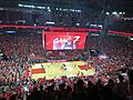
Sports Excitement
Three new sports stadiums opened in Downtown Houston in the early 2000s. The Houston Astros baseball team opened Daikin Park in 2000. The Houston Texans football team started in 2002. NRG Stadium opened for them. In 2003, the Toyota Center opened for the Houston Rockets basketball team. The Houston Dynamo soccer team started in 2005. The Astros won their first World Series in 2017.
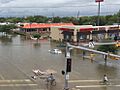
Dealing with Flooding
.jpg)
Flooding has been a problem in Houston. In 2001, Tropical Storm Allison caused severe flooding. In 2017, Hurricane Harvey brought record rainfall. Some areas got over 50 inches of rain. This caused huge damage and was one of the worst natural disasters in U.S. history. The city has made new rules for building homes to help prevent future flood damage.
In May 2024, a strong storm called a derecho caused a lot of damage across the city.
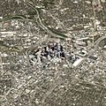
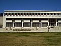
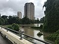
Houston's Landscape and Buildings
.jpg)
Houston is about 165 miles east of Austin. It is 88 miles west of the Louisiana border. The city covers a total area of about 637 square miles. Most of Houston is on a flat coastal plain.
Much of the city was built on land that was once forests, marshes, or swamps. You can still see these areas nearby. The flat land and new building have made flooding worse. Downtown Houston is about 50 feet above sea level. The highest point in northwest Houston is about 150 feet high.
Houston used to get its water from underground. But the land started sinking. So now, the city gets water from lakes like Lake Houston.
Houston has four main waterways called bayous. They help drain water from the city. Buffalo Bayou runs through Downtown and connects to the Houston Ship Channel. This channel goes all the way to the Gulf of Mexico.
How the Land Was Formed

Houston is a flat, marshy area. It has a large drainage system. The land is made of soft clays and sands. These layers formed from river deposits. Over time, these sediments created oil and natural gas.
The Houston area has many active faults. These are cracks in the Earth's crust. They move slowly, which is called "fault creep." This means they usually don't cause earthquakes. However, some land in southeast Houston is sinking. This is because a lot of water has been pumped out of the ground.
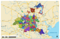
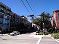
City Layout and Neighborhoods

Houston was divided into "wards" when it became a city in 1837. Today, it has 11 city council districts.
People often describe Houston as being "inside the loop" or "outside the loop." The "Inner Loop" is inside I-610. This area includes Downtown and older neighborhoods. Outside the loop, the city looks more like a suburb. But it still has many big business areas. These include Uptown and the Houston Energy Corridor.

Houston is the largest city in the U.S. without formal zoning laws. Zoning laws usually separate different types of land use, like homes from businesses. However, Houston has other rules that help guide how the city grows. For example, there are rules about how big lots for houses must be.
These rules have had different effects. Some say they lead to the city spreading out a lot. Others say they help keep housing affordable. Houston has many business districts, not just one downtown area. These include Uptown, the Texas Medical Center, and Midtown.
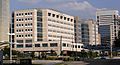
.jpg)

Tall Buildings and Design
Houston has one of the tallest skylines in North America. In 2015, it was the fifth tallest. Downtown Houston has a system of tunnels and skywalks. These connect buildings with shops and restaurants. This helps people avoid the summer heat and rain.
Many tall skyscrapers were built in the 1970s and 1980s. The JPMorgan Chase Tower is the tallest building in Texas. It is 75 floors high. The Williams Tower in Uptown is also very tall. It was once thought to be the tallest skyscraper outside a main business district. Since 2000, over 30 new skyscrapers have been built in Houston.
-
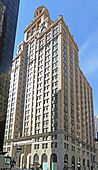
The Niels Esperson Building was Houston's tallest from 1927 to 1929.
-
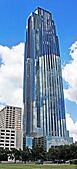
The JPMorgan Chase Tower is the tallest building in Texas.
-
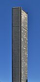
The Williams Tower is very tall for a building outside a city center.
-
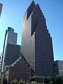
The Bank of America Center shows a style called postmodern architecture.


Houston's Weather
.jpg)
Houston has a humid subtropical climate. This means it has hot, humid summers and mild winters. Winds from the Gulf of Mexico bring heat and moisture.
In summer, temperatures often reach over 90°F (32°C). It can even get over 100°F (38°C) a few days a year. The humidity makes it feel even hotter. Air conditioning is very common in Houston homes. The hottest temperature ever recorded was 109°F (43°C).

Winters in Houston are mild. It rarely snows. When it does, it's usually just a small amount. The coldest temperature ever recorded was 5°F (-15°C) in 1930.
Houston gets a lot of rain, about 50 inches (127 cm) each year. Because the land is flat, heavy rains can cause flooding. Major floods happened in 2001 (Tropical Storm Allison) and 2017 (Hurricane Harvey). The city has made new rules to help buildings be safer from floods.
Houston also has high ozone levels, which is a type of air pollution. This is mainly from industries along the ship channel.
| Climate data for Houston (Intercontinental Airport), 1981–2010 normals, extremes 1888–present | |||||||||||||
|---|---|---|---|---|---|---|---|---|---|---|---|---|---|
| Month | Jan | Feb | Mar | Apr | May | Jun | Jul | Aug | Sep | Oct | Nov | Dec | Year |
| Record high °F (°C) | 84 (29) |
91 (33) |
96 (36) |
95 (35) |
99 (37) |
107 (42) |
105 (41) |
109 (43) |
109 (43) |
99 (37) |
89 (32) |
85 (29) |
109 (43) |
| Mean maximum °F (°C) | 78.4 (25.8) |
80.8 (27.1) |
84.8 (29.3) |
88.9 (31.6) |
93.6 (34.2) |
97.0 (36.1) |
98.4 (36.9) |
100.4 (38.0) |
96.9 (36.1) |
91.8 (33.2) |
85.0 (29.4) |
80.0 (26.7) |
101.0 (38.3) |
| Mean daily maximum °F (°C) | 62.9 (17.2) |
66.3 (19.1) |
73.0 (22.8) |
79.6 (26.4) |
86.3 (30.2) |
91.4 (33.0) |
93.7 (34.3) |
94.5 (34.7) |
89.7 (32.1) |
82.0 (27.8) |
72.5 (22.5) |
64.3 (17.9) |
79.7 (26.5) |
| Daily mean °F (°C) | 53.1 (11.7) |
56.4 (13.6) |
62.7 (17.1) |
69.5 (20.8) |
76.9 (24.9) |
82.4 (28.0) |
84.4 (29.1) |
84.6 (29.2) |
79.8 (26.6) |
71.5 (21.9) |
62.3 (16.8) |
54.4 (12.4) |
69.9 (21.1) |
| Mean daily minimum °F (°C) | 43.2 (6.2) |
46.5 (8.1) |
52.5 (11.4) |
59.4 (15.2) |
67.6 (19.8) |
73.5 (23.1) |
75.1 (23.9) |
74.8 (23.8) |
69.8 (21.0) |
60.9 (16.1) |
52.1 (11.2) |
44.6 (7.0) |
60.0 (15.6) |
| Mean minimum °F (°C) | 26.7 (−2.9) |
29.5 (−1.4) |
34.0 (1.1) |
42.0 (5.6) |
53.3 (11.8) |
65.2 (18.4) |
69.4 (20.8) |
68.6 (20.3) |
55.7 (13.2) |
43.4 (6.3) |
34.5 (1.4) |
27.5 (−2.5) |
23.5 (−4.7) |
| Record low °F (°C) | 5 (−15) |
6 (−14) |
21 (−6) |
31 (−1) |
42 (6) |
52 (11) |
62 (17) |
54 (12) |
45 (7) |
29 (−2) |
19 (−7) |
7 (−14) |
5 (−15) |
| Average precipitation inches (mm) | 3.38 (86) |
3.20 (81) |
3.41 (87) |
3.31 (84) |
5.09 (129) |
5.93 (151) |
3.79 (96) |
3.76 (96) |
4.12 (105) |
5.70 (145) |
4.34 (110) |
3.74 (95) |
49.77 (1,264) |
| Average precipitation days (≥ 0.01 in) | 9.6 | 9.2 | 8.8 | 6.8 | 8.0 | 10.6 | 9.1 | 8.3 | 8.0 | 7.9 | 8.2 | 9.5 | 104.0 |
| Average relative humidity (%) | 74.7 | 73.4 | 72.7 | 73.1 | 75.0 | 74.6 | 74.4 | 75.1 | 76.8 | 75.4 | 76.0 | 75.5 | 74.7 |
| Mean monthly sunshine hours | 143.4 | 155.0 | 192.5 | 209.8 | 249.2 | 281.3 | 293.9 | 270.5 | 236.5 | 228.8 | 168.3 | 148.7 | 2,577.9 |
| Percent possible sunshine | 44 | 50 | 52 | 54 | 59 | 67 | 68 | 66 | 64 | 64 | 53 | 47 | 58 |
| Source: NOAA (relative humidity 1969–1990, sun 1961–1990) | |||||||||||||
| Climate data for Houston (William P. Hobby Airport), 1991–2020 normals, extremes 1930–present | |||||||||||||
|---|---|---|---|---|---|---|---|---|---|---|---|---|---|
| Month | Jan | Feb | Mar | Apr | May | Jun | Jul | Aug | Sep | Oct | Nov | Dec | Year |
| Record high °F (°C) | 92 (33) |
93 (34) |
96 (36) |
94 (34) |
100 (38) |
105 (41) |
104 (40) |
109 (43) |
108 (42) |
98 (37) |
95 (35) |
94 (34) |
109 (43) |
| Mean maximum °F (°C) | 78.2 (25.7) |
80.6 (27.0) |
84.3 (29.1) |
87.8 (31.0) |
92.5 (33.6) |
96.4 (35.8) |
98.1 (36.7) |
99.3 (37.4) |
96.1 (35.6) |
91.4 (33.0) |
84.7 (29.3) |
80.5 (26.9) |
100.2 (37.9) |
| Mean daily maximum °F (°C) | 63.8 (17.7) |
67.6 (19.8) |
73.4 (23.0) |
79.3 (26.3) |
85.9 (29.9) |
91.0 (32.8) |
92.9 (33.8) |
93.5 (34.2) |
89.3 (31.8) |
82.1 (27.8) |
72.6 (22.6) |
65.7 (18.7) |
79.8 (26.6) |
| Daily mean °F (°C) | 55.0 (12.8) |
58.9 (14.9) |
64.7 (18.2) |
70.6 (21.4) |
77.6 (25.3) |
83.0 (28.3) |
84.8 (29.3) |
85.1 (29.5) |
81.1 (27.3) |
73.0 (22.8) |
63.3 (17.4) |
56.9 (13.8) |
71.2 (21.8) |
| Mean daily minimum °F (°C) | 46.1 (7.8) |
50.1 (10.1) |
55.9 (13.3) |
61.8 (16.6) |
69.3 (20.7) |
74.9 (23.8) |
76.6 (24.8) |
76.7 (24.8) |
72.9 (22.7) |
63.9 (17.7) |
54.0 (12.2) |
48.0 (8.9) |
62.5 (16.9) |
| Mean minimum °F (°C) | 30.5 (−0.8) |
34.5 (1.4) |
38.7 (3.7) |
46.5 (8.1) |
57.2 (14.0) |
68.7 (20.4) |
72.3 (22.4) |
72.0 (22.2) |
62.2 (16.8) |
47.2 (8.4) |
36.8 (2.7) |
32.8 (0.4) |
28.4 (−2.0) |
| Record low °F (°C) | 10 (−12) |
14 (−10) |
22 (−6) |
36 (2) |
44 (7) |
56 (13) |
64 (18) |
66 (19) |
50 (10) |
33 (1) |
25 (−4) |
9 (−13) |
9 (−13) |
| Average precipitation inches (mm) | 4.09 (104) |
2.85 (72) |
3.28 (83) |
4.08 (104) |
5.42 (138) |
6.09 (155) |
4.59 (117) |
5.44 (138) |
5.76 (146) |
5.78 (147) |
3.90 (99) |
4.34 (110) |
55.62 (1,413) |
| Average precipitation days (≥ 0.01 in) | 10.2 | 8.9 | 8.3 | 8.0 | 7.7 | 10.4 | 9.2 | 9.6 | 9.8 | 7.2 | 8.4 | 9.5 | 107.2 |
| Source 1: NOAA | |||||||||||||
| Source 2: National Weather Service | |||||||||||||
.jpg)
Who Lives in Houston?
| Historical population | |||
|---|---|---|---|
| Census | Pop. | %± | |
| 1850 | 2,396 | — | |
| 1860 | 4,845 | 102.2% | |
| 1870 | 9,382 | 93.6% | |
| 1880 | 16,513 | 76.0% | |
| 1890 | 27,557 | 66.9% | |
| 1900 | 44,633 | 62.0% | |
| 1910 | 78,800 | 76.6% | |
| 1920 | 138,276 | 75.5% | |
| 1930 | 292,352 | 111.4% | |
| 1940 | 384,514 | 31.5% | |
| 1950 | 596,163 | 55.0% | |
| 1960 | 938,219 | 57.4% | |
| 1970 | 1,232,802 | 31.4% | |
| 1980 | 1,595,138 | 29.4% | |
| 1990 | 1,630,553 | 2.2% | |
| 2000 | 1,953,631 | 19.8% | |
| 2010 | 2,099,451 | 7.5% | |
| 2020 | 2,301,572 | 9.6% | |
| 2023 (est.) | 2,314,157 | 10.2% | |
| U.S. Decennial Census 1850–1900 1910 1920 1930 1940 1950 1960 1970 1980 1990 2000 2010 |
|||

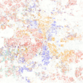
Houston is a very diverse city. This means many different ethnic and cultural groups live there. It is known as one of the most diverse cities in the U.S. This is partly because of its lower cost of living and good job market.
In 2020, Houston had over 2.3 million people. The city has grown a lot since 1850. Many people from other countries have moved to Houston. This includes people from Latin America and Asia.
Houston also has a large and important African American community. Many black professionals and business owners choose to live in Houston.
In 2019, about 45.8% of Houston's population was Hispanic or Latino. About 23.3% were non-Hispanic white. Around 22.4% were black or African American. And 6.5% were Asian American.
Religious Life in Houston
| Historical racial and ethnic composition | 2020 | 2010 | 2000 | 1990 | 1970 |
|---|---|---|---|---|---|
| Hispanic or Latino (of any race) | 47.0% | 43.8% | 37.4% | 27.6% | 11.3% |
| Whites (Non-Hispanic) | 21.8% | 25.6% | 30.8% | 40.6% | 62.4% |
| Black or African American | 24.9% | 25.1% | 25.3% | 28.1% | 25.7% |
| Asian | 7.1% | 6.0% | 5.3% | 4.1% | 0.4% |
| Religious affiliation (2020) | ||||
|---|---|---|---|---|
| Christian | 72% | |||
| Protestant | 40% | |||
| Catholic | 29% | |||
| Other Christian | 3% | |||
| Unaffiliated | 21% | |||
| Muslim | 2% | |||
| Jewish | 1% | |||
| Buddhist | 1% | |||
| Hindu | 0.5% | |||
| Other faiths | 1.5% | |||
Houston is a very religious city. Most people in Houston are Christians. About 72% of the population identifies as Christian. This includes Protestants and Catholics.
Other religions are also growing in Houston. This is due to people moving there from different parts of the world. These religions include Islam, Judaism, Buddhism, and Hinduism.
Lakewood Church in Houston is the largest church in the United States. It is led by Pastor Joel Osteen. The Roman Catholic Archdiocese of Galveston–Houston is also very large. It has about 1.7 million Catholics.

Houston has many different types of churches. These include Eastern and Oriental Orthodox churches. There are also over 40 synagogues for the Jewish community. Houston's Muslim community is the largest in Texas. It has many mosques. There are also Hindu temples and Sikh gurdwaras.

Houston's Economy: How the City Works
| Fortune 500 companies based in Houston | ||
| Rank | Company | |
|---|---|---|
| 27 | Phillips 66 | |
| 56 | Sysco | |
| 93 | ConocoPhillips | |
| 98 | Plains GP Holdings | |
| 101 | Enterprise Products Partners | |
| 129 | Baker Hughes | |
| 142 | Halliburton | |
| 148 | Occidental Petroleum | |
| 186 | EOG Resources | |
| 207 | Waste Management | |
| 242 | Kinder Morgan | |
| 260 | CenterPoint Energy | |
| 261 | Quanta Services | |
| 264 | Group 1 Automotive | |
| 319 | Calpine | |
| 329 | Cheniere Energy | |
| 365 | Targa Resources | |
| 374 | NOV Inc. | |
| 391 | Westlake Chemical | |
| 465 | APA Corporation | |
| 496 | Crown Castle | |
| 501 | KBR | |
| Companies in the petroleum industry | ||
Houston is famous for its energy industry. This includes oil and natural gas. It is also known for medical research and space technology. Renewable energy, like wind and solar power, is also growing. The city government buys most of its power from these green sources.
Houston is becoming a hub for new technology companies. Many major tech companies have offices in the Houston area. The Houston Ship Channel is also a big part of the city's economy.
Houston is a leading city for exports in the U.S. This means it sends many goods to other countries. Petroleum products and oil equipment are a big part of these exports. Mexico, Canada, and Brazil are top places Houston exports to.
The Houston area's economy is very large. Its total economic output was $633 billion in 2022. This makes it one of the largest economies in the United States. It is even bigger than the economies of many countries.
The University of Houston System also helps the local economy. It brings in over $1 billion each year. It also helps create many local jobs.
Many foreign governments have offices in Houston. This shows how important Houston is around the world. In 2013, Houston was named the number one U.S. city for creating jobs. This was because it recovered quickly from an economic downturn.
Houston's Culture and Fun Activities


Houston is a very diverse city. Many people from different countries live there. Over 1 million people in the Houston area were born outside the U.S. This includes many people from Latin America and Asia. Houston has many offices for foreign governments.
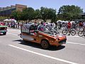
The city celebrates its many cultures with annual events. The biggest is the Houston Livestock Show and Rodeo. It lasts for 20 days in March. It is the largest rodeo in the world. Other events include the Houston Art Car Parade and the Houston International Festival.
Houston is also known for its great food. It has many different types of restaurants. Houston's official nickname is "Space City" because of NASA. Other nicknames include "Bayou City" and "H-Town."
Arts and Theater Scene

The Houston Theater District is in Downtown. It has many performing arts groups and halls. It is one of the largest theater areas in the U.S.
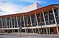
Houston has professional groups for opera, ballet, music, and theater. These include the Houston Grand Opera and the Houston Symphony Orchestra. Many Broadway shows and concerts come to Houston. The Hobby Center for the Performing Arts is a popular venue.
The Houston Museum District attracts over 7 million visitors each year. Famous museums include The Museum of Fine Arts, the Houston Museum of Natural Science, and the Children's Museum of Houston. The Houston Zoo is also in this area.
Houston has a strong music scene, especially for Houston hip hop. Many famous hip-hop artists are from Houston. These include Destiny's Child, Travis Scott, and Megan Thee Stallion.
Fun Things to Do
The Houston Theater District is a great place for entertainment. It has restaurants, movies, and parks. Bayou Place is a large building with food, music, and games. The Bayou Music Center hosts live concerts.
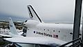
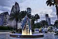
Space Center Houston is NASA's official visitor center. You can see Moon rocks and a Space Shuttle simulator there. Other fun places include The Galleria shopping mall and the Downtown Aquarium.
Houston has many parks. These include Hermann Park, Memorial Park, and Discovery Green. Hermann Park has the Houston Zoo and the Houston Museum of Natural Science. Houston has one of the largest areas of parks and green space among big U.S. cities. The Lee and Joe Jamail Skatepark is a large public skatepark.
The Gerald D. Hines Waterwall Park is a popular spot for visitors and events. Houston is also becoming more walkable.
Sports Teams and Events

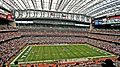
Houston has professional sports teams in almost every major league. The Houston Astros baseball team has won the World Series twice, in 2017 and 2022. The Houston Rockets basketball team has won two NBA Championships in 1994 and 1995. The Houston Texans are the city's football team. The Houston Dynamo soccer team has won two MLS Cup titles. The Houston Dash is a women's soccer team that won a title in 2020.

The Astros play at Daikin Park. The Rockets play at Toyota Center. The Texans play at NRG Stadium. NRG Stadium was the first NFL stadium with a retractable roof and natural grass.
Houston has hosted many big sports events. These include the Super Bowl and the World Series. It will also host matches for the 2026 FIFA World Cup.
Learning in Houston: Schools and Colleges

Houston has many school districts. The Houston Independent School District (HISD) is the largest in Texas. It has over 100 special schools called magnet or vanguard schools. These schools focus on different subjects like health or arts. There are also many private schools in Houston.
Colleges and Universities
Houston has four state universities. The University of Houston (UH) is a large research university. It has almost 44,000 students. Texas Southern University (TSU) is one of the largest historically black universities in the U.S.
Several private universities are also in Houston. Rice University is a very selective private university. It is known for its research. The University of St. Thomas is Houston's only Catholic university. Houston Christian University is also a private university.
Houston also has several community colleges. These include the Houston Community College System (HCC) and the Lone Star College System. They are among the largest colleges in the U.S.
The Texas Medical Center has many health schools. These include two medical schools and four nursing schools.
-
Texas Southern University is the first public university in Houston.
-
The University of Houston–Downtown is the second-largest university in Houston.
-
The University of Houston is a public research university.
-
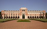
Rice University is a selective private university.


Getting Around Houston: Transportation
Most people in Houston drive alone to work. However, more people are choosing to walk or use public transportation. A study found that many Houston residents prefer living in walkable areas.
Roads and Freeways

The Houston area has over 25,000 miles of roads. This includes many freeways. Houston has a "hub-and-spoke" freeway system. This means freeways spread out from Downtown. Ring roads connect these freeways.
Three Interstate highways cross Houston: I-10, I-45, and I-69. There are also three loop freeways. The innermost loop is I-610. The middle loop is Beltway 8. The outermost loop is State Highway 99, also called the Grand Parkway.
Some roads in Houston are toll roads. You have to pay to use them. The Houston TranStar center monitors the freeway system. It helps with transportation and emergencies.
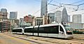
Public Transit

The Metropolitan Transit Authority of Harris County (METRO) provides public transportation. This includes buses, light rail, and special carpool lanes. METRO's bus network serves about 275,000 riders daily.
METRO started its light rail service in 2004. It now has three lines. These lines connect Downtown, the Museum District, and the Texas Medical Center. The light rail system had about 16.8 million riders in 2016.
Amtrak train service connects Houston to other cities. There are also many bike paths in Houston. The city is working to add even more bike trails.
Airports
.jpg)
Houston has three major public airports. George Bush Intercontinental Airport (IAH) is a very busy airport. It serves many domestic and international flights. It served 40 million passengers in 2016. It is a major hub for United Airlines.
William P. Hobby Airport (HOU) handles shorter flights. In 2015, Southwest Airlines started international flights from Hobby. This was the first time since 1969. Hobby Airport was named the first 5-Star Airport in North America by Skytrax in 2022.
Ellington Airport is used by the military, government, and private planes.
Images for kids
-
Hurricane Harvey flooding.
-
Aerial view of central Houston, March 2018.
-
Houston's superneighborhoods.
-
Intersection of Bagby and McGowen streets in western Midtown, 2016.
-
The University of Houston–Downtown.
-
The former Houston Independent School District headquarters.
-
MD Anderson Cancer Center.
-
METRORail light rail.
-
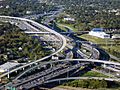
The Interstate 10 and Interstate 45 interchange.
-
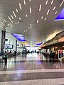
Newest part of Terminal C at George Bush Intercontinental Airport.
-
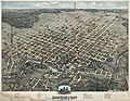
Houston, around 1873.
-
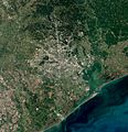
Satellite view of Houston, 2020.
-
Buffalo Bayou after Hurricane Harvey, August 2017.
-
Space Shuttle Independence replica covered in snow, 2017.
-
Map of ethnic groups in Houston, 2010.
-
Debre Selam Medhanealem Ethiopian Orthodox Tewahdo Church.
-

The annual Houston Livestock Show and Rodeo.
-
Houston Art Car Parade.
-
Johnson Space Center, 1989.
-
Fountain of the Downtown Aquarium, Houston.
-
Hobby Center for the Performing Arts.
-
Toyota Center is home of the Houston Rockets.
-
NRG Stadium is the home of the Houston Texans.
-
The current Houston Chronicle headquarters.


See also
 In Spanish: Houston para niños
