List of World Heritage Sites in Chile facts for kids
The United Nations Educational, Scientific and Cultural Organization (UNESCO) helps protect special places around the world. These places are called World Heritage Sites. They are important for their culture or natural heritage. Chile joined the UNESCO World Heritage Convention in 1980.
Right now, Chile has 6 amazing places listed as World Heritage Sites. As of 2014, Chile also has 17 other places on a "tentative list." This means they might become World Heritage Sites in the future. Most of these are cultural sites, and two are natural sites.
Chile's first World Heritage Site was added in 1995 in Germany. This was the Rapa Nui National Park.
Chile's World Heritage Sites
Here's a list of Chile's special World Heritage Sites:
- Name: How UNESCO officially lists the site.
- Location: The region and province where the site is found. If it's a site shared with other countries, those countries are noted.
- Coordinates: The exact geographic location of the site.
- Date of Inscription: The year the site was added to the World Heritage List.
- Criteria: The reasons why the site was chosen. Criteria (i) to (vi) are for cultural sites, and (vii) to (x) are for natural sites.
- Description: A short explanation of the site from UNESCO.
- ID: The special reference number given by UNESCO.
‡ Shared site with other countries ![]() Was once in danger
Was once in danger
| Name | Image | Location | Date of Inscription | Criteria | ID | Description |
|---|---|---|---|---|---|---|
| Rapa Nui National Park | 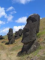 |
Easter Island 27°05′S 109°16′W / 27.09°S 109.27°W |
1995 (19th session) |
Cultural (i), (iii), (v) |
715 | "Rapa Nui is the local name for Easter Island. It shows a unique culture. People from Polynesia settled here around 300 AD. They created amazing giant stone statues called moai and special buildings. This culture was very creative and didn't get ideas from outside. From the 900s to the 1500s, they built shrines and put up these huge stone figures. This created a special landscape that still fascinates people today." |
| Churches of Chiloé | 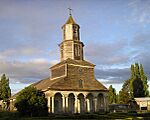 |
42°18′S 73°28′W / 42.30°S 73.46°W |
2000 (24th session) |
Cultural (ii) (iii) |
971 | "The Churches of Chiloé are special because they are made of wood. They are a unique example in Latin America of church architecture. This style started with Jesuit missionaries in the 1600s and 1700s. Franciscans continued and improved it in the 1800s, and it's still seen today. These churches show the rich culture of the Chiloé Archipelago. They are a great example of how local and European cultures mixed. Their design fits perfectly with the landscape, and they show the strong spiritual beliefs of the communities." |
| Historic Quarter of the Seaport City of Valparaíso |  |
33°02′S 71°37′W / 33.04°S 71.61°W |
2003 (27th session) |
Cultural (iii) |
959 | "The old city of Valparaíso is a great example of how cities developed in Latin America in the late 1800s. It's built like an amphitheater in a natural setting. The city has a unique style of buildings that fit the hillsides, with many church spires. This is different from the straight streets found on flat ground. The city still has its interesting old industrial structures, like the many 'elevators' that go up the steep hills." |
| Humberstone and Santa Laura Saltpeter Works | 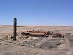 |
20°07′S 69°28′W / 20.12°S 69.47°W |
2005 (29th session) |
Cultural (ii), (iii), (iv) |
1178 | "The Humberstone and Santa Laura sites have over 200 old saltpeter factories. Workers from Chile, Peru, and Bolivia lived in company towns here. They created a special culture called 'pampinos.' This culture was known for its language, creativity, and teamwork. They also fought for social fairness, which greatly impacted history. These sites are in the remote Pampas, one of the driest deserts. Thousands of pampinos lived and worked here for over 60 years, starting in 1880. They processed the world's largest saltpeter deposits. This produced sodium nitrate, a fertilizer that changed farming in North and South America and Europe. It also brought great wealth to Chile. Because the buildings were fragile and an earthquake hit, the site was put on the List of World Heritage in Danger to get help for its protection. In 2019, it was removed from the 'in danger' list." |
| Sewell Mining Town | 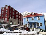 |
34°03′S 70°13′W / 34.05°S 70.22°W |
2006 (30th session) |
Cultural (ii) |
1214 | "Sewell Mining Town is located 2,000 meters high in the Andes mountains. It's about 60 km east of Rancagua. The weather here can be very extreme. The Braden Copper company built Sewell in 1905 to house workers for the El Teniente copper mine. This mine became the world's largest underground copper mine. Sewell is a great example of 'company towns.' These towns were built in remote places around the world. They combined local workers and resources from industrial countries to mine valuable natural resources. The town was built on very steep land, so there were no roads for cars. Instead, there was a large central staircase starting from the train station. Along this staircase were public squares with trees and plants. The buildings were made of timber, often painted in bright colors like green, yellow, red, and blue. At its busiest, Sewell had 15,000 people. But it was mostly left empty in the 1970s." |
| Qhapaq Ñan, Andean Road System‡ | 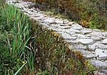 |
2014 (38th session) |
Cultural (ii)(iii)(iv)(vi) |
1459 | "This site is a huge network of Inca roads, covering 30,000 km. The Incas built it over many centuries, partly using older roads. This amazing network goes through some of the world's toughest places. It connects the snowy peaks of the Andes (over 6,000 meters high) to the coast. It passes through hot rainforests, fertile valleys, and dry deserts. It was largest in the 1400s, spreading across the entire Andes. The Qhapac Ñan includes 273 parts spread over 6,000 km. These parts show the Incas' social, political, building, and engineering skills. It also includes places for trade, lodging, storage, and religious sites." | |
| Archaeological sites of the Chinchorro culture | 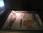 |
18°17′S 70°11′W / 18.28°S 70.19°W 23°24′S 70°15′W / 23.40°S 70.25°W 19°03′S 70°02′W / 19.05°S 70.04°W |
2021 (44th session) |
Cultural (iii)(v) |
1634 | "Around 7000 BC, groups of hunters from the Andes started moving to the coast in northern Chile. They used the resources from the Pacific Ocean, probably because of climate changes after the last ice age. During this time, called the Archaic period, these hunters slowly learned to use coastal tools. This led to the first fishing societies in the area. They used special fishing hooks made from shell, which attracted fish. These groups lived between 6000 and 2000 BC in the desert area from southern Peru to Antofagasta in Chile. The best evidence of their life is found at the mouth of the Camarones River. The Chinchorro people continued hunting nearby and using local resources. But since most of their food came from the sea, they settled on the coast. They lived in houses built in circular holes in the ground with wind-shields. Near their homes, they left their trash, especially shells. They also buried many of their dead, wanting to preserve their bodies. So, 3000 years before Egypt, they developed a way to mummify bodies. This tradition lasted about 4000 years and is known as the Chinchorro culture." |
Places on Chile's Tentative List
Besides the sites already on the World Heritage list, countries can keep a list of places they might nominate in the future. A site must be on this "tentative list" before it can be nominated for the main list. As of 2017, Chile had 17 sites on its tentative list.
- Name: How UNESCO officially lists the site.
- Location: The regions and province where the site is found, and its geographic coordinates.
- Date of submission: When the site was added to the Tentative List.
- Criteria: The reasons why the site might be chosen. Criteria (i) to (vi) are for cultural sites, and (vii) to (x) are for natural sites.
- Description: A short explanation of the site.
- ID: The special reference number given by UNESCO.
| Name | Image | Location | Date of Submission | Criteria | ID | Description |
|---|---|---|---|---|---|---|
| Ayquina and Toconce | 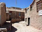 |
22°09′S 68°05′W / 22.15°S 68.09°W 22°10′S 68°11′W / 22.16°S 68.19°W |
1 September 1998 | Cultural (ii)(iii)(iv)(v)(vi) |
1192 | "These villages are in a traditional Andean area. They are small towns with an economy based on sharing and trading. They raise animals like llamas and alpacas (Camelidae) and grow many different vegetables on terraces. Ayquina (2,980 meters above sea level) is a village built closely together in a dry valley. It's on the side of the Salado River Canyon, on a rock wall 40 to 50 meters high. The village has a central area with a church and square, and houses built like stairs on both sides. Ayquina is in a place where the desert climate changes to a high-altitude desert. The small village of Toconce, 3,350 meters above sea level, is the easternmost community near the Bolivian border. It's in a high-altitude desert area. The town is high up on the southern side of the Toconce River, looking over the Paniri, Leon, and Toconce volcanoes." |
| Baquedano Street |
20°08′S 70°06′W / 20.13°S 70.10°W |
1 September 1998 | Cultural (ii)(v) |
1189 | "The buildings in Iquique, especially on Baquedano Street, were built to handle the local climate. They used smart building methods and designs. The buildings on Baquedano Street, and other traditional ones, were stores or homes of rich immigrants who made money from nitrate mining. These buildings have three main features: they are made of Oregon pine (imported from far away), they use a simple 'Ballon Frame' construction, and their style is 'American' (like Georgian or Greek Revival). These buildings often have continuous fronts, are tall and light, and have spaces organized around a central area. They also have vestibules, verandas, skylights, watchtowers, and shaded roofs. Baquedano Street starts at Prat Square, forming a beautiful urban area that shows the history of the nitrate boom. Important buildings here include the Clock Tower, the Tarapaca's Employees Society Building, the Municipal Theater, and the Astoreca Palace. Other valuable buildings are the Yugoslav Club, the former Courts of Justice, and the Spanish Social Club." | |
| Cerro El Plomo high shrine |  |
33°08′S 70°07′W / 33.13°S 70.12°W |
1 September 1998 | Cultural (ii)(iii)(vi) |
1194 | "On March 30, 1954, a Chilean newspaper announced an amazing archaeological find. It was the frozen body of an 8 or 9-year-old child. The Incas had sacrificed this child on top of one of the highest mountains in the Andes, near Santiago. People had known about traces of buildings on the path up this hill since the late 1800s. Mountain climbers, mule drivers, and gold seekers found signs of Inca presence on Cerro El Plomo. This finally led to the discovery of this shrine and the child's body in 1954. The discovery was very exciting for experts at the time. The child's frozen body still had fingerprints, and his remains and valuable belongings were untouched. The Cerro El Plomo High Shrine shows the Inca's worship of mountains. This was a key part of their view of the world and was linked to beliefs about fertility." |
| Churches of the Altiplano | 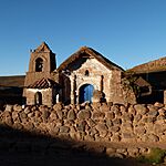 |
19°00′S 69°06′W / 19.00°S 69.10°W |
1 September 1998 | Cultural (ii)(iii)(v) |
1187 | "In the late 1500s, the first missionaries arrived in Tarapaca. Their goal was to teach Christianity to the local people. For this, they built small temples. Their design and construction are part of a style called 'Andean mestizo.' There are at least fifty churches in this group. They look similar and are built using simple techniques with stone, adobe (mud brick), mud, wild straw, and local wood. However, they also have some differences based on the geography, products, and social life of each place. Still, they clearly form a group that shows a natural, non-professional style of architecture that lasted for centuries. The missionaries built these temples at the edge of existing small villages without changing the village layout." |
| Fell and Pali Aike Caves | 
|
52°01′S 70°02′W / 52.02°S 70.03°W 52°05′S 69°25′W / 52.08°S 69.42°W |
1 September 1998 | Cultural (iii)(iv) |
1204 | "The first people to live in the very south of America came from the north by land. They settled in southern Patagonia about 11,000 years ago. This was when the ice from the last ice age had melted back to the Andes mountains, making the climate milder. Evidence of these first hunter-gatherer groups, known as 'Paleoindian,' has been found in the volcanic area of Pali Aike, near the Magallanes Strait. The most important sites are the Fell Cave, which shows how these groups developed over time, especially their tools. The Pali Aike Cave has other artifacts, including three cremated human skeletons. These show that they performed burial ceremonies and give important information about what these ancient people looked like." |
| Houses of the hacienda San José del Carmen el Huique | 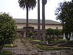 |
34°16′S 71°17′W / 34.27°S 71.28°W |
1 September 1998 | Cultural (ii)(iii)(v) |
1198 | "The houses of the Hacienda El Huique truly show the traditional way of life on Chilean farms. They are also an amazing example of rural farming at the start of the Republic of Chile. Thanks to the care of its owners, whose family kept the property for two centuries, and the management of the Army (which has protected and improved the area since 1976), and the local workers, this historic property can be enjoyed by everyone as a site museum." |
| Juan Fernández Archipelago National Park | 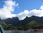 |
33°43′S 79°52′W / 33.72°S 79.86°W |
30 March 1994 | Natural (x) |
84 | "Juan Fernández Archipelago National Park is a protected area of 93 square kilometers. It covers 95% of the land area of a group of islands in the ocean. These islands are 360 to 450 nautical miles off the coast. The islands are the tops of volcanoes that formed from a 'hot spot' in the middle of the Nazca plate. Biologically, the islands have many unique plants and animals found nowhere else. This is common for islands, but what makes this case special is a unique mix of where species came from. Some are related to tropical America, others to Antarctica, and some to Asia and Australia. Also, being isolated for so long has led to unique species, and even a unique plant order called Lactoridales. This is very important for studying how related plant orders evolved. The National Park was created in 1935, and since 1968, park rangers have been protecting it." |
| La Moneda Palace | 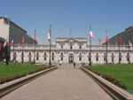 |
33°16′S 70°24′W / 33.27°S 70.40°W |
1 September 1998 | Cultural (ii)(iii)(iv)(v) |
1195 | "The area around La Moneda Palace was greatly changed starting in 1930. Its south side was improved, squares were added at both fronts, and strong buildings for public offices were built around it. The last major restoration of the building happened after it was badly damaged during the 1973 military coup. The Ministry of Public Works' Architecture Office led this restoration, which finished in 1981. They aimed to bring back the original design by the architect Toesca. The Palace still has the style, strength, and balance that its architect gave it. This, along with its important roles, is why Chileans hold this building in such high regard." |
| Locomotive depot of the Temuco Railroad Station | 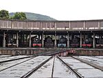 |
38°26′S 72°22′W / 38.44°S 72.37°W |
1 September 1998 | Cultural (iv) |
1200 | "The railroad officially arrived in Temuco on January 1, 1893. It's believed that the first place to store locomotives was a few meters north of the current one. This land was given to the State Railroad Company by the Mapuche people. Temuco became an important railroad hub where long-distance trains would switch locomotives. This depot also housed the locomotives for trains going to towns like Carahue, Cunco, and Cherquenco. In the early 1900s, complex repairs and maintenance for locomotives were done at the Temuco depot. After the San Bernardo Machine Shop opened in 1920, the Temuco depot continued to do simpler repairs." |
| Malleco Viaduct | 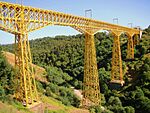 |
37°35′S 72°16′W / 37.58°S 72.27°W |
1 September 1998 | Cultural (i)(iv) |
1199 | "The Malleco Viaduct was once considered the highest railroad bridge in the world. It is one of the largest metal engineering projects in Chile. It was built as part of a big government plan to expand the railroad network. President José Manuel Balmaceda believed this was key for the country's economic future. The bridge was part of building the railroad line between Angol and Traiguén. The Chilean State managed this project through public bidding. Crossing the Malleco River valley was the main challenge, as the riverbed is 110 meters below the plains." |
| Monte Verde Archaeological Site |  |
30°10′S 73°07′W / 30.17°S 73.12°W 41°18′S 73°07′W / 41.30°S 73.12°W |
23 February 2004 | Cultural (iii)(iv) |
1873 | "The Monte Verde archaeological site is in the sub-Antarctic and evergreen softwood forest region, in the low mountains of southern Chile. This site shows that a group of people lived there along the beaches and sandbanks of a small stream about 14,800 years ago. This date is based on carbon-14 dating. After these people lived there, a layer of peat from a swamp covered the entire site. This helped preserve this snapshot of human history. Archaeologists from the Austral University of Chile found remains of housing, wooden tools, plant foods like wild potatoes, and animal bones. Among these were bones of 5 or 6 mastodons, showing they were either hunted or eaten as carrion. This proves that early humans adapted well to the humid temperate forest of the 'Valdiviano' type." |
| Rupestrian art of the Patagonia | 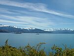 |
46°06′S 72°06′W / 46.10°S 72.10°W 46°18′S 72°00′W / 46.30°S 72.00°W 53°17′S 70°26′W / 53.29°S 70.44°W |
1 September 1998 | Cultural (i)(ii)(iii) |
1203 | "Near Lake General Carrera, east of the southern Andes, you can find ancient rock art. This is called the 'Patagonian Art Style,' and it's the oldest in South America. The most famous images are hands, scenes with guanacos, and patterns. Although not perfectly preserved, these paintings reach into some parts of the pampas region north of the Magallanes Strait. Because Patagonia was so isolated from other cultures, the basic features of this art style stayed the same for thousands of years. For example, paintings in the rocky shelter Los Toldos in central Patagonia, on the Atlantic coast, are nearly 10,000 years old. Later, these artworks developed especially in eastern Patagonia. But they also appeared in the sub-Andean area west of the Chile-Argentina border, in places where Chile's geography still has some pampa features." |
| San Francisco Church and Convent | 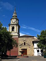 |
33°16′S 70°24′W / 33.27°S 70.40°W |
1 September 1998 | Cultural (ii)(iv) |
1196 | "The San Francisco Church and Convent started from a small chapel called Ermita del Socorro. This chapel was built to house an image of the Virgin Mary. The Spanish conqueror and founder of Santiago, Pedro de Valdivia, brought this image to Chile. This image, carved and painted in Italy, was highly respected by Valdivia and his soldiers. They believed it helped them survive attacks from native people. People continued to worship this image strongly throughout the colonial period, and still do today. In 1554, the Franciscan Order agreed to build a church to house the image from the chapel. In return, they received twelve plots of land facing Cerro Santa Lucia." |
| San Pedro de Atacama | 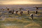 |
22°33′S 68°07′W / 22.55°S 68.12°W |
1 September 1998 | Cultural (ii)(iii)(v) |
1191 | "The Atacama area has a desert climate, with big temperature differences between day and night. Summer rains don't bring more than 100 millimeters per year. The main water sources are the San Pedro and Vilama rivers. The most important geographic feature is the Solar de Atacama, which is 100 kilometers long and 80 km wide. This salt flat formed when underground water, full of mineral salts, came to the surface. When the water evaporated, it left a crust rich in salts and minerals. Rivers, fed by Andean snows, water the area, creating many oases. This is where the Atacama culture developed." |
| The Defensive Complex of Valdivia | 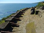
|
39°29′S 73°09′W / 39.49°S 73.15°W 39°30′S 73°15′W / 39.50°S 73.25°W |
1 September 1998 | Cultural (i)(iii)(iv) |
1202 | "The Spanish Crown quickly realized how important Chile's southernmost region was. Through the Magallanes Strait and Cape Horn, it was a key stop for ships traveling from Europe to the American Pacific coast. From the late 1500s, building forts in this area became a top priority. This was because French, English, and Dutch ships often passed through, and especially because of pirate attacks. Francis Drake caused destruction on the Chilean and Peruvian coasts in 1578. Later, expeditions like the Dutch Hendrik Brouwer's, who occupied the coast near the Valdivia river mouth for a time in 1643, aimed to challenge Spanish power from there. These events led the Spanish authorities to build strong defenses in Valdivia, Valparaiso, and Chiloé. Valdivia, the oldest of the three, became one of the most important defensive complexes on the American South Pacific coast, along with El Callao." |
| Torres del Paine and Bernardo O'Higgins National Parks, Region of Magallanes |  |
51°00′S 73°00′W / 51.00°S 73.00°W |
30 March 1994 | Natural (x) |
85 | "Torres del Paine and Bernardo O'Higgins National Parks include over 90% of the Southern Patagonian Icefield. The rest of it, across the border in Argentina, is part of Los Glaciares National Park (a World Heritage Site). The proposed site covers 37,073 square kilometers. Besides the icefield that follows the main Andes range for about 350 km north to south, the site includes other mountain ranges like the Paine Massif. This area is famous for its beautiful scenery and challenging mountain climbing. To the west, the site reaches the Pacific Ocean through many fjords and islands. These show different examples and stages of how glaciers shaped the land and how ecosystems developed after the ice retreated. The area was made a National Park through various government orders from 1959 to 1975." |
See also
 In Spanish: Anexo:Patrimonio de la Humanidad en Chile para niños
- Table of World Heritage Sites by country
- List of World Heritage Sites by year of inscription
- List of World Heritage Sites in South America


