Madison County, Indiana facts for kids
Quick facts for kids
Madison County
|
|
|---|---|

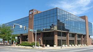
Madison County Courthouse in Anderson
|
|

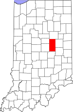
Location within the U.S. state of Indiana
|
|
 Indiana's location within the U.S. |
|
| Country | |
| State | |
| Founded | January 4, 1823 (authorized) |
| Named for | James Madison |
| Seat | Anderson |
| Largest city | Anderson |
| Area | |
| • Total | 452.90 sq mi (1,173.0 km2) |
| • Land | 451.92 sq mi (1,170.5 km2) |
| • Water | 0.99 sq mi (2.6 km2) 0.22%% |
| Population
(2020)
|
|
| • Total | 130,129 |
| • Estimate
(2023)
|
132,504 |
| • Density | 287.324/sq mi (110.9364/km2) |
| Time zone | UTC−5 (Eastern) |
| • Summer (DST) | UTC−4 (EDT) |
| Congressional district | 5th |
| Indiana county number 48 | |
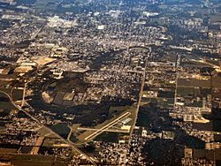
Madison County is a county located in the state of Indiana in the United States. In 2020, about 130,129 people lived here. The main city and county seat (where the county government is) is Anderson. It has been the county seat since 1836. Madison County is part of the larger Indianapolis-Carmel-Anderson metropolitan area.
Contents
History of Madison County
The story of Madison County begins a long time ago. In 1787, the new country of the United States created the Northwest Territory. This huge area included what is now Indiana. Later, in 1800, part of this land became the Indiana Territory.
The United States gained land from Native Americans through agreements called treaties. One important treaty in 1818, called the Treaty of St. Mary's, added a lot of land to the government's control. This new land included the area that would become Madison County.
Madison County was officially created by the state government on January 4, 1823. However, no settlers were allowed to move there until the land was properly surveyed in 1820. After that, the first settlers started to arrive.
The county was named after James Madison. He was one of the people who helped write important documents for the United States. He also served as the fourth President of the United States from 1809 to 1817.
At first, the small town of Pendleton was chosen as the county seat. But people soon wanted a more central location. So, in 1827, the town of Anderson was planned out on land that was given for free. The deal was that the county seat would move there. This move started in 1828 and was finished by 1836.
In 1820, Madison County was covered in thick forests with many different kinds of trees. Settlers cut down many trees and cleared the rest by burning them. Today, most of the land is used for farming or for cities and towns.
In 1887, something exciting happened: natural gas was found in the county, especially near Alexandria and Anderson. Because natural gas was offered for free, many factories came to Madison County, which helped the area grow.
Geography of Madison County
The land in Madison County is mostly flat. However, there are some small hills along the White River and Fall Creek. The highest point is in the southeast corner of the county.
The White River flows through the middle part of the county. Other important streams include Fall Creek, Pipe Creek, and Lick Creek.
According to the 2010 United States Census, Madison County covers about 452.90 square miles (1,173.0 km²). Most of this area is land, with a small amount of water.
Neighboring Counties
- Grant County - to the north
- Delaware County - to the east
- Henry County - to the southeast
- Hancock County - to the south
- Hamilton County - to the west
- Tipton County - to the northwest
Parks and Protected Areas
Cities in Madison County
- Alexandria
- Anderson (the county seat)
- Elwood (part of it)
Towns in Madison County
Small Communities (Unincorporated Towns)
- Alfont
- Alliance
- Bloomer
- College Corner
- Dundee
- Edgewood Village
- Emporia
- Fishersburg
- Florida
- Gimco City
- Hamilton
- Hardscrabble
- Huntsville
- Idlewold
- Leisure
- Linwood
- Moonville
- North Anderson
- Ovid (also known as New Columbus)
- Perkinsville
- Prosperity
- Rigdon
- South Elwood
- Sunview
- Woodlawn Heights
Townships in Madison County
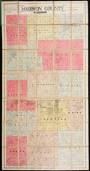
- Adams
- Anderson
- Boone
- Duck Creek
- Fall Creek
- Green
- Jackson
- Lafayette
- Monroe
- Pipe Creek
- Richland
- Stony Creek
- Union
- Van Buren
Main Roads and Highways
 Interstate 69
 U.S. Route 36
 State Road 9
 State Road 13
 State Road 28
 State Road 32
 State Road 37
 State Road 38
 State Road 67
 State Road 109
 State Road 128
 State Road 232
 State Road 236
Railroads
- Central Indiana and Western Railroad
- CSX Transportation
- Indian Creek Railroad
- Norfolk Southern Railway
Climate and Weather
| Weather chart for Anderson, Indiana | |||||||||||||||||||||||||||||||||||||||||||||||
|---|---|---|---|---|---|---|---|---|---|---|---|---|---|---|---|---|---|---|---|---|---|---|---|---|---|---|---|---|---|---|---|---|---|---|---|---|---|---|---|---|---|---|---|---|---|---|---|
| J | F | M | A | M | J | J | A | S | O | N | D | ||||||||||||||||||||||||||||||||||||
|
2.1
33
18
|
2.3
38
23
|
3.2
49
32
|
3.8
61
41
|
4.1
72
51
|
4.2
80
60
|
4.3
84
64
|
3.4
82
62
|
3
75
55
|
2.8
64
44
|
3.7
50
35
|
3
37
24
|
||||||||||||||||||||||||||||||||||||
| temperatures in °F precipitation totals in inches source: The Weather Channel |
|||||||||||||||||||||||||||||||||||||||||||||||
|
Metric conversion
|
|||||||||||||||||||||||||||||||||||||||||||||||
The weather in Anderson, Indiana, changes throughout the year. In January, the average low temperature is about 18°F (-8°C). In July, the average high temperature is about 84°F (29°C).
The coldest temperature ever recorded was -24°F (-31°C) in January 1985. The hottest temperature ever recorded was 105°F (41°C) in July 1954. The amount of rain and snow also changes, with July usually being the wettest month.
Population Information
| Historical population | |||
|---|---|---|---|
| Census | Pop. | %± | |
| 1830 | 2,238 | — | |
| 1840 | 8,874 | 296.5% | |
| 1850 | 12,375 | 39.5% | |
| 1860 | 16,518 | 33.5% | |
| 1870 | 22,770 | 37.8% | |
| 1880 | 27,527 | 20.9% | |
| 1890 | 36,487 | 32.5% | |
| 1900 | 70,470 | 93.1% | |
| 1910 | 65,224 | −7.4% | |
| 1920 | 69,151 | 6.0% | |
| 1930 | 82,888 | 19.9% | |
| 1940 | 88,575 | 6.9% | |
| 1950 | 103,911 | 17.3% | |
| 1960 | 125,819 | 21.1% | |
| 1970 | 138,451 | 10.0% | |
| 1980 | 139,336 | 0.6% | |
| 1990 | 130,669 | −6.2% | |
| 2000 | 133,358 | 2.1% | |
| 2010 | 131,636 | −1.3% | |
| 2020 | 130,129 | −1.1% | |
| 2023 (est.) | 132,504 | 0.7% | |
| US Decennial Census 1790-1960 1900-1990 1990-2000 2010-2019 |
|||
The 2010 United States Census counted 131,636 people living in Madison County. There were 51,927 households, which are groups of people living together.
Most of the people in the county were white (87.7%). About 8.3% were black or African American. People of Hispanic or Latino origin made up 3.2% of the population.
In terms of family life, about 31.3% of households had children under 18 living with them. About 47.4% were married couples. The average household had 2.41 people.
Education
Madison County has several school districts that serve its students:
- Alexandria Community School Corporation
- Anderson Community School Corporation
- Elwood Community School Corporation
- Frankton-Lapel Community Schools
- Madison-Grant United School Corporation
- South Madison Community School Corporation
See also
 In Spanish: Condado de Madison (Indiana) para niños
 | Bayard Rustin |
 | Jeannette Carter |
 | Jeremiah A. Brown |


