
Palliser expedition facts for kids
_(2211818555).jpg)
The Palliser Expedition was a big adventure that explored and mapped the wild lands of western Canada. It was officially called the British North American Exploring Expedition. This journey happened from 1857 to 1860.
The expedition was led by John Palliser, an explorer from Ireland. He had four other main team members. These were James Hector, Eugène Bourgeau, Thomas Blakiston, and John W. Sullivan.
The British government and the Royal Geographical Society supported this trip. Their goal was to collect scientific information. They wanted to learn about the geography, climate, soil, plants (flora), and animals (fauna). This information would help them decide if people could settle there. It would also help plan transportation routes.
This expedition was the first detailed scientific study of the area. It covered the region between Lake Superior and the southern Canadian Rockies. The team's discoveries helped people understand the western frontier better. Their reports led to big changes in the economy and how people settled the land. It also affected transportation and Indigenous communities.
Contents
Who Was on the Expedition?
The main team members were:
- John Palliser, a geographer and leader
- James Hector, a geologist, naturalist, and surgeon
- Eugène Bourgeau, a botanist (plant expert)
- Thomas Blakiston, a magnetic observer (studied Earth's magnetic field)
- John W. Sullivan, a mathematician and observer (used tools like a sextant)
Local guides and interpreters also helped the team. One important guide was Maskepetoon. He later became a chief of a Cree band. He guided the expedition from the Qu'Appelle lakes to the South Saskatchewan River. The expedition members called him Nichiwa, which means 'friend' in Cree.
Why Explore the West?
Early Ideas About the West
Before the expedition, not much was known about the western prairies. People mostly guessed about what the land was like. There were two main ideas about the west.
One idea was that it was a remote and empty wasteland. People thought it was too wild for farming or finding useful resources.
But by the mid-1850s, this idea began to change. People started to see the west differently. This new idea was called the expansionist view. It saw the unknown western lands as a "promised land." They believed it had many chances for successful farming. This view made people think of the west as a great place to settle.
Why the Expedition Was Needed
Only a few Indigenous communities lived in the western prairies. Some British fur traders and missionaries had also been there. But even they didn't know much about the land. Some had collected maps and information, but it was often private.
The British government wanted to know more. They wanted to prove that the west had good land. This led to expeditions like Palliser's and Henry Youle Hind's. Both the Canadian and British governments invested in these trips. They wanted to find new opportunities in the land.
The Palliser expedition had three main goals:
- To explore the land between Lake Superior and the Red River Colony.
- To explore the land between the Red River Colony and the Rocky Mountains.
- To explore the land beyond the Rocky Mountains towards the Pacific Ocean.
The team also checked a route from Lake Superior to Red River. This route was used by the Hudson's Bay Company for trading. They wanted to see if it could be used for travel and moving goods. Palliser also looked at the White Fish River. He wanted to see if it could be a good transportation route. He hoped to connect the Red River Colony to Canada.
The team carefully recorded what they saw. They described different landscapes. This included bodies of water, forests, and mountains.
How the Expedition Was Formed
Some explorers had traveled west from Red River. Many followed routes along the Saskatchewan River. These routes had been used by fur traders for a long time. But Palliser learned about other routes. These were mainly used by Indigenous communities.
In 1848, Palliser met James Sinclair. He was a Métis explorer with the Hudson's Bay Company. Sinclair told Palliser about a different pass. It was near the United States border.
In 1856, Palliser decided to plan a formal expedition. He wanted to explore western Canada along the American border. He proposed his idea to the Royal Geographical Society. This society helped organize research trips. They also worked with the government to fund them.
The society approved Palliser's plan. But they suggested he bring professional scientists. Palliser himself did not have formal scientific training. John Ball, a government official, helped organize the team. The British government gave £5,000 for the expedition. This showed that the government wanted to develop the west.
The team members were trained scientists. James Hector was a geologist, naturalist, and doctor. Eugène Bourgeau was a plant expert. Thomas Blakiston studied geography and magnetism. John W. Sullivan was a mathematician and observer. He also served as the expedition's secretary.
Expedition Routes and Discoveries
Timeline of the Journey
Palliser, Hector, Bourgeau, and Sullivan began their journey in May 1857. They sailed to New York.
1857: Starting the Journey
The team sailed from Sault Ste Marie across Lake Superior and Lake Huron. By June 12, they reached Fort William. This was the starting point for their explorations. The first area they explored was between Lake Superior and Red River.
The expedition continued with horses and carts. The Hudson's Bay Company provided supplies. At Red River, Palliser hired Métis guides. These guides helped with interpreting, scouting, and protection.
In June 1857, they explored White Fish River. They wanted to find river connections. They traveled up the Kaministiquia River and crossed many portages.
They continued along the Red River and across the prairies. They met an American surveyor near the U.S. border. The expedition went through Turtle Mountain, Fort Ellice, and Roche Percée. They followed the South Saskatchewan River to Fort Carlton. Then they went along the North Saskatchewan River. They spent the winter of 1857-1858 there.
1858: Exploring the Rockies
In the spring, they headed west. They looked for mountain crossings west of modern-day Irricana. Palliser and Sullivan mapped the North Kananaskis Pass and North Kootenay Pass. Then they returned to Fort Edmonton for the winter.
Hector crossed the Vermilion Pass and found the Kicking Horse Pass. During the winter, Palliser met with the Blackfoot and Northern Peigan First Nations.
1859: To the Pacific Coast
In 1859, the expedition mapped the meeting point of the Red Deer River and South Saskatchewan River. They also mapped the Cypress Hills. Then they turned west again.
Hector crossed the Rockies through the Howse Pass. He tried to reach the Pacific Coast but couldn't. Palliser and Sullivan crossed the mountains through the North Kootenay Pass. They followed the Kootenay River to Fort Colville. This fort was now in American territory.
Sullivan explored the Columbia River. Palliser traveled overland to Midway, BC. They couldn't find passes to the Pacific north of the 49th parallel. They met Hector again at Fort Colvile.
From there, they traveled down the Columbia River to Fort Vancouver and the Pacific Coast. Then they went north to Fort Victoria. The expedition returned to the East Coast by ship. They sailed through San Francisco and Panama. They had to travel overland in Panama to catch another ship. Finally, they sailed back to Liverpool.
Science and Western Development
The scientific work done on this expedition was very important. It helped understand what types of agriculture could grow there. It also showed opportunities for settlement and transportation.
The expedition collected lots of data. This included information about stars, weather, rocks, and magnetic fields. They described the animals (fauna) and plants (flora) they saw. They also thought about where people could settle and how they could travel.
The research helped redefine the landscape of western British North America. They recorded locations, altitudes, and compass readings. They collected plants and measured rivers. They observed different land features. They compared their measurements to earlier records. They also looked at existing farms and plants in some areas.
Impact of the Expedition
Economy and Expansion
The expedition discovered two main areas. One is now known as the "fertile belt." This land has rich soil between Red River and the Saskatchewan River Valley. The other area is called Palliser's Triangle. This region stretches across the prairies and into the American border. The expedition reported that this area was too dry for farming. However, later officials disagreed, which caused problems for farmers.
The surveys found large amounts of fertile land. This helped change the economy. It shifted from fur-trading to agriculture. After three years, Palliser presented his report to the British Parliament in 1863. A detailed map of the surveyed areas was published in 1865.
The expedition found that traveling through American territory was easier. They found several passes through the Rocky Mountains. But mountains further west stopped them from reaching the Pacific.
This new understanding of the land led to more development in the west. It also helped connect Canada to the west through new transportation routes. One of the passes they explored was later used for the Canadian Pacific Railway. By 1870, agriculture became the main focus in the western prairies. Fur trading continued, but it was less important. The expedition's research helped divide the western prairies into regions. These regions were based on geography, climate, soil, and farming potential.
Settlement and Indigenous Communities
More European settlers moved to western Canada. This led to a growing population. These settlers became a big economic power. This caused conflict with Indigenous communities.
The economy changed very quickly. This affected the Métis and Indigenous people. They lost control over their economic, political, and cultural systems. By the 1870s, the economy in western Canada changed greatly. Indigenous communities became more reliant on European settlers and the government. This happened as they lost their main resource, the buffalo. They began selling their land and moving to reserves.
Images for kids
-
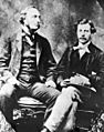
Captain John Palliser and James Hector
-
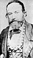
Eugène Bourgeau
-
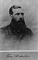
Thomas Wright Blakiston
-
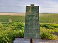
A plaque in Arcola, Saskatchewan, commemorating the Palliser Expedition, as well as the March West and the Fort Ellice-Wood Mountain Trail.


