
Pendleton County, West Virginia facts for kids
Quick facts for kids
Pendleton County
|
||
|---|---|---|

Pendleton County Courthouse
|
||
|
||

Location within the U.S. state of West Virginia
|
||
 West Virginia's location within the U.S. |
||
| Country | ||
| State | ||
| Founded | May 1, 1788 | |
| Named for | Edmund Pendleton | |
| Seat | Franklin | |
| Largest town | Franklin | |
| Area | ||
| • Total | 698 sq mi (1,810 km2) | |
| • Land | 696 sq mi (1,800 km2) | |
| • Water | 2.1 sq mi (5 km2) 0.3%% | |
| Population
(2020)
|
||
| • Total | 6,143 | |
| • Estimate
(2021)
|
6,142 |
|
| • Density | 8.801/sq mi (3.3980/km2) | |
| Time zone | UTC−5 (Eastern) | |
| • Summer (DST) | UTC−4 (EDT) | |
| Congressional district | 2nd | |

Pendleton County is a county in West Virginia, a state in the United States. In 2020, about 6,143 people lived there. This makes it the second-smallest county in West Virginia by population. The main town and county seat is Franklin.
The county was created in 1788 by the Virginia General Assembly, which was Virginia's law-making group. It was formed from parts of Augusta, Hardy, and Rockingham counties. The county was named after Edmund Pendleton (1721–1803). He was an important leader and jurist (a legal expert or judge) from Virginia. During the American Civil War, Pendleton County mostly supported the Confederate side. However, some people in the county were "Unionists," meaning they supported the United States government.
Spruce Knob, the highest point in West Virginia, is located in Pendleton County. It is 4,863 feet tall and is also the highest point in the Alleghenies. Parts of the Monongahela and George Washington National Forests are also found here.
Contents
History of Pendleton County
By the 1740s, explorers and hunters had visited and named the three main valleys in what would become Pendleton County. The first white settler was Abraham Burner, who built a log cabin near the future site of Brandywine in 1745. He saw many deer drinking from the river near his home.
By 1747, more settlers were moving into the area. Many Germans came up the South Branch Potomac valley. Also, many Scotch-Irish people moved northwest from Staunton. During the French and Indian War (1754–1763), there was a surprise attack in April 1758. Shawnee and Delaware warriors attacked Fort Seybert and Fort Upper Tract. Most of the 60 white settlers hiding there were killed, and the forts were burned.
Pendleton County was officially created in 1788. It was named after Edmund Pendleton, a famous Virginia statesman and judge. During the American Civil War, the county was divided. Some areas, like the Smoke Hole community, strongly supported the Union. In June 1863, the U.S. government included Pendleton County in the new state of West Virginia. This happened even though many local people did not want it. That fall, Union General W.W. Averell moved through the South Branch valley. He destroyed the Confederate saltpetre (a chemical used to make gunpowder) factories near Franklin.
After West Virginia became a state, its counties were divided into smaller areas called "civil townships." This was meant to help local governments. But it was hard to do in rural areas. So, in 1872, the townships became "magisterial districts." Pendleton County had six districts: Bethel, Circleville, Franklin, Mill Run, Sugar Grove, and Union. These districts stayed mostly the same until the 1990s. Then, they were combined into three new districts: Central, Eastern, and Western.
In November 1985, Pendleton County and nearby areas had very bad floods. In Franklin, the South Branch of the Potomac River rose to 22.6 feet. This was more than 15 feet above its normal flood level. Sixty-two people died in West Virginia, Virginia, Maryland, and Pennsylvania. These floods were known as the "Killer Floods of 1985" in West Virginia.
Geography of Pendleton County

The county covers about 698 square miles. About 696 square miles are land, and 2.1 square miles (0.3%) are water. It is the fifth-largest county in West Virginia by area. <mapframe latitude="38.68" longitude="-79.36" zoom="9" width="300" height="300" align="right" />
Major Roads
 US 33
US 33 US 220
 WV 28
WV 28 WV 55
WV 55
Neighboring Counties
- Grant County (north)
- Hardy County (northeast)
- Rockingham County, Virginia (east)
- Augusta County, Virginia (south)
- Highland County, Virginia (south)
- Pocahontas County (southwest)
- Randolph County (west)
Protected Natural Areas
- George Washington National Forest (part)
- Monongahela National Forest (part)
- Spruce Knob–Seneca Rocks National Recreation Area (part)
- United States National Radio Quiet Zone (part)
Important Natural Landmarks
- Germany Valley Karst Area
- Sinnett-Thorn Mountain Cave System
Economy and Jobs
Pendleton County's economy mostly relies on small to medium-sized farms and local businesses. Most of these businesses are in Franklin, which is the only official town in the county. The North Fork Valley, on the western side of the county, has many businesses that serve tourists. These visitors come for outdoor activities like hiking and climbing. There are motels, restaurants, and guide services for them.
In recent years, making maple syrup has become a big growing business in the county. Dry Fork Maple Works, the largest maple sugaring operation in West Virginia, is based in Pendleton County. However, most of its syrup production happens in nearby Randolph County.
The county is also home to several non-profits (organizations that work for public good, not for profit). These include Almost Heaven Habitat for Humanity, Future Generations and Future Generations Graduate School, The Mountain Institute, and Mountain Springs Farm and Heritage Center.
Sugar Grove Station, a place where the National Security Agency listens to electronic signals, is located near the southeast part of Pendleton County.
Population and People
| Historical population | |||
|---|---|---|---|
| Census | Pop. | %± | |
| 1790 | 2,452 | — | |
| 1800 | 3,962 | 61.6% | |
| 1810 | 4,239 | 7.0% | |
| 1820 | 4,846 | 14.3% | |
| 1830 | 6,271 | 29.4% | |
| 1840 | 6,940 | 10.7% | |
| 1850 | 5,795 | −16.5% | |
| 1860 | 6,164 | 6.4% | |
| 1870 | 6,455 | 4.7% | |
| 1880 | 8,022 | 24.3% | |
| 1890 | 8,711 | 8.6% | |
| 1900 | 9,167 | 5.2% | |
| 1910 | 9,349 | 2.0% | |
| 1920 | 9,652 | 3.2% | |
| 1930 | 9,660 | 0.1% | |
| 1940 | 10,884 | 12.7% | |
| 1950 | 9,313 | −14.4% | |
| 1960 | 8,093 | −13.1% | |
| 1970 | 7,031 | −13.1% | |
| 1980 | 7,910 | 12.5% | |
| 1990 | 8,054 | 1.8% | |
| 2000 | 8,196 | 1.8% | |
| 2010 | 7,695 | −6.1% | |
| 2020 | 6,143 | −20.2% | |
| 2021 (est.) | 6,142 | −20.2% | |
| U.S. Decennial Census 1790–1960 1900–1990 1990–2000 2010–2020 |
|||
2010 Census Information
In 2010, there were 7,695 people living in Pendleton County. There were 3,285 households and 2,179 families. The population density was about 11 people per square mile. Most people (96.2%) were white. About 1.9% were black or African American. People of Hispanic or Latino origin made up 0.9% of the population.
The average age of people in the county was 47.3 years old. About 24.8% of households had children under 18 living with them. The median income for a household was $33,323. This means half of the households earned more and half earned less than this amount. About 15.1% of the population lived below the poverty line.
Communities in Pendleton County

Towns
- Franklin (county seat)
Magisterial Districts
Current Districts
- Central
- Eastern
- Western
Historic Districts
- Bethel
- Circleville
- Franklin
- Mill Run
- Sugar Grove
- Union
Census-Designated Place
Unincorporated Communities
- Big Run
- Brushy Run
- Cave
- Cherry Grove
- Circleville
- Dahmer
- Deer Run
- Dry Run
- Entry
- Fame
- Fort Seybert
- Harper
- Judy Gap
- Ketterman
- Kline
- Macksville
- Miles
- Mitchell
- Moatstown
- Monkeytown
- Moyers
- Mozer
- Oak Flat
- Oak Grove
- Onego
- Propstburg
- Riverton
- Ruddle
- Seneca Rocks
- Simoda
- Sugar Grove
- Teterton
- Upper Tract
- Zigler
Historic Places to Visit
The following places in Pendleton County are listed on the National Register of Historic Places. This means they are important historical sites.
| Site | Year Built | Address | Community | Listed |
|---|---|---|---|---|
| Ananias Pitsenbarger Farm | 19th century | 3576 Dry Run Road, Franklin | Dahmer, near Franklin | 2011 |
| Bowers House | late 19th century | Brandywine-Sugar Grove Road | Sugar Grove | 1985 |
| Circleville School | 1930s | 81 Price Way, Circleville | Circleville | 1995 |
| Cunningham-Hevener House | late 19th century | US 220 | Upper Tract | 1985 |
| Franklin Historic District | 19th-20th centuries | US 33, Main Street, South Branch Potomac River, and High Street | Franklin | 1986 |
| McCoy House | 1848 | 17 South Main Street, Franklin | Franklin | 1982 |
| McCoy Mill | early 19th century | 293 Thorn Creek Road, Franklin | Franklin | 1986 |
| Old Judy Church (Old Log Church) | early 19th century | US 220 | near Petersburg | 1976 |
| Old Propst Church | late 18th century | CR 21/9 | Brandywine | 1986 |
| Pendleton County Poor Farm | early 20th century | US 220 | Upper Tract | 1986 |
| Priest Mill | early 20th century | Off US 220, near Low-Water Bridge | Franklin | 2000 |
| Sites Homestead (Wayside Inn) | early 19th century | Seneca Rocks Visitor Center | Seneca Rocks | 1993 |
Gallery
-
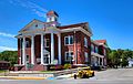
Pendleton County Courthouse
-
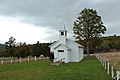
Solomon's Chapel, one of the many smaller churches in Pendleton County, West Virginia
-
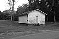
Mount Joel Schoolhouse in Simoda West Virginia


See also
 In Spanish: Condado de Pendleton (Virginia Occidental) para niños
