
San Bernardino, California facts for kids
Quick facts for kids
San Bernardino, California
|
|||||
|---|---|---|---|---|---|
|
San Bernardino County Courthouse
U.S. Post Office
|
|||||
|
|||||
| Nicknames:
SB; San Berdoo; Berdoo; Gate City; City on the Move; The Friendly City; The Heart of Southern California, The 'Dino (sl.)
|
|||||

Location within San Bernardino County
|
|||||

San Bernardino, California
Location in southern California

San Bernardino, California
Location in California

San Bernardino, California
Location in the United States
|
|||||
| Country | United States | ||||
| State | California | ||||
| Metropolitan statistical area | San Bernardino/Riverside | ||||
| Urban Area | Greater San Bernardino Area | ||||
| County | San Bernardino | ||||
| Incorporated | August 10, 1869 | ||||
| Named for | San Bernardino de Sena Estancia, named for Bernardino of Siena | ||||
| Government | |||||
| • Type | Council-manager | ||||
| Area | |||||
| • City | 62.45 sq mi (161.75 km2) | ||||
| • Land | 62.12 sq mi (160.88 km2) | ||||
| • Water | 0.34 sq mi (0.88 km2) 0.74% | ||||
| Elevation | 1,053 (Downtown) ft (321 m) | ||||
| Population
(2020)
|
|||||
| • City | 222,101 | ||||
| • Rank | 1st in San Bernardino County 18th in California 104th in the United States |
||||
| • Density | 3,473.94/sq mi (1,341.30/km2) | ||||
| • Metro | 4,599,839 | ||||
| Time zone | UTC−8 (Pacific) | ||||
| • Summer (DST) | UTC−7 (PDT) | ||||
| ZIP Codes |
92401–92408, 92410–92415, 92418, 92420, 92423, 92424, 92427
|
||||
| Area code | 909, 840, 760 | ||||
| FIPS code | 06-65000 | ||||
| GNIS feature IDs | 1661375, 2411777 | ||||
.jpg)
.jpg)

_(cropped).jpg)
.JPG)


San Bernardino (pronounced SAN BUR-nuh-DEE-noh) is a city in California, United States. It is the main city of San Bernardino County. The city is located in a part of Southern California called the Inland Empire.
In 2020, about 222,101 people lived in San Bernardino. This makes it the 18th largest city in California. San Bernardino is an important center for business, culture, and government in its region. It is also home to California State University, San Bernardino.
The city got its name in 1810 from a Spanish priest named Francisco Dumetz. In 1839, the Mexican government allowed José del Carmen Lugo to settle the area. The community officially became a city in 1854. San Bernardino grew a lot in the late 1800s. It became a key trading spot between Southern California and the American Southwest. Today, it remains an important city in the Inland Empire.
Contents
- History of San Bernardino
- Geography of San Bernardino
- People of San Bernardino
- Economy of San Bernardino
- Arts and Culture in San Bernardino
- Sports in San Bernardino
- Parks and Recreation
- Education in San Bernardino
- Media in San Bernardino
- Transportation in San Bernardino
- Sister Cities
- Images for kids
- See also
History of San Bernardino
Early People of the Valley
The area where San Bernardino is today was once home to the Tongva people. They had several villages in the San Bernardino Valley. One important village was Kaawchama. It was a major trading center. People from different tribes like the Mohave and Serrano used the Mohave Trail to trade here.
Spanish and Mexican Times
In 1771, Spanish missionaries wanted to set up a supply station in the valley. This became the Guachama Rancheria. It was the first Spanish settlement in the San Bernardino Valley. They named it after Bernardino of Siena in 1810.
In 1812, an earthquake destroyed the settlement. Later, the Serrano and Mountain Cahuilla people rebuilt it. In 1819, they invited the missionaries back. The missionaries then built the San Bernardino de Sena Estancia. Local people continued to live there even after the land became part of the Rancho San Bernardino in 1842.
After the American Takeover

_(16475726449)_(cropped).jpg)
The area was not widely settled until 1851. This was after America took over California. The first American settlers were pioneers from the Church of Jesus Christ of Latter-day Saints. They bought the Rancho San Bernardino and started the town in 1851. San Bernardino County was created in 1853.
These settlers used irrigation to farm and cut lumber. They supplied food and wood all over Southern California. The city officially became a city in 1857. Many settlers left later that year. New settlers bought their lands. San Bernardino then became a typical American frontier town.
In 1860, people found gold in the nearby mountains. This started a "gold rush." San Bernardino also became an important trading center. It was a starting point for trails to mines in other areas.
.jpg)
Near San Bernardino, there is a natural rock formation on a mountain that looks like an arrowhead. It is very large. An old Native American story says that an arrow from Heaven made the formation. It showed tribes where they could find healing waters. In the mid-1800s, people believed the water from these springs had healing powers. This led to the creation of the "Arrowhead" bottled water brand.
In 1866, to make way for settlers, a state militia campaign took place. The Yuhaviatam people, led by Santos Manuel, moved to the San Bernardino foothills. In 1891, the U.S. government created a tribal reservation named after Santos Manuel.
Chinese immigrants first arrived in San Bernardino in 1867. In 1883, the California Southern Railroad built a railway link through the city. This connected Los Angeles to the rest of the country.
Modern Times
_(cropped).jpg)
In 1905, San Bernardino passed its first city rules. Norton Air Force Base was built during World War II. It closed in 1994 and became the San Bernardino International Airport.
In 1940, Richard and Maurice McDonald started their first McDonald's restaurant in the city. It had a new way of serving food. In 1955, Glen Bell opened his first taco stand. This later grew into the first Taco Bell restaurant.
San Bernardino won the All-America City award in 1977. In 1989, there was a large train accident. Later that month, a pipeline broke, causing fires.
In 2012, San Bernardino faced major financial problems. The city had to file for a special kind of bankruptcy. It was one of the longest city bankruptcies in the United States. The city came out of bankruptcy in 2017. On December 2, 2015, a tragic attack happened in the city.
Geography of San Bernardino

San Bernardino covers about 59.6 square miles (154.4 square kilometers). Most of this is land. The city is located in the San Bernardino foothills. It is about 60 miles (97 km) east of Los Angeles.
Important natural features include the San Bernardino Mountains and the San Bernardino National Forest. The northern part of the city, Arrowhead Springs, is in these mountains. The San Andreas Fault runs through the northern areas of the city. Several creeks flow into the Santa Ana River, which forms part of the city's southern border.
San Bernardino has a lot of underground water. This is special for a Southern California city. Seccombe Lake is a man-made lake in the city.
Climate and Weather

San Bernardino has a hot-summer Mediterranean climate. This means it has warm winters and hot, dry summers. Winters are colder than in some other parts of Southern California. Frost is common in the mornings. Summers can be very hot, with temperatures sometimes reaching 118°F (48°C).
Snow sometimes falls in the winter. Arrowhead Springs, a neighborhood in the city, gets more snow because it is higher up. The Santa Ana winds are strong in the San Bernardino area. These warm, dry winds increase the risk of wildfires in the fall.
| Climate data for San Bernardino, California, 1981–2010 normals, extremes 1893–2004 | |||||||||||||
|---|---|---|---|---|---|---|---|---|---|---|---|---|---|
| Month | Jan | Feb | Mar | Apr | May | Jun | Jul | Aug | Sep | Oct | Nov | Dec | Year |
| Record high °F (°C) | 94 (34) |
93 (34) |
97 (36) |
103 (39) |
112 (44) |
116 (47) |
116 (47) |
116 (47) |
117 (47) |
111 (44) |
99 (37) |
93 (34) |
117 (47) |
| Mean daily maximum °F (°C) | 68.4 (20.2) |
69.2 (20.7) |
72.7 (22.6) |
77.8 (25.4) |
83.4 (28.6) |
90.1 (32.3) |
96.2 (35.7) |
97.3 (36.3) |
92.8 (33.8) |
84.0 (28.9) |
74.3 (23.5) |
67.1 (19.5) |
81.1 (27.3) |
| Daily mean °F (°C) | 55.6 (13.1) |
56.5 (13.6) |
59.2 (15.1) |
63.5 (17.5) |
68.9 (20.5) |
74.3 (23.5) |
79.9 (26.6) |
80.7 (27.1) |
76.8 (24.9) |
69.0 (20.6) |
59.9 (15.5) |
54.4 (12.4) |
66.6 (19.2) |
| Mean daily minimum °F (°C) | 42.8 (6.0) |
43.8 (6.6) |
45.7 (7.6) |
49.2 (9.6) |
54.3 (12.4) |
58.5 (14.7) |
63.6 (17.6) |
64.2 (17.9) |
60.8 (16.0) |
54.1 (12.3) |
45.5 (7.5) |
41.8 (5.4) |
52.0 (11.1) |
| Record low °F (°C) | 16 (−9) |
21 (−6) |
26 (−3) |
26 (−3) |
33 (1) |
37 (3) |
42 (6) |
40 (4) |
36 (2) |
29 (−2) |
24 (−4) |
19 (−7) |
16 (−9) |
| Average precipitation inches (mm) | 3.15 (80) |
4.06 (103) |
2.53 (64) |
1.02 (26) |
0.25 (6.4) |
0.07 (1.8) |
0.03 (0.76) |
0.13 (3.3) |
0.25 (6.4) |
0.82 (21) |
1.29 (33) |
2.41 (61) |
16.01 (406.66) |
| Average precipitation days (≥ 0.01 in) | 6.0 | 7.2 | 6.8 | 3.2 | 1.7 | 0.6 | 0.5 | 0.5 | 1.4 | 2.4 | 3.2 | 4.8 | 38.3 |
| Source 1: NOAA | |||||||||||||
| Source 2: XMACIS2 | |||||||||||||
People of San Bernardino
| Historical population | |||
|---|---|---|---|
| Census | Pop. | %± | |
| 1880 | 1,673 | — | |
| 1890 | 4,012 | 139.8% | |
| 1900 | 6,150 | 53.3% | |
| 1910 | 12,779 | 107.8% | |
| 1920 | 18,721 | 46.5% | |
| 1930 | 37,481 | 100.2% | |
| 1940 | 43,646 | 16.4% | |
| 1950 | 63,058 | 44.5% | |
| 1960 | 91,922 | 45.8% | |
| 1970 | 106,869 | 16.3% | |
| 1980 | 118,794 | 11.2% | |
| 1990 | 164,164 | 38.2% | |
| 2000 | 185,401 | 12.9% | |
| 2010 | 209,924 | 13.2% | |
| 2020 | 222,101 | 5.8% | |
| U.S. Decennial Census | |||
Population in 2020
The 2020 United States Census showed that San Bernardino had 222,101 people. About 24.2% were non-Hispanic white. About 12.6% were African American. About 2.3% were Native American. About 4.2% were Asian. A large group, 68%, were Hispanic or Latino.
| Race / Ethnicity (NH = Non-Hispanic) | Pop 2000 | Pop 2010 | Pop 2020 | % 2000 | % 2010 | % 2020 |
|---|---|---|---|---|---|---|
| White alone (NH) | 53,630 | 39,977 | 28,649 | 28.93% | 19.04% | 12.90% |
| Black or African American alone (NH) | 29,654 | 29,897 | 26,134 | 15.99% | 14.24% | 11.77% |
| Native American or Alaska Native alone (NH) | 1,129 | 867 | 742 | 0.61% | 0.41% | 0.33% |
| Asian alone (NH) | 7,594 | 8,027 | 8,734 | 4.10% | 3.82% | 3.93% |
| Pacific Islander alone (NH) | 582 | 704 | 754 | 0.31% | 0.34% | 0.34% |
| Other race alone (NH) | 288 | 361 | 1,123 | 0.16% | 0.17% | 0.51% |
| Mixed race or Multiracial (NH) | 4,502 | 4,097 | 4,840 | 2.43% | 1.95% | 2.18% |
| Hispanic or Latino (any race) | 88,022 | 125,994 | 151,125 | 47.48% | 60.02% | 68.04% |
| Total | 185,401 | 209,924 | 222,101 | 100.00% | 100.00% | 100.00% |
Population in 2010

In 2010, San Bernardino had 209,924 people. About 45.6% were White, and 15% were African American. About 60% of the people were Hispanic or Latino.
There were 59,283 households in the city. About half of these households had children under 18. The average household size was 3.42 people. The median age in the city was 28.5 years old.
In 2010, the average household income was $39,097. About 30.6% of the people lived below the poverty line.
Different Cultures in San Bernardino
.png)
Many different groups of people live in San Bernardino. Latino and African-American people make up most of the population. Historically, many Mexican-Americans lived on the West Side. African Americans mostly lived in certain areas like the Medical Center and Base Line.
The largest Asian group in San Bernardino is Filipinos. There is also a growing number of Guatemalan immigrants. The number of white residents has decreased, while the Hispanic and Asian populations have grown.
The most common languages spoken in San Bernardino, besides English, are Spanish and Tagalog.
Economy of San Bernardino


San Bernardino is a key location for moving goods. This is because it is near important mountain passes and major highways. The city has large facilities for shipping and trucking. Big companies like Kohl's, Mattel, and Stater Bros. have warehouses near the San Bernardino International Airport.
When Norton Air Force Base closed in 1994, the city lost many jobs. This caused an economic slowdown. However, the shipping industry has helped the economy grow again. In 2012, over 15% of San Bernardino residents were unemployed. Over 40% received some form of public help. The city has worked to improve its economy since then.
.JPG)
Major Employers
The main types of jobs in San Bernardino are in government, retail, and services. From 1998 to 2004, the number of jobs in San Bernardino grew by 37%. Government jobs were the largest and fastest-growing sector.
Here are some of the top employers in the city:
| Employer | Number of Employees |
|---|---|
| Stater Bros. | 15,000–25,000 |
| County of San Bernardino | 5,000–14,999 |
| San Bernardino City Unified School District | 5,000–14,999 |
| Kohl's | 5,000–14,999 |
| Barrett Business Services, Inc. | 1,000–4,999 |
| San Bernardino Community College District | 1,000–4,999 |
| California Department of Transportation | 1,000–4,999 |
| Loma Linda University Medical Center | 1,000–4,999 |
| City of San Bernardino | 1,117 |
| California State University, San Bernardino | 1,000–4,999 |
Arts and Culture in San Bernardino

.JPG)
.jpg)

San Bernardino hosts several big events each year. These include:
- The Route 66 Rendezvous, a four-day event celebrating America's famous "Mother Road." It happens every September.
- The Berdoo Bikes & Blues Rendezvous, held in the spring.
- The National Orange Show Festival, which started in 1911 and celebrates citrus.
- The Western Regional Little League Championships, held every August.
The historic Arrowhead Springs Hotel and Spa is located in the Arrowhead Springs neighborhood. It has hot springs, mineral baths, and steam caves. The Yaamava Resort & Casino is also nearby.
Museums to Visit
- The Robert V. Fullerton Museum of Art is at California State University, San Bernardino. It has ancient Egyptian items, old pottery from Italy, and art from ancient China. It also shows modern art.
- The Heritage House has a collection from the San Bernardino Historic and Pioneer Society.
- The San Bernardino Railroad and History Museum is inside the old Santa Fe Depot.
- A Route 66 museum is located where the first McDonald's restaurant used to be.
- Other museums include the Inland Empire Military Museum and the American Sports Museum.
Performing Arts Venues

- The 1928 California Theatre (San Bernardino) hosts many events. These include concerts by the San Bernardino Symphony Orchestra. It also shows Broadway plays.
- San Manuel Amphitheater is the largest outdoor theater in the United States.
- The National Orange Show Festival Events Center has several halls and a stadium.
- Coussoulis Arena is the largest venue of its kind in the area.
- The Sturges Center for the Fine Arts hosts talks, concerts, and plays.
- Junior University, a children's theater company, performs musicals at Aquinas High School.
- The historic 1929 Fox Theater of San Bernardino has been restored.
Sports in San Bernardino
.jpg)
The California State University, San Bernardino (CSUSB) Coyotes compete in NCAA Division II sports. San Bernardino Valley College also has sports teams, including football.
CSUSB's baseball team plays at Fiscalini Field. San Bernardino has also had other professional sports teams.
The Glen Helen Raceway hosts off-road motorsport races. The Orange Show Speedway hosts car races.
Inland Empire 66ers Baseball
The city is home to the Inland Empire 66ers baseball team. They are part of the California League. Since 2011, they have been connected with the Los Angeles Angels team. The 66ers play their games at San Manuel Stadium in downtown San Bernardino.
Parks and Recreation

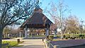
San Bernardino has many parks and places for fun activities. Perris Hill Park is the biggest. It has a bowl for events, a baseball field, tennis courts, a Y.M.C.A., a senior center, and hiking trails.
Other important parks include:
- The Glen Helen Regional Park, located in the northern part of the city.
- Blair Park, which has a skate park and hiking trails on Shandin Hills.
In 2017, San Bernardino opened a new park named after local heroes Bryce Hanes and Jon Cole.
Education in San Bernardino

Most of San Bernardino is served by the San Bernardino City Unified School District. This is the eighth largest school district in California. Some parts of the city are also served by the Colton, Redlands, and Rialto Unified School Districts.
Local public high schools include Aquinas High School, Arroyo Valley High School, Cajon High School, San Bernardino High School, Pacific, San Gorgonio High School, and Indian Springs High School.
Colleges and Universities
San Bernardino is home to California State University, San Bernardino (CSUSB). It is part of the CSU System. CSUSB was founded in 1965.
Other higher education schools in the area include:
- California University of Science and Medicine
- San Bernardino Valley College
- The Art Institute of California – Inland Empire
- American Sports University
- Inland Empire Job Corps Center
- UEI College
- Summit Career College
Media in San Bernardino

San Bernardino is part of the Los Angeles TV and radio market. This means most residents get the same local channels as people in Los Angeles. KVCR-DT, a PBS channel, is the only local TV station in San Bernardino.
San Bernardino has several newspapers:
- The San Bernardino Sun was founded in 1894. It covers news from Yucaipa to Fontana.
- The Precinct Reporter has been publishing weekly since 1965. It mainly serves African American residents.
- The Black Voice News also serves the African American community.
- The Westside Story Newspaper started in 1987 and covers the greater San Bernardino County area.
- The Inland Catholic Byte is the newspaper for the local Catholic church.
- The Los Angeles Times is also widely read.
- El Chicano is a local newspaper for the Mexican-American community.
Transportation in San Bernardino
.jpg)
San Bernardino is part of the Omnitrans and MARTA public transportation systems. The sbX Green Line is a fast bus service. It connects the northern part of the city to Loma Linda. Omnitrans also provides other bus routes. MARTA connects downtown with mountain communities.
Major roads in the city include the San Bernardino Freeway, Barstow Freeway, and Foothill Freeway.
Train Services

Amtrak's Southwest Chief train stops at the San Bernardino station. This train travels between Los Angeles and Chicago.
San Bernardino is also served by Metrolink, a regional train service. Two lines, the Inland Empire–Orange County Line and the San Bernardino Line, serve the city. The San Bernardino Transit Center is a place where passengers can connect to different bus and train services.
Arrow is a new train service to nearby Redlands. It started in 2022.
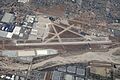
Airports
.jpg)
The San Bernardino International Airport is located within the city. It offers commercial flights. This airport used to be Norton Air Force Base, a military base that closed in 1994. Many warehouses have been built near the airport.
Sister Cities
San Bernardino has "sister cities" around the world. These are cities that have special friendly relationships.
 Villahermosa, Mexico
 Goyang, South Korea
 Herzliya, Israel
 Ifẹ, Nigeria
 Kigali, Rwanda
- Mexicali, Mexico
 Roxas City, Philippines
 Tachikawa, Japan
 Tauranga, New Zealand
 Yushu, China
 Zavolzhye, Russia
Images for kids
-
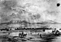
View of San Bernardino in 1852
-
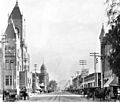
Downtown San Bernardino in 1905
-
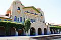
San Bernardino's Santa Fe Depot, built in 1918
-
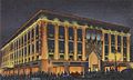
The historic Harris Department Store in 1940
-
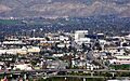
View of Downtown San Bernardino
-
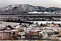
January snowfall in the eastern San Bernardino Valley
-
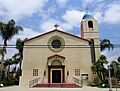
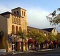
Our Lady of the Rosary Cathedral is a major church in San Bernardino.
-
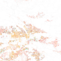
Map of racial distribution in San Bernardino, 2010 U.S. Census. Each dot is 25 people: White, Black, Asian, Hispanic, Other
-
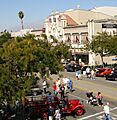
An event in Downtown San Bernardino
-
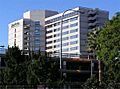
A hotel in Downtown San Bernardino
-
The California Churrigueresque style Harris Company Building
-
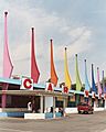
A unique Googie-style car wash
-
The historic Fox Theatre
-
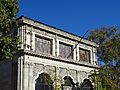
The Spanish Colonial Revival style Heritage Building
-
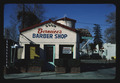
Berneice's Barber Shop, photographed in 1977
-
San Manuel Stadium, home of the Inland Empire 66ers
-
Seccombe Lake Park
-
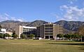
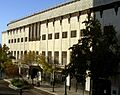
Pfau Library at California State University, San Bernardino
-
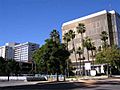
Downtown San Bernardino
-
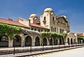
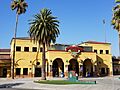
San Bernardino Santa Fe Depot
-
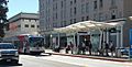
The sbX Civic Center station in Downtown San Bernardino
-
San Bernardino International Airport
See also
 In Spanish: San Bernardino (California) para niños
