
History of San Bernardino, California facts for kids
San Bernardino, California, was named in 1810.
Contents
Early People
San Bernardino's first known residents were the Serrano Indians. Their name means "people of the mountains" in Spanish. They spent winters in the valley and summers in the cooler mountains. They were also called the "Yuhaviatam," or People of the Pines. They lived in the valley for a very long time, starting around 1000 B.C. Their homes were small structures covered with brush. When the Spanish first visited, about 1,500 Serranos lived in the area. They lived in villages of 10 to 30 homes, which the Spanish called rancherías.
The Tongva Indians also called this area Wa'aach in their language.
Spanish Explorers Arrive
A Spanish military leader named Pedro Fages probably entered the San Bernardino Valley in 1772. Later, a priest named Father Francisco Garcés visited the valley in 1774. The de Anza Expedition also passed through that year, but further south of where San Bernardino is today.
The story of how San Bernardino got its name is that Padre Francisco Dumetz, a Franciscan priest, traveled from the Mission San Gabriel Arcángel to the San Bernardino Valley on May 20, 1810. This day was the feast day of Saint Bernardino of Siena. That year, Politana, the first Spanish settlement in the valley, was started. It was a small mission chapel and a place for travelers to get supplies. It was built by the Mission San Gabriel in a village of the Guachama Indians, on a hill now called Bunker Hill.
Mission Life in California
In 1819, the San Gabriel Mission created an estancia, which was like a large farm or ranch, called the San Bernardino de Sena Estancia. It was at an Indian village called Guachama, which is now in Redlands, California. Some adobe buildings were built around 1830. Local Indians dug the Mill Creek zanja, an irrigation ditch, to bring water from Mill Creek to the site for the Franciscans. The estancia closed in 1834 when the mission system was shut down by Governor Figueroa. This site later became known as "Old San Bernardino" and is now called the "San Bernardino Asistencia."
Jedediah Strong Smith, a trapper, entered the valley with 15 other trappers in late November 1826. They were on their way to Mission San Gabriel, crossing the San Bernardino Mountains using the Mojave Trail route over Monument Peak.
The journey of Antonio Armijo in 1829–1830 created the first trade route of the Old Spanish Trail. This trail connected Nuevo Mexico (New Mexico) and Mission San Gabriel in Alta California (Upper California). Their route entered the San Bernardino Valley through a path Armijo called "Cañon de San Bernardino." This path went from the upper Mojave River west through Cajon Pass and then down Crowder Canyon and Cajon Canyon. This path was already known to the vaqueros (cowboys) from the San Bernardino de Sena Estancia. They even helped Armijo's group with food. This path followed Crowder Canyon down to its end at Cajon Canyon, and then to Sycamore Grove.
Kit Carson and other trappers also used the Cajon Pass in 1830. Many early explorers, settlers, and traders used the Cajon Pass to travel further west.
Rancho Days
After the Mexican government closed the Mission system in 1833, several important people in Southern California tried to get the land of Rancho San Bernardino. In 1842, Rancho San Bernardino was given to Antonio Maria Lugo, his sons, and his nephews. They raised about 4,000 to 6,000 cattle in the area. The land grant covered a large part of the San Bernardino valley, about 37,700 acres (153 km2) in total.
To protect their herds from Indian raiders and outlaws, the Lugo family invited settlers from Abiquiu, New Mexico, to live on the rancho at Politana. These settlers arrived in 1842. Don Lorenzo Trujillo led the first group. Later, in 1845, another group of colonists moved to the Santa Ana River and started the village known as Agua Mansa. The Lugos then brought Mountain Cahuilla tribesmen, led by Juan Antonio, to live in Politana and guard their cattle.
In 1843, Michael White, an English man who was a Mexican citizen, was given Rancho Muscupiabe. He built a house overlooking the Cajon Pass, but Native Americans from the desert stole his animals, so he left the Rancho after nine months.
Mormon Settlement

After the Mexican–American War ended in 1847, a group of soldiers called the Mormon Battalion was in California. Some of them, led by Captain Jefferson Hunt, were stationed near the Cajon Pass to protect Mexican ranches from Indian raids. After the war, many of these soldiers returned to Utah. Captain Hunt later got a contract to deliver mail between Salt Lake City and Los Angeles. He also bought cattle from ranches to take to the Mormons in Utah. During this time, he started thinking about buying land in California.
Brigham Young, a leader of the Mormon church, saw Southern California as a good place to get supplies for Utah. It could also be a stop for people traveling and for mail between Salt Lake City and San Pedro. In 1851, a group of almost 500 Mormons left Utah for California. They found plenty of water in the valley, along with many plants like willows and cottonwood. This group was led by Captain David Seely, Captain Jefferson Hunt, and Captain Andrew Lytle. They first camped at Sycamore Grove. They stayed there until they could buy the Rancho San Bernardino.
In September 1851, the Lugo family sold the Rancho to members of the Church of Jesus Christ of Latter-day Saints (Mormons). The Rancho included most of what is now San Bernardino. The price for 40,000 acres (160 km2) was $77,000, with $7,000 paid upfront.
The Mormons built Fort San Bernardino where the county courthouse is today. Inside the fort, they had small stores. Outside, they grew crops like wheat. They later moved outside the fort walls when no attacks happened. The Mormon Council House was built in 1852. It was used as a post office, school, church, and even the county courthouse from 1854 to 1858.

On November 7, 1852, Colonel Henry Washington surveyed the San Bernardino Base Line and Meridian. This point, located east of present-day Highland, is the starting point for all land surveys in Southern California.
San Bernardino County was created from Los Angeles County in 1853, thanks to a bill by Assemblyman Jefferson Hunt, who was a leader of the Mormon group.
In 1853, the Mormons planned the city's street layout, which is still used today. It was a one-mile (1.6 km) square grid, similar to Salt Lake City. Each block was 8 acres (32,000 m2). They also built a road to Los Angeles in 1853. The Mormons started the school system, including Warm Springs, a school still used today.
The City of San Bernardino was officially made a city on April 1, 1854. Mormon Apostle Amasa M. Lyman was the first Mayor. Apostle Charles Coulson Rich became the second Mayor. When the city was formed, there were about 1,200 residents, with 900 of them being Mormons. They were very involved in local government.
The Mormons built the first road for timber to the mountains and a flour mill. In 1855, they brought water from Waterman Canyon to Town Creek using a flume.
The Mormons set aside a "temple block" in the center of the new town, though they never built a temple there. They also created a "Public Square" where they celebrated the 4th of July. Later, after the Mormons left, parts of this land went to the Catholic Church and other individuals. In 1873, the northern part of the block was given to the City. It was first called "City Park," then "Lugo Park," and since 1915, it has been known as Pioneer Park. The Norman F. Feldheym Library was built on this site in 1985. The park also has two Civil War cannons.
.jpg)
The Mormons named the Arrowhead, a natural rock formation above Arrowhead Springs, the "Ace of Spades." On a clear day, you can see the Arrowhead from downtown San Bernardino.
A small Jewish community also formed in Mormon San Bernardino, including Lewis Jacobs and Marcus Katz in 1852. Lewis Jacobs helped start the original Bank of San Bernardino and the Home of Eternity Cemetery. This cemetery, given by the Mormons to the Jewish community, is the oldest Jewish cemetery in Southern California that is still in use. Marcus Katz was an important merchant and community leader.
Some enslaved people were brought to San Bernardino when it was settled. Although California was a free state, slavery was sometimes allowed. Many enslaved people did not know their rights. Judge Benjamin Ignatius Hayes helped free 14 enslaved people, including Biddy Mason. Other enslaved people were also freed by their owners.
The Mormon Recall
In 1857, Mormon leader Brigham Young called many Mormons back to Salt Lake City, Utah. This recall happened for several reasons, including the Utah War and a desire to strengthen the community in Utah. News of the Mountain Meadows massacre, which happened in Utah, also created fear and hostility towards Mormons in California. Because of this, about 2,000 of the 3,000 Mormons in the county left California for Utah. They often sold their land for very little money, just enough for a wagon, team, and supplies for the trip. This was much less than their farms and businesses were worth.
The departure of so many Mormons greatly affected the local economy. The city even stopped being an official city for a while. However, some Mormons stayed behind.
In 1857, three orange trees were planted in Old San Bernardino. These were not the famous Washington Navel Oranges, which came later in 1873 from Brazil to Riverside, California.
Even without the Mormons, the city continued to grow as a business center. Dr. Ben Barton arrived in 1858 and opened a drugstore. He also became the postmaster and County Superintendent of Schools.
The 1860s and 1870s


Gold was found in the Holcomb and Bear Valleys in 1860. For a short time, the boom-town of Belleville almost took the county seat away from San Bernardino, but San Bernardino won by just one vote.
California stayed with the Union during the American Civil War, but there were people in the area who supported the Confederacy. A small fight even happened in the mountains.
Stagecoaches run by Phineas Banning had a stop in downtown San Bernardino during the 1860s.
The Great Flood of 1862 mostly destroyed the earlier settlement of Agua Mansa, which was settled by New Mexicans in the 1830s. The Catholic Church there was rebuilt in downtown San Bernardino in 1865. This wooden church burned down in 1878, and another was built. The current church, at Fifth Street and "F," was built in 1910. The flood also caused a lot of damage along the Santa Ana River.

In 1864, "Dr." David Noble Smith started a "treatment house" at the Arrowhead hot springs. By 1868, it had grown into a hotel. This hotel burned down in 1885. A new hotel was built in 1886, and after it was made bigger to 120 rooms, it was the largest hotel in the San Bernardino area. But it also burned down in 1895. The third hotel was built in 1905. In 1930, Hollywood stars like Loretta Young and Spencer Tracy visited it. A forest fire destroyed this third hotel in November 1938. The current hotel, the fourth one, opened in December 1939. It cost $1.5 million and had six stories. Famous people like Judy Garland attended its grand opening. However, during World War II, the hotel became a naval hospital in 1944. After the war, Elizabeth Taylor spent her honeymoon there. In 1962, Campus Crusade for Christ bought the hotel and used it as their world headquarters. Since 1894, Arrowhead Brand Mountain Spring Water has been pumped from near this site.

A young Wyatt Earp and his family arrived in San Bernardino by wagon train in 1864. His brother, Virgil Earp, later became a town marshal in Colton, California.
In 1866, local militia forces killed Serrano men, women, and children in a 32-day campaign. The Yuhaviatam tribal leader Santos Manuel led the remaining Yuhaviatam from the mountains to the valley floor. The San Manuel reservation is named after him.
In August 1867, the first Chinese immigrants came to San Bernardino. By 1870, there were 16 young men working as laundrymen, cooks, and houseboys. During a tough economic time in 1875, some residents blamed the Chinese for lower wages. In 1878, the Chinese were forced to move to a Chinatown on Third Street. By the late 1890s, San Bernardino's Chinatown had 400–600 residents. Many worked in farming. By the mid-1920s, Chinatown was mostly empty. When buildings were torn down there later, Chinese artifacts were found.
By the 1870s, the City had several large stores and two hotels.
Even though the first orange trees were planted in the county in 1857, the first Washington Navel Orange tree was planted in Riverside (then part of San Bernardino County) in 1873. The area became famous for its oranges. An orange is still on the city seal today, representing all farming in the City.
In 1874, the County built its first permanent courthouse, a two-story building.
Railroads and Growth
.jpg)
In 1873, the Southern Pacific Railroad (SP) wanted to build tracks in San Bernardino, but the city and the railroad couldn't agree. So, the SP started the city of Colton, California, and built its tracks south of San Bernardino. The city's first railroad was the California Southern, which arrived in San Bernardino in 1883. This railroad later became part of the Atchison, Topeka, and Santa Fe Railroad. The original California Southern station was built in 1883 and burned down in 1916. The current station, with its Moorish style, was built in 1918.
The San Pedro, Los Angeles and Salt Lake Railroad started serving San Bernardino in 1905. This railroad, later called the Los Angeles and Salt Lake (LA&SL), used the famous "arrowhead" natural feature north of the city as its logo. The Union Pacific Railroad fully bought the LA&SL in 1921.
San Bernardino grew as a center for trade for the local farms, especially the large orange groves. In 1882, even before Los Angeles, the Opera House opened in San Bernardino. It was a two-story, red brick building that hosted operas, plays, and famous performers like Al Jolson. It could seat between 1,200 and 1,400 people. After being updated in 1912, it also started showing movies. The Opera House was torn down in 1927 to make way for the new courthouse.

A political disagreement about building a new county courthouse in the early 1890s, and attempts to move the county seat, led to the County and City of Riverside splitting off from San Bernardino County. The courthouse was built in 1892. This courthouse was torn down in 1928 after the current courthouse was built in 1927.
A Chinatown developed on Third Street and lasted until the 1920s. Its residents grew vegetables to sell.
In May 1886, the City of San Bernardino officially became a city again.
In 1891, the San Manuel Indian Reservation was created. It was located in the San Bernardino foothills. The land was not good for farming, and the San Manuels lived in poverty until they opened a bingo hall in 1986, and later a casino and water bottling plant. The reservation has since grown in size.
20th Century


By the start of the 1900s, San Bernardino had 6,150 residents. By its "Centennial" in 1910, the population had grown to 12,779.
The National Orange Show first took place in March 1911. It later moved to a permanent location. People often joke about the "Orange Show Curse" because it seems to rain on at least one day of the show every year.
The city continued to grow, mostly north and west of downtown. By the 1920s, new housing areas were built.
The Pacific Electric Railway reached San Bernardino in 1911. This made it easy for residents to travel to Los Angeles and other places.
During the Great Depression and the Dust Bowl, many people from Oklahoma and Arkansas moved to San Bernardino to work in the fields.
The Santa Ana River caused a lot of damage during the Los Angeles flood of 1938. On May 15, 1940, brothers Richard and Maurice McDonald opened the first McDonald's restaurant at 1398 North E Street in San Bernardino.
World War II and After

World War II brought an Army Air Corps base to San Bernardino, later named San Bernardino Army Air Field after Leland Francis Norton, a local hero killed in France in 1944. Camp Ono was another Army base west of the Shandin Hills.
After the war, the city grew a lot. More jobs came from the railroads, Norton Air Force Base, and Kaiser Steel in Fontana. This led to many new homes being built. The city also started a Redevelopment Agency in 1952 to improve the Meadowbrook neighborhood.
City Changes and Challenges
In the 1960s, the Inland Center Mall opened, which meant fewer people shopped downtown. Interstate 15 (now I-215) also divided the town. Mount Vernon Avenue, which had been busy as part of Route 66, started to decline.
During urban renewal in the 1960s, Third Street, once the city's main commercial area, was changed to make way for the Central City Mall.
California State University, San Bernardino opened in 1965. The city worked hard to get this university campus.
In the 1970s, Hospitality Lane was developed in the southern part of San Bernardino. This area now has many offices and businesses, which helps the city's economy.
In 1977, the City was named an "All-America" City.
The Hampshire flood destroyed 40 homes in January 1980. In November 1980, the Panorama fire caused a lot of damage in the city's northern hills. In 2003, the Old Fire caused even more damage. The San Bernardino train disaster happened in 1989 when a train went off its tracks, and a few days later, a nearby pipe exploded.
Steve Wozniak, who helped create Apple Computer, held the US Festival at Glen Helen Regional Park in 1982 and 1983.
Norton Air Force Base officially closed in 1994. This meant 10,000 military and civilian jobs were lost. The base was renamed San Bernardino International Airport, but it didn't have regular airline service. This, along with a recession and job losses from Kaiser Steel and Santa Fe Railroad, hurt San Bernardino's economy. Crime rates also increased as some gangs moved from Los Angeles to San Bernardino.
From the late 1990s to the early 2000s, San Bernardino saw some improvements. The city built a minor league baseball park. Large warehouses were built on the former air force base. Live theater returned to the California Theater.
Recent Events
In 2012, San Bernardino filed for bankruptcy.
Judge Patrick J. Morris became Mayor in 2006. He started a program called "Operation Phoenix" to prevent crime in a high-crime area by combining police work with social services.
Tragic Attack
On December 2, 2015, a tragic event occurred at the Inland Regional Center. Two individuals, Syed Rizwan Farook and Tashfeen Malik, carried out an attack that resulted in 14 deaths and 22 injuries. The attack happened during an event for employees of the San Bernardino County Department of Public Health. The attackers left the scene in an SUV and were later killed by police in a shootout. Farook had attended the event earlier that day.
San Bernardino Today
Some historical parts of San Bernardino still exist today, even though many older buildings have been torn down due to new construction, city improvements, natural disasters, or fires. Some lost buildings include the California Hotel and the Stewart Hotel. Remaining historical buildings include The Andreson Building (now The Enterprise Building), Pioneer Cemetery, the Harris' Company building, the central courthouse, the Pioneer building, Superior Court Judge George E. Otis' house, and the Arrowhead Springs Hotel. The California Theater, a former movie palace, is also still standing. The San Bernardino County Museum has exhibits about the city's history, including a model of Fort San Bernardino. The house where the McDonald brothers lived when they started their first burger restaurant is still on Beverly Drive.
Timeline

- 1810 – Padre Francisco Dumetz names San Bernardino (the valley) on May 20, 1810. Politana, a small mission chapel, was the first Spanish settlement.
- 1812 – Serrano people attacked and destroyed Politana.
- 1829 – San Bernardino Asistencia, a more permanent mission outpost, was built.
- 1830 – The expedition of Antonio Armijo established the first route of the Old Spanish Trail trade.
- 1842 – Rancho San Bernardino was given to Antonio Maria Lugo, covering the entire San Bernardino Valley.
- 1845 – Agua Mansa was founded by colonists from New Mexico.
- 1848 – The Treaty of Guadalupe Hidalgo gave California to the United States.
- 1851 – A Mormon colony was founded on land bought from the Lugo family.
- 1851 – Jewish settlers arrived with the Mormons and started the oldest Jewish cemetery in continuous use on the West Coast.
- 1852 – Colonel Henry Washington set up the survey monument for the San Bernardino Base and Meridian.
- 1854 – San Bernardino officially became a city on April 13.
- 1857 – Brigham Young called many Mormons back to Utah. San Bernardino stopped being an official city. The first orange trees were brought to the valley.
- 1862 – A major flood caused the Santa Ana River to change its course and destroyed nearby Agua Mansa.
- 1863 – A smallpox outbreak affected San Bernardino, causing many deaths among Native Americans.
- 1870 – The city of Riverside, California, was formed.
- 1874 – The first permanent courthouse was built.
- 1875 – The Southern Pacific Railroad reached the valley, stopping at Slover Mountain Colony, which became the City of Colton.
- 1882 – Julia and Joseph Meyer started growing wine grapes in the area now known as Verdemont.
- 1883 – The California Southern Railroad reached San Bernardino. San Bernardino High School became the first high school in the county.
- 1886 – San Bernardino officially became a city again. A passenger rail fare war caused a boom in Southern California.
- 1893 – Riverside County split off from San Bernardino County.
- 1905 – Harris Company opened.
- 1911 – The first National Orange Show was held.
- 1923 – A 6.0 magnitude earthquake shook the Inland Empire area.
- 1926 – San Bernardino Valley College was built.
- 1927 – The San Bernardino County Court House was built.
- 1938 – A major flood from the mountains damaged the city.
- 1940 – San Bernardino's population reached 43,646.
- 1942 – San Bernardino Army Air Field opened (later Norton Air Force Base).
- 1944 – San Bernardino native Leland Francis Norton was killed in action.
- 1948 – Brothers Richard and Maurice McDonald turned their "barbecue" restaurant into a fast food restaurant, McDonald's.
- 1950 – Norton Air Force Base was named after Leland Norton.
- 1961 – Dick and Mac McDonald sold business rights to their restaurants to Ray Kroc.
- 1965 – California State University, San Bernardino was founded.
- 1973 – A new city hall was opened.
- 1977 – The City was named an "All-America" City.
- 1980 – The Panorama Fire burned 24,000 acres, destroying many homes.
- 1985 – Norman F. Feldheym Library was dedicated.
- 1989 – San Bernardino train disaster: A train went off its tracks, and days later, a gas pipeline exploded at the same spot.
- 1994 – Norton Air Force Base closed.
- 1996 – San Bernardino Stadium (later Arrowhead Credit Union Park) opened for minor league baseball.
- 1997 – Mayor Judith Valles was elected, the first Latino mayor in the city's history.
- 2003 – The Old Fire (started by arson) destroyed hundreds of buildings in the foothills and mountains.
- 2006 – Judge Patrick "Pat" J. Morris won the mayoral election.
- 2012 – The City filed for bankruptcy.
- 2015 – 14 people were killed in a terrorist attack at the Inland Regional Center.
Images for kids
-
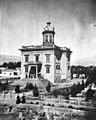
The first permanent Courthouse, 1874
-
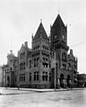
The second permanent courthouse, 1910
-
San Bernardino Valley College Auditorium Tower, circa 1933
-
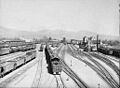
Atchison, Topeka and Santa Fe Railroad yard, San Bernardino, California, 1943
-
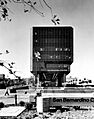
San Bernardino City Hall building designed by César Pelli

